Location
Latitude: |
42-30-14.2190N (42.50395) |
Longitude: |
078-57-02.1240W (-78.95059) |
Elevation: |
830.0 feet MSL (253 m MSL) |
Magnetic Variation: |
10.3 W (as of April 2024 from WMM2020 model) |
Time Zone: |
UTC -5.0 (Standard Time) UTC -4.0 (Daylight Savings Time) |
From City: |
03 N.M. N of Gowanda, New York |
Found On: |
Detroit Chart |
FAA Region: |
AEA |
Contacts
Manager: |
Privately owned: |
| DAN GERNATT, JR. P.O. BOX 400 COLLINS, NY 14034 716-532-3371 |
DAN GERNATT GRAVEL PROD.INC. P.O. BOX 400 COLLINS, NY 14034 716-532-3371 |
Operations
Airport Status: |
Operational |
Facility Use: |
Public |
Type: |
Airport |
Control tower: |
No |
Attendance (Months/Days/Hours): |
Months/Days/Hours Unattended |
Boundary ARTCC: |
ZOB (Cleveland) |
Responsible ARTCC: |
ZOB (Cleveland) |
Segmented Circle Indicator: |
No |
Traffic Pattern Altitude (MSL): |
1830 feet (558 m) |
NOTAMs Facility: |
BUF |
NOTAM-D Service: |
Yes |
Military Landing Rights: |
No |
Civil/Military Joint Use: |
No |
Based Aircraft
| Single Engine: | 5 |
Annual Operations (as of 08/29/2018)
| Total Operations: | 3600 | |
| GA Local: | 3600 | 100.0% |
Communications
| CTAF: | 122.900 |
Fixed Based Operators (FBOs) & Fuel
(Click on a business for detail)
Please help us keep this information up to date. This is a FREE SERVICE just like everything else on Airport Guide! If you see that a business needs to be added, modified, or deleted please fill out our Update Form.
To add, modify, or delete a business click here.
Please help us keep this information up to date. This is a FREE SERVICE just like everything else on Airport Guide! If you see that a business needs to be added, modified, or deleted please fill out our Update Form.
Area Code: 716 |
| Business Name | Frequency | Phone | Fuel Grade |
|---|
Flight Service Stations
| Primary | Alternate | |
| FSS on Field: | N | |
| FSS Name (ID): | Buffalo(BUF) | |
| Frequency: | ||
| Toll Free Phone: | 1-800-WX-BRIEF |
Instrument Procedures / Charts
Terminal Procedures are only available for airports in several countries with more being added all the time. If you are looking for a specific country's charts, please send an email to support(at)airportguide.com stating the country name. This will be used to prioritize the implementation.
Navigation Aids (Navaids) near D59
| Dist (NM) | ID | Morse Code | Name | Type | Freq | True Hdg | Mag Hdg |
|---|---|---|---|---|---|---|---|
| 14.3 | DKK | _ . . _ . _ _ . _ | Dunkirk | DME | 116.2 | 266 | 276 |
| 20.4 | JHW | . _ _ _ . . . . . _ _ | Jamestown | VOR-DME | 114.70 | 201 | 211 |
| 23.0 | GB | _ _ . _ . . . | Plazz | NDB | 204 | 14 | 24 |
| 27.8 | BUF | _ . . . . . _ . . _ . | Buffalo | VOT | 109.00 | 19 | 29 |
| 28.8 | BUF | _ . . . . . _ . . _ . | Buffalo | DME | 116.4 | 27 | 37 |
| 30.3 | LYS | . _ . . _ . _ _ . . . | Olean | NDB | 360 | 115 | 125 |
| 32.6 | BU | _ . . . . . _ | Klump | NDB | 231 | 23 | 33 |
| 36.5 | IAG | . . . _ _ _ . | Niagara Falls | TACAN | 111.00 | 359 | 369 |
| 36.6 | IA | . . . _ | Kathi | NDB | 329 | 7 | 17 |
| 40.8 | SN | St. Catharines | NDB | 408 | 340 | 350 | |
| 45.5 | BFD | _ . . . . . _ . _ . . | Bradford | DME | 116.6 | 160 | 170 |
| 47.1 | ORJ | _ _ _ . _ . . _ _ _ | Corry | NDB | 258 | 221 | 231 |
| 49.0 | ELZ | . . _ . . _ _ . . | Wellsville | DME | 115.85 | 120 | 131 |
| 51.8 | TDT | _ _ . . _ | Tidioute | DME | 117.6 | 203 | 213 |
| 53.4 | ZHM | Binbrook | NDB | 266 | 316 | 326 | |
| 56.2 | CQD | _ . _ . _ _ . _ _ . . | Cascade | NDB | 372 | 246 | 256 |
| 57.3 | GEE | _ _ . . . | Geneseo | VOR-DME | 108.20 | 69 | 80 |
| 59.4 | HM | Hamilton | NDB | 221 | 308 | 318 | |
| 60.2 | AVN | . _ . . . _ _ . | Avon | NDB | 344 | 59 | 70 |
| 63.1 | ZHA | Ancaster | NDB | 397 | 311 | 321 |
Nearby Airports with Fuel
Notices to Airmen (NOTAMS)
Remarks
| A110-1 | TRUCK TRAFFIC NEAR RY 27. |
| A110-3 | RY 09 - +40 FT PLINE; 600 FT FROM THLD ON CNTRLN. |
| A110-5 | RY 09/27 SOFT & WET MAR-JUN. |
| A110-6 | RY 27 88 FT HIGH CONVEYOR BELT/CRANE & DIRT PILE, 200 FT FRM AER, 81 FT LEFT. |
| A110-7 | RY 9/27, DIRT ROAD CROSSES RY AT APPROX MID POINT OF RY. |
| A110-9 | FOR CD CTC CLEVELAND ARTCC AT 440-774-0490. |
| A14 | ALSO SAL DICEMBRE. |
| A51-27 | DTHR UNMARKED. |
| A52-09 | RY 27 CONTROLLING OBSTRUCTION: ACTIVE CRANES & GRAVEL CONVEYOR BELTS. |
| A57-27 | RY 27 88 FT CONVEYOR, 1332 FT FM DSPLCD THLD, 81 FT LT, 15:1 APP SLOPE BASED ON DSPLCD THLD. |
| E111 | VFR OPS ONLY. |
Runways
Runway Summary
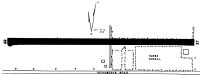
| Runways: | 09/27 |
| Longest Runway: | 09/27 is 3430 ft (1045 m) long |
| Runways with an Instrument Approach: |
D59 Airport Runway Details
| Runway 09/27 | 3430 ft x 100 ft (1045 m x 30 m) | |
| Surface: | Turf - Good condition - No special surface treatment | |
Runway 09 |
Runway 27 |
|
Glide Path Angle: |
0.0 degrees | 0.0 degrees |
Traffic Pattern: |
Right | Right |
Object at End: |
TREE | OTHER |
Object Height: |
11 | 83 |
Object Marked/Lighted?: |
Lighted | |
Distance from End: |
0 | 190 |
Object Centerline Offset: |
35 ft. right of centerline | 69 ft. left of centerline |
REIL: |
No | No |
Touchdown Lights: |
No | No |
Displaced Threshold: |
1132 |
Services
Airframe Repair: |
Major |
Powerplant Repair: |
Major |
Bottled Oxygen: |
None |
Bulk Oxygen: |
None |
Fuel Available: |
100LL, Jet A |
Landing Fees: |
No |
Parking: |
Hangars and tiedowns available |
Other Services: |
Flight School: Cessna 150/152/172 Rentals available. Full time instructors CFII/MEI's. Pilot shop stocked with charts, and pilot equipment. |
Maps & Diagrams
D59 Sectional
Flight Planning
at skyvector.com
at skyvector.com