
Location
Latitude: |
23-23-32.6427N (23.392401) |
Longitude: |
113-17-56.413E (113.299004) |
Elevation: |
50 feet MSL (15 m MSL) |
Magnetic Variation: |
3.4 W (as of April 2024 from WMM2020 model) |
Time Zone: |
UTC +8.0 (Standard Time) UTC +8.0 (Daylight Savings Time) |
Contacts
Manager: |
: |
Operations
Airport Status: |
Operational |
Facility Use: |
Public |
Type: |
Airport |
Traffic Pattern Altitude (MSL): |
1050 feet (320 m) |
Based Aircraft
Annual Operations (as of )
Communications
| TWR: | 118.1 |
| CLD: | 121.95 |
| GND: | 121.75 |
| ATIS: | 128.6 |
| GUANGZHOU: | 120.4 |
Fixed Based Operators (FBOs) & Fuel
(Click on a business for detail)
Please help us keep this information up to date. This is a FREE SERVICE just like everything else on Airport Guide! If you see that a business needs to be added, modified, or deleted please fill out our Update Form.
To add, modify, or delete a business click here.
Please help us keep this information up to date. This is a FREE SERVICE just like everything else on Airport Guide! If you see that a business needs to be added, modified, or deleted please fill out our Update Form.
| Business Name | Frequency | Phone | Fuel Grade |
|---|
Flight Service Stations
| Primary | Alternate | |
| FSS on Field: | ||
| FSS Name (ID): | ||
| Frequency: | ||
| Toll Free Phone: |
Instrument Procedures / Charts
Terminal Procedures are only available for airports in several countries with more being added all the time. If you are looking for a specific country's charts, please send an email to support(at)airportguide.com stating the country name. This will be used to prioritize the implementation.
Navigation Aids (Navaids) near CAN
| Dist (NM) | ID | Morse Code | Name | Type | Freq | True Hdg | Mag Hdg |
|---|---|---|---|---|---|---|---|
| 4.4 | PH | Zhuliao | NDB | 228 | 113 | 116 | |
| 15.6 | FO | Baiyun | NDB | 411 | 191 | 194 | |
| 15.9 | CEN | Cencun | VOR-DME | 114.60 | 155 | 158 | |
| 16.9 | TAN | Yuantan | VOR-DME | 108.60 | 348 | 351 | |
| 19.3 | QM | Yanbu | NDB | 423 | 205 | 208 | |
| 19.6 | CON | Conghua | VOR-DME | 113.00 | 53 | 56 | |
| 23.1 | XK | Pingzhou | NDB | 353 | 195 | 198 | |
| 23.1 | POU | Pingzhou | VOR-DME | 114.10 | 195 | 198 | |
| 35.5 | SHL | Shilong | VOR-DME | 115.70 | 120 | 123 | |
| 35.5 | LQ | Shilong | NDB | 328 | 120 | 123 | |
| 43.0 | QJ | Shenzhen | NDB | 253 | 146 | 149 | |
| 48.8 | BH | Gaoyao | NDB | 317 | 246 | 249 | |
| 48.8 | GYA | Gaoyao | VOR-DME | 116.50 | 246 | 249 | |
| 49.0 | VB | Yingde | NDB | 310 | 6 | 10 | |
| 49.2 | YIN | Yingde | VOR-DME | 113.50 | 7 | 11 | |
| 52.8 | SZX | Shenzhen | VOR-DME | 115.30 | 148 | 151 | |
| 53.7 | NLG | Nanlang | VOR-DME | 117.70 | 164 | 167 | |
| 57.7 | GLN | Guanlan | VOR-DME | 112.00 | 135 | 138 | |
| 58.6 | LMN | Longmen | VOR-DME | 116.30 | 74 | 78 | |
| 58.7 | UF | Longmen | NDB | 275 | 74 | 78 |
Nearby Airports with Fuel
| Dist (NM) | Name (Airport IDs) | True Hdg | Mag Hdg | Fuel Grade |
|---|---|---|---|---|
| 0.0 | Guangzhou Baiyun International Airport (CAN ZGGG) |
0 | 3 | JET A-1 |
| 76.3 | Macau International Airport (MFM VMMC) |
167 | 170 | Jet A-1 |
Notices to Airmen (NOTAMS)
Remarks
No remarks for this landing facility
Runways
Runway Summary
| Runways: | 01/19 02L/20R 02R/20L |
| Longest Runway: | 02L/20R is 12467 ft (3800 m) long |
| Runways with an Instrument Approach: |
CAN Airport Runway Details
| Runway 01/19 | 11811 ft x 148 ft (3600 m x 45 m) | |
| Runway Edge Lights: | Yes Intensity | |
Runway 01 |
Runway 19 |
|
Elevation: |
41 | 43 |
Latitude: |
23.37680053710 | 23.40841293334 |
Longitude: |
113.28399658203 | 113.29195404052 |
|
Runway True Alignment: |
14 | 194 |
Glide Path Angle: |
0.0 degrees | 0.0 degrees |
REIL: |
Yes | Yes |
Threshold Elevation: |
41 | 43 |
| Runway 02L/20R | 12467 ft x 197 ft (3800 m x 60 m) | |
| Runway Edge Lights: | Yes Intensity | |
Runway 02L |
Runway 20R |
|
Elevation: |
45 | 45 |
Latitude: |
23.37569999694 | 23.40889930725 |
Longitude: |
113.30500030517 | 113.31400299072 |
|
Runway True Alignment: |
14 | 194 |
Glide Path Angle: |
0.0 degrees | 0.0 degrees |
REIL: |
Yes | Yes |
Threshold Elevation: |
45 | 45 |
Displaced Threshold: |
700 |
| Runway 02R/20L | 12467 ft x 197 ft (3800 m x 60 m) | |
| Runway Edge Lights: | Yes Intensity | |
Runway 02R |
Runway 20L |
|
Elevation: |
45 | 48 |
Latitude: |
23.36949920654 | 23.40279960632 |
Longitude: |
113.30799865722 | 113.31700134277 |
|
Runway True Alignment: |
14 | 194 |
Glide Path Angle: |
0.0 degrees | 0.0 degrees |
REIL: |
Yes | Yes |
Threshold Elevation: |
45 | 48 |
Services
Fuel Available: |
Jet A-1 |
Other Services: |
Onsite CIQ, dedicated VIP lounge |
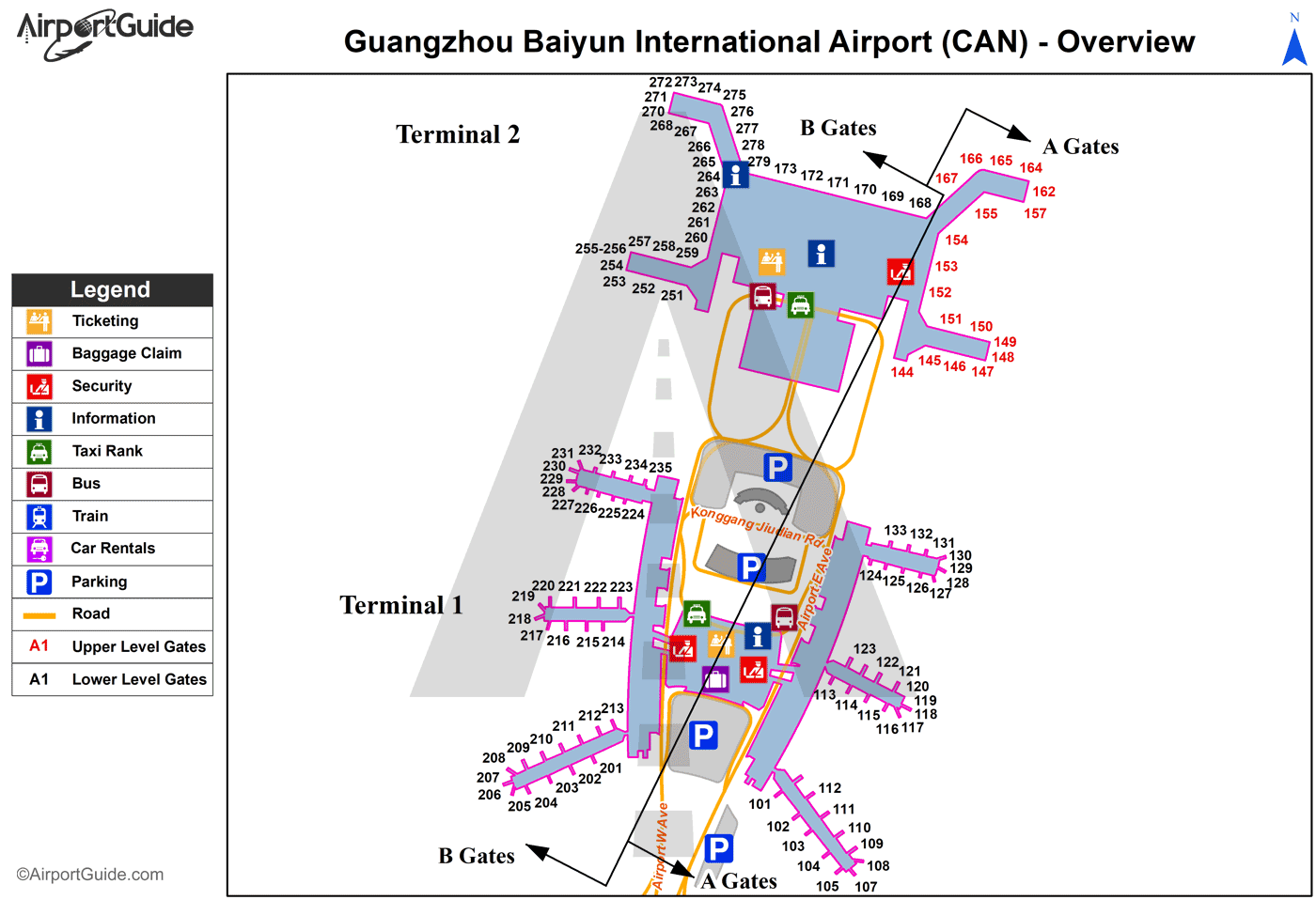
Maps & Diagrams
CAN Sectional
Flight Planning
at skyvector.com
at skyvector.com
