Location
Latitude: |
37-22-23.2000N (37.373111) |
Longitude: |
118-21-49.0000W (-118.363611) |
Elevation: |
4124.3 feet MSL (1257 m MSL) |
Magnetic Variation: |
12.2 E (as of April 2024 from WMM2020 model) |
Time Zone: |
UTC -8.0 (Standard Time) UTC -7.0 (Daylight Savings Time) |
From City: |
02 N.M. E of Bishop, California |
Found On: |
San Francisco Chart |
FAA Region: |
AWP |
Contacts
Manager: |
Publicly owned: |
| MICHAEL ERRANTE, PUBLIC WORKS DIR 703 AIRPORT ROAD BISHOP, CA 93514 (760) 872-2971 |
INYO COUNTY 168 N EDWARDS, PO DRAWER Q INDEPENDENCE, CA 93526 760-878-0201 |
Operations
Airport Status: |
Operational |
Facility Use: |
Public |
Type: |
Airport |
Activation Date: |
04/1940 |
Control tower: |
No |
Attendance (Months/Days/Hours): |
Months/Days/Hours ALL/ALL/0800-1700 |
Boundary ARTCC: |
ZOA (Oakland) |
Responsible ARTCC: |
ZOA (Oakland) |
Lighting Schedule: |
SEE RMK |
Segmented Circle Indicator: |
Yes |
Traffic Pattern Altitude (MSL): |
5124 feet (1562 m) |
NOTAMs Facility: |
BIH |
NOTAM-D Service: |
Yes |
International Airport of Entry: |
No |
Customs Landing Rights: |
No |
Military Landing Rights: |
Yes |
Civil/Military Joint Use: |
No |
Aircraft Rescue and Firefighting: |
Class I ARFF Index: B Air Carrier Service: Scheduled Certification Date: 10/2021 |
Based Aircraft
| Single Engine: | 35 |
| Multi Engine: | 2 |
| Jet Engine: | 1 |
| Ultralights: | 1 |
Annual Operations (as of 08/22/2022)
| Total Operations: | 12500 | |
| Commercial: | 950 | 7.6% |
| Air Taxi: | 250 | 2.0% |
| GA Local: | 3500 | 28.0% |
| GA Itinerant: | 7000 | 56.0% |
| Military Aircraft: | 800 | 6.4% |
Communications
| CTAF: | 123.000 |
| Unicom: | 123.000 |
| ASOS: | 119.025 (760-872-2658) |
- COMMUNICATIONS PRVDD BY RIVERSIDE RADIO ON FREQ 122.6 (BISHOP RCO).
- APCH/DEP CTL SVC PRVDD BY OAKLAND ARTCC (ZOA) ON FREQS 125.75/284.65 (BISHOP RCAG).
Fixed Based Operators (FBOs) & Fuel
(Click on a business for detail)
Please help us keep this information up to date. This is a FREE SERVICE just like everything else on Airport Guide! If you see that a business needs to be added, modified, or deleted please fill out our Update Form.
To add, modify, or delete a business click here.
Please help us keep this information up to date. This is a FREE SERVICE just like everything else on Airport Guide! If you see that a business needs to be added, modified, or deleted please fill out our Update Form.
Area Code: 760 |
| Business Name | Frequency | Phone | Fuel Grade |
|---|---|---|---|
| Airport Management
Update FBO info |
Unicom 123.0 | 872-2971 | 100LL, Jet A |
| Hangar One Aero Service, Inc.
Update FBO info |
873-7500 | ||
| Owens Valley Aviation
Update FBO info |
872-3398 | ||
| Owens Valley Soaring
Update FBO info |
387-2673 | ||
| Sierra Aviation / Sierra Life Flight
Update FBO info |
872-2202 |
Flight Service Stations
| Primary | Alternate | |
| FSS on Field: | N | |
| FSS Name (ID): | Riverside(RAL) | |
| Frequency: | ||
| Toll Free Phone: | 1-800-WX-BRIEF |
Instrument Procedures / Charts
FAA Terminal Procedures valid from 0901Z 03/21/24 to 0901Z 04/18/24.
There are various types of charts available for an airport. They are listed in the Page Type column. Here is a legend for those types:
APD - Airport Diagram
DP - Departure Procedure Charts
HOT - Hot Spots
IAP - Instrument Approach Procedure Charts
MIN - Minimums
STAR - Standard Terminal Arrival Charts
| Page Type | Page Name | Volume | Action Since Last Cycle |
|---|---|---|---|
| APD | AIRPORT DIAGRAM | SW-2 | |
| IAP | LDA RWY 17 | SW-2 | |
| IAP | RNAV (GPS) Y RWY 12 | SW-2 | Changed |
| IAP | RNAV (GPS) Z RWY 12 | SW-2 | Changed |
| IAP | RNAV (RNP) RWY 30 | SW-2 | |
| MIN | ALTERNATE MINIMUMS | SW-2 | |
| MIN | TAKEOFF MINIMUMS | SW-2 |
Terminal Procedures are only available for airports in several countries with more being added all the time. If you are looking for a specific country's charts, please send an email to support(at)airportguide.com stating the country name. This will be used to prioritize the implementation.
Navigation Aids (Navaids) near BIH
| Dist (NM) | ID | Morse Code | Name | Type | Freq | True Hdg | Mag Hdg |
|---|---|---|---|---|---|---|---|
| 0.3 | BIH | _ . . . . . . . . . | Bishop | VOR-DME | 109.60 | 329 | 317 |
| 22.2 | DYY | _ . . _ . _ _ _ . _ _ | Dyer | DME | 114.05 | 49 | 37 |
| 47.1 | OAL | _ _ _ . _ . _ . . | Coaldale | VORTAC | 117.70 | 36 | 24 |
| 61.0 | FRA | . . _ . . _ . . _ | Friant | VORTAC | 115.60 | 255 | 243 |
| 73.2 | MVA | _ _ . . . _ . _ | Mina | VORTAC | 115.10 | 12 | 360 |
| 74.5 | TPH | _ . _ _ . . . . . | Tonopah | VORTAC | 116.00 | 57 | 45 |
| 75.4 | CZQ | _ . _ . _ _ . . _ _ . _ | Clovis | TACAN | 112.90 | 247 | 235 |
| 79.4 | TQQ | _ _ _ . _ _ _ . _ | Silverbow | VORTAC | 113.00 | 71 | 59 |
| 80.5 | FCH | . . _ . _ . _ . . . . . | Chandler | NDB | 344 | 241 | 229 |
| 80.8 | VIS | . . . _ . . . . . | Visalia | VOR-DME | 109.40 | 221 | 209 |
| 84.6 | BTY | _ . . . _ _ . _ _ | Beatty | VORTAC | 114.70 | 113 | 101 |
| 93.1 | TTE | _ _ . | Tule | VOR-DME | 116.25 | 200 | 188 |
| 96.4 | COR | _ . _ . _ _ _ . _ . | Salyer Farms | NDB | 205 | 215 | 203 |
| 97.6 | HYP | . . . . _ . _ _ . _ _ . | El Nido | VOR-DME | 114.20 | 265 | 253 |
| 98.6 | NLC | _ . . _ . . _ . _ . | Lemoore | TACAN | 113.30 | 231 | 219 |
Nearby Airports with Fuel
Notices to Airmen (NOTAMS)
Remarks
| A11 | LEASED, CONSTRUCTED AND MAINTAINED BY INYO COUNTY. CITY OF LOS ANGELES IS UNDERLYING LAND OWNER - 300 MANDICH ST, BISHOP CA 93514 |
| A110-10 | MAIN RAMP IS RSTRD TO PART 121; OTRS USE TSNT RAMP BY FUEL FARM. |
| A110-2 | NO INTXN DEPS; HEL TFC APCH ARPT FM THE WEST BOUNDARY. |
| A110-5 | RAMP FEES FOR COMM ACFT; MAY BE OFFSET WITH FUEL PURCHASE. |
| A110-6 | OVNGT TIE-DOWN FEE; ONE NIGHT MAY BE OFFSET WITH MIN FUEL PURCHASE. |
| A110-7 | FUEL DISCOUNTS FOR VOLUME PURCHASES. |
| A110-8 | NO LOCAL TAXI SERVICE; DIAL-A-RIDE AVBL, BUT LTD ON SUN. |
| A110-9 | FOR CD IF UNA TO CTC ON FSS FREQ, CTC OAKLAND ARTCC AT 510-745-3380. |
| A14 | ASHLEY HELMS, DEPUTY PUBLIC WORKS DIRECTOR - AIRPORTS; AHELMS@INYOCOUNTY.US. |
| A17 | CONDS NOT MNT BTN 1700-0800. |
| A17 1 | ADMIN OFC AT ARPT 760-872-2971. AFTER HRS EMERG: 760-937-4017. |
| A32-12/30 | PVD SHOULDER 10' TO LGTS PLUS 15' TO EDGE. |
| A32-17/35 | PVD SHOULDER 10' TO LGTS PLUS 15' TO EDGE. |
| A43-08 | PAPI UNUSBL BYD 5 NM. |
| A43-17 | PAPI UNUSBL BYD 5 NM. |
| A43-26 | PAPI UNUSBL BYD 2 NM. |
| A43-30 | PAPI UNUSBL BYD 4 NM. |
| A43-35 | PAPI UNUSBL BYD 5 NM. |
| A58-26 | 10' DEEP DITCH 100' FROM THR. |
| A76 | HTTPS://BISHOPFLYING.CLUB/ |
| A81-APT | ACTVT REIL RWY 12, 30, 17, & 35; PAPI RWY 08, 26, 12, 30, 17, & 35; MIRL RWY 08/26, 12/30, & 17/35 - CTAF. |
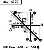
Runways
Runway Summary
| Runways: | 08/26 12/30 17/35 H1 H2 |
| Longest Runway: | 12/30 is 7498 ft (2285 m) long |
| Runways with an Instrument Approach: | 17 |
BIH Airport Runway Details
| Runway 08/26 | 5567 ft x 100 ft (1697 m x 30 m) | |
| Runway Length Source: | 3RD PARTY SURVEY as of 07/09/2008 | |
| Surface: | Asphalt - Fair condition - No special surface treatment | |
| Runway Pavement Class: | 25 /F/A/W/T | |
| Runway Edge Lights: | Medium Intensity | |
Runway Weight Bearing Capacity (in thousands of pounds) |
||
| Single Wheel Landing Gear: | 40.0 | |
| Dual Wheel Landing Gear: | 56.0 | |
| Dual Tandem Wheel Landing Gear: | 98.0 | |
Runway 08 |
Runway 26 |
|
Elevation: |
4124.1 | 4100.3 |
Latitude: |
37-22-25.1389N | 37-22-24.6629N |
Longitude: |
118-22-26.8872W | 118-21-17.9344W |
|
Runway True Alignment: |
090 | 270 |
Glide Path Angle: |
3.5 degrees | 3.0 degrees |
Traffic Pattern: |
Left | Left |
Runway Markings Type: |
Nonprecision Instrument | Nonprecision Instrument |
Runway Markings Condition: |
Good | Good |
Object at End: |
TREES | |
Object Height: |
47 | |
Distance from End: |
1350 | |
Object Centerline Offset: |
130 ft. left of centerline | |
Visual Glide Slope Indicators: |
2-Light PAPI On Left Side Of Runway | 2-Light PAPI On Left Side Of Runway |
REIL: |
No | No |
Touchdown Lights: |
No | No |
Centerline Lights: |
No | No |
Threshold Crossing Height: |
30 | 25 |
| Runway 12/30 | 7498 ft x 100 ft (2285 m x 30 m) | |
| Runway Length Source: | 3RD PARTY SURVEY as of 07/09/2008 | |
| Surface: | Asphalt - Fair condition - Porous friction course | |
| Runway Pavement Class: | 50 /F/B/W/T | |
| Runway Edge Lights: | Medium Intensity | |
Runway Weight Bearing Capacity (in thousands of pounds) |
||
| Single Wheel Landing Gear: | 70.0 | |
| Dual Wheel Landing Gear: | 110.0 | |
| Dual Tandem Wheel Landing Gear: | 200.0 | |
Runway 12 |
Runway 30 |
|
Elevation: |
4122.6 | 4100.0 |
Latitude: |
37-22-48.5093N | 37-21-55.6498N |
Longitude: |
118-22-24.0154W | 118-21-18.9141W |
|
Runway True Alignment: |
135 | 315 |
Glide Path Angle: |
3.0 degrees | 3.5 degrees |
Traffic Pattern: |
Left | Left |
Runway Markings Type: |
Nonprecision Instrument | Nonprecision Instrument |
Runway Markings Condition: |
Good | Good |
Object at End: |
PLINE | |
Object Height: |
35 | |
Distance from End: |
1555 | |
Object Centerline Offset: |
130 ft. left of centerline | |
Visual Glide Slope Indicators: |
4-Light PAPI On Left Side Of Runway | 4-Light PAPI On Left Side Of Runway |
REIL: |
Yes | Yes |
Touchdown Lights: |
No | No |
Centerline Lights: |
No | No |
Threshold Crossing Height: |
48 | 52 |
Declared Distances |
||
Take Off Run Avbl. (TORA): |
7498 | 7498 |
Take Off Distance Avbl. (TODA): |
7498 | 7498 |
Actual Stop Dist. Avbl. (ASDA): |
7098 | 6743 |
Landing Dist. Avbl. (LDA): |
7098 | 6743 |
| Runway 17/35 | 5600 ft x 100 ft (1707 m x 30 m) | |
| Runway Length Source: | 3RD PARTY SURVEY as of 07/09/2008 | |
| Surface: | Asphalt - Fair condition - Porous friction course | |
| Runway Pavement Class: | 49 /F/B/W/T | |
| Runway Edge Lights: | Medium Intensity | |
Runway Weight Bearing Capacity (in thousands of pounds) |
||
| Single Wheel Landing Gear: | 100.0 | |
| Dual Wheel Landing Gear: | 140.0 | |
| Dual Tandem Wheel Landing Gear: | 240.0 | |
Runway 17 |
Runway 35 |
|
Elevation: |
4112.5 | 4104.9 |
Latitude: |
37-22-50.6424N | 37-21-55.2910N |
Longitude: |
118-21-41.9001W | 118-21-42.4951W |
|
Runway True Alignment: |
180 | 000 |
ILS Type: |
LDA/DME | |
Glide Path Angle: |
3.5 degrees | 3.0 degrees |
Traffic Pattern: |
Left | Left |
Runway Markings Type: |
Nonprecision Instrument | Nonprecision Instrument |
Runway Markings Condition: |
Good | Good |
Object at End: |
TREES | |
Object Height: |
30 | |
Distance from End: |
1442 | |
Object Centerline Offset: |
130 ft. left of centerline | |
Visual Glide Slope Indicators: |
4-Light PAPI On Left Side Of Runway | 4-Light PAPI On Left Side Of Runway |
REIL: |
Yes | Yes |
Touchdown Lights: |
No | No |
Centerline Lights: |
No | No |
Threshold Crossing Height: |
50 | 50 |
| Helipad H1 | 40 ft x 40 ft (12 m x 12 m) | |
| Surface: | Asphalt - Fair condition - No special surface treatment | |
Helipad H1 |
||
Glide Path Angle: |
0.0 degrees | 0.0 degrees |
Object Centerline Offset: |
130 ft. left of centerline |
| Helipad H2 | 100 ft x 100 ft (30 m x 30 m) | |
| Surface: | Asphalt - Fair condition - No special surface treatment | |
Helipad H2 |
||
Glide Path Angle: |
0.0 degrees | 0.0 degrees |
Object Centerline Offset: |
130 ft. left of centerline |
Services
Airframe Repair: |
None |
Powerplant Repair: |
None |
Bottled Oxygen: |
None |
Bulk Oxygen: |
None |
Fuel Available: |
100LL |
Landing Fees: |
No |
Parking: |
Tiedowns available |
Maps & Diagrams
BIH Sectional
Flight Planning
at skyvector.com
at skyvector.com