Location
Latitude: |
62-38-50.4000N (62.647333) |
Longitude: |
160-11-24.2000W (-160.190056) |
Elevation: |
297.3 feet MSL (91 m MSL) |
Magnetic Variation: |
10.5 E (as of April 2024 from WMM2020 model) |
Time Zone: |
UTC -9.0 (Standard Time) UTC -8.0 (Daylight Savings Time) |
From City: |
01 N.M. SE of Anvik, Alaska |
Found On: |
Mc Grath Chart |
FAA Region: |
AAL |
Contacts
Manager: |
Publicly owned: |
| ERIK WEINGARTH BOX 135 ST MARY'S, AK 99658 907-438-2416 |
ALASKA DOT&PF NORTHERN REGION 2301 PEGER ROAD FAIRBANKS, AK 99709 907-451-2200 |
Operations
Airport Status: |
Operational |
Facility Use: |
Public |
Type: |
Airport |
Activation Date: |
06/1963 |
Control tower: |
No |
Attendance (Months/Days/Hours): |
Months/Days/Hours Unattended |
Boundary ARTCC: |
ZAN (Anchorage) |
Responsible ARTCC: |
ZAN (Anchorage) |
Lighting Schedule: |
SEE RMK |
Segmented Circle Indicator: |
Yes |
Traffic Pattern Altitude (MSL): |
1297 feet (395 m) |
NOTAMs Facility: |
ANV |
NOTAM-D Service: |
Yes |
Military Landing Rights: |
Yes |
Based Aircraft
Annual Operations (as of 12/31/2022)
| Total Operations: | 1000 | |
| Air Taxi: | 1000 | 100.0% |
Communications
| CTAF: | 122.700 |
| Unicom: | 122.700 |
| AWOS-3P: | 133.55 (907-663-6353) |
- APCH/DEP SVC PRVDD BY ANCHORAGE ARTCC ON FREQS 135.7/335.5 (UNALAKLEET RCAG).
- COMMUNICATIONS PRVDD BY KENAI FSS ON FREQ 122.4 (ANVIK RCO).
Fixed Based Operators (FBOs) & Fuel
(Click on a business for detail)
Please help us keep this information up to date. This is a FREE SERVICE just like everything else on Airport Guide! If you see that a business needs to be added, modified, or deleted please fill out our Update Form.
To add, modify, or delete a business click here.
Please help us keep this information up to date. This is a FREE SERVICE just like everything else on Airport Guide! If you see that a business needs to be added, modified, or deleted please fill out our Update Form.
Area Code: 907 |
| Business Name | Frequency | Phone | Fuel Grade |
|---|
Flight Service Stations
| Primary | Alternate | |
| FSS on Field: | ||
| FSS Name (ID): | Kenai(ENA) | |
| Frequency: | ||
| Toll Free Phone: | 1-866-864-1737 |
Instrument Procedures / Charts
FAA Terminal Procedures valid from 0901Z 03/21/24 to 0901Z 04/18/24.
There are various types of charts available for an airport. They are listed in the Page Type column. Here is a legend for those types:
APD - Airport Diagram
DP - Departure Procedure Charts
HOT - Hot Spots
IAP - Instrument Approach Procedure Charts
MIN - Minimums
STAR - Standard Terminal Arrival Charts
| Page Type | Page Name | Volume | Action Since Last Cycle |
|---|---|---|---|
| IAP | RNAV (GPS) RWY 17 | AK-1 | Changed |
| IAP | RNAV (GPS) RWY 35 | AK-1 | Changed |
| MIN | ALTERNATE MINIMUMS | AK-1 | |
| MIN | TAKEOFF MINIMUMS | AK-1 |
Terminal Procedures are only available for airports in several countries with more being added all the time. If you are looking for a specific country's charts, please send an email to support(at)airportguide.com stating the country name. This will be used to prioritize the implementation.
Navigation Aids (Navaids) near ANV
| Dist (NM) | ID | Morse Code | Name | Type | Freq | True Hdg | Mag Hdg |
|---|---|---|---|---|---|---|---|
| 0.4 | ANV | . _ _ . . . . _ | Anvik | NDB | 365 | 159 | 149 |
| 65.6 | ANI | . _ _ . . . | Aniak | NDB | 359 | 165 | 154 |
| 75.9 | UNK | . . _ _ . _ . _ | Unalakleet | VOR-DME | 116.90 | 350 | 340 |
| 77.5 | JNR | . _ _ _ _ . . _ . | North River | NDB | 382 | 347 | 337 |
| 93.0 | SMA | . . . _ _ . _ | St Marys | NDB | 230 | 249 | 239 |
Nearby Airports with Fuel
| Dist (NM) | Name (Airport IDs) | True Hdg | Mag Hdg | Fuel Grade |
|---|---|---|---|---|
| 66.5 | Aniak Airport (ANI PANI ANI) |
163 | 152 | 100LL, Jet A |
| 73.8 | Crooked Creek Airport (CKD CJX) |
128 | 117 | MOGAS |
Notices to Airmen (NOTAMS)
Remarks
| A110-3 | RY COND NOT MONITORED; RCMD VISUAL INSPECTION PRIOR TO LNDG. |
| A110-4 | WX CAMERA AVBL ON INTERNET AT HTTPS://WEATHERCAMS.FAA.GOV |
| A110-5 | RADIO AIDS TO NAVIGATION - NDB/DME OTS INDEF |
| A81-APT | ACTVT MIRL RY 17/35, PAPIS RWY 17 &35, REILS RWY 17& 35 --122.7. |
| A83 | 77 FT TREES 200 FT EAST OF WINDSOCK MAY RESULT IN ERRONEOUS WIND INDICATIONS. |
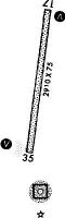
Runways
Runway Summary
| Runways: | 17/35 |
| Longest Runway: | 17/35 is 4000 ft (1219 m) long |
| Runways with an Instrument Approach: |
ANV Airport Runway Details
| Runway 17/35 | 4000 ft x 75 ft (1219 m x 23 m) | |
| Runway Length Source: | 3RD PARTY SURVEY as of 06/08/2012 | |
| Surface: | Gravel - Good condition - No special surface treatment | |
| Runway Edge Lights: | Medium Intensity | |
Runway 17 |
Runway 35 |
|
Elevation: |
290.4 | 297.3 |
Latitude: |
62-39-09.9486N | 62-38-30.8129N |
Longitude: |
160-11-19.4797W | 160-11-28.9817W |
|
Runway True Alignment: |
186 | 006 |
Glide Path Angle: |
3.0 degrees | 3.0 degrees |
Traffic Pattern: |
Left | Left |
Object at End: |
BRUSH | BRUSH |
Object Height: |
7 | 10 |
Distance from End: |
0 | 0 |
Object Centerline Offset: |
135 ft. right of centerline | 245 ft. left of centerline |
Visual Glide Slope Indicators: |
4-Light PAPI On Left Side Of Runway | 4-Light PAPI On Left Side Of Runway |
REIL: |
Yes | Yes |
Threshold Crossing Height: |
25 | 25 |
Services
Fuel Available: |
MOGAS |
Landing Fees: |
No |
Maps & Diagrams
ANV Sectional
Flight Planning
at skyvector.com
at skyvector.com