Location
Latitude: |
40-26-34.3260N (40.442868) |
Longitude: |
076-26-29.8580W (-76.441627) |
Elevation: |
495.0 feet MSL (151 m MSL) |
Magnetic Variation: |
11.3 W (as of April 2024 from WMM2020 model) |
Time Zone: |
UTC -5.0 (Standard Time) UTC -4.0 (Daylight Savings Time) |
From City: |
00 N.M. W of Fredericksburg, Pennsylvania |
Found On: |
New York Chart |
FAA Region: |
AEA |
Contacts
Manager: |
Privately owned: |
| ALLETTA M. SCHADLER 151 AIRPORT ROAD FREDERICKSBURG, PA 17026 (717) 507-0303 |
FARMERS PRIDE AIRPORT LLC 215 W. MAIN ST. FREDERICKSBURG, PA 17026 717-865-4596 |
Operations
Airport Status: |
Operational |
Facility Use: |
Public |
Type: |
Airport |
Activation Date: |
11/1947 |
Control tower: |
No |
Attendance (Months/Days/Hours): |
Months/Days/Hours ALL/ALL/0900-1700 |
Boundary ARTCC: |
ZNY (New York) |
Responsible ARTCC: |
ZNY (New York) |
Lighting Schedule: |
SEE RMK |
Segmented Circle Indicator: |
No |
Traffic Pattern Altitude (MSL): |
1495 feet (456 m) |
NOTAMs Facility: |
IPT |
NOTAM-D Service: |
Yes |
International Airport of Entry: |
No |
Customs Landing Rights: |
No |
Based Aircraft
| Single Engine: | 50 |
| Ultralights: | 3 |
Annual Operations (as of 08/22/2023)
| Total Operations: | 8125 | |
| GA Local: | 6500 | 80.0% |
| GA Itinerant: | 1600 | 19.7% |
| Military Aircraft: | 25 | 0.3% |
Communications
| CTAF: | 122.900 |
Fixed Based Operators (FBOs) & Fuel
(Click on a business for detail)
Please help us keep this information up to date. This is a FREE SERVICE just like everything else on Airport Guide! If you see that a business needs to be added, modified, or deleted please fill out our Update Form.
To add, modify, or delete a business click here.
Please help us keep this information up to date. This is a FREE SERVICE just like everything else on Airport Guide! If you see that a business needs to be added, modified, or deleted please fill out our Update Form.
Area Code: 717 |
| Business Name | Frequency | Phone | Fuel Grade |
|---|
Flight Service Stations
| Primary | Alternate | |
| FSS on Field: | N | |
| FSS Name (ID): | Williamsport(IPT) | |
| Frequency: | ||
| Toll Free Phone: | 1-800-WX-BRIEF |
Instrument Procedures / Charts
Terminal Procedures are only available for airports in several countries with more being added all the time. If you are looking for a specific country's charts, please send an email to support(at)airportguide.com stating the country name. This will be used to prioritize the implementation.
Navigation Aids (Navaids) near 9N7
| Dist (NM) | ID | Morse Code | Name | Type | Freq | True Hdg | Mag Hdg |
|---|---|---|---|---|---|---|---|
| 5.1 | BZJ | _ . . . _ _ . . . _ _ _ | Bellgrove | NDB | 328 | 265 | 276 |
| 9.8 | RAV | . _ . . _ . . . _ | Ravine | VORTAC | 114.60 | 312 | 323 |
| 20.6 | LRP | . _ . . . _ . . _ _ . | Lancaster | VOR-DME | 117.30 | 160 | 171 |
| 20.8 | MDT | _ _ _ . . _ | Harrisburg | VOT | 110.00 | 225 | 236 |
| 24.1 | MD | _ _ _ . . | Enola | NDB | 204 | 240 | 251 |
| 29.0 | SEG | . . . . _ _ . | Selinsgrove | VOR-DME | 110.40 | 316 | 327 |
| 29.9 | HAR | . . . . . _ . _ . | Harrisburg | VORTAC | 112.50 | 253 | 264 |
| 30.3 | CX | _ . _ . _ . . _ | Latle | NDB | 219 | 238 | 249 |
| 35.0 | HZL | . . . . _ _ . . . _ . . | Hazleton | VOR | 109.40 | 24 | 35 |
| 35.5 | ETX | . _ _ . . _ | East Texas | VOR-DME | 110.20 | 76 | 88 |
| 36.3 | MIP | _ _ . . . _ _ . | Milton | VORTAC | 109.20 | 343 | 354 |
| 37.2 | EUD | . . . _ _ . . | York | NDB | 254 | 212 | 223 |
| 42.4 | PTW | . _ _ . _ . _ _ | Pottstown | VORTAC | 116.50 | 107 | 119 |
| 47.3 | MXE | _ _ _ . . _ . | Modena | VORTAC | 113.20 | 131 | 142 |
| 48.1 | FJC | . . _ . . _ _ _ _ . _ . | Allentown | VORTAC | 117.50 | 68 | 80 |
| 51.5 | PIX | . _ _ . . . _ . . _ | Picture Rocks | NDB | 344 | 346 | 357 |
| 52.3 | UKT | . . _ _ . _ _ | Quakertown | NDB | 208 | 90 | 102 |
| 55.8 | FQM | . . _ . _ _ . _ _ _ | Williamsport | VOR-DME | 114.40 | 344 | 355 |
| 56.2 | ING | . . _ . _ _ . | Ambler | NDB | 275 | 109 | 121 |
| 56.6 | APG | . _ . _ _ . _ _ . | Aberdeen | NDB | 349 | 164 | 175 |
Nearby Airports with Fuel
Notices to Airmen (NOTAMS)
Remarks
| A110-3 | ORANGE 6 FT TETRAHEDRON NEXT TO THE WINDSOCK ON THE S SIDE OF RWY. |
| A110-4 | DSPLCD THLD LGTS - 3 GREEN LANDING, 1 GREEN ROLL-OUT. |
| A110-5 | FOR CD CTC HARRISBURG APCH AT 800-932-0712. |
| A16 | CELL PHONE 717-507-0303. |
| A42-10 | RY 10 /28 TURF RY MKD BY YELLOW TIRES/WHITE LGTS. |
| A51-10 | DSPLCD THLDS MKD BY 6 SPLIT RED/GREEN LGTS. |
| A51-28 | RY 28 DSPLCD THLDS MKD BY 6 SPLIT RED/GREEN LGTS. |
| A57-10 | RWY 10 APCH RATIO 20:1 TO DTHR. |
| A57-28 | RWY 28 APCH RATIO 21:1 TO DTHR. |
| A70-FUEL-10 | 0LL ONLY FUEL AVBL TO TSNT ACFT IS EMERG FUEL. |
| A81-APT | ACTVT LIRL RWY 10/28 ON CTAF - 122.9. |
| A81-BCN | ACTVT RTG BCN CTAF - 122.9. |
Runways
Runway Summary
| Runways: | 10/28 |
| Longest Runway: | 10/28 is 3410 ft (1039 m) long |
| Runways with an Instrument Approach: |
9N7 Airport Runway Details
| Runway 10/28 | 3410 ft x 150 ft (1039 m x 46 m) | |
| Surface: | Turf - Good condition - No special surface treatment | |
| Runway Edge Lights: | Non-standard lighting system Intensity | |
Runway 10 |
Runway 28 |
|
Glide Path Angle: |
0.0 degrees | 0.0 degrees |
Traffic Pattern: |
Left | Left |
Object at End: |
TREE | TREE |
Object Height: |
33 | 29 |
Distance from End: |
236 | 57 |
Object Centerline Offset: |
130 ft. left of centerline | 122 ft. left of centerline |
Displaced Threshold: |
504 | 590 |
Services
Airframe Repair: |
Major |
Powerplant Repair: |
Major |
Bottled Oxygen: |
None |
Bulk Oxygen: |
None |
Fuel Available: |
100LL, Jet A |
Landing Fees: |
Yes |
Parking: |
Hangars and tiedowns available |
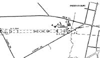
Maps & Diagrams
9N7 Sectional
Flight Planning
at skyvector.com
at skyvector.com