Location
Latitude: |
43-13-18.4087N (43.22178) |
Longitude: |
099-24-12.3223W (-99.403423) |
Elevation: |
2174.5 feet MSL (663 m MSL) |
Magnetic Variation: |
4.5 E (as of April 2024 from WMM2020 model) |
Time Zone: |
UTC -6.0 (Standard Time) UTC -5.0 (Daylight Savings Time) |
From City: |
01 N.M. SE of Gregory, South Dakota |
Found On: |
Omaha Chart |
FAA Region: |
AGL |
Contacts
Manager: |
Publicly owned: |
| JOSEY LARSON 120 W 6TH ST GREGORY, SD 57533 605-830-5750 |
CITY OF GREGORY 120 W 6TH ST GREGORY, SD 05753 605-835-8270 |
Operations
Airport Status: |
Operational |
Facility Use: |
Public |
Type: |
Airport |
Activation Date: |
12/1949 |
Control tower: |
No |
Attendance (Months/Days/Hours): |
Months/Days/Hours ALL/ALL/DAWN-DUSK |
Boundary ARTCC: |
ZMP (Minneapolis) |
Responsible ARTCC: |
ZMP (Minneapolis) |
Lighting Schedule: |
SEE RMK |
Segmented Circle Indicator: |
No |
Traffic Pattern Altitude (MSL): |
3174 feet (967 m) |
NOTAMs Facility: |
HON |
NOTAM-D Service: |
Yes |
International Airport of Entry: |
No |
Customs Landing Rights: |
No |
Military Landing Rights: |
No |
Civil/Military Joint Use: |
No |
Based Aircraft
| Single Engine: | 12 |
| GA Helicopters: | 1 |
Annual Operations (as of 06/05/2023)
| Total Operations: | 3090 | |
| Air Taxi: | 200 | 6.5% |
| GA Local: | 2090 | 67.6% |
| GA Itinerant: | 800 | 25.9% |
Communications
| CTAF: | 122.800 |
| Unicom: | 122.800 |
- APCH/DEP SVC PRVDD BY MINNEAPOLIS ARTCC (ZMP) ON FREQ 125.1/269.1 (PIERRE RCAG).
Fixed Based Operators (FBOs) & Fuel
(Click on a business for detail)
Please help us keep this information up to date. This is a FREE SERVICE just like everything else on Airport Guide! If you see that a business needs to be added, modified, or deleted please fill out our Update Form.
To add, modify, or delete a business click here.
Please help us keep this information up to date. This is a FREE SERVICE just like everything else on Airport Guide! If you see that a business needs to be added, modified, or deleted please fill out our Update Form.
Area Code: 605 |
| Business Name | Frequency | Phone | Fuel Grade |
|---|---|---|---|
| Rosebud Aviation
Update FBO info |
Unicom 122.8 | 835-9978 | 100LL, Jet A |
Flight Service Stations
| Primary | Alternate | |
| FSS on Field: | N | |
| FSS Name (ID): | Huron(HON) | |
| Frequency: | ||
| Toll Free Phone: | 1-800-WX-BRIEF |
Instrument Procedures / Charts
FAA Terminal Procedures valid from 0901Z 03/21/24 to 0901Z 04/18/24.
There are various types of charts available for an airport. They are listed in the Page Type column. Here is a legend for those types:
APD - Airport Diagram
DP - Departure Procedure Charts
HOT - Hot Spots
IAP - Instrument Approach Procedure Charts
MIN - Minimums
STAR - Standard Terminal Arrival Charts
| Page Type | Page Name | Volume | Action Since Last Cycle |
|---|---|---|---|
| IAP | RNAV (GPS) RWY 13 | NC-1 | |
| IAP | RNAV (GPS) RWY 31 | NC-1 | |
| MIN | TAKEOFF MINIMUMS | NC-1 |
Terminal Procedures are only available for airports in several countries with more being added all the time. If you are looking for a specific country's charts, please send an email to support(at)airportguide.com stating the country name. This will be used to prioritize the implementation.
Navigation Aids (Navaids) near 9D1
| Dist (NM) | ID | Morse Code | Name | Type | Freq | True Hdg | Mag Hdg |
|---|---|---|---|---|---|---|---|
| 22.3 | ISD | . . . . . _ . . | Winner | VOR | 112.80 | 315 | 310 |
| 39.6 | RBE | . _ . _ . . . . | Rock County | NDB | 341 | 191 | 186 |
| 46.9 | ANW | . _ _ . . _ _ | Ainsworth | VOR-DME | 112.70 | 213 | 208 |
| 49.5 | AGZ | . _ _ _ . _ _ . . | Wagner | NDB | 392 | 100 | 96 |
| 54.7 | VTN | . . . _ _ _ . | Valentine | NDB | 314 | 247 | 242 |
| 55.0 | ONL | _ _ _ _ . . _ . . | O'neill | VORTAC | 113.90 | 144 | 140 |
| 68.1 | MHE | _ _ . . . . . | Mitchell | VOR-DME | 109.20 | 60 | 56 |
| 77.7 | PIR | . _ _ . . . . _ . | Pierre | VORTAC | 113.75 | 335 | 330 |
| 86.6 | HO | . . . . _ _ _ | Beady | NDB | 302 | 31 | 27 |
| 87.1 | HON | . . . . _ _ _ _ . | Huron | DME | 117.6 | 32 | 28 |
| 87.6 | BUB | _ . . . . . _ _ . . . | Burwell | NDB | 377 | 172 | 168 |
| 90.3 | YKN | _ . _ _ _ . _ _ . | Yankton | DME | 111.4 | 100 | 96 |
| 94.4 | TDD | _ _ . . _ . . | Thedford | VOR-DME | 108.60 | 218 | 213 |
| 94.9 | YK | _ . _ _ _ . _ | Cagur | NDB | 347 | 103 | 99 |
| 98.0 | ODX | _ _ _ _ . . _ . . _ | Ord | NDB | 356 | 167 | 163 |
Nearby Airports with Fuel
| Dist (NM) | Name (Airport IDs) | True Hdg | Mag Hdg | Fuel Grade |
|---|---|---|---|---|
| 27.3 | Platte Municipal Airport (1D3) |
66 | 62 | 100LL |
| 32.9 | Chamberlain Municipal Airport (9V9) |
6 | 2 | 100LL, Jet A |
| 46.5 | Ainsworth Regional Airport (ANW KANW ANW) |
214 | 209 | 100LL, Jet A |
| 49.4 | Wagner Municipal Airport (KAGZ AGZ) |
100 | 96 | 100LL |
| 54.8 | Miller Field Airport (VTN KVTN VTN) |
246 | 241 | 100LL, Jet A |
| 55.0 | The O'neill Municipal-John L Baker Field Airport (ONL KONL ONL) |
144 | 140 | 100LL, Jet A+ |
| 68.0 | Mitchell Municipal Airport (MHE KMHE MHE) |
60 | 56 | 100LL, Jet A |
| 79.4 | Pierre Regional Airport (PIR KPIR PIR) |
331 | 326 | 100LL, Jet A |
| 80.5 | Miller Municipal Airport (KMKA MKA) |
13 | 9 | 100LL |
| 86.4 | Huron Regional Airport (HON KHON HON) |
35 | 31 | 100LL, Jet A |
| 89.7 | Antelope County Airport (4V9) |
137 | 133 | 100LL |
| 90.3 | Chan Gurney Municipal Airport (YKN KYKN YKN) |
101 | 98 | 100LL, Jet A |
| 91.5 | Thomas County Airport (KTIF TIF) |
214 | 209 | 100LL, Jet A |
| 95.3 | Sargent Municipal Airport (09K) |
178 | 174 | 100, 100LL |
| 97.9 | Evelyn Sharp Field Airport (KODX ODX) |
168 | 164 | 100LL |
Notices to Airmen (NOTAMS)
Remarks
| A110-1 | TELEPHONE AVBL. |
| A110-2 | GCO AVBL ON FREQ 121.725 (4 CLICKS TO MINNEAPOLIS CENTER) |
| A110-3 | FOR CD IF UNA VIA GCO CTC MINNEAPOLIS ARTCC AT 651-463-5588. |
| A52-13 | CONC PLANT LOCATED APROPLY 1282 FT OFF END OF RWY 31. |
| A81-APT | ACTVT MIRL RY 13/31 & PAPI RYS 13 & 31 - CTAF. |
| A82 | AUTOMATED UNICOM. |
Runways
Runway Summary
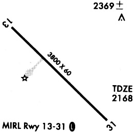
| Runways: | 13/31 |
| Longest Runway: | 13/31 is 3799 ft (1158 m) long |
| Runways with an Instrument Approach: |
9D1 Airport Runway Details
| Runway 13/31 | 3799 ft x 60 ft (1158 m x 18 m) | |
| Runway Length Source: | 3RD PARTY SURVEY as of 09/10/2009 | |
| Surface: | Asphalt - Excellent condition - No special surface treatment | |
| Runway Edge Lights: | Medium Intensity | |
Runway Weight Bearing Capacity (in thousands of pounds) |
||
| Single Wheel Landing Gear: | 12.5 | |
Runway 13 |
Runway 31 |
|
Elevation: |
2169.7 | 2159.9 |
Latitude: |
43-13-29.8080N | 43-13-03.4995N |
Longitude: |
099-24-29.2576W | 099-23-52.6813W |
|
Runway True Alignment: |
135 | 315 |
Glide Path Angle: |
3.0 degrees | 3.0 degrees |
Traffic Pattern: |
Left | Left |
Runway Markings Type: |
Nonprecision Instrument | Nonprecision Instrument |
Runway Markings Condition: |
Good | Good |
Object at End: |
OTHER | |
Object Height: |
38 | |
Object Marked/Lighted?: |
Lighted | |
Distance from End: |
1282 | |
Object Centerline Offset: |
25 ft. right of centerline | |
Visual Glide Slope Indicators: |
2-Light PAPI On Left Side Of Runway | 2-Light PAPI On Left Side Of Runway |
REIL: |
No | No |
Touchdown Lights: |
No | No |
Centerline Lights: |
No | No |
Threshold Crossing Height: |
31 | 32 |
Services
Bottled Oxygen: |
None |
Bulk Oxygen: |
None |
Fuel Available: |
100LL |
Landing Fees: |
No |
Parking: |
Hangars and tiedowns available |
Maps & Diagrams
9D1 Sectional
Flight Planning
at skyvector.com
at skyvector.com