Location
Latitude: |
45-25-29.4000N (45.424833) |
Longitude: |
117-15-53.1000W (-117.26475) |
Elevation: |
3957.0 feet MSL (1206 m MSL) |
Magnetic Variation: |
13.5 E (as of April 2024 from WMM2020 model) |
Time Zone: |
UTC -8.0 (Standard Time) UTC -7.0 (Daylight Savings Time) |
From City: |
00 N.M. E of Enterprise, Oregon |
Found On: |
Seattle Chart |
FAA Region: |
ANM |
Contacts
Manager: |
Publicly owned: |
| JOE SPENCE P O BOX 217 ENTERPRISE, OR 97828 541-426-3288 |
CITY OF ENTERPRISE 108 NE 1ST ST ENTERPRISE, OR 97828 541-426-4196 |
Operations
Airport Status: |
Operational |
Facility Use: |
Public |
Type: |
Airport |
Activation Date: |
01/1961 |
Control tower: |
No |
Attendance (Months/Days/Hours): |
Months/Days/Hours ALL/ALL/ON CALL |
Boundary ARTCC: |
ZSE (Seattle) |
Responsible ARTCC: |
ZSE (Seattle) |
Lighting Schedule: |
SS-SR |
Segmented Circle Indicator: |
Yes |
Traffic Pattern Altitude (MSL): |
4957 feet (1511 m) |
NOTAMs Facility: |
MMV |
NOTAM-D Service: |
Yes |
International Airport of Entry: |
No |
Customs Landing Rights: |
No |
Military Landing Rights: |
No |
Civil/Military Joint Use: |
No |
Based Aircraft
| Single Engine: | 27 |
| Ultralights: | 4 |
Annual Operations (as of 08/28/2018)
| Total Operations: | 4850 | |
| Air Taxi: | 450 | 9.3% |
| GA Local: | 1000 | 20.6% |
| GA Itinerant: | 3400 | 70.1% |
Communications
| CTAF: | 122.800 |
| Unicom: | 122.800 |
Fixed Based Operators (FBOs) & Fuel
(Click on a business for detail)
Please help us keep this information up to date. This is a FREE SERVICE just like everything else on Airport Guide! If you see that a business needs to be added, modified, or deleted please fill out our Update Form.
To add, modify, or delete a business click here.
Please help us keep this information up to date. This is a FREE SERVICE just like everything else on Airport Guide! If you see that a business needs to be added, modified, or deleted please fill out our Update Form.
Area Code: 541 |
| Business Name | Frequency | Phone | Fuel Grade |
|---|---|---|---|
| D&M Aviation
Update FBO info |
426-4894 | ||
| Spence's Flight Service
Update FBO info |
Unicom 122.8 | 426-3562 | 100LL |

|
 Texaco |
100LL - 4.80 USD per gallon on 07/16/2021 |
Pumps requiring line service |
| Stangels Service
Update FBO info |
426-3562 | 100LL |
Flight Service Stations
| Primary | Alternate | |
| FSS on Field: | N | |
| FSS Name (ID): | Mc Minnville(MMV) | |
| Frequency: | ||
| Toll Free Phone: | 1-800-WX-BRIEF |
Instrument Procedures / Charts
Terminal Procedures are only available for airports in several countries with more being added all the time. If you are looking for a specific country's charts, please send an email to support(at)airportguide.com stating the country name. This will be used to prioritize the implementation.
Navigation Aids (Navaids) near 8S4
| Dist (NM) | ID | Morse Code | Name | Type | Freq | True Hdg | Mag Hdg |
|---|---|---|---|---|---|---|---|
| 29.8 | LGD | . _ . . _ _ . _ . . | La Grande | NDB | 296 | 260 | 246 |
| 41.9 | BKE | _ . . . _ . _ . | Baker City | VOR-DME | 115.30 | 213 | 199 |
| 51.0 | IDQ | . . _ . . _ _ . _ | Cottonwood | DME | 115.65 | 40 | 27 |
| 58.6 | ALW | . _ . _ . . . _ _ | Walla Walla | VOR-DME | 116.40 | 313 | 299 |
| 59.6 | AL | . _ . _ . . | Trina | NDB | 353 | 319 | 305 |
| 59.7 | DNJ | _ . . _ . . _ _ _ | Donnelly | VOR-DME | 116.20 | 130 | 117 |
| 59.7 | MQG | _ _ _ _ . _ _ _ . | Nez Perce | VOR-DME | 114.45 | 15 | 1 |
| 63.7 | PD | . _ _ . _ . . | Foris | NDB | 230 | 285 | 271 |
| 72.2 | PDT | . _ _ . _ . . _ | Pendleton | VORTAC | 114.70 | 283 | 269 |
| 75.0 | PUW | . _ _ . . . _ . _ _ | Pullman | VOR-DME | 117.15 | 1 | 347 |
| 85.0 | ONO | _ _ _ _ . _ _ _ | Ontario | NDB | 305 | 172 | 159 |
| 92.6 | PSC | . _ _ . . . . _ . _ . | Pasco | VOR-DME | 113.75 | 303 | 289 |
Nearby Airports with Fuel
Notices to Airmen (NOTAMS)
Remarks
| A110-1 | |
| A110-2 | UNLIGHTED HELIPAD 150 FT SE OF ROTG BCN ADJ TO TWY. |
| A110-3 | PARALLEL TWY 20 FT WIDE; LOOSE GRVL ON SURFACE. |
| A110-4 | BE ALERT; SOFT EDGES AND STEEP SHOULDERS ALONG RY & TWY. |
| A110-5 | 65 FT LGTD CELL TWR LOCATED 200 FT SW OF RY 12. |
| A17 | FOR ATTENDANT CALL 541-426-3562. |
| A42-12 | RY 12/30 NSTD BSC MARKINGS; NUMBERS SMALL. |
| A58-12 | HAS 3 FT FENCE 50 FT FM THLD 60 FT L OF CNTRLN. |
| A58-30 | HAS 4 FT FENCE 108 FT R AT END. |
| A70-FUEL-10 | 0LL FOR FUEL CALL 541-426-3288. |
Runways
Runway Summary
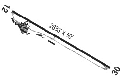
| Runways: | 12/30 |
| Longest Runway: | 12/30 is 2850 ft (869 m) long |
| Runways with an Instrument Approach: |
8S4 Airport Runway Details
| Runway 12/30 | 2850 ft x 50 ft (869 m x 15 m) | |
| Surface: | Asphalt - Fair condition - No special surface treatment | |
| Runway Edge Lights: | Low Intensity | |
Runway Weight Bearing Capacity (in thousands of pounds) |
||
| Single Wheel Landing Gear: | 7.0 | |
Runway 12 |
Runway 30 |
|
Elevation: |
3910.0 | 3954.0 |
Latitude: |
45-25-39.9129N | 45-25-18.9408N |
Longitude: |
117-16-06.3861W | 117-15-39.7305W |
|
Runway True Alignment: |
138 | 318 |
Glide Path Angle: |
0.0 degrees | 0.0 degrees |
Traffic Pattern: |
Left | Left |
Runway Markings Type: |
Nonstandard (other than numbers only) | Nonstandard (other than numbers only) |
Runway Markings Condition: |
Fair | Fair |
Services
Airframe Repair: |
None |
Powerplant Repair: |
None |
Bottled Oxygen: |
None |
Bulk Oxygen: |
None |
Fuel Available: |
100LL, Jet A+ |
Landing Fees: |
No |
Parking: |
Tiedowns available |
Maps & Diagrams
8S4 Sectional
Flight Planning
at skyvector.com
at skyvector.com