Location
Latitude: |
43-15-17.5600N (43.254878) |
Longitude: |
078-45-55.8000W (-78.7655) |
Elevation: |
360.0 feet MSL (110 m MSL) |
Magnetic Variation: |
10.5 W (as of April 2024 from WMM2020 model) |
Time Zone: |
UTC -5.0 (Standard Time) UTC -4.0 (Daylight Savings Time) |
From City: |
03 N.M. SW of Newfane, New York |
Found On: |
Detroit Chart |
FAA Region: |
AEA |
Contacts
Manager: |
Privately owned: |
| AL C. HOLLANDS 76 LANCASTER AV BUFFALO, NY 14222 716-536-8653 |
AL C. HOLLANDS 76 LANCASTER AV BUFFALO, NY 14222 716-536-8653 |
Operations
Airport Status: |
Operational |
Facility Use: |
Public |
Type: |
Airport |
Activation Date: |
04/1976 |
Control tower: |
No |
Attendance (Months/Days/Hours): |
Months/Days/Hours Unattended |
Boundary ARTCC: |
ZOB (Cleveland) |
Responsible ARTCC: |
ZOB (Cleveland) |
Segmented Circle Indicator: |
No |
Traffic Pattern Altitude (MSL): |
1360 feet (415 m) |
NOTAMs Facility: |
BUF |
NOTAM-D Service: |
Yes |
Based Aircraft
Annual Operations (as of 07/11/2022)
Communications
| CTAF: | 122.900 |
Fixed Based Operators (FBOs) & Fuel
(Click on a business for detail)
Please help us keep this information up to date. This is a FREE SERVICE just like everything else on Airport Guide! If you see that a business needs to be added, modified, or deleted please fill out our Update Form.
To add, modify, or delete a business click here.
Please help us keep this information up to date. This is a FREE SERVICE just like everything else on Airport Guide! If you see that a business needs to be added, modified, or deleted please fill out our Update Form.
Area Code: 716 |
| Business Name | Frequency | Phone | Fuel Grade |
|---|
Flight Service Stations
| Primary | Alternate | |
| FSS on Field: | N | |
| FSS Name (ID): | Buffalo(BUF) | |
| Frequency: | ||
| Toll Free Phone: | 1-800-WX-BRIEF |
Instrument Procedures / Charts
Terminal Procedures are only available for airports in several countries with more being added all the time. If you are looking for a specific country's charts, please send an email to support(at)airportguide.com stating the country name. This will be used to prioritize the implementation.
Navigation Aids (Navaids) near 85N
| Dist (NM) | ID | Morse Code | Name | Type | Freq | True Hdg | Mag Hdg |
|---|---|---|---|---|---|---|---|
| 9.3 | IA | . . . _ | Kathi | NDB | 329 | 200 | 211 |
| 12.1 | IAG | . . . _ _ _ . | Niagara Falls | TACAN | 111.00 | 224 | 234 |
| 16.1 | BU | _ . . . . . _ | Klump | NDB | 231 | 161 | 172 |
| 19.0 | BUF | _ . . . . . _ . . _ . | Buffalo | VOT | 109.00 | 175 | 186 |
| 20.2 | BUF | _ . . . . . _ . . _ . | Buffalo | DME | 116.4 | 165 | 176 |
| 22.4 | SN | St. Catharines | NDB | 408 | 253 | 263 | |
| 23.0 | GB | _ _ . _ . . . | Plazz | NDB | 204 | 185 | 195 |
| 34.5 | TZ | Gibraltar Point | NDB | 257 | 308 | 318 | |
| 35.5 | ITZ | City Centre | DME | 110.15 | 309 | 319 | |
| 40.2 | IOO | Oshawa | DME | 111.35 | 352 | 363 | |
| 40.4 | OO | Oshawa | NDB | 391 | 351 | 362 | |
| 40.5 | ZYZ | Queensway | NDB | 368 | 302 | 312 | |
| 44.2 | INV | Toronto | DME | 109.30 | 305 | 315 | |
| 44.4 | IKZ | Buttonville | DME | 111.10 | 324 | 334 | |
| 44.5 | IJS | Toronto | DME | 109.10 | 303 | 313 | |
| 44.8 | YYZ | _ . _ _ _ . _ _ _ _ . . | Toronto | VOR-DME | 112.15 | 302 | 312 |
| 45.3 | ITO | Toronto | DME | 110.95 | 303 | 313 | |
| 45.5 | ZHM | Binbrook | NDB | 266 | 261 | 271 | |
| 45.5 | ZDH | Rexdale | NDB | 385 | 309 | 319 | |
| 45.7 | ZLB | Britannia | NDB | 236 | 298 | 308 |
Nearby Airports with Fuel
Notices to Airmen (NOTAMS)
Remarks
| A110-3 | RWY SW NMRS 100 FT TREES SRND RWY. |
| A110-4 | RWY NE; NMRS TREES +25-80 FT TALL; 50 FT LEFT TO 143 FT RIGHT OF CNTRLN. |
| A110-5 | FOR CD CTC CLEVELAND ARTCC AT 440-774-0490. |
| A33-NE/SW | ROLLING TERRAIN. 4 FT DITCH BETWEEN RWY & TXY. RWY USED FOR FARMING. LARGE ROUND HAY BALES ON RWY; UNSAFE FOR ACFT. |
| A54-NE | OBSTN CLNC SLOPE 0:1. |
| E111 | VFR USE ONLY. |
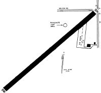
Runways
Runway Summary
| Runways: | NE/SW |
| Longest Runway: | NE/SW is 2875 ft (876 m) long |
| Runways with an Instrument Approach: |
85N Airport Runway Details
| Runway NE/SW | 2875 ft x 75 ft (876 m x 23 m) | |
| Surface: | Turf - Failed condition - No special surface treatment | |
Runway NE |
Runway SW |
|
Glide Path Angle: |
0.0 degrees | 0.0 degrees |
Traffic Pattern: |
Left | Left |
Object at End: |
TREES | TREES |
Object Height: |
75 | 92 |
Distance from End: |
20 | 0 |
Object Centerline Offset: |
115 ft. right of centerline | 96 ft. left of centerline |
REIL: |
No | No |
Touchdown Lights: |
No | No |
Centerline Lights: |
No | No |
Services
Airframe Repair: |
None |
Powerplant Repair: |
None |
Bottled Oxygen: |
None |
Bulk Oxygen: |
None |
Fuel Available: |
100LL, Jet A |
Landing Fees: |
No |
Parking: |
Hangars and tiedowns available |
Maps & Diagrams
85N Sectional
Flight Planning
at skyvector.com
at skyvector.com