Location
Latitude: |
42-58-52.6130N (42.981281) |
Longitude: |
077-56-06.8930W (-77.935248) |
Elevation: |
780.3 feet MSL (238 m MSL) |
Magnetic Variation: |
11 W (as of April 2024 from WMM2020 model) |
Time Zone: |
UTC -5.0 (Standard Time) UTC -4.0 (Daylight Savings Time) |
From City: |
02 N.M. E of Le Roy, New York |
Found On: |
Detroit Chart |
FAA Region: |
AEA |
Contacts
Manager: |
Privately owned: |
| RAY DETOR 283 WESTMINSTER ROAD ROCHESTER, NY 14607-3229 585-259-9308 |
LEROY AVIATION SERVICES INC 8267 EAST MAIN ROAD LE ROY, NY 14482 585-768-4560 |
Operations
Airport Status: |
Operational |
Facility Use: |
Public |
Type: |
Airport |
Activation Date: |
01/1964 |
Control tower: |
No |
Attendance (Months/Days/Hours): |
Months/Days/Hours ALL/MON-FRI/1000-1600 |
Boundary ARTCC: |
ZOB (Cleveland) |
Responsible ARTCC: |
ZOB (Cleveland) |
Lighting Schedule: |
SEE RMK |
Segmented Circle Indicator: |
No |
Traffic Pattern Altitude (MSL): |
1780 feet (543 m) |
NOTAMs Facility: |
BUF |
NOTAM-D Service: |
Yes |
International Airport of Entry: |
No |
Customs Landing Rights: |
No |
Military Landing Rights: |
No |
Civil/Military Joint Use: |
No |
Based Aircraft
| Single Engine: | 28 |
| Multi Engine: | 2 |
Annual Operations (as of 09/16/2021)
| Total Operations: | 14660 | |
| Air Taxi: | 120 | 0.8% |
| GA Local: | 11040 | 75.3% |
| GA Itinerant: | 3000 | 20.5% |
| Military Aircraft: | 500 | 3.4% |
Communications
| CTAF: | 122.800 |
| Unicom: | 122.800 |
| Approach: | ROCHESTER 123.7 123.7 |
| Departure: | ROCHESTER 123.7 123.7 |
Fixed Based Operators (FBOs) & Fuel
(Click on a business for detail)
Please help us keep this information up to date. This is a FREE SERVICE just like everything else on Airport Guide! If you see that a business needs to be added, modified, or deleted please fill out our Update Form.
To add, modify, or delete a business click here.
Please help us keep this information up to date. This is a FREE SERVICE just like everything else on Airport Guide! If you see that a business needs to be added, modified, or deleted please fill out our Update Form.
Area Code: 716 |
| Business Name | Frequency | Phone | Fuel Grade |
|---|---|---|---|
| LeRoy Aviation Services, Inc.
Update FBO info |
768-4560 | 80, 100LL | |

|
 Independent |
80/87 - 2.65 USD per gallon on 9/24/01 |
24 Hour Self Serve Credit Card Pumps AOPA discount |
|
|
Independent |
100LL - 2.55 USD per gallon on 9/24/01 |
24 Hour Self Serve Credit Card Pumps AOPA discount |
Flight Service Stations
| Primary | Alternate | |
| FSS on Field: | N | |
| FSS Name (ID): | Buffalo(BUF) | |
| Frequency: | ||
| Toll Free Phone: | 1-800-WX-BRIEF |
Instrument Procedures / Charts
FAA Terminal Procedures valid from 0901Z 03/21/24 to 0901Z 04/18/24.
There are various types of charts available for an airport. They are listed in the Page Type column. Here is a legend for those types:
APD - Airport Diagram
DP - Departure Procedure Charts
HOT - Hot Spots
IAP - Instrument Approach Procedure Charts
MIN - Minimums
STAR - Standard Terminal Arrival Charts
| Page Type | Page Name | Volume | Action Since Last Cycle |
|---|---|---|---|
| IAP | RNAV (GPS) RWY 10 | NE-2 | |
| IAP | RNAV (GPS) RWY 28 | NE-2 | |
| IAP | VOR-A | NE-2 | |
| MIN | TAKEOFF MINIMUMS | NE-2 |
Terminal Procedures are only available for airports in several countries with more being added all the time. If you are looking for a specific country's charts, please send an email to support(at)airportguide.com stating the country name. This will be used to prioritize the implementation.
Navigation Aids (Navaids) near 5G0
| Dist (NM) | ID | Morse Code | Name | Type | Freq | True Hdg | Mag Hdg |
|---|---|---|---|---|---|---|---|
| 7.5 | AVN | . _ . . . _ _ . | Avon | NDB | 344 | 76 | 87 |
| 12.5 | GEE | _ _ . . . | Geneseo | VOR-DME | 108.20 | 134 | 145 |
| 14.1 | ROC | . _ . _ _ _ _ . _ . | Rochester | VOR-DME | 110.00 | 54 | 65 |
| 31.4 | BUF | _ . . . . . _ . . _ . | Buffalo | DME | 116.4 | 264 | 275 |
| 31.4 | BU | _ . . . . . _ | Klump | NDB | 231 | 272 | 283 |
| 35.2 | BUF | _ . . . . . _ . . _ . | Buffalo | VOT | 109.00 | 266 | 277 |
| 39.2 | GB | _ _ . _ . . . | Plazz | NDB | 204 | 260 | 271 |
| 40.3 | IA | . . . _ | Kathi | NDB | 329 | 281 | 292 |
| 43.7 | PYA | . _ _ . _ . _ _ . _ | Penn Yan | NDB | 260 | 117 | 128 |
| 45.4 | LYS | . _ . . _ . _ _ . . . | Olean | NDB | 360 | 202 | 213 |
| 45.6 | IAG | . . . _ _ _ . | Niagara Falls | TACAN | 111.00 | 280 | 291 |
| 53.6 | ELZ | . . _ . . _ _ . . | Wellsville | DME | 115.85 | 183 | 194 |
| 58.7 | SN | St. Catharines | NDB | 408 | 280 | 291 | |
| 65.7 | ZZR | Severn | NDB | 317 | 11 | 22 | |
| 65.9 | DKK | _ . . _ . _ _ . _ | Dunkirk | DME | 116.2 | 243 | 254 |
| 66.7 | ULW | . . _ . _ . . . _ _ | Elmira | VOR-DME | 109.65 | 142 | 153 |
| 68.3 | ALP | . _ . _ . . . _ _ . | Alpine | NDB | 245 | 130 | 141 |
| 69.8 | IOO | Oshawa | DME | 111.35 | 323 | 334 | |
| 70.3 | OO | Oshawa | NDB | 391 | 323 | 334 | |
| 70.6 | UTR | Trenton | TACAN | 109.70 | 14 | 25 |
Nearby Airports with Fuel
Notices to Airmen (NOTAMS)
Remarks
| A110-2 | DEER ON AND INVOF ARPT. |
| A110-5 | RWY 28 +12 FT FENCE, 280 FT FM RWY. |
| A110-6 | FOR CD CTC CLEVELAND ARTCC AT 440-774-0490. |
| A17 | EXCEPT STATE AND FEDERAL LEGAL HOLIDAYS |
| A52-10 | ALSO +13 FT FENCE, 275' FROM RWY, 94' LT |
| A52-28 | RWY 28 +12 FT FENCE, 275 FT FROM RWY. RWY 28 +27' TREES, 201' FROM RWY, 192' RT. |
| A58-10 | RWY 10 +5' FENCE, 0-200' FROM RWY,96' LT RWY 10 +40' TREES, 180' FROM RWY, 248' RT |
| A58-28 | RWY 28 +5' FENCE, 180' FROM RWY, 98' RT. |
| A81-APT | SS-SR, ACTVT REIL RWY 10 & 28; PAPI RWY 10 & 28; MIRL RWY 10/28 - CTAF. |
| E111 | IN ACCORD WITH VFR. |
Runways
Runway Summary
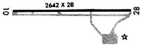
| Runways: | 10/28 |
| Longest Runway: | 10/28 is 3854 ft (1175 m) long |
| Runways with an Instrument Approach: |
5G0 Airport Runway Details
| Runway 10/28 | 3854 ft x 60 ft (1175 m x 18 m) | |
| Runway Length Source: | 3RD PARTY SURVEY as of 09/28/2010 | |
| Surface: | Asphalt - Good condition - No special surface treatment | |
| Runway Edge Lights: | Medium Intensity | |
Runway Weight Bearing Capacity (in thousands of pounds) |
||
| Single Wheel Landing Gear: | 12.5 | |
Runway 10 |
Runway 28 |
|
Elevation: |
780.0 | 778.3 |
Latitude: |
42-58-53.5617N | 42-58-51.6633N |
Longitude: |
077-56-32.7842W | 077-55-41.0013W |
|
Runway True Alignment: |
093 | 273 |
Glide Path Angle: |
3.0 degrees | 3.5 degrees |
Traffic Pattern: |
Left | Left |
Runway Markings Type: |
Nonprecision Instrument | Nonprecision Instrument |
Runway Markings Condition: |
Good | Good |
Object at End: |
TREE | TREE |
Object Height: |
51 | 76 |
Distance from End: |
235 | 392 |
Object Centerline Offset: |
164 ft. left of centerline | 255 ft. left of centerline |
Visual Glide Slope Indicators: |
2-Light PAPI On Left Side Of Runway | 2-Light PAPI On Left Side Of Runway |
REIL: |
Yes | Yes |
Touchdown Lights: |
No | No |
Centerline Lights: |
No | No |
Threshold Crossing Height: |
31 | 53 |
Services
Airframe Repair: |
Major |
Powerplant Repair: |
Minor |
Bottled Oxygen: |
None |
Bulk Oxygen: |
None |
Fuel Available: |
100LL, Jet A+ |
Landing Fees: |
No |
Parking: |
Tiedowns available |
Maps & Diagrams
5G0 Sectional
Flight Planning
at skyvector.com
at skyvector.com