Location
Latitude: |
40-43-55.5800N (40.732106) |
Longitude: |
092-25-41.7680W (-92.428269) |
Elevation: |
888.0 feet MSL (271 m MSL) |
Magnetic Variation: |
0.4 W (as of April 2024 from WMM2020 model) |
Time Zone: |
UTC -6.0 (Standard Time) UTC -5.0 (Daylight Savings Time) |
From City: |
02 N.M. SW of Bloomfield, Iowa |
Found On: |
Chicago Chart |
FAA Region: |
ACE |
Contacts
Manager: |
Publicly owned: |
| CHARLES A. SPARGUR MUNI ARPT 20956 230TH ST BLOOMFIELD, IA 52537 641-664-1255 |
CITY OF BLOOMFIELD 111 W FRANKLIN ST BLOOMFIELD, IA 52537 641-664-2260 |
Operations
Airport Status: |
Operational |
Facility Use: |
Public |
Type: |
Airport |
Activation Date: |
09/1961 |
Control tower: |
No |
Attendance (Months/Days/Hours): |
Months/Days/Hours ALL/MON-FRI/0830-1730 |
Boundary ARTCC: |
ZAU (Chicago) |
Responsible ARTCC: |
ZAU (Chicago) |
Lighting Schedule: |
SEE RMK |
Segmented Circle Indicator: |
No |
Traffic Pattern Altitude (MSL): |
1888 feet (575 m) |
NOTAMs Facility: |
FOD |
NOTAM-D Service: |
Yes |
International Airport of Entry: |
No |
Customs Landing Rights: |
No |
Military Landing Rights: |
Yes |
Civil/Military Joint Use: |
No |
Based Aircraft
| Single Engine: | 8 |
Annual Operations (as of 09/13/2023)
| Total Operations: | 2250 | |
| GA Local: | 971 | 43.2% |
| GA Itinerant: | 1279 | 56.8% |
Communications
| CTAF: | 122.800 |
| Unicom: | 122.800 |
- APCH/DEP SVC PRVDD BY CHICAGO ARTCC ON FREQS 118.15/335.575 (OTTUMWA RCAG).
Fixed Based Operators (FBOs) & Fuel
(Click on a business for detail)
Please help us keep this information up to date. This is a FREE SERVICE just like everything else on Airport Guide! If you see that a business needs to be added, modified, or deleted please fill out our Update Form.
To add, modify, or delete a business click here.
Please help us keep this information up to date. This is a FREE SERVICE just like everything else on Airport Guide! If you see that a business needs to be added, modified, or deleted please fill out our Update Form.
Area Code: 641 |
| Business Name | Frequency | Phone | Fuel Grade |
|---|---|---|---|
| Heartland Aviation
Update FBO info |
Unicom 122.8 | 664-1255, after hours call 722-3816 | 100LL |
Flight Service Stations
| Primary | Alternate | |
| FSS on Field: | N | |
| FSS Name (ID): | Fort Dodge(FOD) | |
| Frequency: | ||
| Toll Free Phone: | 1-800-WX-BRIEF |
Instrument Procedures / Charts
FAA Terminal Procedures valid from 0901Z 03/21/24 to 0901Z 04/18/24.
There are various types of charts available for an airport. They are listed in the Page Type column. Here is a legend for those types:
APD - Airport Diagram
DP - Departure Procedure Charts
HOT - Hot Spots
IAP - Instrument Approach Procedure Charts
MIN - Minimums
STAR - Standard Terminal Arrival Charts
| Page Type | Page Name | Volume | Action Since Last Cycle |
|---|---|---|---|
| IAP | RNAV (GPS) RWY 36 | NC-3 | |
| MIN | TAKEOFF MINIMUMS | NC-3 |
Terminal Procedures are only available for airports in several countries with more being added all the time. If you are looking for a specific country's charts, please send an email to support(at)airportguide.com stating the country name. This will be used to prioritize the implementation.
Navigation Aids (Navaids) near 4K6
| Dist (NM) | ID | Morse Code | Name | Type | Freq | True Hdg | Mag Hdg |
|---|---|---|---|---|---|---|---|
| 0.8 | BEX | _ . . . . _ . . _ | Bloomfield | NDB | 269 | 352 | 352 |
| 18.4 | OTM | _ _ _ _ _ _ | Ottumwa | VOR-DME | 111.60 | 14 | 14 |
| 26.0 | FFL | . . _ . . . _ . . _ . . | Fairfield | NDB | 332 | 49 | 50 |
| 29.7 | OOA | _ _ _ _ _ _ . _ | Oskaloosa | NDB | 414 | 354 | 354 |
| 36.6 | IRK | . . . _ . _ . _ | Kirksville | VORTAC | 114.60 | 191 | 191 |
| 43.4 | MPZ | _ _ . _ _ . _ _ . . | Mount Pleasant | NDB | 212 | 72 | 73 |
| 46.6 | PEA | . _ _ . . . _ | Pella | NDB | 257 | 330 | 330 |
| 47.4 | AWG | . _ . _ _ _ _ . | Washington | NDB | 219 | 45 | 46 |
| 48.1 | EOK | . _ _ _ _ . _ | Keokuk | NDB | 366 | 109 | 110 |
| 59.6 | BR | _ . . . . _ . | Burns | NDB | 390 | 94 | 95 |
| 59.9 | IOW | . . _ _ _ . _ _ | Iowa City | VOR-DME | 116.20 | 37 | 38 |
| 64.7 | MCM | _ _ _ . _ . _ _ | Macon | DME | 112.9 | 182 | 182 |
| 65.9 | BZK | _ . . . _ _ . . _ . _ | Brookfield | NDB | 383 | 208 | 208 |
| 66.0 | TRX | _ . _ . _ . . _ | Trenton | NDB | 400 | 234 | 234 |
| 68.3 | BRL | _ . . . . _ . . _ . . | Burlington | VOR-DME | 111.40 | 89 | 90 |
| 69.3 | DDD | _ . . _ . . _ . . | Port City | DME | 116.5 | 56 | 57 |
| 69.6 | DSM | _ . . . . . _ _ | Des Moines | VORTAC | 117.50 | 307 | 307 |
| 70.2 | TNU | _ _ . . . _ | Newton | VOR-DME | 112.50 | 334 | 334 |
| 70.5 | LMN | . _ . . _ _ _ . | Lamoni | VOR-DME | 116.70 | 263 | 263 |
| 73.7 | DSM | _ . . . . . _ _ | Des Moines | VOT | 109.20 | 311 | 311 |
Nearby Airports with Fuel
Notices to Airmen (NOTAMS)
Remarks
| A110*G | THIS AIRPORT HAS BEEN SURVEYED BY THE NATIONAL GEODETIC SURVEY. |
| A110-1 | FOR SVC AFTER HRS CALL 641-208-6709. |
| A110-2 | FOR CD CTC CHICAGO ARTCC AT 630-906-8921. |
| A14 | TONY |
| A81-APT | ACTVT MIRL RY 18/36 - CTAF. |
| E111 | CONDL-PRVD THE APCH TO RWY IS MAINTAINED FOR A MINIMUM 20:1 GLIDE SLOPE AND THE TRANSITIONAL SURFACE BE MAINTAINED FOR A 7:1 SLOPE. |
Runways
Runway Summary
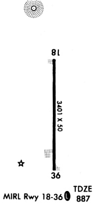
| Runways: | 18/36 |
| Longest Runway: | 18/36 is 3401 ft (1037 m) long |
| Runways with an Instrument Approach: |
4K6 Airport Runway Details
| Runway 18/36 | 3401 ft x 60 ft (1037 m x 18 m) | |
| Surface: | Concrete - Good condition - No special surface treatment | |
| Runway Pavement Class: | 6 /R/C/W/T | |
| Runway Edge Lights: | Medium Intensity | |
Runway Weight Bearing Capacity (in thousands of pounds) |
||
| Single Wheel Landing Gear: | 28.0 | |
| Dual Wheel Landing Gear: | 20.0 | |
Runway 18 |
Runway 36 |
|
Elevation: |
883.0 | 888.0 |
Latitude: |
40-44-12.3480N | 40-43-38.7440N |
Longitude: |
092-25-42.0100W | 092-25-41.5920W |
|
Runway True Alignment: |
179 | 359 |
Glide Path Angle: |
3.0 degrees | 3.0 degrees |
Traffic Pattern: |
Left | Left |
Runway Markings Type: |
Nonprecision Instrument | Nonprecision Instrument |
Runway Markings Condition: |
Good | Good |
Object at End: |
TREE | TREES |
Object Height: |
58 | 22 |
Distance from End: |
801 | 732 |
Object Centerline Offset: |
182 ft. right of centerline | 114 ft. right of centerline |
Visual Glide Slope Indicators: |
2-Light PAPI On Left Side Of Runway | 2-Light PAPI On Left Side Of Runway |
Threshold Crossing Height: |
40 | 40 |
Services
Airframe Repair: |
Minor |
Powerplant Repair: |
Minor |
Bottled Oxygen: |
None |
Bulk Oxygen: |
None |
Fuel Available: |
100LL, Jet A |
Landing Fees: |
No |
Parking: |
Hangars and tiedowns available |
Maps & Diagrams
4K6 Sectional
Flight Planning
at skyvector.com
at skyvector.com