Location
Latitude: |
40-57-42.4630N (40.961795) |
Longitude: |
080-40-38.3750W (-80.677326) |
Elevation: |
1069.6 feet MSL (326 m MSL) |
Magnetic Variation: |
8.9 W (as of April 2024 from WMM2020 model) |
Time Zone: |
UTC -5.0 (Standard Time) UTC -4.0 (Daylight Savings Time) |
From City: |
07 N.M. SW of Youngstown, Ohio |
Found On: |
Detroit Chart |
FAA Region: |
AGL |
Contacts
Manager: |
Privately owned: |
| MICHAEL E STANKO 10800 SHARROTT RD NORTH LIMA, OH 44452-9523 330-549-0337 |
MICHAEL E STANKO 8491 IVY HILL DR POLAND, OH 44514-5214 330-757-1147 |
Operations
Airport Status: |
Operational |
Facility Use: |
Public |
Type: |
Airport |
Activation Date: |
01/1947 |
Control tower: |
No |
Attendance (Months/Days/Hours): |
Months/Days/Hours ALL/ALL/0730-1800 |
Boundary ARTCC: |
ZOB (Cleveland) |
Responsible ARTCC: |
ZOB (Cleveland) |
Lighting Schedule: |
SS-SR |
Segmented Circle Indicator: |
No |
Traffic Pattern Altitude (MSL): |
2070 feet (631 m) |
NOTAMs Facility: |
CLE |
NOTAM-D Service: |
Yes |
International Airport of Entry: |
No |
Customs Landing Rights: |
No |
Military Landing Rights: |
No |
Civil/Military Joint Use: |
No |
Based Aircraft
| Single Engine: | 46 |
| Multi Engine: | 5 |
| Jet Engine: | 1 |
| GA Helicopters: | 20 |
Annual Operations (as of 09/24/2021)
| Total Operations: | 4810 | |
| Air Taxi: | 110 | 2.3% |
| GA Local: | 4000 | 83.2% |
| GA Itinerant: | 600 | 12.5% |
| Military Aircraft: | 100 | 2.1% |
Communications
| CTAF: | 123.050 |
| Unicom: | 123.050 |
| Clearance Del.: | 119.25 119.25 119.25 |
| Approach: | CLEVELAND CLEVELAND ARTCC |
| Departure: | CLEVELAND CLEVELAND ARTCC |
- APCH/DEP SVC PRVDD BY CLEVELAND APCH (CLE) 0600-0100. APCH/DEP SVC PRVDD BY CLEVELAND ARTCC (ZOB) ON FREQS 120.6/379.275 (MOUNT HOPE RCAG) 0100-0600.
Fixed Based Operators (FBOs) & Fuel
(Click on a business for detail)
Please help us keep this information up to date. This is a FREE SERVICE just like everything else on Airport Guide! If you see that a business needs to be added, modified, or deleted please fill out our Update Form.
To add, modify, or delete a business click here.
Please help us keep this information up to date. This is a FREE SERVICE just like everything else on Airport Guide! If you see that a business needs to be added, modified, or deleted please fill out our Update Form.
Area Code: 330 |
| Business Name | Frequency | Phone | Fuel Grade |
|---|---|---|---|
| Crosswind Aviation, Inc.
Update FBO info |
Unicom 123.05 | 549-3736 | |
| Gemco Aviation
Update FBO info |
Unicom 123.05 | 549-0337 | 80, 100LL, Jet A |
Flight Service Stations
| Primary | Alternate | |
| FSS on Field: | N | |
| FSS Name (ID): | Cleveland(CLE) | |
| Frequency: | ||
| Toll Free Phone: | 1-800-WX-BRIEF |
Instrument Procedures / Charts
FAA Terminal Procedures valid from 0901Z 03/21/24 to 0901Z 04/18/24.
There are various types of charts available for an airport. They are listed in the Page Type column. Here is a legend for those types:
APD - Airport Diagram
DP - Departure Procedure Charts
HOT - Hot Spots
IAP - Instrument Approach Procedure Charts
MIN - Minimums
STAR - Standard Terminal Arrival Charts
| Page Type | Page Name | Volume | Action Since Last Cycle |
|---|---|---|---|
| IAP | RNAV (GPS) RWY 10 | EC-2 | |
| IAP | RNAV (GPS) RWY 28 | EC-2 | |
| MIN | TAKEOFF MINIMUMS | EC-2 |
Terminal Procedures are only available for airports in several countries with more being added all the time. If you are looking for a specific country's charts, please send an email to support(at)airportguide.com stating the country name. This will be used to prioritize the implementation.
Navigation Aids (Navaids) near 4G4
| Dist (NM) | ID | Morse Code | Name | Type | Freq | True Hdg | Mag Hdg |
|---|---|---|---|---|---|---|---|
| 12.4 | UCP | . . _ _ . _ . . _ _ . | Castle | NDB | 272 | 72 | 81 |
| 13.2 | HBD | . . . . _ . . . _ . . | Hubbard | NDB | 408 | 29 | 38 |
| 14.8 | YN | _ . _ _ _ . | Fetch | NDB | 338 | 14 | 23 |
| 22.2 | YNG | _ . _ _ _ . _ _ . | Youngstown | VORTAC | 109.00 | 0 | 9 |
| 22.7 | EWC | . . _ _ _ . _ . | Ellwood City | VOR-DME | 115.80 | 111 | 120 |
| 25.3 | ACO | . _ _ . _ . _ _ _ | Akron | VOR-DME | 114.40 | 290 | 299 |
| 32.8 | AK | . _ _ . _ | Akron | NDB | 362 | 281 | 290 |
| 34.8 | CAK | _ . _ . . _ _ . _ | Akron/Canton Regional | VOT | 110.60 | 265 | 274 |
| 35.9 | MMJ | _ _ _ _ . _ _ _ | Montour | DME | 112 | 142 | 151 |
| 36.7 | BSV | _ . . . . . . . . . _ | Briggs | VOR-DME | 112.40 | 249 | 258 |
| 39.9 | CXR | _ . _ . _ . . _ . _ . | Chardon | VOR-DME | 112.70 | 326 | 335 |
| 42.4 | HLG | . . . . . _ . . _ _ . | Wheeling | VOR-DME | 114.25 | 173 | 182 |
| 46.1 | CFX | _ . _ . . . _ . _ . . _ | Cadiz | NDB | 239 | 199 | 208 |
| 46.8 | FKL | . . _ . _ . _ . _ . . | Franklin | VOR | 109.60 | 52 | 61 |
| 48.0 | JFN | . _ _ _ . . _ . _ . | Jefferson | DME | 115.2 | 356 | 365 |
| 50.2 | AGC | . _ _ _ . _ . _ . | Allegheny | VOR-DME | 110.00 | 144 | 153 |
| 53.6 | LQL | . _ . . _ _ . _ . _ . . | Lakeland | NDB | 263 | 324 | 333 |
| 54.7 | MKP | _ _ _ . _ . _ _ . | Mc Keesport | NDB | 287 | 131 | 140 |
| 56.3 | CIP | _ . _ . . . . _ _ . | Clarion | DME | 112.9 | 78 | 87 |
| 57.0 | AIR | . _ . . . _ . | Bellaire | VOR-DME | 117.10 | 186 | 195 |
Nearby Airports with Fuel
Notices to Airmen (NOTAMS)
Remarks
| A110-1 | TWR 1085'AGL /2118'MSL/ LCTD 7-1/2 NM NNE. |
| A110-3 | FOR CD CTC CLEVELAND APCH AT 216-352-2323, WHEN APCH CLSD CTC CLEVELAND ARTCC AT 440-774-0223/0490. |
| A17 | UNATNDD EASTER, THANKSGIVING, & CHRISTMAS. |
| A30A-10 | CALM WIND RWY. |
| A33-10/28 | LRG TRANSVERSE CTL CRACKS SPACED DOWN RWY. |
| A57-10 | APCH RATIO 0:1 DUE TO NMRS TREES, 200 FT DIST, 130 FT L/R. |
| A57-28 | APCH RATIO 0:1 TO DTHR DUE TO 18 FT ROAD, 163 FT DIST, 0 FT B; 5 FT FENCE, 140 FT DIST, 0 FT B; +25 FT HNGR, 45-100 FT DIST, 207 FT L. |
| A58-10 | NMRS LRG TREES, 200 FT DIST, 130 FT L/R. |
| A58-28 | 18 FT ROAD, 163-200 FT DIST, 0 FT B; 5 FT FENCE, 140 FT DIST, 0 FT B; +25 FT HNGR, 45-100 FT DIST, 207 FT L. |
| A75 | PRIOR CDN RQRD. |
| E111 | ESTABD BFR 1959. |
Runways
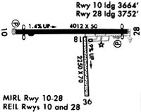
Runway Summary
| Runways: | 10/28 |
| Longest Runway: | 10/28 is 4012 ft (1223 m) long |
| Runways with an Instrument Approach: |
4G4 Airport Runway Details
| Runway 10/28 | 4012 ft x 50 ft (1223 m x 15 m) | |
| Surface: | Asphalt - Fair condition - No special surface treatment | |
| Runway Edge Lights: | Medium Intensity | |
Runway 10 |
Runway 28 |
|
Elevation: |
1012.0 | 1069.6 |
Latitude: |
40-57-42.2090N | 40-57-41.9010N |
Longitude: |
080-41-04.5920W | 080-40-12.3000W |
|
Runway True Alignment: |
090 | 270 |
Glide Path Angle: |
0.0 degrees | 3.8 degrees |
Traffic Pattern: |
Left | Left |
Runway Markings Type: |
Nonprecision Instrument | Nonprecision Instrument |
Runway Markings Condition: |
Good | Good |
Object at End: |
TREES | TREES |
Object Height: |
85 | 90 |
Distance from End: |
215 | 201 |
Object Centerline Offset: |
225 ft. left and right of centerline | 225 ft. left of centerline |
Visual Glide Slope Indicators: |
2-Light PAPI On Left Side Of Runway | 2-Light PAPI On Left Side Of Runway |
REIL: |
Yes | Yes |
Threshold Elevation: |
1011.5 | 1063.3 |
Displaced Threshold: |
348 | 259 |
Threshold Latitude: |
40-57-42.1830N | 40-57-41.9210N |
Threshold Longitude: |
080-41-00.0710W | 080-40-15.7250W |
Services
Airframe Repair: |
None |
Powerplant Repair: |
None |
Bottled Oxygen: |
None |
Bulk Oxygen: |
None |
Fuel Available: |
100LL, Jet A |
Landing Fees: |
Yes |
Parking: |
Hangars and tiedowns available |
Maps & Diagrams
4G4 Sectional
Flight Planning
at skyvector.com
at skyvector.com