Location
Latitude: |
43-20-00.2180N (43.333394) |
Longitude: |
095-09-32.7330W (-95.159093) |
Elevation: |
1439.0 feet MSL (439 m MSL) |
Magnetic Variation: |
1.5 E (as of April 2024 from WMM2020 model) |
Time Zone: |
UTC -6.0 (Standard Time) UTC -5.0 (Daylight Savings Time) |
From City: |
01 N.M. NW of Milford, Iowa |
Found On: |
Omaha Chart |
FAA Region: |
ACE |
Contacts
Manager: |
Publicly owned: |
| CHRISTOPHER STEIN P.O. BOX 463 MILFORD, IA 51351 712-260-4335 |
CITY OF MILFORD PO BOX 536 MILFORD, IA 51351 712-260-4335 |
Operations
Airport Status: |
Operational |
Facility Use: |
Public |
Type: |
Airport |
Activation Date: |
07/1945 |
Control tower: |
No |
Attendance (Months/Days/Hours): |
Months/Days/Hours Unattended |
Boundary ARTCC: |
ZMP (Minneapolis) |
Responsible ARTCC: |
ZMP (Minneapolis) |
Lighting Schedule: |
SS-SR |
Segmented Circle Indicator: |
Yes |
Traffic Pattern Altitude (MSL): |
2439 feet (743 m) |
NOTAMs Facility: |
FOD |
NOTAM-D Service: |
Yes |
Military Landing Rights: |
Yes |
Civil/Military Joint Use: |
No |
Based Aircraft
| Single Engine: | 13 |
| Multi Engine: | 1 |
| Ultralights: | 1 |
Annual Operations (as of 08/22/2018)
| Total Operations: | 3850 | |
| GA Local: | 761 | 19.8% |
| GA Itinerant: | 3089 | 80.2% |
Communications
| CTAF: | 122.900 |
- APCH/DEP SVC PRVDD BY MINNEAPOLIS ARTCC ON FREQS 127.75/257.7 (FAIRMONT RCAG).
Fixed Based Operators (FBOs) & Fuel
(Click on a business for detail)
Please help us keep this information up to date. This is a FREE SERVICE just like everything else on Airport Guide! If you see that a business needs to be added, modified, or deleted please fill out our Update Form.
To add, modify, or delete a business click here.
Please help us keep this information up to date. This is a FREE SERVICE just like everything else on Airport Guide! If you see that a business needs to be added, modified, or deleted please fill out our Update Form.
Area Code: 712 |
| Business Name | Frequency | Phone | Fuel Grade |
|---|
Flight Service Stations
| Primary | Alternate | |
| FSS on Field: | N | |
| FSS Name (ID): | Fort Dodge(FOD) | |
| Frequency: | ||
| Toll Free Phone: | 1-800-WX-BRIEF |
Instrument Procedures / Charts
FAA Terminal Procedures valid from 0901Z 03/21/24 to 0901Z 04/18/24.
There are various types of charts available for an airport. They are listed in the Page Type column. Here is a legend for those types:
APD - Airport Diagram
DP - Departure Procedure Charts
HOT - Hot Spots
IAP - Instrument Approach Procedure Charts
MIN - Minimums
STAR - Standard Terminal Arrival Charts
| Page Type | Page Name | Volume | Action Since Last Cycle |
|---|---|---|---|
| IAP | RNAV (GPS)-B | NC-3 | |
| IAP | VOR-A | NC-3 | |
| MIN | TAKEOFF MINIMUMS | NC-3 |
Terminal Procedures are only available for airports in several countries with more being added all the time. If you are looking for a specific country's charts, please send an email to support(at)airportguide.com stating the country name. This will be used to prioritize the implementation.
Navigation Aids (Navaids) near 4D8
| Dist (NM) | ID | Morse Code | Name | Type | Freq | True Hdg | Mag Hdg |
|---|---|---|---|---|---|---|---|
| 9.5 | SP | . . . . _ _ . | Snore | NDB | 394 | 231 | 229 |
| 10.4 | SPW | . . . . _ _ . . _ _ | Spencer | VOR-DME | 115.15 | 190 | 189 |
| 12.4 | LTU | . _ . . _ . . _ | Little Sioux | NDB | 326 | 174 | 173 |
| 18.4 | PUF | . _ _ . . . _ . . _ . | Puff | NDB | 345 | 86 | 85 |
| 18.6 | EST | . . . . _ | Estherville | VOR | 110.40 | 75 | 74 |
| 20.3 | MJQ | _ _ . _ _ _ _ _ . _ | Jackson | NDB-DME | 353 | 21 | 20 |
| 21.6 | OT | _ _ _ _ | Wondd | NDB | 277 | 322 | 320 |
| 24.2 | EGQ | . _ _ . _ _ . _ | Emmetsburg | NDB | 410 | 125 | 124 |
| 26.0 | ISB | . . . . . _ . . . | Sibley | NDB | 269 | 274 | 272 |
| 26.3 | OTG | _ _ _ _ _ _ . | Worthington | DME | 110.6 | 315 | 313 |
| 30.3 | SHL | . . . . . . . . _ . . | Sheldon | NDB | 338 | 256 | 254 |
| 34.6 | MWM | _ _ . _ _ _ _ | Windom | NDB | 203 | 3 | 2 |
| 37.1 | FRM | . . _ . . _ . _ _ | Fairmont | DME | 110.2 | 59 | 58 |
| 37.3 | FNX | . . _ . _ . _ . . _ | Fairmont | DME | 114.25 | 60 | 59 |
| 39.4 | FQ | . . _ . _ _ . _ | Montz | NDB | 420 | 68 | 67 |
| 41.6 | AXA | . _ _ . . _ . _ | Algona | NDB | 403 | 110 | 109 |
| 41.7 | POH | . _ _ . _ _ _ . . . . | Pocahontas | NDB | 428 | 147 | 146 |
| 44.1 | SLB | . . . . _ . . _ . . . | Storm Lake | NDB | 434 | 184 | 182 |
| 44.5 | ORC | _ _ _ . _ . _ . _ . | Orange City | NDB | 521 | 242 | 240 |
| 46.6 | SOY | . . . _ _ _ _ . _ _ | Sioux Center | NDB | 368 | 255 | 253 |
Nearby Airports with Fuel
Notices to Airmen (NOTAMS)
Remarks
| A110*G | THIS AIRPORT HAS BEEN SURVEYED BY THE NATIONAL GEODETIC SURVEY. |
| A110-1 | RY 27 IS CALM WIND RY. |
| A110-2 | FOR CD CTC MINNEAPOLIS ARTCC AT 651-463-5588. |
| A42-18 | 18/36 MARKED WITH YELLOW CONES. |
| A57-09 | APCH SLOPE 31:1 TO DSPLCD THLD. |
| A57-27 | RY 27 APCH SLOPE 24:1 TO DSPLCD THLD. |
| A57-36 | RY 36 APCH SLOPE 20:1 TO DSPLCD THLD. |
| A70-FUEL-10 | 0LL SELF SERVE 100LL. |
| E111 | PRVDD RWY APCHS IS MAINT FOR MIN 20:1 GLIDE SLOPE & TRSNL SFC MAINT FOR 7:1 SLOPE. |
Runways
Runway Summary
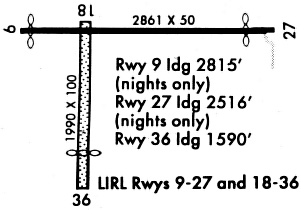
| Runways: | 09/27 18/36 |
| Longest Runway: | 09/27 is 2873 ft (876 m) long |
| Runways with an Instrument Approach: |
4D8 Airport Runway Details
| Runway 09/27 | 2873 ft x 50 ft (876 m x 15 m) | |
| Surface: | Asphalt - Good condition - No special surface treatment | |
| Runway Edge Lights: | Low Intensity | |
Runway 09 |
Runway 27 |
|
Elevation: |
1437.0 | 1436.0 |
Latitude: |
43-20-05.1100N | 43-20-05.1800N |
Longitude: |
095-09-48.0600W | 095-09-09.1900W |
|
Runway True Alignment: |
090 | 270 |
Glide Path Angle: |
0.0 degrees | 0.0 degrees |
Traffic Pattern: |
Left | Right |
Runway Markings Type: |
Basic | Basic |
Runway Markings Condition: |
Fair | Fair |
Object at End: |
ROAD | TREE |
Object Height: |
15 | 35 |
Distance from End: |
420 | 507 |
Object Centerline Offset: |
0 ft. left and right of centerline | 52 ft. left of centerline |
Threshold Elevation: |
1436.1 | 1436.1 |
Displaced Threshold: |
60 | 360 |
Threshold Latitude: |
43-20-05.1100N | 43-20-05.1700N |
Threshold Longitude: |
095-09-47.2500W | 095-09-14.0600W |
| Runway 18/36 | 2200 ft x 100 ft (671 m x 30 m) | |
| Runway Length Source: | FAA OE/AAA as of 04/04/2022 | |
| Surface: | Asphalt - Good condition - No special surface treatment | |
| Runway Edge Lights: | Low Intensity | |
Runway 18 |
Runway 36 |
|
Elevation: |
1436.0 | 1429.0 |
Latitude: |
43-20-04.6400N | 43-19-42.9200N |
Longitude: |
095-09-38.1000W | 095-09-38.1000W |
|
Runway True Alignment: |
180 | 000 |
Glide Path Angle: |
0.0 degrees | 0.0 degrees |
Traffic Pattern: |
Right | Left |
Object at End: |
FENCE | TREE |
Object Height: |
5 | 50 |
Distance from End: |
155 | 633 |
Object Centerline Offset: |
0 ft. left and right of centerline | 52 ft. left of centerline |
Threshold Elevation: |
1429.0 | |
Displaced Threshold: |
700 | |
Threshold Latitude: |
43-19-49.8340N | |
Threshold Longitude: |
095-09-38.1000W |
Services
Airframe Repair: |
Major |
Powerplant Repair: |
Major |
Bottled Oxygen: |
None |
Bulk Oxygen: |
None |
Fuel Available: |
100LL |
Landing Fees: |
No |
Parking: |
Tiedowns available |
Maps & Diagrams
4D8 Sectional
Flight Planning
at skyvector.com
at skyvector.com