Location
Latitude: |
34-01-06.7050N (34.018529) |
Longitude: |
085-08-41.1320W (-85.144759) |
Elevation: |
973.7 feet MSL (297 m MSL) |
Magnetic Variation: |
5 W (as of April 2024 from WMM2020 model) |
Time Zone: |
UTC -5.0 (Standard Time) UTC -4.0 (Daylight Savings Time) |
From City: |
05 N.M. E of Cedartown, Georgia |
Found On: |
Atlanta Chart |
FAA Region: |
ASO |
Contacts
Manager: |
Publicly owned: |
| CHUCK BEAVERS 500 AIRPORT ROAD, 144 WEST AVE CEDARTOWN, GA 30125 770-684-7136 |
POLK COUNTY 216 MAIN ST CEDARTOWN, GA 30125 770-749-2100 |
Operations
Airport Status: |
Operational |
Facility Use: |
Public |
Type: |
Airport |
Activation Date: |
02/1963 |
Control tower: |
No |
Attendance (Months/Days/Hours): |
Months/Days/Hours ALL/ALL/0900-1700 |
Boundary ARTCC: |
ZTL (Atlanta) |
Responsible ARTCC: |
ZTL (Atlanta) |
Lighting Schedule: |
SEE RMK |
Segmented Circle Indicator: |
Yes |
Traffic Pattern Altitude (MSL): |
1974 feet (602 m) |
NOTAMs Facility: |
MCN |
NOTAM-D Service: |
Yes |
International Airport of Entry: |
No |
Customs Landing Rights: |
No |
Military Landing Rights: |
Yes |
Civil/Military Joint Use: |
No |
Based Aircraft
| Single Engine: | 45 |
| Multi Engine: | 4 |
| GA Helicopters: | 8 |
| Ultralights: | 1 |
Annual Operations (as of 12/31/2022)
| Total Operations: | 15050 | |
| GA Local: | 11000 | 73.1% |
| GA Itinerant: | 4000 | 26.6% |
| Military Aircraft: | 50 | 0.3% |
Communications
| CTAF: | 122.800 |
| Unicom: | 122.800 |
- APCH/DEP SVC PRVDD BY ATLANTA ARTCC ON FREQS 124.5/270.325 (GADSDEN RCAG).
Fixed Based Operators (FBOs) & Fuel
(Click on a business for detail)
Please help us keep this information up to date. This is a FREE SERVICE just like everything else on Airport Guide! If you see that a business needs to be added, modified, or deleted please fill out our Update Form.
To add, modify, or delete a business click here.
Please help us keep this information up to date. This is a FREE SERVICE just like everything else on Airport Guide! If you see that a business needs to be added, modified, or deleted please fill out our Update Form.
Area Code: 770 |
| Business Name | Frequency | Phone | Fuel Grade |
|---|---|---|---|
| Cedar Valley Aviation
Update FBO info |
684-7136 | 100LL |
Flight Service Stations
| Primary | Alternate | |
| FSS on Field: | N | |
| FSS Name (ID): | Macon(MCN) | |
| Frequency: | ||
| Toll Free Phone: | 1-800-WX-BRIEF |
Instrument Procedures / Charts
FAA Terminal Procedures valid from 0901Z 03/21/24 to 0901Z 04/18/24.
There are various types of charts available for an airport. They are listed in the Page Type column. Here is a legend for those types:
APD - Airport Diagram
DP - Departure Procedure Charts
HOT - Hot Spots
IAP - Instrument Approach Procedure Charts
MIN - Minimums
STAR - Standard Terminal Arrival Charts
| Page Type | Page Name | Volume | Action Since Last Cycle |
|---|---|---|---|
| IAP | RNAV (GPS) RWY 10 | SE-4 | Changed |
| IAP | RNAV (GPS) RWY 28 | SE-4 | Changed |
| MIN | TAKEOFF MINIMUMS | SE-4 |
Terminal Procedures are only available for airports in several countries with more being added all the time. If you are looking for a specific country's charts, please send an email to support(at)airportguide.com stating the country name. This will be used to prioritize the implementation.
Navigation Aids (Navaids) near 4A4
| Dist (NM) | ID | Morse Code | Name | Type | Freq | True Hdg | Mag Hdg |
|---|---|---|---|---|---|---|---|
| 8.7 | RMG | . _ . _ _ _ _ . | Rome | VORTAC | 115.40 | 8 | 13 |
| 18.5 | EVZ | . . . . _ _ _ . . | Cartersville | NDB | 308 | 54 | 59 |
| 25.4 | OUK | _ _ _ . . _ _ . _ | Calhoun | NDB | 323 | 25 | 30 |
| 27.2 | GPQ | _ _ . . _ _ . _ _ . _ | Carrollton | NDB | 278 | 178 | 183 |
| 29.5 | FT | . . _ . _ | Flanc | NDB | 344 | 121 | 126 |
| 32.3 | DOB | _ . . _ _ _ _ . . . | Dobbins | TACAN | 113.00 | 100 | 105 |
| 35.5 | DJD | _ . . . _ _ _ _ . . | Chero | NDB | 415 | 66 | 71 |
| 40.0 | FTP | . . _ . _ . _ _ . | Fort Payne | NDB | 426 | 319 | 324 |
| 41.9 | ATL | . _ _ . _ . . | Atlanta Muni | VOT | 111.00 | 120 | 125 |
| 42.4 | ATL | . _ _ . _ . . | Atlanta | DME | 116.9 | 123 | 128 |
| 43.0 | PDK | . _ _ . _ . . _ . _ | Peachtree | VOR-DME | 116.60 | 101 | 106 |
| 43.2 | GSU | _ _ . . . . . . _ | Atlanta | DME | 116.9 | 122 | 127 |
| 46.8 | GAD | _ _ . . _ _ . . | Gadsden | VOR-DME | 112.30 | 267 | 272 |
| 47.2 | BR | _ . . . . _ . | Redan | NDB | 266 | 118 | 123 |
| 47.4 | UWI | . . _ . _ _ . . | Whitfield | NDB | 400 | 12 | 17 |
| 48.8 | AN | . _ _ . | Bogga | NDB | 211 | 233 | 238 |
| 50.5 | EQQ | . _ _ . _ _ _ . _ | Coweta County | NDB | 234 | 154 | 159 |
| 52.1 | TDG | _ _ . . _ _ . | Talladega | DME | 108.8 | 239 | 244 |
| 54.2 | FFC | . . _ . . . _ . _ . _ . | Pecat | NDB | 316 | 142 | 147 |
| 55.4 | ARF | . _ . _ . . . _ . | Saratoga | NDB | 296 | 285 | 290 |
Nearby Airports with Fuel
Notices to Airmen (NOTAMS)
Remarks
| A110-1 | DEER & BIRDS ON & INVOF OF ARPT. |
| A110-2 | EXTENSIVE PARACHUTE ACTIVITY ON WEEKENDS - AVOID OVERFLIGHTS OF ARPT. |
| A110-3 | FOR CD CTC ATLANTA ARTCC AT 770-210-7692. |
| A110-4 | MNT CTAF FREQ AND FRQLY BCST LCTN AND INTNS FOR RWY USE DUE TO NO LINE OF SIGHT BTN RWY ENDS. |
| A110-5 | RWY 10 IS THE PREFERRED DEP RWY DURG CALM WINDS. |
| A110-6 | NO LINE OF SIGHT BTN RWY ENDS. |
| A16 | FBO 770-684-7136. |
| A81-APT | ACTVT PAPI RWY 10 & 28; MIRL RWY 10/28 - CTAF. |
Runways
Runway Summary
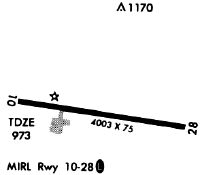
| Runways: | 10/28 |
| Longest Runway: | 10/28 is 5060 ft (1542 m) long |
| Runways with an Instrument Approach: |
4A4 Airport Runway Details
| Runway 10/28 | 5060 ft x 75 ft (1542 m x 23 m) | |
| Runway Length Source: | 3RD PARTY SURVEY as of 01/22/2022 | |
| Surface: | Asphalt - Fair condition - No special surface treatment | |
| Runway Edge Lights: | Medium Intensity | |
Runway Weight Bearing Capacity (in thousands of pounds) |
||
| Single Wheel Landing Gear: | 20.0 | |
Runway 10 |
Runway 28 |
|
Elevation: |
971.2 | 938.1 |
Latitude: |
34-01-09.7633N | 34-01-03.6439N |
Longitude: |
085-09-10.9636W | 085-08-11.3017W |
|
Runway True Alignment: |
097 | 277 |
Glide Path Angle: |
3.0 degrees | 3.0 degrees |
Traffic Pattern: |
Left | Left |
Runway Markings Type: |
Nonprecision Instrument | Nonprecision Instrument |
Runway Markings Condition: |
Good | Good |
Object at End: |
TREES | |
Object Height: |
26 | |
Distance from End: |
356 | |
Object Centerline Offset: |
227 ft. right of centerline | |
Visual Glide Slope Indicators: |
2-Light PAPI On Left Side Of Runway | 2-Light PAPI On Left Side Of Runway |
Threshold Crossing Height: |
41 | 43 |
Services
Airframe Repair: |
Major |
Powerplant Repair: |
Major |
Bottled Oxygen: |
Low Pressure |
Bulk Oxygen: |
None |
Fuel Available: |
100LL, Jet A+ |
Landing Fees: |
No |
Parking: |
Tiedowns available |
Maps & Diagrams
4A4 Sectional
Flight Planning
at skyvector.com
at skyvector.com