Location
Latitude: |
29-15-00.1000N (29.250028) |
Longitude: |
081-27-33.6000W (-81.459333) |
Elevation: |
63.0 feet MSL (19 m MSL) |
Magnetic Variation: |
6.9 W (as of April 2024 from WMM2020 model) |
Time Zone: |
UTC -5.0 (Standard Time) UTC -4.0 (Daylight Savings Time) |
From City: |
01 N.M. N of Pierson, Florida |
Found On: |
Jacksonville Chart |
FAA Region: |
ASO |
Contacts
Manager: |
Publicly owned: |
| OLIN CANNON 106 N CENTER ST PIERSON, FL 32180 386-327-1839 |
TOWN OF PIERSON 106 N CENTER ST PIERSON, FL 32180 904-749-2661 |
Operations
Airport Status: |
Operational |
Facility Use: |
Public |
Type: |
Airport |
Activation Date: |
12/1946 |
Control tower: |
No |
Attendance (Months/Days/Hours): |
Months/Days/Hours Unattended |
Boundary ARTCC: |
ZJX (Jacksonville) |
Responsible ARTCC: |
ZJX (Jacksonville) |
Segmented Circle Indicator: |
No |
Traffic Pattern Altitude (MSL): |
1063 feet (324 m) |
NOTAMs Facility: |
PIE |
NOTAM-D Service: |
Yes |
Based Aircraft
| Single Engine: | 12 |
| Gliders: | 9 |
Annual Operations (as of 08/13/2018)
| Total Operations: | 14040 | |
| GA Local: | 4040 | 28.8% |
| GA Itinerant: | 10000 | 71.2% |
Communications
| CTAF: | 122.900 |
Fixed Based Operators (FBOs) & Fuel
(Click on a business for detail)
Please help us keep this information up to date. This is a FREE SERVICE just like everything else on Airport Guide! If you see that a business needs to be added, modified, or deleted please fill out our Update Form.
To add, modify, or delete a business click here.
Please help us keep this information up to date. This is a FREE SERVICE just like everything else on Airport Guide! If you see that a business needs to be added, modified, or deleted please fill out our Update Form.
Area Code: 904 |
| Business Name | Frequency | Phone | Fuel Grade |
|---|
Flight Service Stations
| Primary | Alternate | |
| FSS on Field: | N | |
| FSS Name (ID): | Saint Petersburg(PIE) | |
| Frequency: | ||
| Toll Free Phone: | 1-800-WX-BRIEF |
Instrument Procedures / Charts
Terminal Procedures are only available for airports in several countries with more being added all the time. If you are looking for a specific country's charts, please send an email to support(at)airportguide.com stating the country name. This will be used to prioritize the implementation.
Navigation Aids (Navaids) near 2J8
| Dist (NM) | ID | Morse Code | Name | Type | Freq | True Hdg | Mag Hdg |
|---|---|---|---|---|---|---|---|
| 14.6 | DED | _ . . . _ . . | Deland/Dcmsnd | NDB | 201 | 138 | 145 |
| 18.4 | OMN | _ _ _ _ _ _ . | Ormond Beach | VORTAC | 112.60 | 79 | 86 |
| 21.5 | DAB | _ . . . _ _ . . . | Daytona Beach | VOT | 111.00 | 100 | 107 |
| 29.6 | EVB | . . . . _ _ . . . | New Smyrna Beach | NDB | 417 | 113 | 120 |
| 30.1 | SFB | . . . . . _ . _ . . . | Sanford | NDB | 408 | 157 | 164 |
| 30.4 | IAK | . . . _ _ . _ | Palatka | NDB | 243 | 322 | 329 |
| 31.7 | LEE | . _ . . . . | Leesburg | NDB | 335 | 215 | 222 |
| 40.4 | OCF | _ _ _ _ . _ . . . _ . | Ocala | VORTAC | 113.70 | 264 | 271 |
| 42.9 | SGJ | . . . _ _ . . _ _ _ | St Augustine | VOR-DME | 109.40 | 8 | 15 |
| 42.9 | ORL | _ _ _ . _ . . _ . . | Orlando | VORTAC | 112.20 | 171 | 178 |
| 44.2 | RYD | . _ . _ . _ _ _ . . | Reynolds | NDB | 338 | 346 | 353 |
| 44.6 | OR | _ _ _ . _ . | Herny | NDB | 221 | 178 | 185 |
| 45.0 | GN | _ _ . _ . | Wynds | NDB | 269 | 304 | 311 |
| 50.1 | GNV | _ _ . _ . . . . _ | Gators | VORTAC | 116.20 | 302 | 309 |
| 56.4 | TVV | _ . . . _ . . . _ | Space Center Executive | NDB | 237 | 141 | 148 |
| 60.2 | NIP | _ . . . . _ _ . | Jacksonville | TACAN | 108.20 | 349 | 356 |
| 62.0 | VQQ | . . . _ _ _ . _ _ _ . _ | Cecil | VOR | 117.90 | 338 | 345 |
| 65.4 | CRG | _ . _ . . _ . _ _ . | Craig | VORTAC | 114.50 | 357 | 364 |
| 68.3 | NRB | _ . . _ . _ . . . | Mayport | TACAN | 111.40 | 1 | 8 |
| 70.8 | EYA | . _ . _ _ . _ | Eastport | NDB | 357 | 353 | 360 |
Nearby Airports with Fuel
Notices to Airmen (NOTAMS)
Remarks
| A110-1 | 30 FT TREES + OR - 125 FT FM CNTRLN FULL LEN RWY 05/23. |
| A110-2 | FOR CD OR TO CNL IFR CTC DAB APCH AT 386-226-3939. |
| A42-05 | BNDRY MARKERS (SINGLE YELLOW CONES) EVERY 200'. |
| A42-23 | BDRY MKRS (SNGL YELLOW CONES) EV 200 FT. |
| A52-05 | 95 FT ANT 1900 FT FM RY END. |
| E111 | EXISTED PRIOR TO 1959. |
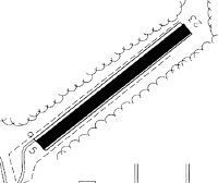
Runways
Runway Summary
| Runways: | 05/23 |
| Longest Runway: | 05/23 is 2600 ft (792 m) long |
| Runways with an Instrument Approach: |
2J8 Airport Runway Details
| Runway 05/23 | 2600 ft x 200 ft (792 m x 61 m) | |
| Surface: | Turf - Fair condition - No special surface treatment | |
Runway 05 |
Runway 23 |
|
Elevation: |
59.0 | 55.0 |
Latitude: |
29-14-51.2739N | 29-15-08.9869N |
Longitude: |
081-27-44.2757W | 081-27-22.9704W |
|
Runway True Alignment: |
047 | 227 |
Glide Path Angle: |
0.0 degrees | 0.0 degrees |
Traffic Pattern: |
Left | Right |
Runway Markings Type: |
Nonstandard (other than numbers only) | Nonstandard (other than numbers only) |
Runway Markings Condition: |
Good | Good |
Object at End: |
POLE | TREES |
Object Height: |
62 | 42 |
Distance from End: |
1240 | 830 |
Object Centerline Offset: |
105 ft. left of centerline | 62 ft. right of centerline |
Services
Airframe Repair: |
Major |
Powerplant Repair: |
Major |
Bottled Oxygen: |
None |
Bulk Oxygen: |
None |
Fuel Available: |
100LL, Jet A |
Landing Fees: |
No |
Parking: |
Hangars and tiedowns available |
Maps & Diagrams
2J8 Sectional
Flight Planning
at skyvector.com
at skyvector.com