Location
Latitude: |
38-14-03.9630N (38.234434) |
Longitude: |
084-26-04.8610W (-84.434684) |
Elevation: |
947.7 feet MSL (289 m MSL) |
Magnetic Variation: |
6 W (as of April 2024 from WMM2020 model) |
Time Zone: |
UTC -5.0 (Standard Time) UTC -4.0 (Daylight Savings Time) |
From City: |
06 N.M. E of Georgetown, Kentucky |
Found On: |
Cincinnati Chart |
FAA Region: |
ASO |
Contacts
Manager: |
Publicly owned: |
| JAMES TOOLE 6206 PARIS PIKE GEORGETOWN, KY 40324 502-863-6320 |
GEORGETOWN SCOTT COUNT AIRPORT CORP 6206 PARIS PIKE GEORGETOWN, KY 40324 502-863-6320 |
Operations
Airport Status: |
Operational |
Facility Use: |
Public |
Type: |
Airport |
Activation Date: |
04/1993 |
Control tower: |
No |
Attendance (Months/Days/Hours): |
Months/Days/Hours ALL/SAT/0800-1800 |
Boundary ARTCC: |
ZID (Indianapolis) |
Responsible ARTCC: |
ZID (Indianapolis) |
Lighting Schedule: |
SEE RMK |
Segmented Circle Indicator: |
Yes |
Traffic Pattern Altitude (MSL): |
1948 feet (594 m) |
NOTAMs Facility: |
LOU |
NOTAM-D Service: |
Yes |
Based Aircraft
| Single Engine: | 41 |
| Multi Engine: | 4 |
| Jet Engine: | 9 |
| GA Helicopters: | 10 |
Annual Operations (as of 06/20/2022)
| Total Operations: | 19400 | |
| Air Taxi: | 1100 | 5.7% |
| GA Local: | 8500 | 43.8% |
| GA Itinerant: | 9000 | 46.4% |
| Military Aircraft: | 800 | 4.1% |
Communications
| CTAF: | 123.000 |
| Unicom: | 123.000 |
| Approach: | LEXINGTON 120.15 ;040-220 120.15 ;040-220 120.15 ;040-220 120.15 ;040-220 120.15 ;040-220 |
| Departure: | LEXINGTON 120.15 ;040-220 120.15 ;040-220 120.15 ;040-220 120.15 ;040-220 120.15 ;040-220 |
| AWOS-3: | 119.975 (502-867-1564) |
Fixed Based Operators (FBOs) & Fuel
(Click on a business for detail)
Please help us keep this information up to date. This is a FREE SERVICE just like everything else on Airport Guide! If you see that a business needs to be added, modified, or deleted please fill out our Update Form.
To add, modify, or delete a business click here.
Please help us keep this information up to date. This is a FREE SERVICE just like everything else on Airport Guide! If you see that a business needs to be added, modified, or deleted please fill out our Update Form.
Area Code: 502 |
| Business Name | Frequency | Phone | Fuel Grade |
|---|---|---|---|
| New Image Air, Inc.
Update FBO info |
Unicom 123.0 | 863-6320 | 100LL, Jet A |
Flight Service Stations
| Primary | Alternate | |
| FSS on Field: | N | |
| FSS Name (ID): | Louisville(LOU) | |
| Frequency: | ||
| Toll Free Phone: | 1-800-WX-BRIEF |
Instrument Procedures / Charts
FAA Terminal Procedures valid from 0901Z 03/21/24 to 0901Z 04/18/24.
There are various types of charts available for an airport. They are listed in the Page Type column. Here is a legend for those types:
APD - Airport Diagram
DP - Departure Procedure Charts
HOT - Hot Spots
IAP - Instrument Approach Procedure Charts
MIN - Minimums
STAR - Standard Terminal Arrival Charts
| Page Type | Page Name | Volume | Action Since Last Cycle |
|---|---|---|---|
| IAP | RNAV (GPS) RWY 03 | SE-1 | |
| IAP | RNAV (GPS) Y RWY 21 | SE-1 | |
| IAP | RNAV (GPS) Z RWY 21 | SE-1 | |
| IAP | VOR RWY 03 | SE-1 | |
| MIN | TAKEOFF MINIMUMS | SE-1 |
Terminal Procedures are only available for airports in several countries with more being added all the time. If you are looking for a specific country's charts, please send an email to support(at)airportguide.com stating the country name. This will be used to prioritize the implementation.
Navigation Aids (Navaids) near 27K
| Dist (NM) | ID | Morse Code | Name | Type | Freq | True Hdg | Mag Hdg |
|---|---|---|---|---|---|---|---|
| 7.4 | GN | _ _ . _ . | Bridl | NDB | 340 | 207 | 213 |
| 16.2 | HYK | . . . . _ . _ _ _ . _ | Lexington | VOR-DME | 112.60 | 186 | 192 |
| 18.3 | LE | . _ . . . | Blayd | NDB | 242 | 215 | 221 |
| 22.6 | FFT | . . _ . . . _ . _ | Frankfort | VOR | 109.40 | 262 | 268 |
| 23.8 | IOB | . . _ _ _ _ . . . | Mount Sterling | NDB | 210 | 115 | 121 |
| 25.6 | FLM | . . _ . . _ . . _ _ | Falmouth | VOR-DME | 117.00 | 13 | 19 |
| 34.4 | XYC | _ . . _ _ . _ _ _ . _ . | Seco | NDB | 393 | 146 | 152 |
| 42.3 | XW | _ . . _ . _ _ | Flmng | NDB | 400 | 60 | 66 |
| 42.4 | DVK | _ . . . . . _ _ . _ | Goodall | NDB | 311 | 201 | 207 |
| 48.6 | CVG | _ . _ . . . . _ _ _ . | Cincinnati | VORTAC | 117.30 | 345 | 351 |
| 51.2 | UR | . . _ . _ . | Burln | NDB | 321 | 342 | 348 |
| 51.6 | PWF | . _ _ . . _ _ . . _ . | Sportys | NDB | 245 | 11 | 17 |
| 52.3 | IKY | . . _ . _ _ . _ _ | Springfield | NDB | 429 | 226 | 232 |
| 52.4 | LUK | . _ . . . . _ _ . _ | Cincinnati Muni/Lunken | VOT | 108.40 | 0 | 6 |
| 54.5 | IIU | . . . . . . _ | Louisville | VORTAC | 114.80 | 262 | 268 |
| 54.7 | BRY | _ . . . . _ . _ . _ _ | Bardstown/Dcmsnd | NDB | 248 | 245 | 251 |
| 55.3 | AMT | . _ _ _ _ | West Union | NDB | 359 | 47 | 53 |
| 55.7 | LUK | . _ . . . . _ _ . _ | Cincinnati | NDB | 335 | 4 | 10 |
| 56.8 | LK | . _ . . _ . _ | Laang | NDB | 414 | 264 | 270 |
| 57.9 | GVR | _ _ . . . . _ . _ . | Hanover | DME | 114.65 | 303 | 309 |
Nearby Airports with Fuel
Notices to Airmen (NOTAMS)
Remarks
| A110-1 | FOR CD CTC LEXINGTON APCH AT 859-514-7890. |
| A16 | AFT HR - 859-608-8858. |
| A70-FUEL-10 | 0LL FUEL AVBL 24/7 WITH CC. |
| A81-APT | ACTVT REIL RWY 03/21; PAPI RWY 03/21; MIRL RWY 03/21; WINDSOCK - CTAF. |
| E111 | PRVDD VFR USE ONLY. |
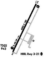
Runways
Runway Summary
| Runways: | 03/21 |
| Longest Runway: | 03/21 is 5498 ft (1676 m) long |
| Runways with an Instrument Approach: |
27K Airport Runway Details
| Runway 03/21 | 5498 ft x 100 ft (1676 m x 30 m) | |
| Runway Length Source: | 3RD PARTY SURVEY as of 10/17/2018 | |
| Surface: | Asphalt - Good condition - No special surface treatment | |
| Runway Pavement Class: | 40 /F/C/X/T | |
| Runway Edge Lights: | Medium Intensity | |
Runway Weight Bearing Capacity (in thousands of pounds) |
||
| Single Wheel Landing Gear: | 102.0 | |
| Dual Wheel Landing Gear: | 143.0 | |
Runway 03 |
Runway 21 |
|
Elevation: |
931.1 | 947.7 |
Latitude: |
38-13-39.4704N | 38-14-28.4554N |
Longitude: |
084-26-19.7773W | 084-25-49.9424W |
|
Runway True Alignment: |
026 | 206 |
Glide Path Angle: |
3.0 degrees | 3.0 degrees |
Runway Markings Type: |
Nonprecision Instrument | Nonprecision Instrument |
Runway Markings Condition: |
Fair | Fair |
Visual Glide Slope Indicators: |
2-Light PAPI On Left Side Of Runway | 2-Light PAPI On Left Side Of Runway |
REIL: |
Yes | Yes |
Threshold Crossing Height: |
33 | 30 |
Services
Airframe Repair: |
Major |
Powerplant Repair: |
Major |
Bottled Oxygen: |
None |
Bulk Oxygen: |
None |
Fuel Available: |
100LL, Jet A |
Landing Fees: |
No |
Parking: |
Hangars and tiedowns available |
Maps & Diagrams
27K Sectional
Flight Planning
at skyvector.com
at skyvector.com