Location
Latitude: |
40-47-26.1890N (40.790608) |
Longitude: |
083-49-44.7740W (-83.829104) |
Elevation: |
949.0 feet MSL (289 m MSL) |
Magnetic Variation: |
6.8 W (as of April 2024 from WMM2020 model) |
Time Zone: |
UTC -5.0 (Standard Time) UTC -4.0 (Daylight Savings Time) |
From City: |
01 N.M. N of Ada, Ohio |
Found On: |
Detroit Chart |
FAA Region: |
AGL |
Contacts
Manager: |
Privately owned: |
| KEVIN A MIERZEJEWSKI 2646 TOWNSHIP ROAD 30 ADA, OH 45810-9413 419-649-4184 |
KEVIN A MIERZEJEWSKI 1665 PEVEE RD ADA, OH 45810-9211 618-351-9768 |
Operations
Airport Status: |
Operational |
Facility Use: |
Public |
Type: |
Airport |
Control tower: |
No |
Attendance (Months/Days/Hours): |
Months/Days/Hours Unattended |
Boundary ARTCC: |
ZID (Indianapolis) |
Responsible ARTCC: |
ZID (Indianapolis) |
Segmented Circle Indicator: |
No |
Traffic Pattern Altitude (MSL): |
1949 feet (594 m) |
NOTAMs Facility: |
DAY |
NOTAM-D Service: |
Yes |
International Airport of Entry: |
No |
Customs Landing Rights: |
No |
Military Landing Rights: |
No |
Civil/Military Joint Use: |
No |
Based Aircraft
| Ultralights: | 1 |
Annual Operations (as of 09/15/2023)
| Total Operations: | 555 | |
| GA Local: | 500 | 90.1% |
| GA Itinerant: | 50 | 9.0% |
| Military Aircraft: | 5 | 0.9% |
Communications
| CTAF: | 122.800 |
| Unicom: | 122.800 |
Fixed Based Operators (FBOs) & Fuel
(Click on a business for detail)
Please help us keep this information up to date. This is a FREE SERVICE just like everything else on Airport Guide! If you see that a business needs to be added, modified, or deleted please fill out our Update Form.
To add, modify, or delete a business click here.
Please help us keep this information up to date. This is a FREE SERVICE just like everything else on Airport Guide! If you see that a business needs to be added, modified, or deleted please fill out our Update Form.
Area Code: 419 |
| Business Name | Frequency | Phone | Fuel Grade |
|---|---|---|---|
| ADA Airport
Update FBO info |
634-9538 |
Flight Service Stations
| Primary | Alternate | |
| FSS on Field: | N | |
| FSS Name (ID): | Dayton(DAY) | |
| Frequency: | ||
| Toll Free Phone: | 1-800-WX-BRIEF |
Instrument Procedures / Charts
Terminal Procedures are only available for airports in several countries with more being added all the time. If you are looking for a specific country's charts, please send an email to support(at)airportguide.com stating the country name. This will be used to prioritize the implementation.
Navigation Aids (Navaids) near 0D7
| Dist (NM) | ID | Morse Code | Name | Type | Freq | True Hdg | Mag Hdg |
|---|---|---|---|---|---|---|---|
| 8.1 | AOH | . _ _ _ _ . . . . | Allen County | VOR | 108.40 | 231 | 238 |
| 10.4 | FBC | . . _ . _ . . . _ . _ . | Flag City | VORTAC | 108.20 | 18 | 25 |
| 15.6 | BNR | _ . . . _ . . _ . | Benton Ridge | NDB | 334 | 27 | 34 |
| 21.2 | RUV | . _ . . . _ . . . _ | Rushsylvania | NDB | 326 | 159 | 166 |
| 30.9 | FZI | . . _ . _ _ . . . . | Fostoria | NDB | 379 | 39 | 46 |
| 31.7 | ROD | . _ . _ _ _ _ . . | Rosewood | VORTAC | 117.50 | 197 | 204 |
| 33.3 | TII | _ . . . . | Tiffin | NDB | 269 | 56 | 63 |
| 35.9 | VFU | . . . _ . . _ . . . _ | Stanley | NDB | 411 | 277 | 284 |
| 36.3 | BUD | _ . . . . . _ _ . . | Buckeye | VOR | 109.80 | 106 | 113 |
| 38.3 | CQA | _ . _ . _ _ . _ . _ | Lakefield | NDB | 205 | 241 | 248 |
| 40.6 | VWV | . . . _ . _ _ . . . _ | Waterville | VOR-DME | 113.10 | 12 | 19 |
| 46.0 | TO | _ _ _ _ | Tophr | NDB | 219 | 354 | 361 |
| 48.2 | TOL | _ _ _ _ . _ . . | Toledo | TACAN | 112.50 | 1 | 8 |
| 51.0 | USE | . . _ . . . . | Fulton | NDB | 375 | 344 | 351 |
| 51.8 | OS | _ _ _ . . . | Fuler | NDB | 515 | 145 | 152 |
| 53.2 | DQN | _ . . _ _ . _ _ . | Dayton | VOR-DME | 114.50 | 209 | 216 |
| 55.1 | CCJ | _ . _ . _ . _ . . _ _ _ | Clark County | NDB | 341 | 177 | 184 |
| 56.4 | DAY | _ . . . _ _ . _ _ | Dayton J M Cox-Day | VOT | 111.00 | 198 | 205 |
| 56.4 | MFD | _ _ . . _ . _ . . | Mansfield | VORTAC | 108.80 | 84 | 91 |
| 57.2 | XSF | _ . . _ . . . . . _ . | Springfield | TACAN | 133.80 | 180 | 187 |
Nearby Airports with Fuel
Notices to Airmen (NOTAMS)
Remarks
| A110-1 | DEER, BIRDS, & WILDLIFE ON & INVOF ARPT. |
| A110-2 | FOR CD CTC INDIANAPOLIS ARTCC AT 317-247-2411. |
| A110-4 | ULTRALIGHT ACT ON & INVOF ARPT. |
| A30-09/27 | NGT OPS RSTRD. |
| A53-27 | +36 FT MKD PLINE 700 FT FM RWY 27 THR. |
| A57-09 | +60 FT TREE, 0 FT DIST, 90 FT L. |
| A57-27 | +47 FT TREE, 0 FT DIST, 110 FT R. |
| E111 | ESTABD BFR 1959. |
Runways
Runway Summary
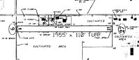
| Runways: | 09/27 |
| Longest Runway: | 09/27 is 1955 ft (596 m) long |
| Runways with an Instrument Approach: |
0D7 Airport Runway Details
| Runway 09/27 | 1955 ft x 110 ft (596 m x 34 m) | |
| Surface: | Turf - Fair condition - No special surface treatment | |
Runway 09 |
Runway 27 |
|
Elevation: |
949.0 | 949.0 |
Latitude: |
40-47-26.1700N | 40-47-26.1700N |
Longitude: |
083-49-57.5100W | 083-49-31.8300W |
Glide Path Angle: |
0.0 degrees | 0.0 degrees |
Traffic Pattern: |
Left | Left |
Runway Markings Type: |
None | None |
Object at End: |
TREE | TREE |
Object Height: |
60 | 47 |
Distance from End: |
0 | 0 |
Object Centerline Offset: |
90 ft. left of centerline | 110 ft. right of centerline |
REIL: |
No | No |
Touchdown Lights: |
No | No |
Centerline Lights: |
No | No |
Services
Airframe Repair: |
Minor |
Powerplant Repair: |
Minor |
Fuel Available: |
80, 100LL |
Landing Fees: |
No |
Parking: |
Tiedowns available |
Maps & Diagrams
0D7 Sectional
Flight Planning
at skyvector.com
at skyvector.com