
Location
Latitude: |
51-06-50.0372N (51.113899) |
Longitude: |
114-01-11.9879W (-114.019997) |
Elevation: |
3557 feet MSL (1084 m MSL) |
Magnetic Variation: |
13.6 E (as of April 2024 from WMM2020 model) |
Time Zone: |
UTC -7.0 (Standard Time) UTC -6.0 (Daylight Savings Time) |
Contacts
Manager: |
: |
Operations
Airport Status: |
Operational |
Facility Use: |
Public |
Type: |
Airport |
Traffic Pattern Altitude (MSL): |
4557 feet (1389 m) |
Based Aircraft
Annual Operations (as of )
Communications
| CTAF/UNICOM: | 122.8 |
| CTAF/UNICOM: | 122.8 |
| BURLINGTON RDO: | 122.5 |
| CTAF/UNICOM: | 122.8 |
| Edmonton Radio (FISE): | 123.375 |
| CTAF/UNICOM: | 122.8 |
| CTAF/UNICOM: | 122.8 |
| UNICOM: | 122.95 |
| GREEN BAY RDO: | 109.2 |
| CTAF/UNICOM: | 122.8 |
| CTAF/UNICOM: | 123.05 |
| CTAF/UNICOM: | 122.8 |
| Calgary Tower, (E): | 118.875 |
| TWR: | 126.05 |
| TWR: | 133.2 |
| Calgary Tower, (E): | 236.6 |
| Calgary Tower, (W): | 118.4 |
| Automatic Terminal Information System: | 128.225 |
| South Ground: | 121.9 |
| GND: | 25.112 |
| GND: | 121.6 |
| Apron I, 12-07Z: | 121.3 |
| Apron II, 12-08Z: | 129.7 |
| North Ground: | 125.35 |
| APP: | 37.915 |
| ROCKFORD APP/DEP: | 126 |
| APP: | 125.1 |
| HOUSTON APP DEP: | 134.45 |
| WICHITA APP/DEP: | 134.85 |
| DEP: | 120.9 |
| Calgary Departures: | 119.8 |
| ATIS: | 135.575 |
| AWOS 3: | 118.325 |
| AWOS 1: | 118.025 |
| AWOS 3: | 118.375 |
| AWOS 3: | 118.275 |
| MINNEAPOLIS CNTR: | 134 |
| Calgary Arrivals: | 126.525 |
| ANG OPS: | 142.2 |
| MINNEAPOLIS CNTR: | 133.65 |
| Calgary Arrivals (E): | 125.9 |
| ARNG OPS: | 41 |
| KANSAS CITY CNTR: | 134 |
| HOUSTON AIR: | 38.18 |
| COMD POST: | 142.2 |
| Calgary Clearance: | 120.825 |
| MINNEAPOLIS CNTR: | 127.75 |
| DENVER CNTR: | 127.95 |
| COMD POST: | 150.6 |
| Edmonton Centre: | 124.525 |
| VFR Advisories: | 119.4 |
| Calgary Arrivals (W): | 123.85 |
| Edmonton Centre: | 133.3 |
| PTD: | 139.3 |
Fixed Based Operators (FBOs) & Fuel
(Click on a business for detail)
Please help us keep this information up to date. This is a FREE SERVICE just like everything else on Airport Guide! If you see that a business needs to be added, modified, or deleted please fill out our Update Form.
To add, modify, or delete a business click here.
Please help us keep this information up to date. This is a FREE SERVICE just like everything else on Airport Guide! If you see that a business needs to be added, modified, or deleted please fill out our Update Form.
| Business Name | Frequency | Phone | Fuel Grade |
|---|
Flight Service Stations
| Primary | Alternate | |
| FSS on Field: | ||
| FSS Name (ID): | ||
| Frequency: | ||
| Toll Free Phone: |
Instrument Procedures / Charts
Terminal Procedures are only available for airports in several countries with more being added all the time. If you are looking for a specific country's charts, please send an email to support(at)airportguide.com stating the country name. This will be used to prioritize the implementation.
Navigation Aids (Navaids) near YYC
| Dist (NM) | ID | Morse Code | Name | Type | Freq | True Hdg | Mag Hdg |
|---|---|---|---|---|---|---|---|
| 0.9 | IYC | Calgary | DME | 111.50 | 187 | 173 | |
| 4.6 | YC | Calgary | NDB | 344 | 115 | 101 | |
| 4.8 | ZCA | Blackfoot | NDB | 233 | 180 | 166 | |
| 5.0 | ZYC | Sarcee | NDB | 254 | 359 | 345 | |
| 5.2 | YYC | _ . _ _ _ . _ _ _ . _ . | Calgary | VOR-DME | 116.70 | 89 | 75 |
| 23.4 | JW | Pigeon | NDB | 388 | 260 | 246 | |
| 25.5 | TV | Turner Valley | NDB | 299 | 211 | 197 | |
| 35.9 | K2 | Olds-Didsbury | NDB | 376 | 354 | 340 | |
| 46.1 | Z1 | Three Hills | NDB | 305 | 40 | 27 | |
| 47.0 | 9G | Sundre | NDB | 405 | 328 | 314 | |
| 51.3 | Z5 | Vulcan | NDB-DME | 274 | 146 | 133 | |
| 53.0 | 5V | Drumheller | NDB-DME | 395 | 63 | 50 | |
| 61.0 | YQF | Red Deer | NDB | 320 | 4 | 350 | |
| 64.2 | 6G | Red Deer | DME | 111.60 | 4 | 350 | |
| 68.2 | Z7 | Claresholm | NDB | 408 | 167 | 154 | |
| 83.4 | 5M | Sparwood | NDB | 200 | 203 | 189 | |
| 84.5 | 9X | Brooks | NDB-DME | 227 | 109 | 96 | |
| 84.9 | D6 | Fairmont Hot Springs | NDB-DME | 261 | 236 | 222 | |
| 85.1 | 9A | Hanna | NDB | 221 | 67 | 54 | |
| 85.7 | 8G | Stettler | NDB-DME | 286 | 32 | 19 |
Nearby Airports with Fuel
| Dist (NM) | Name (Airport IDs) | True Hdg | Mag Hdg | Fuel Grade |
|---|---|---|---|---|
| 13.4 | Calgary / Springbank Airport (YBW CYBW YBW) |
267 | 253 | 100LL, Jet A |
| 85.5 | Rocky Mountain House Airport (YRM CYRM CYRM) |
337 | 323 | 100LL, Jet A |
Notices to Airmen (NOTAMS)
Remarks
No remarks for this landing facility
Runways
Runway Summary
| Runways: | 08/26 11/29 17L/35R 17R/35L |
| Longest Runway: | 17L/35R is 14000 ft (4267 m) long |
| Runways with an Instrument Approach: |
YYC Airport Runway Details
| Runway 08/26 | 6200 ft x 150 ft (1890 m x 46 m) | |
| Runway Edge Lights: | Yes Intensity | |
Runway 08 |
Runway 26 |
|
Elevation: |
3531 | 3557 |
Latitude: |
51.10419845581 | 51.10419845581 |
Longitude: |
-114.0299987792 | -114.0029983520 |
|
Runway True Alignment: |
90 | 270 |
Glide Path Angle: |
0.0 degrees | 0.0 degrees |
REIL: |
Yes | Yes |
Threshold Elevation: |
3531 | 3557 |
| Runway 11/29 | 8000 ft x 200 ft (2438 m x 61 m) | |
| Runway Edge Lights: | Yes Intensity | |
Runway 11 |
Runway 29 |
|
Elevation: |
3547 | 3542 |
Latitude: |
51.12639999389 | 51.11560058593 |
Longitude: |
-114.0370025634 | -114.0059967041 |
|
Runway True Alignment: |
119.5 | 299.5 |
Glide Path Angle: |
0.0 degrees | 0.0 degrees |
REIL: |
Yes | Yes |
Threshold Elevation: |
3547 | 3542 |
| Runway 17L/35R | 14000 ft x 200 ft (4267 m x 61 m) | |
| Runway Edge Lights: | Yes Intensity | |
Runway 17L |
Runway 35R |
|
Elevation: |
3606 | 3577 |
Latitude: |
51.14830017089 | 51.11000061035 |
Longitude: |
-113.9899978637 | -113.9899978637 |
|
Runway True Alignment: |
180 | 0 |
Glide Path Angle: |
0.0 degrees | 0.0 degrees |
REIL: |
Yes | Yes |
Threshold Elevation: |
3606 | 3577 |
| Runway 17R/35L | 12675 ft x 200 ft (3863 m x 61 m) | |
| Runway Edge Lights: | Yes Intensity | |
Runway 17R |
Runway 35L |
|
Elevation: |
3556 | 3543 |
Latitude: |
51.13140106201 | 51.09659957885 |
Longitude: |
-114.0210037231 | -114.0210037231 |
|
Runway True Alignment: |
180 | 360 |
Glide Path Angle: |
0.0 degrees | 0.0 degrees |
REIL: |
Yes | Yes |
Threshold Elevation: |
3556 | 3543 |
Services
Fuel Available: |
100LL, Jet A |
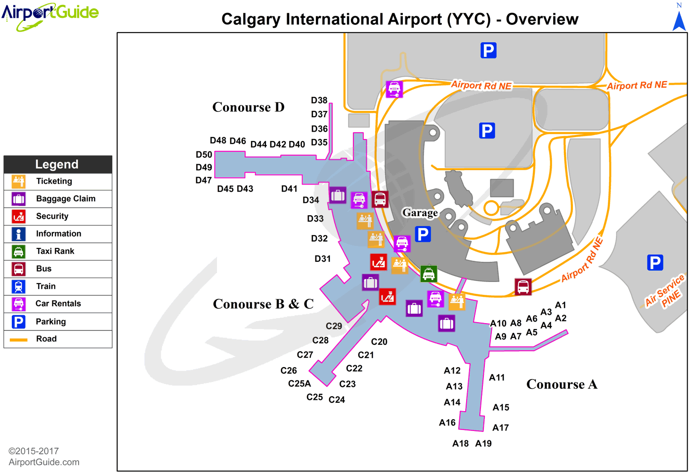
Maps & Diagrams
YYC Sectional
Flight Planning
at skyvector.com
at skyvector.com
