Location
Latitude: |
32-44-46.6321N (32.746287) |
Longitude: |
097-40-56.8279W (-97.682452) |
Elevation: |
991.2 feet MSL (302 m MSL) |
Magnetic Variation: |
3.2 E (as of April 2024 from WMM2020 model) |
Time Zone: |
UTC -6.0 (Standard Time) UTC -5.0 (Daylight Savings Time) |
From City: |
05 N.M. E of Weatherford, Texas |
Found On: |
Dallas-Ft Worth Chart |
FAA Region: |
ASW |
Contacts
Manager: |
Privately owned: |
| BRET PRIVITT 4607 FOREST HILL CIRCLE FORT WORTH, TX 76140 (817) 822-7205 |
PARKER COUNTY AIRPORT HANGARS ASSOC 4607 FOREST HILL CIRCLE FORT WORTH, TX 76140 817-599-9210 |
Operations
Airport Status: |
Operational |
Facility Use: |
Public |
Type: |
Airport |
Activation Date: |
01/1961 |
Control tower: |
No |
Attendance (Months/Days/Hours): |
Months/Days/Hours ALL/ALL/0800-1800 |
Boundary ARTCC: |
ZFW (Fort Worth) |
Responsible ARTCC: |
ZFW (Fort Worth) |
Lighting Schedule: |
SS-SR |
Segmented Circle Indicator: |
No |
Traffic Pattern Altitude (MSL): |
1991 feet (607 m) |
NOTAMs Facility: |
FTW |
NOTAM-D Service: |
Yes |
International Airport of Entry: |
No |
Customs Landing Rights: |
No |
Military Landing Rights: |
No |
Civil/Military Joint Use: |
No |
Based Aircraft
| Single Engine: | 80 |
| Multi Engine: | 6 |
Annual Operations (as of 09/21/2022)
| Total Operations: | 50040 | |
| GA Local: | 37500 | 74.9% |
| GA Itinerant: | 12500 | 25.0% |
| Military Aircraft: | 40 | 0.1% |
Communications
| CTAF: | 122.700 |
| Unicom: | 122.700 |
| Approach: | REGIONAL |
| Departure: | REGIONAL |
Fixed Based Operators (FBOs) & Fuel
(Click on a business for detail)
Please help us keep this information up to date. This is a FREE SERVICE just like everything else on Airport Guide! If you see that a business needs to be added, modified, or deleted please fill out our Update Form.
To add, modify, or delete a business click here.
Please help us keep this information up to date. This is a FREE SERVICE just like everything else on Airport Guide! If you see that a business needs to be added, modified, or deleted please fill out our Update Form.
Area Code: 817 |
| Business Name | Frequency | Phone | Fuel Grade |
|---|---|---|---|
| Parker County Aviation
Update FBO info |
599-7772, 594-5691 | 80 |
Flight Service Stations
| Primary | Alternate | |
| FSS on Field: | N | |
| FSS Name (ID): | Fort Worth(FTW) | |
| Frequency: | ||
| Toll Free Phone: | 1-800-WX-BRIEF |
Instrument Procedures / Charts
FAA Terminal Procedures valid from 0901Z 03/21/24 to 0901Z 04/18/24.
There are various types of charts available for an airport. They are listed in the Page Type column. Here is a legend for those types:
APD - Airport Diagram
DP - Departure Procedure Charts
HOT - Hot Spots
IAP - Instrument Approach Procedure Charts
MIN - Minimums
STAR - Standard Terminal Arrival Charts
| Page Type | Page Name | Volume | Action Since Last Cycle |
|---|---|---|---|
| DP | GARLAND FIVE | SC-2 | |
| DP | GARLAND FIVE[DELIMITER] CONT.1 | SC-2 | |
| DP | KINGDOM FOUR | SC-2 | |
| DP | KINGDOM FOUR[DELIMITER] CONT.1 | SC-2 | |
| DP | KUSSO ONE (RNAV) | SC-2 | |
| DP | KUSSO ONE (RNAV)[DELIMITER] CONT.1 | SC-2 | |
| DP | NANDR TWO (RNAV) | SC-2 | |
| DP | NANDR TWO (RNAV)[DELIMITER] CONT.1 | SC-2 | |
| DP | SWABR ONE (RNAV) | SC-2 | |
| DP | SWABR ONE (RNAV)[DELIMITER] CONT.1 | SC-2 | |
| IAP | VOR/DME-A | SC-2 | |
| MIN | TAKEOFF MINIMUMS | SC-2 | |
| STAR | LIKES THREE (RNAV) | SC-2 | |
| STAR | MOTZA ONE | SC-2 | |
| STAR | MOTZA ONE[DELIMITER] CONT.1 | SC-2 | |
| STAR | REEKO THREE (RNAV) | SC-2 | |
| STAR | SASIE SEVEN | SC-2 | |
| STAR | SASIE SEVEN[DELIMITER] CONT.1 | SC-2 | |
| STAR | TRUUK TWO (RNAV) | SC-2 | |
| STAR | WESAT TWO (RNAV) | SC-2 |
Terminal Procedures are only available for airports in several countries with more being added all the time. If you are looking for a specific country's charts, please send an email to support(at)airportguide.com stating the country name. This will be used to prioritize the implementation.
Navigation Aids (Navaids) near WEA
| Dist (NM) | ID | Morse Code | Name | Type | Freq | True Hdg | Mag Hdg |
|---|---|---|---|---|---|---|---|
| 12.4 | NFW | _ . . . _ . . _ _ | Nas Jrb Fort Worth | TACAN | 108.70 | 82 | 79 |
| 15.9 | MQP | _ _ _ _ . _ . _ _ . | Millsap | VORTAC | 117.70 | 265 | 262 |
| 16.7 | FTW | . . _ . _ . _ _ | Fort Worth | VOT | 108.20 | 74 | 71 |
| 17.9 | FT | . . _ . _ | Mufin | NDB | 365 | 60 | 57 |
| 26.8 | FUZ | . . _ . . . _ _ _ . . | Ranger | VORTAC | 115.70 | 71 | 68 |
| 33.2 | TTT | _ _ _ | Maverick | VOR-DME | 113.10 | 76 | 73 |
| 36.6 | JEN | . _ _ _ . _ . | Glen Rose | TACAN | 115.00 | 195 | 192 |
| 40.2 | CVE | _ . _ . . . . _ . | Cowboy | VOR-DME | 116.20 | 77 | 74 |
| 40.4 | DT | _ . . _ | Pinck | NDB | 257 | 37 | 34 |
| 42.6 | DAL | _ . . . _ . _ . . | Dallas | VOT | 113.30 | 80 | 77 |
| 47.9 | UKW | . . _ _ . _ . _ _ | Bowie | VORTAC | 117.15 | 351 | 348 |
| 48.1 | GHX | _ _ . . . . . _ . . _ | Graham | NDB | 371 | 301 | 298 |
| 51.8 | GMZ | _ _ . _ _ _ _ . . | Grindstone Mountain | NDB | 356 | 354 | 351 |
| 58.3 | JUG | . _ _ _ . . _ _ _ . | Jecca | NDB | 388 | 94 | 91 |
| 58.3 | PQF | . _ _ . _ _ . _ . . _ . | Mesquite | NDB | 248 | 85 | 82 |
| 60.7 | OIP | _ _ _ . . . _ _ . | Old Rip | NDB | 410 | 250 | 247 |
| 63.1 | VLY | . . . _ . _ . . _ . _ _ | Melisa | NDB | 421 | 60 | 57 |
| 68.3 | ACT | . _ _ . _ . _ | Waco | VORTAC | 115.30 | 162 | 159 |
| 71.5 | MNZ | _ _ _ . _ _ . . | Hamilton | NDB | 251 | 199 | 196 |
| 72.3 | AVZ | . _ . . . _ _ _ . . | Travis | NDB | 260 | 88 | 85 |
Nearby Airports with Fuel
Notices to Airmen (NOTAMS)
Remarks
| A110*G | THIS AIRPORT HAS BEEN SURVEYED BY THE NATIONAL GEODETIC SURVEY. |
| A110-10 | FOR CD CTC REGIONAL APCH AT 972-615-2799. |
| A110-2 | WILDLIFE ON AND INVOF APRT. |
| A110-4 | TWY ON WEST SIDE OF RWY CLSD TO PUBLIC INDEFLY. |
| A110-5 | ARPT CLSD TO TRANSIENT STUDENT TFC. |
| A110-9 | CLOSED TO ULTRALIGHT TRAFFIC. |
| A30-17/35 | RESTRICTED TO ACFT 7500 LBS OR LESS. |
| A40-17/35 | NSTD DSPLCD THR LGTS, SINGLE GREEN LGT EACH SIDE OF RWY. |
| A57-17 | APCH RATIO 18:1 AT DSPLCD THR. |
| A57-35 | APCH SLOPE 20:1 AT DSPLCD THR. |
| A58-17 | 5 FT FENCE 40 FT FM THR 120 FT R OF CNTRLN; 20 FT DROP-OFF 10 FT FROM THR 0B. |
| A70-FUEL-10 | 0LL FUEL 24 HRS SELF SERVE. |
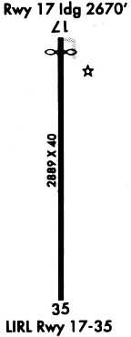
Runways
Runway Summary
| Runways: | 17/35 |
| Longest Runway: | 17/35 is 2892 ft (881 m) long |
| Runways with an Instrument Approach: |
WEA Airport Runway Details
| Runway 17/35 | 2892 ft x 40 ft (881 m x 12 m) | |
| Runway Length Source: | NGS as of 02/23/1995 | |
| Surface: | Asphalt - Good condition - No special surface treatment | |
| Runway Edge Lights: | Low Intensity | |
Runway Weight Bearing Capacity (in thousands of pounds) |
||
| Single Wheel Landing Gear: | 7.5 | |
Runway 17 |
Runway 35 |
|
Elevation: |
988.6 | 982.6 |
Latitude: |
32-45-00.9379N | 32-44-32.3263N |
Longitude: |
097-40-56.7174W | 097-40-56.9384W |
|
Runway True Alignment: |
180 | 000 |
Glide Path Angle: |
0.0 degrees | 0.0 degrees |
Traffic Pattern: |
Left | Left |
Runway Markings Type: |
Basic | Basic |
Runway Markings Condition: |
Good | Good |
Object at End: |
TREE | TREES |
Object Height: |
40 | 40 |
Distance from End: |
526 | 400 |
Object Centerline Offset: |
44 ft. left of centerline | 125 ft. right of centerline |
Threshold Elevation: |
988.4 | |
Displaced Threshold: |
220 | |
Threshold Latitude: |
32-44-58.7618N | |
Threshold Longitude: |
097-40-56.7342W |
Services
Airframe Repair: |
Major |
Powerplant Repair: |
Major |
Fuel Available: |
100LL, Jet A |
Parking: |
Tiedowns available |
Maps & Diagrams
WEA Sectional
Flight Planning
at skyvector.com
at skyvector.com