Location
Latitude: |
35-46-13.4650N (35.770407) |
Longitude: |
077-58-11.2490W (-77.969791) |
Elevation: |
159.6 feet MSL (49 m MSL) |
Magnetic Variation: |
9.8 W (as of April 2024 from WMM2020 model) |
Time Zone: |
UTC -5.0 (Standard Time) UTC -4.0 (Daylight Savings Time) |
From City: |
03 N.M. N of Wilson, North Carolina |
Found On: |
Charlotte Chart |
FAA Region: |
ASO |
Contacts
Manager: |
Publicly owned: |
| GRONNA JONES PO BOX 10 WILSON, NC 27894 252-399-2489 |
CITY OF WILSON PO BOX 10 WILSON, NC 27894 252-399-2489 |
Operations
Airport Status: |
Operational |
Facility Use: |
Public |
Type: |
Airport |
Activation Date: |
05/1943 |
Control tower: |
No |
Attendance (Months/Days/Hours): |
Months/Days/Hours ALL/ALL/0800-1800 |
Boundary ARTCC: |
ZDC (Washington) |
Responsible ARTCC: |
ZDC (Washington) |
Lighting Schedule: |
SEE RMK |
Segmented Circle Indicator: |
No |
Traffic Pattern Altitude (MSL): |
1160 feet (354 m) |
NOTAMs Facility: |
RDU |
NOTAM-D Service: |
Yes |
International Airport of Entry: |
No |
Customs Landing Rights: |
No |
Military Landing Rights: |
Yes |
Civil/Military Joint Use: |
No |
Based Aircraft
| Single Engine: | 23 |
| Multi Engine: | 1 |
| Jet Engine: | 1 |
| GA Helicopters: | 2 |
Annual Operations (as of 03/13/2021)
| Total Operations: | 12400 | |
| Air Taxi: | 700 | 5.6% |
| GA Local: | 5000 | 40.3% |
| GA Itinerant: | 6000 | 48.4% |
| Military Aircraft: | 700 | 5.6% |
Communications
| CTAF: | 123.000 |
| Unicom: | 123.000 |
- COMMUNICATIONS PRVDD BY RALEIGH RADIO ON FREQ 122.2 (ROCKY MOUNT RCO)
- APCH/DEP SVC PRVDD BY WASHINGTON ARTCC (ZDC) ON 123.85/279.65 (NEW BERN RCAG).
Fixed Based Operators (FBOs) & Fuel
(Click on a business for detail)
Please help us keep this information up to date. This is a FREE SERVICE just like everything else on Airport Guide! If you see that a business needs to be added, modified, or deleted please fill out our Update Form.
To add, modify, or delete a business click here.
Please help us keep this information up to date. This is a FREE SERVICE just like everything else on Airport Guide! If you see that a business needs to be added, modified, or deleted please fill out our Update Form.
Area Code: 252 |
| Business Name | Frequency | Phone | Fuel Grade |
|---|---|---|---|
| Air Care, Inc.
Update FBO info |
Unicom 123.0 | 291-8810 | 100LL, Jet A |
Flight Service Stations
| Primary | Alternate | |
| FSS on Field: | N | |
| FSS Name (ID): | Raleigh(RDU) | |
| Frequency: | ||
| Toll Free Phone: | 1-800-WX-BRIEF |
Instrument Procedures / Charts
FAA Terminal Procedures valid from 0901Z 03/21/24 to 0901Z 04/18/24.
There are various types of charts available for an airport. They are listed in the Page Type column. Here is a legend for those types:
APD - Airport Diagram
DP - Departure Procedure Charts
HOT - Hot Spots
IAP - Instrument Approach Procedure Charts
MIN - Minimums
STAR - Standard Terminal Arrival Charts
| Page Type | Page Name | Volume | Action Since Last Cycle |
|---|---|---|---|
| IAP | RNAV (GPS) RWY 03 | SE-2 | |
| IAP | RNAV (GPS) RWY 09 | SE-2 | |
| IAP | RNAV (GPS) RWY 15 | SE-2 | |
| IAP | RNAV (GPS) RWY 21 | SE-2 | |
| IAP | RNAV (GPS) RWY 33 | SE-2 | |
| MIN | TAKEOFF MINIMUMS | SE-2 |
Terminal Procedures are only available for airports in several countries with more being added all the time. If you are looking for a specific country's charts, please send an email to support(at)airportguide.com stating the country name. This will be used to prioritize the implementation.
Navigation Aids (Navaids) near W03
| Dist (NM) | ID | Morse Code | Name | Type | Freq | True Hdg | Mag Hdg |
|---|---|---|---|---|---|---|---|
| 17.9 | TYI | _ _ . _ _ . . | Tar River | VORTAC | 117.80 | 46 | 56 |
| 22.9 | ETC | . _ _ . _ . | Tarboro | NDB | 257 | 64 | 74 |
| 26.1 | GSB | _ _ . . . . _ . . . | Seymour Johnson | TACAN | 116.50 | 180 | 190 |
| 28.4 | JN | . _ _ _ _ . | Jurly | NDB | 263 | 231 | 241 |
| 29.4 | AQE | . _ _ _ . _ . | Alwood | NDB | 230 | 97 | 107 |
| 29.7 | PGV | . _ _ . _ _ . . . . _ | Belvoir | FAN MARKER | 105 | 115 | |
| 31.3 | ISO | . . . . . _ _ _ | Kinston | VORTAC | 117.50 | 139 | 149 |
| 34.3 | IS | . . . . . | Stals | NDB | 276 | 157 | 167 |
| 37.8 | LE | . _ . . . | Leevy | NDB | 350 | 284 | 294 |
| 38.9 | MCZ | _ _ _ . _ . _ _ . . | Williamston | NDB | 336 | 81 | 91 |
| 39.9 | HQT | . . . . _ _ . _ _ | Harnett | NDB | 417 | 239 | 249 |
| 40.0 | RDU | . _ . _ . . . . _ | Raleigh/Durham | VORTAC | 117.20 | 279 | 289 |
| 42.0 | DKA | _ . . _ . _ . _ | Kenan | NDB | 332 | 176 | 186 |
| 42.2 | RZZ | . _ . _ _ . . _ _ . . | Rapids | NDB | 407 | 17 | 27 |
| 44.8 | HXO | . . . . _ . . _ _ _ _ | Huntsboro | NDB | 271 | 315 | 325 |
| 44.9 | RNW | . _ . _ . . _ _ | Chocowinity | NDB | 388 | 110 | 120 |
| 50.8 | AEA | . _ . . _ | Jones | NDB | 373 | 355 | 365 |
| 51.4 | CTZ | _ . _ . _ _ _ . . | Clinton | NDB | 412 | 202 | 212 |
| 55.5 | MBV | _ _ _ . . . . . . _ | Mecklenburg/Dcmsnd | NDB | 356 | 355 | 365 |
| 56.0 | FGP | . . _ . _ _ . . _ _ . | Fort Bragg | NDB | 393 | 227 | 237 |
Nearby Airports with Fuel
Notices to Airmen (NOTAMS)
Remarks
| A110-1 | NO LINE-OF-SIGHT BTN RY ENDS. |
| A110-2 | DEER ON & INVOF ARPT. |
| A110-3 | FOR CD CTC WASHINGTON ARTCC AT 703-771-3587. |
| A16 | ARPT PHONE NR 252-991-6336. |
| A17 | FOR SVC AFTER HOURS CALL 252-292-8443. |
| A33-09/27 | ROUGH SFC DUE TO EXCESSIVE CRACK SEALANT. |
| A33-15/33 | L & T AND BLOCK CRACKING, FOD, FAILED SEALANT. |
| A42-09 | DUE TO LINE UNDER RUNWAY NUMBER AND LOCATION FROM END. |
| A42-15 | DUE TO LINE UNDER RUNWAY NUMBER AND LOCATION FROM END. |
| A48-03 | RWY 03/21 OTS INDEF |
| A58-09 | DUE TO 23 FT TREES 0-200 FT FROM END AND OFFSET 120 FT RIGHT OF CNTRLN. |
| A58-15 | DUE TO 25 FT TREES 0-200 FT FROM END AND OFFSET 168 FT LEFT OF CNTRLN. |
| A58-33 | DUE TO 20 FT BUILDING 5 FT FROM END AND OFFSET 243 FT RIGHT OF CNTRLN. |
| A75 | CALL FOR AVAILABILITY |
| A81-APT | ACTVT REIL RYS 03/21; MIRL RYS 03/21. - CTAF. |
Runways
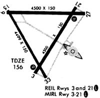
Runway Summary
| Runways: | 03/21 09/27 15/33 |
| Longest Runway: | 03/21 is 4500 ft (1372 m) long |
| Runways with an Instrument Approach: |
W03 Airport Runway Details
| Runway 03/21 | 4500 ft x 150 ft (1372 m x 46 m) | |
| Runway Length Source: | 3RD PARTY SURVEY as of 11/10/2011 | |
| Surface: | Asphalt - Fair condition - No special surface treatment | |
| Runway Edge Lights: | Medium Intensity | |
Runway Weight Bearing Capacity (in thousands of pounds) |
||
| Single Wheel Landing Gear: | 20.0 | |
Runway 03 |
Runway 21 |
|
Elevation: |
155.5 | 154.8 |
Latitude: |
35-45-50.0598N | 35-46-28.3992N |
Longitude: |
077-58-16.3672W | 077-57-48.6402W |
|
Runway True Alignment: |
031 | 211 |
Glide Path Angle: |
0.0 degrees | 0.0 degrees |
Traffic Pattern: |
Left | Left |
Runway Markings Type: |
Nonprecision Instrument | Nonprecision Instrument |
Runway Markings Condition: |
Good | Good |
Object at End: |
TREES | TREES |
Object Height: |
82 | 10 |
Distance from End: |
1987 | 312 |
Object Centerline Offset: |
216 ft. left of centerline | 91 ft. left of centerline |
REIL: |
Yes | Yes |
| Runway 09/27 | 4498 ft x 150 ft (1371 m x 46 m) | |
| Runway Length Source: | 3RD PARTY SURVEY as of 11/10/2011 | |
| Surface: | Asphalt - Fair condition - No special surface treatment | |
Runway Weight Bearing Capacity (in thousands of pounds) |
||
| Single Wheel Landing Gear: | 20.0 | |
Runway 09 |
Runway 27 |
|
Elevation: |
158.6 | 154.8 |
Latitude: |
35-46-24.4530N | 35-46-24.0728N |
Longitude: |
077-58-36.6147W | 077-57-42.0297W |
|
Runway True Alignment: |
090 | 270 |
Glide Path Angle: |
0.0 degrees | 0.0 degrees |
Traffic Pattern: |
Left | Left |
Runway Markings Type: |
Nonstandard (other than numbers only) | Numbers Only |
Runway Markings Condition: |
Good | Good |
Object at End: |
TREES | TREES |
Object Height: |
39 | 45 |
Distance from End: |
485 | 441 |
Object Centerline Offset: |
216 ft. left of centerline | 91 ft. left of centerline |
| Runway 15/33 | 4499 ft x 150 ft (1371 m x 46 m) | |
| Runway Length Source: | 3RD PARTY SURVEY as of 11/10/2011 | |
| Surface: | Asphalt - Fair condition - No special surface treatment | |
Runway Weight Bearing Capacity (in thousands of pounds) |
||
| Single Wheel Landing Gear: | 20.0 | |
Runway 15 |
Runway 33 |
|
Elevation: |
159.6 | 150.9 |
Latitude: |
35-46-26.1519N | 35-45-47.4372N |
Longitude: |
077-58-35.3929W | 077-58-08.4956W |
|
Runway True Alignment: |
150 | 330 |
Glide Path Angle: |
0.0 degrees | 0.0 degrees |
Traffic Pattern: |
Left | Left |
Runway Markings Type: |
Nonstandard (other than numbers only) | Numbers Only |
Runway Markings Condition: |
Good | Good |
Object at End: |
TREES | TREES |
Object Height: |
34 | 46 |
Distance from End: |
471 | 311 |
Object Centerline Offset: |
216 ft. left of centerline | 91 ft. left of centerline |
Services
Airframe Repair: |
Major |
Powerplant Repair: |
Major |
Bottled Oxygen: |
None |
Bulk Oxygen: |
None |
Fuel Available: |
100LL, Jet A-1+ |
Landing Fees: |
No |
Parking: |
Tiedowns available |
Maps & Diagrams
W03 Sectional
Flight Planning
at skyvector.com
at skyvector.com