Location
Latitude: |
34-23-03.6000N (34.384333) |
Longitude: |
089-32-12.5000W (-89.536806) |
Elevation: |
452.0 feet MSL (138 m MSL) |
Magnetic Variation: |
2.1 W (as of April 2024 from WMM2020 model) |
Time Zone: |
UTC -6.0 (Standard Time) UTC -5.0 (Daylight Savings Time) |
From City: |
02 N.M. NW of Oxford, Mississippi |
Found On: |
Memphis Chart |
FAA Region: |
ASO |
Contacts
Manager: |
Publicly owned: |
| JACOB PIND UNIVERSITY-OXFORD AIRPORT OXFORD, MS 38655 662-234-2036 |
UNIVERSITY OF MISSISSIPPI PO BOX 1848 UNIVERSITY, MS 38677 662-915-7044 |
Operations
Airport Status: |
Operational |
Facility Use: |
Public |
Type: |
Airport |
Activation Date: |
05/1957 |
Control tower: |
No |
Attendance (Months/Days/Hours): |
Months/Days/Hours ALL/ALL/0700-1800 |
Boundary ARTCC: |
ZME (Memphis) |
Responsible ARTCC: |
ZME (Memphis) |
Lighting Schedule: |
SEE RMK |
Segmented Circle Indicator: |
Yes |
Traffic Pattern Altitude (MSL): |
1452 feet (443 m) |
NOTAMs Facility: |
GWO |
NOTAM-D Service: |
Yes |
International Airport of Entry: |
No |
Customs Landing Rights: |
No |
Military Landing Rights: |
Yes |
Civil/Military Joint Use: |
No |
Aircraft Rescue and Firefighting: |
Class IV ARFF Index: A Air Carrier Service: Not Scheduled Certification Date: 09/1984 |
Based Aircraft
| Single Engine: | 12 |
| Multi Engine: | 7 |
| Jet Engine: | 3 |
Annual Operations (as of 02/28/2021)
| Total Operations: | 60253 | |
| Commercial: | 28 | 0.0% |
| Air Taxi: | 5146 | 8.5% |
| GA Local: | 37241 | 61.8% |
| GA Itinerant: | 16322 | 27.1% |
| Military Aircraft: | 1516 | 2.5% |
Communications
| CTAF: | 123.000 |
| Unicom: | 123.000 |
| AWOS-3PT: | 132.725 (662-234-9751) |
- APCH/DEP SVC PRVDD BY MEMPHIS ARTCC (ZME) ON FREQS 128.5/279.55 (TUPELO RCAG).
Fixed Based Operators (FBOs) & Fuel
(Click on a business for detail)
Please help us keep this information up to date. This is a FREE SERVICE just like everything else on Airport Guide! If you see that a business needs to be added, modified, or deleted please fill out our Update Form.
To add, modify, or delete a business click here.
Please help us keep this information up to date. This is a FREE SERVICE just like everything else on Airport Guide! If you see that a business needs to be added, modified, or deleted please fill out our Update Form.
Area Code: 662 |
| Business Name | Frequency | Phone | Fuel Grade |
|---|---|---|---|
| Curtis Aviation, Inc.
Update FBO info |
234-0430 | 100LL, Jet A |
Flight Service Stations
| Primary | Alternate | |
| FSS on Field: | N | |
| FSS Name (ID): | Greenwood(GWO) | |
| Frequency: | ||
| Toll Free Phone: | 1-800-WX-BRIEF |
Instrument Procedures / Charts
FAA Terminal Procedures valid from 0901Z 03/21/24 to 0901Z 04/18/24.
There are various types of charts available for an airport. They are listed in the Page Type column. Here is a legend for those types:
APD - Airport Diagram
DP - Departure Procedure Charts
HOT - Hot Spots
IAP - Instrument Approach Procedure Charts
MIN - Minimums
STAR - Standard Terminal Arrival Charts
| Page Type | Page Name | Volume | Action Since Last Cycle |
|---|---|---|---|
| IAP | LOC Y RWY 09 | SC-4 | |
| IAP | LOC Z RWY 09 | SC-4 | |
| IAP | RNAV (GPS) RWY 09 | SC-4 | |
| IAP | RNAV (GPS) RWY 27 | SC-4 | |
| IAP | VOR-A | SC-4 | |
| MIN | ALTERNATE MINIMUMS | SC-4 | |
| MIN | TAKEOFF MINIMUMS | SC-4 |
Terminal Procedures are only available for airports in several countries with more being added all the time. If you are looking for a specific country's charts, please send an email to support(at)airportguide.com stating the country name. This will be used to prioritize the implementation.
Navigation Aids (Navaids) near UOX
| Dist (NM) | ID | Morse Code | Name | Type | Freq | True Hdg | Mag Hdg |
|---|---|---|---|---|---|---|---|
| 4.4 | UV | . . _ . . . _ | Tunng | NDB | 426 | 270 | 272 |
| 23.2 | HLI | . . . . . _ . . . . | Holly Springs | VORTAC | 112.40 | 4 | 6 |
| 34.0 | SBQ | . . . _ . . . _ _ . _ | Scobey | NDB | 245 | 209 | 211 |
| 37.9 | OTB | _ _ _ _ _ . . . | Tupelo | VOR-DME | 109.80 | 104 | 106 |
| 40.0 | TU | _ . . _ | Veron | NDB | 420 | 107 | 109 |
| 43.8 | MEM | _ _ . _ _ | Memphis | VORTAC | 117.50 | 329 | 331 |
| 45.6 | MEM | _ _ . _ _ | Memphis Metropolitn | VOT | 111.00 | 331 | 333 |
| 48.4 | ME | _ _ . | Elvis | NDB | 287 | 327 | 329 |
| 49.8 | FYE | . . _ . _ . _ _ . | Somerville | NDB | 255 | 8 | 10 |
| 54.8 | GW | _ _ . . _ _ | Teock | NDB | 349 | 209 | 211 |
| 55.2 | SPQ | . . . . _ _ . _ _ . _ | Spain | NDB | 414 | 332 | 334 |
| 57.2 | MIG | _ _ . . _ _ . | Millington | NDB | 232 | 340 | 342 |
| 57.4 | UJM | . . _ . _ _ _ _ _ | Marvell | VOR-DME | 109.60 | 281 | 283 |
| 59.2 | UU | . . _ . . _ | Seyer | NDB | 334 | 49 | 51 |
| 66.4 | SQS | . . . _ _ . _ . . . | Sidon | VORTAC | 114.70 | 213 | 215 |
| 70.5 | CBM | _ . _ . _ . . . _ _ | Caledonia | VORTAC | 115.20 | 128 | 130 |
| 71.7 | SZY | . . . _ _ . . _ . _ _ | Sibley | NDB | 386 | 44 | 47 |
| 72.4 | COO | _ . _ . _ _ _ _ _ _ | Covington | NDB | 326 | 358 | 360 |
| 73.6 | MKL | _ _ _ . _ . _ . . | Mersy | NDB | 394 | 22 | 24 |
| 74.1 | GQE | _ _ . _ _ . _ . | Gilmore | VOR-DME | 113.00 | 321 | 323 |
Nearby Airports with Fuel
Notices to Airmen (NOTAMS)
Remarks
| A110-1 | GCO AVBL ON FREQ 135.075 FOR MEMPHIS ARTCC (ZME). |
| A110-2 | FOR CD IF UNA VIA GCO CTC MEMPHIS ARTCC AT 901-368-8453/8449. |
| A17 | FOR ARPT ATTENDANT NIGHTS CALL 662-234-2036. |
| A26 | CLSD TO ACR OPS WITH MORE THAN 30 PAX SEATS EXCP PPR CALL AMGR 662-234-2036. |
| A43-27 | PAPI UNUSBL BYD 6 DEG L OF CNTRLN. |
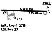
| A81-APT | MIRL RWY 09/27 OPRS DUSK-2200. AFT 2200, ACTVT REIL 09 & 27; PAPI RWY 09; MIRL RWY 09/27 - CTAF. PAPI RWY 27 OPR CONSLY. |
| E111 | PRIOR TO FAA ACT. |
| E147 | TPA: 800 FT AGL LGT ACFT, 1200 FT AGL HI SPD ACFT. |
Runways
Runway Summary
| Runways: | 09/27 |
| Longest Runway: | 09/27 is 5600 ft (1707 m) long |
| Runways with an Instrument Approach: | 09 |
UOX Airport Runway Details
| Runway 09/27 | 5600 ft x 100 ft (1707 m x 30 m) | |
| Runway Length Source: | 3RD PARTY SURVEY as of 09/30/2016 | |
| Surface: | Asphalt - Fair condition - No special surface treatment | |
| Runway Pavement Class: | 29 /F/C/X/T | |
| Runway Edge Lights: | Medium Intensity | |
Runway Weight Bearing Capacity (in thousands of pounds) |
||
| Single Wheel Landing Gear: | 38.0 | |
| Dual Wheel Landing Gear: | 55.0 | |
| Dual Tandem Wheel Landing Gear: | 90.0 | |
Runway 09 |
Runway 27 |
|
Elevation: |
412.7 | 452.0 |
Latitude: |
34-23-04.0015N | 34-23-03.1947N |
Longitude: |
089-32-45.8634W | 089-31-39.0593W |
|
Runway True Alignment: |
091 | 271 |
ILS Type: |
LOCALIZER | |
Glide Path Angle: |
3.0 degrees | 3.6 degrees |
Traffic Pattern: |
Left | Left |
Runway Markings Type: |
Nonprecision Instrument | Nonprecision Instrument |
Runway Markings Condition: |
Fair | Fair |
Object at End: |
TREE | |
Object Height: |
40 | |
Distance from End: |
800 | |
Object Centerline Offset: |
75 ft. right of centerline | |
Visual Glide Slope Indicators: |
4-Light PAPI On Left Side Of Runway | 4-Light PAPI On Left Side Of Runway |
REIL: |
Yes | Yes |
Threshold Crossing Height: |
40 | 56 |
Services
Airframe Repair: |
Major |
Powerplant Repair: |
Major |
Bottled Oxygen: |
None |
Bulk Oxygen: |
None |
Fuel Available: |
100LL, Jet A |
Landing Fees: |
No |
Parking: |
Tiedowns available |
Maps & Diagrams
UOX Sectional
Flight Planning
at skyvector.com
at skyvector.com