Location
Latitude: |
42-56-37.2000N (42.943667) |
Longitude: |
115-19-48.3000W (-115.330083) |
Elevation: |
2536.0 feet MSL (773 m MSL) |
Magnetic Variation: |
12.5 E (as of April 2024 from WMM2020 model) |
Time Zone: |
UTC -7.0 (Standard Time) UTC -6.0 (Daylight Savings Time) |
From City: |
01 N.M. SW of Glenns Ferry, Idaho |
Found On: |
Salt Lake City Chart |
FAA Region: |
ANM |
Contacts
Manager: |
Publicly owned: |
| BRIAN REID 11850 NW TOUCHNGO AVE BOISE, ID 83716 208-899-1177 |
CITY OF GLENNS FERRY 110 E 2ND AVE GLENNS FERRY, ID 83623 208-366-7418 |
Operations
Airport Status: |
Operational |
Facility Use: |
Public |
Type: |
Airport |
Activation Date: |
04/1940 |
Control tower: |
No |
Attendance (Months/Days/Hours): |
Months/Days/Hours Unattended |
Boundary ARTCC: |
ZLC (Salt Lake City) |
Responsible ARTCC: |
ZLC (Salt Lake City) |
Lighting Schedule: |
SEE RMK |
Segmented Circle Indicator: |
Yes |
Traffic Pattern Altitude (MSL): |
3536 feet (1078 m) |
NOTAMs Facility: |
BOI |
NOTAM-D Service: |
Yes |
International Airport of Entry: |
No |
Customs Landing Rights: |
No |
Military Landing Rights: |
No |
Civil/Military Joint Use: |
No |
Based Aircraft
| Single Engine: | 5 |
Annual Operations (as of 04/30/2021)
| Total Operations: | 1760 | |
| GA Local: | 200 | 11.4% |
| GA Itinerant: | 1540 | 87.5% |
| Military Aircraft: | 20 | 1.1% |
Communications
| CTAF: | 122.900 |
Fixed Based Operators (FBOs) & Fuel
(Click on a business for detail)
Please help us keep this information up to date. This is a FREE SERVICE just like everything else on Airport Guide! If you see that a business needs to be added, modified, or deleted please fill out our Update Form.
To add, modify, or delete a business click here.
Please help us keep this information up to date. This is a FREE SERVICE just like everything else on Airport Guide! If you see that a business needs to be added, modified, or deleted please fill out our Update Form.
Area Code: 208 |
| Business Name | Frequency | Phone | Fuel Grade |
|---|
Flight Service Stations
| Primary | Alternate | |
| FSS on Field: | N | |
| FSS Name (ID): | Boise(BOI) | |
| Frequency: | ||
| Toll Free Phone: | 1-800-WX-BRIEF |
Instrument Procedures / Charts
Terminal Procedures are only available for airports in several countries with more being added all the time. If you are looking for a specific country's charts, please send an email to support(at)airportguide.com stating the country name. This will be used to prioritize the implementation.
Navigation Aids (Navaids) near U89
| Dist (NM) | ID | Morse Code | Name | Type | Freq | True Hdg | Mag Hdg |
|---|---|---|---|---|---|---|---|
| 17.6 | STI | . . . _ . . | Sturgeon | NDB | 333 | 305 | 292 |
| 19.6 | LIA | . _ . . . . . _ | Liberator | VOR | 114.90 | 276 | 263 |
| 24.6 | MUO | _ _ . . _ _ _ _ | Mountain Home | TACAN | 114.00 | 283 | 270 |
| 28.9 | HDG | . . . . _ . . _ _ . | Steelhead | NDB | 211 | 93 | 81 |
| 46.3 | TWF | _ . _ _ . . _ . | Twin Falls | VORTAC | 113.10 | 126 | 114 |
| 51.3 | TW | _ . _ _ | Strik | NDB | 389 | 122 | 110 |
| 52.5 | BOI | _ . . . _ _ _ . . | Boise | VORTAC | 113.30 | 314 | 301 |
| 52.9 | HLE | . . . . . _ . . . | Hailey | NDB-DME | 220 | 63 | 51 |
| 53.5 | BOI | _ . . . _ _ _ . . | Boise | VOT | 116.70 | 313 | 300 |
| 58.2 | BO | _ . . . _ _ _ | Ustik | NDB | 359 | 312 | 299 |
| 66.0 | MPA | _ _ . _ _ . . _ | Meridian | NDB | 238 | 307 | 294 |
| 68.1 | BYI | _ . . . _ . _ _ . . | Burley | VOR-DME | 114.10 | 108 | 96 |
| 97.5 | ONO | _ _ _ _ . _ _ _ | Ontario | NDB | 305 | 312 | 299 |
Nearby Airports with Fuel
Notices to Airmen (NOTAMS)
Remarks
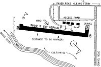
| A110-1 | RWY 08 +150' PLINE CROSSES SNAKE RIVER CANYON APPROX 5 MILES DOWNRIVER. |
| A110-2 | RY 08/26 DISTANCE TO GO MARKERS EVERY 1000 FT S SIDE OF RY. |
| A110-3 | FOR CD CTC MUO RAPCON AT 208-828-6096 WHEN OPN. SALT LAKE ARTCC AT 801-320-2568 WHEN CLSD. |
| A58-08 | +4' FENCE AT 95' ON CNTRLN. |
| A58-26 | +4 FT FENCE AT 75 FT ON CNTRLN; +15 FT ROAD AT 85 FT ON CNTRLN. |
| A81-APT | ACTVT MIRL RY 08/26 - CTAF. |
| A81-BCN | ACTIVATE BEACON-CTAF, |
| A84 | NON-STD PAINTED TIRES. |
| E111 | BUILT PRIOR TO 1959. |
Runways
Runway Summary
| Runways: | 08/26 |
| Longest Runway: | 08/26 is 3050 ft (930 m) long |
| Runways with an Instrument Approach: |
U89 Airport Runway Details
| Runway 08/26 | 3050 ft x 60 ft (930 m x 18 m) | |
| Surface: | Asphalt - Fair condition - No special surface treatment | |
| Runway Edge Lights: | Medium Intensity | |
Runway 08 |
Runway 26 |
|
Latitude: |
42-56-38.6000N | 42-56-35.7500N |
Longitude: |
115-20-08.7400W | 115-19-27.9000W |
Glide Path Angle: |
0.0 degrees | 0.0 degrees |
Traffic Pattern: |
Left | Left |
Runway Markings Type: |
Basic | Basic |
Runway Markings Condition: |
Good | Good |
Object at End: |
TREES | |
Object Height: |
80 | |
Distance from End: |
1250 | |
Object Centerline Offset: |
0 ft. left and right of centerline |
Services
Airframe Repair: |
Major |
Powerplant Repair: |
Major |
Bottled Oxygen: |
None |
Fuel Available: |
100LL, Jet A |
Landing Fees: |
No |
Parking: |
Tiedowns available |
Maps & Diagrams
U89 Sectional
Flight Planning
at skyvector.com
at skyvector.com