Location
Latitude: |
31-51-36.0000N (31.86) |
Longitude: |
086-00-50.0000W (-86.013889) |
Elevation: |
397.2 feet MSL (121 m MSL) |
Magnetic Variation: |
4.2 W (as of April 2024 from WMM2020 model) |
Time Zone: |
UTC -6.0 (Standard Time) UTC -5.0 (Daylight Savings Time) |
From City: |
04 N.M. NW of Troy, Alabama |
Found On: |
New Orleans Chart |
FAA Region: |
ASO |
Contacts
Manager: |
Publicly owned: |
| TRENT CRAWFORD 301 CAMPBELL FIELD ROAD TROY, AL 36079 334-566-3470 |
CITY OF TROY PO BOX 549 TROY, AL 36081 334-566-0177 |
Operations
Airport Status: |
Operational |
Facility Use: |
Public |
Type: |
Airport |
Activation Date: |
12/1944 |
Control tower: |
Yes |
Attendance (Months/Days/Hours): |
Months/Days/Hours ALL/ALL/0800-1700 |
Boundary ARTCC: |
ZTL (Atlanta) |
Responsible ARTCC: |
ZJX (Jacksonville) |
Lighting Schedule: |
SEE RMK |
Segmented Circle Indicator: |
No |
Traffic Pattern Altitude (MSL): |
1397 feet (426 m) |
NOTAMs Facility: |
TOI |
NOTAM-D Service: |
Yes |
International Airport of Entry: |
No |
Customs Landing Rights: |
No |
Military Landing Rights: |
Yes |
Civil/Military Joint Use: |
No |
Based Aircraft
| Single Engine: | 23 |
| Multi Engine: | 7 |
| Jet Engine: | 2 |
Annual Operations (as of 08/31/2020)
| Total Operations: | 69088 | |
| GA Local: | 8928 | 12.9% |
| GA Itinerant: | 32000 | 46.3% |
| Military Aircraft: | 28160 | 40.8% |
Communications
| CTAF: | 124.300 |
| Unicom: | 122.800 |
| Tower: | TROY 124.3 306.9 Hrs: 1400-2200Z++ MON-FRI EXCP HOLS. |
| Ground: | 121.9 294.7 |
| Approach: | CAIRNS 121.1 121.1 ATLANTA ARTCC |
| Departure: | CAIRNS 121.1 121.1 ATLANTA ARTCC |
| ATIS: | 120.925 Hrs: 24 |
| ASOS: | (334-566-3081) |
| EMERG: | 121.5 |
| EMERG: | 243.0 |
- APCH/DEP SVC PRVDD BY ATLANTA ARTCC ON FREQS 120.55/270.25 (MONTGOMERY RCAG) WHEN CAIRNS APCH/DEP CLSD.
- OPERATES NON-CONTINOUSLY.
Fixed Based Operators (FBOs) & Fuel
(Click on a business for detail)
Please help us keep this information up to date. This is a FREE SERVICE just like everything else on Airport Guide! If you see that a business needs to be added, modified, or deleted please fill out our Update Form.
To add, modify, or delete a business click here.
Please help us keep this information up to date. This is a FREE SERVICE just like everything else on Airport Guide! If you see that a business needs to be added, modified, or deleted please fill out our Update Form.
Area Code: 334 |
| Business Name | Frequency | Phone | Fuel Grade |
|---|
Flight Service Stations
| Primary | Alternate | |
| FSS on Field: | N | |
| FSS Name (ID): | Anniston(ANB) | |
| Frequency: | ||
| Toll Free Phone: | 1-800-WX-BRIEF |
Instrument Procedures / Charts
FAA Terminal Procedures valid from 0901Z 03/21/24 to 0901Z 04/18/24.
There are various types of charts available for an airport. They are listed in the Page Type column. Here is a legend for those types:
APD - Airport Diagram
DP - Departure Procedure Charts
HOT - Hot Spots
IAP - Instrument Approach Procedure Charts
MIN - Minimums
STAR - Standard Terminal Arrival Charts
| Page Type | Page Name | Volume | Action Since Last Cycle |
|---|---|---|---|
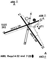
| APD | AIRPORT DIAGRAM | SE-4 | Added |
| IAP | ILS OR LOC RWY 07 | SE-4 | Changed |
| IAP | NDB RWY 07 | SE-4 | Changed |
| IAP | RNAV (GPS) RWY 07 | SE-4 | Changed |
| IAP | RNAV (GPS) RWY 14 | SE-4 | Changed |
| IAP | RNAV (GPS) RWY 25 | SE-4 | Changed |
| IAP | RNAV (GPS) RWY 32 | SE-4 | Changed |
| MIN | ALTERNATE MINIMUMS | SE-4 | |
| MIN | RADAR MINIMUMS | SE-4 | |
| MIN | TAKEOFF MINIMUMS | SE-4 |
Terminal Procedures are only available for airports in several countries with more being added all the time. If you are looking for a specific country's charts, please send an email to support(at)airportguide.com stating the country name. This will be used to prioritize the implementation.
Navigation Aids (Navaids) near TOI
| Dist (NM) | ID | Morse Code | Name | Type | Freq | True Hdg | Mag Hdg |
|---|---|---|---|---|---|---|---|
| 5.0 | TOI | _ _ _ _ . . | Blood | NDB | 365 | 249 | 253 |
| 26.7 | MGM | _ _ _ _ . _ _ | Montgomery | VORTAC | 112.10 | 324 | 328 |
| 31.3 | BVG | _ . . . . . . _ _ _ . | Boll Weevil | NDB | 352 | 176 | 180 |
| 32.9 | LOR | . _ . . _ _ _ . _ . | Lowe | NDB | 269 | 155 | 159 |
| 34.3 | EDN | . _ . . _ . | Enterprise | VOR | 116.60 | 170 | 174 |
| 34.4 | HYE | . . . . _ . _ _ . | Hanchey | NDB | 221 | 147 | 151 |
| 34.5 | HEY | . . . . . _ . _ _ | Hanchey | VOR | 110.60 | 147 | 151 |
| 36.0 | MXF | _ _ _ . . _ . . _ . | Maxwell | TACAN | 115.00 | 330 | 334 |
| 37.0 | MG | _ _ _ _ . | Marra | NDB | 245 | 317 | 321 |
| 38.4 | OZR | _ _ _ _ _ . . . _ . | Cairns | VOR-DME | 111.20 | 157 | 161 |
| 38.5 | JUY | . _ _ _ . . _ _ . _ _ | Judd | NDB | 264 | 210 | 214 |
| 39.4 | OZ | _ _ _ _ _ . . | Brynt | NDB | 212 | 165 | 169 |
| 41.4 | TGE | _ _ _ . . | Tuskegee | VOR-DME | 117.30 | 24 | 28 |
| 45.3 | EUF | . . . _ . . _ . | Eufaula | VORTAC | 109.20 | 82 | 87 |
| 45.6 | RRS | . _ . . _ . . . . | Wiregrass | VORTAC | 111.60 | 139 | 143 |
| 52.6 | SE | . . . . | Pollk | NDB | 344 | 298 | 302 |
| 56.7 | AWS | . _ . _ _ . . . | Lawson | NDB | 335 | 62 | 67 |
| 57.6 | JYU | . _ _ _ _ . _ _ . . _ | Junior | VOR-DME | 113.60 | 300 | 304 |
| 59.1 | LSF | . _ . . . . . . . _ . | Lawson | VOR-DME | 111.40 | 61 | 66 |
| 60.8 | CS | _ . _ . . . . | Fenix | NDB | 355 | 54 | 59 |
Nearby Airports with Fuel
Notices to Airmen (NOTAMS)
Remarks
| A110-1 | EXTSV HEL AND FLT TRNG OPS INVOF ARPT 0630-1700 MON-FRI EXCP HOL. |
| A110-2 | NO RUNNING LNDGS ON RWY OR TWY BY SKID-EQUIPPED HEL. |
| A110-5 | CTC CAIRNS AAF FOR FCST 0600Z++ MON-0700Z++ SAT, EXC HOL. WX OBSN VIS RSTD NE-E DUE TO HGR. REMOTE BRIEFING SVC AVBL 26 OWS, BARKSDALE AFB, DSN 331-2651, C866-223-9328 (TOLL FREE) OR HTTPS://OWS.BARKSDALE.AF.MIL. |
| A110-6 | NO ARR/DEP TO/FROM N HELI OVR FBO RAMP. |
| A110-7 | FOR CD WHEN ATCT CLSD CTC CAIRNS APCH AT 334-255-8402; FOR CD WHEN CAIRNS APCH CLSD CTC ATLANTA ARTCC AT 770-210-7692. |
| A17 | PPR FOR NIGHT CANCELLED |
| A32-14/32 | 25 FT PAVED SHOULDERS. |
| A33-14/32 | WIDESPREAD BLOCK CRACKING, RAVELING, AND VEGETATION. |
| A40-14/32 | MIRL LCTD 35 FT FM RWY EDGE; THLD LGTS LCTD 17 FT FM RWY 32 END. |
| A42-07 | MARKINGS FADED. |
| A42-25 | MARKINGS FADED. |
| A70-FUEL-10 | 0LL FUEL AVBL 0800-1700 MON-SUN; AFTER HRS CALL 334-566-3470. CONTRACT MILITARY FUEL. |
| A81-APT | ACTVT PAPI RWY 07; MIRL RWY 07/25, 14/32 - CTAF. |
Runways
Runway Summary
| Runways: | 07/25 14/32 |
| Longest Runway: | 07/25 is 6197 ft (1889 m) long |
| Runways with an Instrument Approach: | 07 |
TOI Airport Runway Details
| Runway 07/25 | 6197 ft x 100 ft (1889 m x 30 m) | |
| Runway Length Source: | 3RD PARTY SURVEY as of 05/16/2014 | |
| Surface: | Asphalt - Excellent condition - No special surface treatment | |
| Runway Edge Lights: | Medium Intensity | |
Runway Weight Bearing Capacity (in thousands of pounds) |
||
| Single Wheel Landing Gear: | 24.0 | |
| Dual Wheel Landing Gear: | 80.0 | |
| Dual Tandem Wheel Landing Gear: | 140.0 | |
Runway 07 |
Runway 25 |
|
Elevation: |
380.7 | 393.6 |
Latitude: |
31-51-26.3160N | 31-51-47.7738N |
Longitude: |
086-01-35.1277W | 086-00-27.8200W |
|
Runway True Alignment: |
069 | 250 |
ILS Type: |
ILS/DME | |
Glide Path Angle: |
3.0 degrees | 0.0 degrees |
Traffic Pattern: |
Left | Left |
Runway Markings Type: |
Nonprecision Instrument | Precision Instrument |
Runway Markings Condition: |
Good | Good |
Object at End: |
TREE | TREES |
Object Height: |
64 | 41 |
Distance from End: |
2009 | 821 |
Object Centerline Offset: |
287 ft. left of centerline | 299 ft. left of centerline |
Visual Glide Slope Indicators: |
4-Light PAPI On Left Side Of Runway | |
Threshold Crossing Height: |
44 |
| Runway 14/32 | 5024 ft x 100 ft (1531 m x 30 m) | |
| Runway Length Source: | 3RD PARTY SURVEY as of 05/16/2014 | |
| Surface: | Asphalt - Excellent condition - No special surface treatment | |
| Runway Edge Lights: | Medium Intensity | |
Runway Weight Bearing Capacity (in thousands of pounds) |
||
| Single Wheel Landing Gear: | 24.0 | |
| Dual Wheel Landing Gear: | 80.0 | |
| Dual Tandem Wheel Landing Gear: | 140.0 | |
Runway 14 |
Runway 32 |
|
Elevation: |
397.2 | 365.1 |
Latitude: |
31-51-54.6337N | 31-51-14.9719N |
Longitude: |
086-00-53.4527W | 086-00-18.3291W |
|
Runway True Alignment: |
143 | 323 |
Glide Path Angle: |
0.0 degrees | 0.0 degrees |
Traffic Pattern: |
Left | Left |
Runway Markings Type: |
Nonprecision Instrument | Nonprecision Instrument |
Runway Markings Condition: |
Good | Good |
Object at End: |
TREE | TREES |
Object Height: |
86 | 70 |
Distance from End: |
947 | 1166 |
Object Centerline Offset: |
287 ft. left of centerline | 299 ft. left of centerline |
Services
Airframe Repair: |
Major |
Powerplant Repair: |
Major |
Bottled Oxygen: |
High Pressure |
Bulk Oxygen: |
High Pressure |
Fuel Available: |
100LL, Jet A, Jet A-1+ |
Landing Fees: |
No |
Parking: |
Tiedowns available |
Maps & Diagrams
TOI Sectional
Flight Planning
at skyvector.com
at skyvector.com