Location
Latitude: |
40-09-01.1000N (40.150306) |
Longitude: |
122-15-07.9000W (-122.252194) |
Elevation: |
352.3 feet MSL (107 m MSL) |
Magnetic Variation: |
13.5 E (as of April 2024 from WMM2020 model) |
Time Zone: |
UTC -8.0 (Standard Time) UTC -7.0 (Daylight Savings Time) |
From City: |
02 N.M. S of Red Bluff, California |
Found On: |
Klamath Falls Chart |
FAA Region: |
AWP |
Contacts
Manager: |
Publicly owned: |
| R. SCOTT MILLER 555 WASHINGTON ST RED BLUFF, CA 96080 530-527-2605 |
CITY OF RED BLUFF 555 WASHINGTON ST RED BLUFF, CA 96080 530-527-2605 |
Operations
Airport Status: |
Operational |
Facility Use: |
Public |
Type: |
Airport |
Activation Date: |
04/1948 |
Control tower: |
No |
Attendance (Months/Days/Hours): |
Months/Days/Hours ALL/ALL/0700-DUSK |
Boundary ARTCC: |
ZOA (Oakland) |
Responsible ARTCC: |
ZOA (Oakland) |
Lighting Schedule: |
SEE RMK |
Segmented Circle Indicator: |
Yes |
Traffic Pattern Altitude (MSL): |
1352 feet (412 m) |
NOTAMs Facility: |
RBL |
NOTAM-D Service: |
Yes |
International Airport of Entry: |
No |
Customs Landing Rights: |
No |
Military Landing Rights: |
Yes |
Civil/Military Joint Use: |
No |
Based Aircraft
| Single Engine: | 69 |
| Multi Engine: | 2 |
| Jet Engine: | 1 |
| GA Helicopters: | 11 |
| Gliders: | 1 |
| Ultralights: | 3 |
Annual Operations (as of 12/31/2022)
| Total Operations: | 26150 | |
| Air Taxi: | 1000 | 3.8% |
| GA Local: | 10000 | 38.2% |
| GA Itinerant: | 15000 | 57.4% |
| Military Aircraft: | 150 | 0.6% |
Communications
| CTAF: | 123.000 |
| Unicom: | 123.000 |
| ASOS: | 120.775 (530-528-8030) |
- APCH/DEP CTL SVC PRVDD BY OAKLAND ARTCC (ZOA) ON FREQS 132.2/350.3 (RED BLUFF RCAG).
Fixed Based Operators (FBOs) & Fuel
(Click on a business for detail)
Please help us keep this information up to date. This is a FREE SERVICE just like everything else on Airport Guide! If you see that a business needs to be added, modified, or deleted please fill out our Update Form.
To add, modify, or delete a business click here.
Please help us keep this information up to date. This is a FREE SERVICE just like everything else on Airport Guide! If you see that a business needs to be added, modified, or deleted please fill out our Update Form.
Area Code: 530 |
| Business Name | Frequency | Phone | Fuel Grade |
|---|---|---|---|
| Aircraft Inspection Service and Sales
Update FBO info |
Unicom 123.6 | 527-7742 | |
| Cardan Aircraft Painting
Update FBO info |
527-6547 | ||
| DMK Aviation
Update FBO info |
529-3240 | ||
| DZ, Inc.
Update FBO info |
527-2560 | 80, 100LL | |
| The Hangar
Update FBO info |
527-7742 |
Flight Service Stations
| Primary | Alternate | |
| FSS on Field: | N | |
| FSS Name (ID): | Rancho Murieta(RIU) | |
| Frequency: | ||
| Toll Free Phone: | 1-800-WX-BRIEF |
Instrument Procedures / Charts
FAA Terminal Procedures valid from 0901Z 03/21/24 to 0901Z 04/18/24.
There are various types of charts available for an airport. They are listed in the Page Type column. Here is a legend for those types:
APD - Airport Diagram
DP - Departure Procedure Charts
HOT - Hot Spots
IAP - Instrument Approach Procedure Charts
MIN - Minimums
STAR - Standard Terminal Arrival Charts
| Page Type | Page Name | Volume | Action Since Last Cycle |
|---|---|---|---|
| IAP | RNAV (GPS) RWY 15 | SW-2 | |
| IAP | RNAV (GPS) RWY 33 | SW-2 | |
| IAP | VOR RWY 33 | SW-2 | |
| IAP | VOR/DME RWY 15 | SW-2 | |
| MIN | ALTERNATE MINIMUMS | SW-2 | |
| MIN | TAKEOFF MINIMUMS | SW-2 |
Terminal Procedures are only available for airports in several countries with more being added all the time. If you are looking for a specific country's charts, please send an email to support(at)airportguide.com stating the country name. This will be used to prioritize the implementation.
Navigation Aids (Navaids) near RBL
| Dist (NM) | ID | Morse Code | Name | Type | Freq | True Hdg | Mag Hdg |
|---|---|---|---|---|---|---|---|
| 2.3 | PBT | . _ _ . _ . . . _ | Proberta | NDB | 338 | 162 | 149 |
| 3.2 | RBL | . _ . _ . . . . _ . . | Red Bluff | VORTAC | 115.70 | 166 | 153 |
| 21.3 | RDD | . _ . _ . . _ . . | Redding | VOR-DME | 114.35 | 355 | 341 |
| 28.5 | CIC | _ . _ . . . _ . _ . | Chico | VOR-DME | 109.80 | 139 | 126 |
| 50.0 | MXW | _ _ _ . . _ . _ _ | Maxwell | VORTAC | 110.00 | 178 | 165 |
| 65.6 | ILA | . . . _ . . . _ | Williams | VORTAC | 114.40 | 170 | 157 |
| 65.9 | MY | _ _ _ . _ _ | Halow | NDB | 222 | 153 | 140 |
| 69.5 | UK | . . _ _ . _ | Kearn | NDB | 371 | 221 | 208 |
| 70.5 | MYV | _ _ _ . _ _ . . . _ | Marysville | VOR-DME | 110.80 | 153 | 140 |
| 71.5 | BAB | _ . . . . _ _ . . . | Beale | TACAN | 108.60 | 148 | 135 |
| 81.0 | ENI | . _ . . . | Mendocino | VORTAC | 112.30 | 215 | 202 |
| 81.9 | FJS | . . _ . . _ _ _ . . . | Fort Jones | VOR-DME | 116.25 | 342 | 328 |
| 92.8 | SMF | . . . _ _ . . _ . | Sacramento Intl | VOT | 111.40 | 160 | 147 |
| 95.2 | MOG | _ _ _ _ _ _ _ . | Montague | NDB | 404 | 353 | 339 |
| 95.8 | FOT | . . _ . _ _ _ _ | Fortuna | VORTAC | 114.00 | 289 | 275 |
| 96.5 | AHC | . _ . . . . _ . _ . | Amedee | VOR-DME | 109.00 | 85 | 72 |
| 97.3 | MCC | _ _ _ . _ . _ . _ . | Mc Clellan | VOR-DME | 109.20 | 155 | 142 |
| 98.2 | ACV | . _ _ . _ . . . . _ | Arcata | VOR-DME | 115.05 | 301 | 287 |
Nearby Airports with Fuel
Notices to Airmen (NOTAMS)
Remarks
| A110-2 | TWYS HAVE HWY TYPE EDGE REFLECTORS. |
| A110-5 | ULTRALIGHT ACT ON AND INVOF ARPT. |
| A110-6 | RWY 15 CALM WIND RWY. |
| A110-7 | FOR CD IF UNA TO CTC ON FSS FREQ, CTC OAKLAND ARTCC AT 510-745-3380. |
| A70-FUEL-10 | 0LL AUTOMATED CREDIT CARD FUEL SYSTEM 24 HRS. |
| A81-APT | ACTVT REIL RWY 15 & 33; PAPI RWY 15 & VASI RWY 33; MIRL RWY 15/33 - CTAF. |
| E147 | TPA: 1500 AGL TBJT OPS; 1000 AGL ALL OTHERS. |
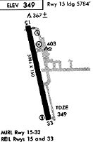
Runways
Runway Summary
| Runways: | 15/33 |
| Longest Runway: | 15/33 is 5431 ft (1655 m) long |
| Runways with an Instrument Approach: |
RBL Airport Runway Details
| Runway 15/33 | 5431 ft x 100 ft (1655 m x 30 m) | |
| Runway Length Source: | 3RD PARTY SURVEY as of 10/09/2010 | |
| Surface: | Asphalt - Excellent condition - No special surface treatment | |
| Runway Edge Lights: | Medium Intensity | |
Runway Weight Bearing Capacity (in thousands of pounds) |
||
| Single Wheel Landing Gear: | 30.0 | |
| Dual Wheel Landing Gear: | 65.0 | |
Runway 15 |
Runway 33 |
|
Elevation: |
347.2 | 343.8 |
Latitude: |
40-09-27.3864N | 40-08-34.8686N |
Longitude: |
122-15-15.1149W | 122-15-00.7173W |
|
Runway True Alignment: |
168 | 348 |
Glide Path Angle: |
3.0 degrees | 3.0 degrees |
Traffic Pattern: |
Right | Left |
Runway Markings Type: |
Nonprecision Instrument | Nonprecision Instrument |
Runway Markings Condition: |
Good | Good |
Visual Glide Slope Indicators: |
2-Light PAPI On Left Side Of Runway | 4-Box VASI On Left Side Of Runway |
REIL: |
Yes | Yes |
Touchdown Lights: |
No | No |
Centerline Lights: |
No | No |
Threshold Crossing Height: |
40 | 40 |
Services
Airframe Repair: |
Major |
Powerplant Repair: |
Major |
Bottled Oxygen: |
None |
Bulk Oxygen: |
High Pressure |
Fuel Available: |
100LL, Jet A |
Landing Fees: |
Yes |
Parking: |
Tiedowns available |
Maps & Diagrams
RBL Sectional
Flight Planning
at skyvector.com
at skyvector.com