Location
Latitude: |
42-06-51.4060N (42.114279) |
Longitude: |
087-54-05.5470W (-87.901541) |
Elevation: |
647.0 feet MSL (197 m MSL) |
Magnetic Variation: |
4 W (as of April 2024 from WMM2020 model) |
Time Zone: |
UTC -6.0 (Standard Time) UTC -5.0 (Daylight Savings Time) |
From City: |
18 N.M. NW of Chicago/Prospect Heights/Wheeling, Illinois |
Found On: |
Chicago Chart |
FAA Region: |
AGL |
Contacts
Manager: |
Publicly owned: |
| JEFF MILLER 1020 S. PLANT ROAD WHEELING, IL 60090 847-537-2580 |
CITIES OF WHEELING & PROSPECT HGTS 1020 S. PLANT ROAD WHEELING, IL 60090 847-537-2580 |
Operations
Airport Status: |
Operational |
Facility Use: |
Public |
Type: |
Airport |
Activation Date: |
02/1944 |
Control tower: |
Yes |
Attendance (Months/Days/Hours): |
Months/Days/Hours ALL/ALL/ALL |
Boundary ARTCC: |
ZAU (Chicago) |
Responsible ARTCC: |
ZAU (Chicago) |
Lighting Schedule: |
SEE RMK |
Segmented Circle Indicator: |
Yes |
Traffic Pattern Altitude (MSL): |
1647 feet (502 m) |
NOTAMs Facility: |
PWK |
NOTAM-D Service: |
Yes |
International Airport of Entry: |
No |
Customs Landing Rights: |
No |
Military Landing Rights: |
Yes |
Civil/Military Joint Use: |
No |
Based Aircraft
| Single Engine: | 128 |
| Multi Engine: | 18 |
| Jet Engine: | 86 |
| GA Helicopters: | 4 |
Annual Operations (as of 07/31/2023)
| Total Operations: | 66266 | |
| Commercial: | 20 | 0.0% |
| Air Taxi: | 18805 | 28.4% |
| GA Local: | 47437 | 71.6% |
| Military Aircraft: | 4 | 0.0% |
Communications
| CTAF: | 119.900 |
| Unicom: | 122.950 |
| Tower: | EXECUTIVE 119.9 Hrs: 0600-2200 MON-FRI & 0700-2200 SAT-SUN |
| Clearance Del.: | 124.7 |
| Ground: | 121.7 |
| Approach: | CHICAGO 120.55 120.55 120.55 120.55 |
| Departure: | CHICAGO 120.55 120.55 120.55 120.55 |
| ATIS: | 124.2 Hrs: 24 |
| ASOS: | (847-465-0291) |
Fixed Based Operators (FBOs) & Fuel
(Click on a business for detail)
Please help us keep this information up to date. This is a FREE SERVICE just like everything else on Airport Guide! If you see that a business needs to be added, modified, or deleted please fill out our Update Form.
To add, modify, or delete a business click here.
Please help us keep this information up to date. This is a FREE SERVICE just like everything else on Airport Guide! If you see that a business needs to be added, modified, or deleted please fill out our Update Form.
Area Code: 847 |
| Business Name | Frequency | Phone | Fuel Grade |
|---|---|---|---|
| Aircraft Propeller Service, Inc.
Update FBO info |
800-323-4130, 541-1133 | ||
| Airway Flight Services
Website Update FBO info |
215-0098 | ||
| American Flyers
Website Update FBO info |
800-722-0808, 537-3050 | ||
| Jim's Pilot and Gift Shop
Update FBO info |
215-8282 | ||
| North American Jet, Inc.
Update FBO info |
808-0812 | 100LL, Jet A | |
| Page Engelke & Assoc., Inc.
Update FBO info |
459-0360 | ||
| Priester Aviation
Website Update FBO info |
Unicom 122.95 | 800-323-7887, 537-1200 | 100LL, Jet A |
| Procopter International
Update FBO info |
465-9111, 665-9119 | ||
| Service Aviation
Update FBO info |
Arinc 130.77 | 888-795-3261 | Jet A |

|
 Avfuel |
Jet A - 2.49 USD per gallon on 9/2/01 |
Trucks 5 cents/100 gallon discount ex. 200-299 gallons = $2.39 400-499 gallons = $2.29 |
| Signature Flight Support
Update FBO info |
Unicom: 122.95, Arinc: 129.95 | +1 847 537 1200 | |
| Windy City Charter
Website Update FBO info |
808-9868 | ||
| Windy City Flyers
Website Update FBO info |
808-1188 |
Flight Service Stations
| Primary | Alternate | |
| FSS on Field: | N | |
| FSS Name (ID): | Kankakee(IKK) | |
| Frequency: | ||
| Toll Free Phone: | 1-800-WX-BRIEF |
Instrument Procedures / Charts
FAA Terminal Procedures valid from 0901Z 03/21/24 to 0901Z 04/18/24.
There are various types of charts available for an airport. They are listed in the Page Type column. Here is a legend for those types:
APD - Airport Diagram
DP - Departure Procedure Charts
HOT - Hot Spots
IAP - Instrument Approach Procedure Charts
MIN - Minimums
STAR - Standard Terminal Arrival Charts
| Page Type | Page Name | Volume | Action Since Last Cycle |
|---|---|---|---|
| APD | AIRPORT DIAGRAM | EC-3 | Changed |
| DP | JORJO FIVE (RNAV) | EC-3 | |
| DP | MONKZ FIVE (RNAV) | EC-3 | |
| DP | MONKZ FIVE (RNAV)[DELIMITER] CONT.1 | EC-3 | |
| DP | PAL-WAUKEE SIX | EC-3 | |
| HOT | HOT SPOT | EC-3 | |
| IAP | ILS OR LOC RWY 16 | EC-3 | |
| IAP | RNAV (GPS) RWY 16 | EC-3 | |
| IAP | RNAV (GPS) RWY 30 | EC-3 | |
| IAP | VOR RWY 16 | EC-3 | |
| LAH | LAHSO | EC-3 | |
| MIN | ALTERNATE MINIMUMS | EC-3 | |
| MIN | TAKEOFF MINIMUMS | EC-3 | |
| STAR | GOPAC THREE (RNAV) | EC-3 |
Terminal Procedures are only available for airports in several countries with more being added all the time. If you are looking for a specific country's charts, please send an email to support(at)airportguide.com stating the country name. This will be used to prioritize the implementation.
Navigation Aids (Navaids) near PWK
| Dist (NM) | ID | Morse Code | Name | Type | Freq | True Hdg | Mag Hdg |
|---|---|---|---|---|---|---|---|
| 6.8 | OBK | _ _ _ _ . . . _ . _ | Northbrook | VOR-DME | 113.00 | 340 | 344 |
| 7.2 | GCO | _ _ . _ . _ . _ _ _ | Chicago | DME | 108.25 | 180 | 184 |
| 7.6 | ORD | _ _ _ . _ . _ . . | Chicago O'hare | VOR-DME | 113.90 | 181 | 185 |
| 10.4 | ME | _ _ . | Deana | NDB | 350 | 212 | 216 |
| 20.8 | MDW | _ _ _ . . . _ _ | Chicago Midway | VOT | 111.00 | 161 | 165 |
| 21.4 | UG | . . _ _ _ . | Wauke | NDB | 379 | 11 | 15 |
| 23.9 | HK | . . . . _ . _ | Ermin | NDB | 332 | 172 | 176 |
| 24.1 | DPA | _ . . . _ _ . . _ | Dupage | VOR-DME | 108.40 | 236 | 240 |
| 24.3 | MX | _ _ _ . . _ | Kedzi | NDB | 248 | 157 | 161 |
| 27.4 | EN | . _ . | Codee | NDB | 389 | 348 | 352 |
| 29.1 | ENW | . _ . . _ _ | Kenosha | DME | 109.2 | 357 | 361 |
| 34.1 | RA | . _ . . _ | Paser | NDB | 206 | 0 | 4 |
| 38.8 | BUU | _ . . . . . _ . . _ | Burbun | DME | 114.5 | 332 | 336 |
| 38.8 | JOT | . _ _ _ _ _ _ _ | Joliet | VOR-DME | 112.30 | 208 | 212 |
| 39.1 | HRK | . . . . . _ . _ . _ | Horlick | DME | 114.05 | 5 | 9 |
| 39.1 | CGT | _ . _ . _ _ . _ | Chicago Heights | VORTAC | 114.20 | 157 | 161 |
| 46.6 | LVV | . _ . . . . . _ . . . _ | Lake Lawn | NDB | 404 | 319 | 323 |
| 48.1 | GM | _ _ . _ _ | Teels | NDB | 242 | 352 | 356 |
| 50.0 | MKE | _ _ _ . _ . | Milwaukee | VOT | 109.00 | 0 | 4 |
| 50.9 | EON | . _ _ _ _ . | Peotone | VORTAC | 113.20 | 174 | 178 |
Nearby Airports with Fuel
Notices to Airmen (NOTAMS)
Remarks
| A110-11 | NOISE SENSITIVE AREA N AND S OF ARPT. |
| A110-14 | CONDS NOT RPRTD; SUN 1530L-0630L ON MON, MON FM 2100L-0630L, TUES FM 1530L-0630L ON WED, WED FM 1530L-0630L ON THURS, THURS FROM 2100L-0630L ON FRI, FRI FM 2100L-0630L ON SAT, SAT 1530L-0630L ON SUN. |
| A110-19 | NOISE ABATEMENT PROCS: RWY 34 HOLD PAD PREFERRED RUN UP AREA FOR TURBINE ACFT; ALIGN ACFT AT 190 DEG WHILE WAITING TKOF OR RUN UPS. RWY 16 HOLD PAD; ALIGN ACFT AT 315 DEG. |
| A110-23 | NO EDGE LGTS ON TWY F, P, Q, T - REFLECTORS ONLY. |
| A110-24 | AREA 2 AND 3 PERMITTED TENANT PRKG ONLY. |
| A110-25 | ACFT TRANSVERSING NE HNGRS; ENTER ON QUEBEC EXIT ON PAPA. |
| A110-26 | RWY GUARD LGTS NOT AVBL AT ALL RWY AND TWY INTS. |
| A110-27 | NMRS CRANES INVOF ARPT. |
| A110-28 | FOR CD WHEN ATCT CLSD, AND IF UNA ON FREQ, CTC CHICAGO APCH AT 847-289-0926. |
| A110-29 | PREF MAINTENANCE RUN UP AREA: TXY C ABM THE TWR; EXHAUST FACING TWD CNTR OF ARPT. RWY 34 HOLD PAD: ALIGN ACFT AT 190 DEG WHILE WAITING TKOF OR RUN UPS. MAINTENANCE RUNS AT THE 16 HOLD PAD PROHIBITIED. NO TURBINE ENG RUNS BTWN 2200L AND 0700L ALL WEEK. RADIO CTC REQUIRED WITH TOWER AT ALL TIMES. |
| A110-30 | TAXILANE P; TWR VIEW PRLY OBSTD BY HNGRS & TREES. TAXILANE Q AND NE HNGRS; TWR VIEW PRLY OBSTD BY BLDGS & TREES. TWY T AND SW HNGRS; TWR VIEW PRLY OBSTD BY HNGRS. |
| A110-31 | TWY F CLSD TO ACFT WINGSPAN MORE THAN 40 FT. |
| A110-32 | TWY B BTN APCH END RWY 24 AND AREA 2 RAMP CLSD TO ACFT WINGSPAN MORE THAN 40 FT. |
| A110-33 | ALL TRAN ACFT CLRG CUSTOMS MUST UTILIZE FBO AFT CLRD. U.S. CBP USER FEES BILLED BY FBOS ONLY. |
| A110-34 | RWY 12/30 PREFERRED FOR OPS BTN 2200L AND 0700L FOR NOISE ABATEMENT PURPOSES. |
| A110-35 | PWK ARRIVAL ALERT NOTICE PUBLISHED FOR LANDING NORTHWEST RWY 34 AND RWY 30. VISIT FAA.GOV/AIRPORTS/RUNWAY_SAFETY/HOTSPOTS/AAN/PWK-ARRIVAL-ALERT-NOTICE.PDF |
| A110-4 | BIRDS & WILDLIFE ON AND INVOF ARPT. PYROTECHNICS, WILDLIFE LASER BIRD CTL IN USE. |
| A110-36 | (CONTACT ADDRESS LINE 1) EMAIL ADDRESS: OPS@CHIEXEC.COM |
| A110-37 | (CONTACT NAME) MON-FRI 0700-1530L |
| A110-38 | (CONTACT PHONE NR) EXT 119 & EXT 114. |
| A23-34 | WHEN CIRCLING E OF THE ARPT FOR RIGHT TFC RWY 34, ACFT HAVE OFTEN MISALIGNED WITH RWY 30. EXER VIGILANCE AND VFY RWY ALNMT. |
| A43-16 | PAPI UNUSBL BYD 8 DEG LEFT & 9 DEG RIGHT OF CNTRLN. |
| A43-34 | PAPI UNUSBL BYD 8 DEG LEFT & RIGHT OF CNTRLN. |
| A49-16 | NSTD SPACING. |
| A57-06 | APCH RATIO 22:1 AT DSPLCD THR. |
| A57-12 | APCH RATIO IS 20:1 AT DSPLCD THR. |
| A57-16 | CONTROLLING OBSTN EXCEEDS A 45 DEG SLP. |
| A57-24 | APCH RATIO 20:1 AT DSPLCD THR. |
| A57-30 | APCH RATIO IS 21:1 AT DSPLCD THR. |
| A58-12 | 15 FT ROAD & 6 FT FENCE. |
| A58-24 | 14 FT ROAD & +40 FT TREES 150 FT & 50 FT L; 6 FT FENCE. |
| A58-30 | +6 FT FENCE 0 FT FM THR; +20 FT TREES 0 FT & 50 FT FM THR; 15 FT ROAD. |
| A81-APT | ACTVT REIL RWY 16 & 34; RLLS LGTS RWY 16; HIRL RWY 06/24; 16/34; MIRL RWY 12/30 - CTAF. |
| E111 | ARPT ESTD PRIOR TO 1959. NO OBJECTION FOR ASP ON RWYS 12L/30R & 16/34 ONLY. |
| E60-16 | ENGINEERED MATERIALS ARRESTING SYSTEM (EMAS) RY 16 DEP END: 242.97 FT IN LENGTH BY 170.10 FT IN WIDTH, SETBACK 35 FT FROM RY END. |
| E60-34 | ENGINEERED MATERIALS ARRESTING SYSTEM (EMAS) RY 34 DEP END: 230.82 FT IN LENGTH BY 170.10 FT IN WIDTH, SETBACK 304.18 FT FROM RY END. |
| E80 | US CUSTOMS USER FEE ARPT. |
| E80A | US CUST USER FEE ARPT. FOR CUST CLNC 2 HR MIN ADVN NOTICE RQRD MON-FRI 1100-1900. CTC CUST AT 847-894-7292. |
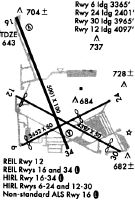
Runways
Runway Summary
| Runways: | 06/24 12/30 16/34 |
| Longest Runway: | 16/34 is 5001 ft (1524 m) long |
| Runways with an Instrument Approach: | 16 |
PWK Airport Runway Details
| Runway 06/24 | 3677 ft x 50 ft (1121 m x 15 m) | |
| Runway Length Source: | 3RD PARTY SURVEY as of 10/12/2018 | |
| Surface: | Asphalt - Fair condition - No special surface treatment | |
| Runway Edge Lights: | High Intensity | |
Runway Weight Bearing Capacity (in thousands of pounds) |
||
| Single Wheel Landing Gear: | 20.0 | |
| Dual Wheel Landing Gear: | 30.0 | |
Runway 06 |
Runway 24 |
|
Elevation: |
646.7 | 637.9 |
Latitude: |
42-06-37.7078N | 42-06-53.9769N |
Longitude: |
087-54-23.1879W | 087-53-39.5763W |
|
Runway True Alignment: |
063 | 243 |
Glide Path Angle: |
3.0 degrees | 0.0 degrees |
Traffic Pattern: |
Left | Right |
Runway Markings Type: |
Basic | Basic |
Runway Markings Condition: |
Fair | Fair |
Object at End: |
POLE | TREE |
Object Height: |
23 | 74 |
Object Marked/Lighted?: |
Marked | |
Distance from End: |
320 | 382 |
Object Centerline Offset: |
130 ft. right of centerline | 120 ft. right of centerline |
Visual Glide Slope Indicators: |
4-Light PAPI On Left Side Of Runway | |
REIL: |
No | No |
Touchdown Lights: |
No | No |
Centerline Lights: |
No | No |
Threshold Crossing Height: |
33 | |
Threshold Elevation: |
646.7 | 639.1 |
Displaced Threshold: |
373 | 1248 |
Threshold Latitude: |
42-06-39.3565N | 42-06-48.4529N |
Threshold Longitude: |
087-54-18.7693W | 087-53-54.3862W |
| Runway 12/30 | 4415 ft x 75 ft (1346 m x 23 m) | |
| Runway Length Source: | 3RD PARTY SURVEY as of 10/12/2018 | |
| Surface: | Asphalt - Fair condition - Saw-cut or plastic grooved | |
| Runway Pavement Class: | 39 /F/D/X/T | |
| Runway Edge Lights: | Medium Intensity | |
Runway Weight Bearing Capacity (in thousands of pounds) |
||
| Single Wheel Landing Gear: | 18.0 | |
| Dual Wheel Landing Gear: | 28.0 | |
Runway 12 |
Runway 30 |
|
Elevation: |
644.9 | 639.7 |
Latitude: |
42-06-55.4125N | 42-06-34.9605N |
Longitude: |
087-54-25.8072W | 087-53-34.0828W |
|
Runway True Alignment: |
118 | 298 |
Glide Path Angle: |
3.0 degrees | 3.0 degrees |
Traffic Pattern: |
Left | Right |
Runway Markings Type: |
Nonprecision Instrument | Nonprecision Instrument |
Runway Markings Condition: |
Good | Good |
Object at End: |
TREE | ROAD |
Object Height: |
42 | 15 |
Distance from End: |
491 | 201 |
Object Centerline Offset: |
130 ft. right of centerline | 120 ft. right of centerline |
Visual Glide Slope Indicators: |
4-Light PAPI On Left Side Of Runway | 4-Light PAPI On Left Side Of Runway |
REIL: |
Yes | Yes |
Touchdown Lights: |
No | No |
Centerline Lights: |
No | No |
Threshold Crossing Height: |
42 | 42 |
Threshold Elevation: |
644.4 | 640.9 |
Displaced Threshold: |
295 | 432 |
Threshold Latitude: |
42-06-54.0423N | 42-06-36.9645N |
Threshold Longitude: |
087-54-22.3587W | 087-53-39.1436W |
Declared Distances |
||
Take Off Run Avbl. (TORA): |
4415 | 4415 |
Take Off Distance Avbl. (TODA): |
4415 | 4415 |
Actual Stop Dist. Avbl. (ASDA): |
4079 | 4157 |
Landing Dist. Avbl. (LDA): |
3785 | 3725 |
| Runway 16/34 | 5001 ft x 150 ft (1524 m x 46 m) | |
| Runway Length Source: | 3RD PARTY SURVEY as of 10/12/2018 | |
| Surface: | Asphalt - Fair condition - Saw-cut or plastic grooved | |
| Runway Pavement Class: | 39 /F/D/X/T | |
| Runway Edge Lights: | High Intensity | |
Runway Weight Bearing Capacity (in thousands of pounds) |
||
| Single Wheel Landing Gear: | 72.0 | |
| Dual Wheel Landing Gear: | 98.0 | |
Runway 16 |
Runway 34 |
|
Elevation: |
642.8 | 644.1 |
Latitude: |
42-07-23.9840N | 42-06-37.9863N |
Longitude: |
087-54-25.6551W | 087-54-01.4578W |
|
Runway True Alignment: |
159 | 339 |
ILS Type: |
ILS/DME | |
Glide Path Angle: |
3.0 degrees | 3.0 degrees |
Traffic Pattern: |
Left | Left |
Runway Markings Type: |
Precision Instrument | Precision Instrument |
Runway Markings Condition: |
Good | Good |
Arresting Device: |
EMAS | EMAS |
Object at End: |
POLE | ROAD |
Object Height: |
24 | 13 |
Object Marked/Lighted?: |
Lighted | |
Distance from End: |
629 | 201 |
Object Centerline Offset: |
130 ft. right of centerline | 120 ft. right of centerline |
Visual Glide Slope Indicators: |
4-Light PAPI On Left Side Of Runway | 4-Light PAPI On Left Side Of Runway |
REIL: |
Yes | Yes |
Touchdown Lights: |
No | No |
Centerline Lights: |
No | No |
Threshold Crossing Height: |
49 | 40 |
Services
Airframe Repair: |
Major |
Powerplant Repair: |
Major |
Bottled Oxygen: |
Low Pressure |
Bulk Oxygen: |
None |
Fuel Available: |
100LL, Jet A |
Landing Fees: |
No |
Parking: |
Hangars and tiedowns available |
Maps & Diagrams
PWK Sectional
Flight Planning
at skyvector.com
at skyvector.com