
Location
Latitude: |
38-10-33.5964N (38.175999) |
Longitude: |
013-05-27.6E (13.091) |
Elevation: |
65 feet MSL (20 m MSL) |
Magnetic Variation: |
3.8 E (as of April 2024 from WMM2020 model) |
Time Zone: |
UTC +1.0 (Standard Time) UTC +2.0 (Daylight Savings Time) |
Contacts
Manager: |
: |
Operations
Airport Status: |
Operational |
Facility Use: |
Public |
Type: |
Airport |
Traffic Pattern Altitude (MSL): |
1065 feet (325 m) |
Based Aircraft
Annual Operations (as of )
Communications
| RAISI TWR: | 119.05 |
| London Heliport TWR: | 122.9 |
| RAISI GND: | 121.625 |
| APP: | 120.2 |
| London Heliport RAD/APP: | 122.9 |
Fixed Based Operators (FBOs) & Fuel
(Click on a business for detail)
Please help us keep this information up to date. This is a FREE SERVICE just like everything else on Airport Guide! If you see that a business needs to be added, modified, or deleted please fill out our Update Form.
To add, modify, or delete a business click here.
Please help us keep this information up to date. This is a FREE SERVICE just like everything else on Airport Guide! If you see that a business needs to be added, modified, or deleted please fill out our Update Form.
| Business Name | Frequency | Phone | Fuel Grade |
|---|---|---|---|
| Aviapartner
Website Update FBO info |
131.575 MHz | +39 (0)91 6529440 |
Flight Service Stations
| Primary | Alternate | |
| FSS on Field: | ||
| FSS Name (ID): | ||
| Frequency: | ||
| Toll Free Phone: |
Instrument Procedures / Charts
Terminal Procedures are only available for airports in several countries with more being added all the time. If you are looking for a specific country's charts, please send an email to support(at)airportguide.com stating the country name. This will be used to prioritize the implementation.
Navigation Aids (Navaids) near PMO
| Dist (NM) | ID | Morse Code | Name | Type | Freq | True Hdg | Mag Hdg |
|---|---|---|---|---|---|---|---|
| 0.6 | PRS | Raisi | VOR-DME | 113.00 | 245 | 241 | |
| 1.2 | PRS | Raisi | NDB | 329 | 46 | 42 | |
| 9.4 | PAL | Palermo | NDB | 356 | 154 | 150 | |
| 9.4 | PAL | Palermo | VOR-DME | 112.30 | 154 | 150 | |
| 32.1 | TRP | Trapani | VORTAC | 108.80 | 238 | 234 | |
| 32.3 | TRP | Trapani | NDB | 318 | 241 | 237 | |
| 97.7 | PAN | Pantelleria | VOR-DME | 116.10 | 213 | 209 | |
| 98.0 | PAN | Pantelleria | NDB | 335 | 213 | 209 | |
| 98.5 | NSY | Navy Sigonella | NDB | 297 | 117 | 113 | |
| 98.5 | NSY | Navy Sigonella | TACAN | 111.20 | 117 | 113 | |
| 98.8 | CAT | Catania | NDB | 345 | 115 | 111 | |
| 98.9 | CAT | Catania | VOR-DME | 112.10 | 115 | 111 |
Nearby Airports with Fuel
| Dist (NM) | Name (Airport IDs) | True Hdg | Mag Hdg | Fuel Grade |
|---|
Notices to Airmen (NOTAMS)
Remarks
No remarks for this landing facility
Runways
Runway Summary
| Runways: | 02/20 07/25 |
| Longest Runway: | 07/25 is 10912 ft (3326 m) long |
| Runways with an Instrument Approach: |
PMO Airport Runway Details
| Runway 02/20 | 6804 ft x 148 ft (2074 m x 45 m) | |
| Runway Edge Lights: | Yes Intensity | |
Runway 02 |
Runway 20 |
|
Elevation: |
42 | 22 |
Latitude: |
38.16609954833 | 38.18320083618 |
Longitude: |
13.085599899291 | 13.095199584960 |
|
Runway True Alignment: |
24 | 204 |
Glide Path Angle: |
0.0 degrees | 0.0 degrees |
REIL: |
Yes | Yes |
Threshold Elevation: |
42 | 22 |
Displaced Threshold: |
10 | 10 |
| Runway 07/25 | 10912 ft x 197 ft (3326 m x 60 m) | |
| Runway Edge Lights: | Yes Intensity | |
Runway 07 |
Runway 25 |
|
Elevation: |
33 | 50 |
Latitude: |
38.17430114746 | 38.18579864501 |
Longitude: |
13.086500167846 | 13.120800018310 |
|
Runway True Alignment: |
66.9 | 246.9 |
Glide Path Angle: |
0.0 degrees | 0.0 degrees |
REIL: |
Yes | Yes |
Threshold Elevation: |
33 | 50 |
Displaced Threshold: |
404 | 679 |
Services
Other Services: |
Ground Handling - Passenger Services, Ramp Services, Traffic Operations Cargo Services The FBO services we provide are: • Domestic & international handling • Fast turnarounds • Passenger & crew assistance • Airport & airway slot coordination • Flight planning & weather - NOTAMs • Traffic rights & landing permits • Aircraft charter reservation • Catering arrangements • Hotel & restaurant reservations • Limousine & car rental • Customs & immigration assistance • Change aircraft charter reservation (by aircraft & helicopter charter) • Fueling and fueling arrangements |
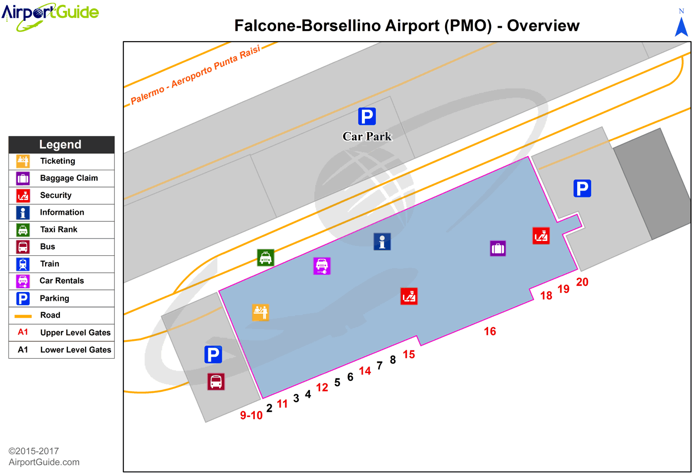
Maps & Diagrams
PMO Sectional
Flight Planning
at skyvector.com
at skyvector.com
