Location
Latitude: |
26-55-06.9330N (26.918593) |
Longitude: |
081-59-27.1900W (-81.990886) |
Elevation: |
25.5 feet MSL (8 m MSL) |
Magnetic Variation: |
6.2 W (as of April 2024 from WMM2020 model) |
Time Zone: |
UTC -5.0 (Standard Time) UTC -4.0 (Daylight Savings Time) |
From City: |
03 N.M. SE of Punta Gorda, Florida |
Found On: |
Miami Chart |
FAA Region: |
ASO |
Contacts
Manager: |
Publicly owned: |
| JAMES W PARISH 28000 A-1 AIRPORT RD PUNTA GORDA, FL 33982 941-639-1101 |
CHARLOTTE COUNTY ARPT AUTH 28000 A-1 AIRPORT RD PUNTA GORDA, FL 33982 941-639-1101 |
Operations
Airport Status: |
Operational |
Facility Use: |
Public |
Type: |
Airport |
Activation Date: |
02/1944 |
Control tower: |
Yes |
Attendance (Months/Days/Hours): |
Months/Days/Hours ALL/ALL/ALL |
Boundary ARTCC: |
ZMA (Miami) |
Responsible ARTCC: |
ZMA (Miami) |
Lighting Schedule: |
SEE RMK |
Segmented Circle Indicator: |
Yes |
Traffic Pattern Altitude (MSL): |
1026 feet (313 m) |
NOTAMs Facility: |
PGD |
NOTAM-D Service: |
Yes |
International Airport of Entry: |
No |
Customs Landing Rights: |
No |
Military Landing Rights: |
Yes |
Civil/Military Joint Use: |
No |
Aircraft Rescue and Firefighting: |
Class I ARFF Index: B Air Carrier Service: Scheduled Certification Date: 08/1975 |
Based Aircraft
| Single Engine: | 331 |
| Multi Engine: | 36 |
| Jet Engine: | 21 |
| GA Helicopters: | 11 |
| Gliders: | 1 |
| Ultralights: | 4 |
Annual Operations (as of 12/31/2023)
| Total Operations: | 103252 | |
| Commercial: | 12012 | 11.6% |
| Air Taxi: | 1454 | 1.4% |
| GA Local: | 38467 | 37.3% |
| GA Itinerant: | 49326 | 47.8% |
| Military Aircraft: | 1993 | 1.9% |
Communications
| CTAF: | 121.000 |
| Unicom: | 122.975 |
| Tower: | PUNTA GORDA 121.0 Hrs: 0600-2100 |
| Clearance Del.: | 119.55 |
| Ground: | 119.55 |
| Approach: | FORT MYERS MIAMI ARTCC |
| Departure: | FORT MYERS MIAMI ARTCC |
| ATIS: | 135.675 Hrs: 0600-2100 |
| ASOS: | 135.675 (941-639-0076) |
- APCH/DEP SVC PRVDD BY MIAMI ARTCC ON FREQS 134.75/322.5 (FORT MYERS RCAG) WHEN FORT MYERS APCH CTL CLSD.
- WHEN ATCT CLSD CLNC DEL 127.05 MONITORED BY FORT MYERS APCH CTL.
Fixed Based Operators (FBOs) & Fuel
(Click on a business for detail)
Please help us keep this information up to date. This is a FREE SERVICE just like everything else on Airport Guide! If you see that a business needs to be added, modified, or deleted please fill out our Update Form.
To add, modify, or delete a business click here.
Please help us keep this information up to date. This is a FREE SERVICE just like everything else on Airport Guide! If you see that a business needs to be added, modified, or deleted please fill out our Update Form.
Area Code: 941 |
| Business Name | Frequency | Phone | Fuel Grade |
|---|---|---|---|
| Airtrek, Inc.
Update FBO info |
Unicom 122.7 | 639-7855 | |
| Charlotte County Development Authority
Update FBO info |
Unicom 122.7 | 639-4119 | 100LL, Jet A |
| Eastern Avionics International, Inc.
Update FBO info |
Unicom 122.7 | 800-628-2667, 637-8585 | |
| Professional Aviation, Inc.
Update FBO info |
800-243-2359, 639-7071 |
Flight Service Stations
| Primary | Alternate | |
| FSS on Field: | N | |
| FSS Name (ID): | Saint Petersburg(PIE) | |
| Frequency: | ||
| Toll Free Phone: | 1-800-WX-BRIEF |
Instrument Procedures / Charts
FAA Terminal Procedures valid from 0901Z 03/21/24 to 0901Z 04/18/24.
There are various types of charts available for an airport. They are listed in the Page Type column. Here is a legend for those types:
APD - Airport Diagram
DP - Departure Procedure Charts
HOT - Hot Spots
IAP - Instrument Approach Procedure Charts
MIN - Minimums
STAR - Standard Terminal Arrival Charts
| Page Type | Page Name | Volume | Action Since Last Cycle |
|---|---|---|---|
| APD | AIRPORT DIAGRAM | SE-3 | |
| IAP | ILS OR LOC RWY 04 | SE-3 | |
| IAP | RNAV (GPS) RWY 04 | SE-3 | |
| IAP | RNAV (GPS) RWY 15 | SE-3 | |
| IAP | RNAV (GPS) RWY 22 | SE-3 | |
| IAP | RNAV (GPS) RWY 33 | SE-3 | |
| IAP | VOR RWY 04 | SE-3 | |
| IAP | VOR RWY 22 | SE-3 | |
| MIN | ALTERNATE MINIMUMS | SE-3 | |
| MIN | TAKEOFF MINIMUMS | SE-3 | |
| STAR | LUBBR THREE (RNAV) | SE-3 | |
| STAR | LUBBR THREE (RNAV)[DELIMITER] CONT.1 | SE-3 | |
| STAR | PIKKR SEVEN (RNAV) | SE-3 |
Terminal Procedures are only available for airports in several countries with more being added all the time. If you are looking for a specific country's charts, please send an email to support(at)airportguide.com stating the country name. This will be used to prioritize the implementation.
Navigation Aids (Navaids) near PGD
| Dist (NM) | ID | Morse Code | Name | Type | Freq | True Hdg | Mag Hdg |
|---|---|---|---|---|---|---|---|
| 0.1 | PGD | . _ _ . _ _ . _ . . | Punta Gorda | VOR | 110.20 | 188 | 194 |
| 24.2 | FM | . . _ . _ _ | Caloo | NDB | 341 | 174 | 180 |
| 25.0 | VNC | . . . _ _ . _ . _ . | Venice | NDB | 206 | 290 | 296 |
| 26.0 | RSW | . _ . . . . . _ _ | Lee County | VORTAC | 114.15 | 153 | 159 |
| 32.5 | LBV | . _ . . _ . . . . . . _ | La Belle | VORTAC | 110.40 | 99 | 105 |
| 42.4 | SRQ | . . . . _ . _ _ . _ | Sarasota | VOR-DME | 117.00 | 313 | 319 |
| 47.3 | CYY | _ . _ . _ . _ _ _ . _ _ | Cypress | VOR-DME | 108.60 | 165 | 171 |
| 63.0 | MCF | _ _ _ . _ . . . _ . | Macdill | TACAN | 111.00 | 333 | 339 |
| 63.8 | AM | . _ _ _ | Picny | NDB | 388 | 332 | 338 |
| 64.1 | LAL | . _ . . . _ . _ . . | Lakeland | VORTAC | 116.00 | 358 | 364 |
| 69.6 | TPA | _ . _ _ . . _ | Tampa Intl | VOT | 111.00 | 335 | 341 |
| 69.9 | PIE | . _ _ . . . . | St Petersburg | VORTAC | 116.40 | 328 | 334 |
| 70.0 | PHK | . _ _ . . . . . _ . _ | Pahokee | VOR-DME | 115.40 | 96 | 103 |
| 74.9 | PI | . _ _ . . . | Capok | NDB | 360 | 329 | 335 |
| 75.6 | TP | _ . _ _ . | Cosme | NDB | 368 | 338 | 344 |
| 79.0 | RHZ | . _ . . . . . _ _ . . | Zephyrhills | NDB | 253 | 353 | 359 |
| 82.4 | TN | _ _ . | Monry | NDB | 227 | 140 | 146 |
| 88.6 | UTX | . . _ _ _ . . _ | United | NDB | 405 | 89 | 96 |
| 92.1 | TRV | _ . _ . . . . _ | Treasure | VORTAC | 117.30 | 59 | 66 |
| 92.8 | FPR | . . _ . . _ _ . . _ . | Fort Pierce | NDB | 275 | 68 | 75 |
Nearby Airports with Fuel
Notices to Airmen (NOTAMS)
Remarks
| A110-6 | FOR CD IF UNA TO CTC ON FSS FREQ, CTC FT MYERS APCH AT 239-416-1026, WHEN APCH CLSD CTC MIAMI ARTCC AT 305-716-1731. |
| A16 | 941-639-1101 EXT123. |
| A30-09/27 | RSTRD TO ACFT LESS THAN 6000 LBS. NOT AVBL FOR SKED ACR OPS WITH MORE THAN 9 PAX SEATS OR UNSKED ACR AT LEAST 31 PAX SEATS. |
| A57-15 | RWY 15 APCH SLP 48:1 TO DTHR. |
| A70-FUEL-10 | 0LL FUEL 24 HR CREDIT CARD SVC AVBL. |
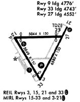
| A81-APT | ACTVT REIL RWY 04, 15, 22 & 33; PAPI RWY 04, 15, 22 & 33 - CTAF. HIRL RWY 04/22; MIRL RWY 15/33 PRESET ON LOW INTST; TO INCR INTST - CTAF. |
Runways
Runway Summary
| Runways: | 04/22 09/27 15/33 |
| Longest Runway: | 04/22 is 7193 ft (2192 m) long |
| Runways with an Instrument Approach: | 04 |
PGD Airport Runway Details
| Runway 04/22 | 7193 ft x 150 ft (2192 m x 46 m) | |
| Runway Length Source: | 3RD PARTY SURVEY as of 09/15/2020 | |
| Surface: | Asphalt - Fair condition - Saw-cut or plastic grooved | |
| Runway Pavement Class: | 40 /F/B/X/T | |
| Runway Edge Lights: | High Intensity | |
Runway Weight Bearing Capacity (in thousands of pounds) |
||
| Single Wheel Landing Gear: | 45.0 | |
| Dual Wheel Landing Gear: | 95.0 | |
| Dual Tandem Wheel Landing Gear: | 150.0 | |
| Dual Dual Tandem Wheel Landing Gear: | 420.0 | |
Runway 04 |
Runway 22 |
|
Elevation: |
23.2 | 25.4 |
Latitude: |
26-54-36.6520N | 26-55-38.8483N |
Longitude: |
081-59-31.7250W | 081-58-52.9939W |
|
Runway True Alignment: |
029 | 209 |
ILS Type: |
ILS/DME | |
Glide Path Angle: |
3.0 degrees | 3.0 degrees |
Traffic Pattern: |
Left | Left |
Runway Markings Type: |
Precision Instrument | Nonprecision Instrument |
Runway Markings Condition: |
Good | Good |
Object at End: |
TREES | |
Object Height: |
31 | |
Distance from End: |
1770 | |
Object Centerline Offset: |
390 ft. right of centerline | |
Visual Glide Slope Indicators: |
4-Light PAPI On Left Side Of Runway | 4-Light PAPI On Left Side Of Runway |
REIL: |
Yes | Yes |
Threshold Crossing Height: |
50 | 31 |
| Runway 09/27 | 2636 ft x 60 ft (803 m x 18 m) | |
| Runway Length Source: | 3RD PARTY SURVEY as of 09/15/2020 | |
| Surface: | Asphalt - Fair condition - No special surface treatment | |
| Runway Pavement Class: | 5 /F/C/Y/T | |
Runway 09 |
Runway 27 |
|
Elevation: |
19.1 | 22.1 |
Latitude: |
26-55-24.6315N | 26-55-25.0078N |
Longitude: |
081-59-53.3687W | 081-59-24.2486W |
|
Runway True Alignment: |
089 | 269 |
Glide Path Angle: |
0.0 degrees | 0.0 degrees |
Traffic Pattern: |
Left | Left |
Runway Markings Type: |
Basic | Basic |
Runway Markings Condition: |
Poor | Poor |
Object at End: |
TREES | |
Object Height: |
40 | |
Distance from End: |
2210 | |
Object Centerline Offset: |
390 ft. right of centerline | |
Declared Distances |
||
Take Off Run Avbl. (TORA): |
2635 | 2635 |
Take Off Distance Avbl. (TODA): |
2635 | 2635 |
Actual Stop Dist. Avbl. (ASDA): |
2635 | 2635 |
Landing Dist. Avbl. (LDA): |
2635 | 2635 |
| Runway 15/33 | 6286 ft x 150 ft (1916 m x 46 m) | |
| Runway Length Source: | 3RD PARTY SURVEY as of 09/15/2020 | |
| Surface: | Asphalt - Fair condition - Saw-cut or plastic grooved | |
| Runway Pavement Class: | 37 /F/B/X/T | |
| Runway Edge Lights: | Medium Intensity | |
Runway Weight Bearing Capacity (in thousands of pounds) |
||
| Single Wheel Landing Gear: | 45.0 | |
| Dual Wheel Landing Gear: | 80.0 | |
| Dual Tandem Wheel Landing Gear: | 140.0 | |
Runway 15 |
Runway 33 |
|
Elevation: |
18.5 | 23.0 |
Latitude: |
26-55-25.2242N | 26-54-31.7686N |
Longitude: |
081-59-57.0779W | 081-59-21.4968W |
|
Runway True Alignment: |
149 | 329 |
Glide Path Angle: |
3.0 degrees | 3.0 degrees |
Traffic Pattern: |
Left | Left |
Runway Markings Type: |
Nonprecision Instrument | Nonprecision Instrument |
Runway Markings Condition: |
Good | Good |
Object at End: |
ROAD | TREES |
Object Height: |
15 | 54 |
Distance from End: |
460 | 2375 |
Object Centerline Offset: |
390 ft. right of centerline | |
Visual Glide Slope Indicators: |
4-Light PAPI On Left Side Of Runway | 4-Light PAPI On Left Side Of Runway |
REIL: |
Yes | Yes |
Threshold Crossing Height: |
47 | 48 |
Threshold Elevation: |
19.4 | |
Displaced Threshold: |
271 | |
Threshold Latitude: |
26-55-22.9197N | |
Threshold Longitude: |
081-59-55.5496W | |
Declared Distances |
||
Take Off Run Avbl. (TORA): |
6286 | 6166 |
Take Off Distance Avbl. (TODA): |
6286 | 6166 |
Actual Stop Dist. Avbl. (ASDA): |
6286 | 6015 |
Landing Dist. Avbl. (LDA): |
6015 | 6015 |
Services
Airframe Repair: |
Major |
Powerplant Repair: |
Major |
Bottled Oxygen: |
Low Pressure |
Bulk Oxygen: |
High Pressure / Low Pressure |
Fuel Available: |
100LL, Jet A |
Landing Fees: |
No |
Parking: |
Hangars and tiedowns available |
Maps & Diagrams
PGD Sectional
Flight Planning
at skyvector.com
at skyvector.com