Location
Latitude: |
41-13-34.0000N (41.226111) |
Longitude: |
092-29-37.8000W (-92.493833) |
Elevation: |
840.2 feet MSL (256 m MSL) |
Magnetic Variation: |
0.4 W (as of April 2024 from WMM2020 model) |
Time Zone: |
UTC -6.0 (Standard Time) UTC -5.0 (Daylight Savings Time) |
From City: |
09 N.M. SE of Oskaloosa, Iowa |
Found On: |
Chicago Chart |
FAA Region: |
ACE |
Contacts
Manager: |
Publicly owned: |
| SHANE VANDE VOORT 2973 URBANA AVENUE OSKALOOSA, IA 52577 641-933-4316 |
CITY OF OSKALOOSA 220 SOUTH MARKET OSKALOOSA, IA 52577 641-673-9431 |
Operations
Airport Status: |
Operational |
Facility Use: |
Public |
Type: |
Airport |
Activation Date: |
10/1959 |
Control tower: |
No |
Attendance (Months/Days/Hours): |
Months/Days/Hours MAY-SEP/MON - FRI/0800-1800 |
Boundary ARTCC: |
ZAU (Chicago) |
Responsible ARTCC: |
ZAU (Chicago) |
Lighting Schedule: |
SEE RMK |
Segmented Circle Indicator: |
No |
Traffic Pattern Altitude (MSL): |
1840 feet (561 m) |
NOTAMs Facility: |
OOA |
NOTAM-D Service: |
Yes |
International Airport of Entry: |
No |
Customs Landing Rights: |
No |
Military Landing Rights: |
Yes |
Civil/Military Joint Use: |
No |
Based Aircraft
| Single Engine: | 22 |
Annual Operations (as of 09/21/2023)
| Total Operations: | 6250 | |
| Air Taxi: | 405 | 6.5% |
| GA Local: | 3238 | 51.8% |
| GA Itinerant: | 2607 | 41.7% |
Communications
| CTAF: | 122.800 |
| Unicom: | 122.800 |
| AWOS-3: | 118.625 (641-933-4312) |
- APCH/DEP SVC PRVDD BY CHICAGO ARTCC ON FREQS 118.15/335.575 (OTTUMWA RCAG).
Fixed Based Operators (FBOs) & Fuel
(Click on a business for detail)
Please help us keep this information up to date. This is a FREE SERVICE just like everything else on Airport Guide! If you see that a business needs to be added, modified, or deleted please fill out our Update Form.
To add, modify, or delete a business click here.
Please help us keep this information up to date. This is a FREE SERVICE just like everything else on Airport Guide! If you see that a business needs to be added, modified, or deleted please fill out our Update Form.
Area Code: 515 |
| Business Name | Frequency | Phone | Fuel Grade |
|---|
Flight Service Stations
| Primary | Alternate | |
| FSS on Field: | N | |
| FSS Name (ID): | Fort Dodge(FOD) | |
| Frequency: | ||
| Toll Free Phone: | 1-800-WX-BRIEF |
Instrument Procedures / Charts
FAA Terminal Procedures valid from 0901Z 03/21/24 to 0901Z 04/18/24.
There are various types of charts available for an airport. They are listed in the Page Type column. Here is a legend for those types:
APD - Airport Diagram
DP - Departure Procedure Charts
HOT - Hot Spots
IAP - Instrument Approach Procedure Charts
MIN - Minimums
STAR - Standard Terminal Arrival Charts
| Page Type | Page Name | Volume | Action Since Last Cycle |
|---|---|---|---|
| IAP | RNAV (GPS) RWY 13 | NC-3 | |
| IAP | RNAV (GPS) RWY 31 | NC-3 | |
| MIN | ALTERNATE MINIMUMS | NC-3 | |
| MIN | TAKEOFF MINIMUMS | NC-3 |
Terminal Procedures are only available for airports in several countries with more being added all the time. If you are looking for a specific country's charts, please send an email to support(at)airportguide.com stating the country name. This will be used to prioritize the implementation.
Navigation Aids (Navaids) near OOA
| Dist (NM) | ID | Morse Code | Name | Type | Freq | True Hdg | Mag Hdg |
|---|---|---|---|---|---|---|---|
| 0.3 | OOA | _ _ _ _ _ _ . _ | Oskaloosa | NDB | 414 | 97 | 97 |
| 14.0 | OTM | _ _ _ _ _ _ | Ottumwa | VOR-DME | 111.60 | 147 | 147 |
| 23.0 | PEA | . _ _ . . . _ | Pella | NDB | 257 | 297 | 297 |
| 26.3 | FFL | . . _ . . . _ . . _ . . | Fairfield | NDB | 332 | 119 | 120 |
| 29.0 | BEX | _ . . . . _ . . _ | Bloomfield | NDB | 269 | 174 | 174 |
| 37.2 | AWG | . _ . _ _ _ _ . | Washington | NDB | 219 | 84 | 85 |
| 43.4 | IOW | . . _ _ _ . _ _ | Iowa City | VOR-DME | 116.20 | 65 | 66 |
| 43.4 | TNU | _ _ . . . _ | Newton | VOR-DME | 112.50 | 320 | 320 |
| 47.3 | MPZ | _ _ . _ _ . _ _ . . | Mount Pleasant | NDB | 212 | 110 | 111 |
| 50.8 | CID | _ . _ . . . _ . . | Cedar Rapids | VOR-DME | 114.10 | 38 | 39 |
| 53.6 | DSM | _ . . . . . _ _ | Des Moines | VORTAC | 117.50 | 284 | 284 |
| 55.6 | DSM | _ . . . . . _ _ | Des Moines | VOT | 109.20 | 290 | 290 |
| 56.3 | JWJ | . _ _ _ . _ _ . _ _ _ | Elmwood | DME | 109.4 | 340 | 340 |
| 61.2 | DDD | _ . . _ . . _ . . | Port City | DME | 116.5 | 81 | 82 |
| 65.6 | IRK | . . . _ . _ . _ | Kirksville | VORTAC | 114.60 | 183 | 183 |
| 66.2 | EE | . . | Merle | NDB | 362 | 308 | 308 |
| 66.4 | EOK | . _ _ _ _ . _ | Keokuk | NDB | 366 | 133 | 134 |
| 71.0 | BR | _ . . . . _ . | Burns | NDB | 390 | 118 | 119 |
| 76.8 | LMN | . _ . . _ _ _ . | Lamoni | VOR-DME | 116.70 | 241 | 241 |
| 77.2 | BRL | _ . . . . _ . . _ . . | Burlington | VOR-DME | 111.40 | 112 | 113 |
Nearby Airports with Fuel
Notices to Airmen (NOTAMS)
Remarks
| A110-1 | FOR CD CTC CHICAGO ARTCC AT 630-906-8921. |
| A17 | 641-933-4316 |
| A81-APT | ACTVT MIRL RWY 13/31; REIL RWY 13/31 - CTAF. |
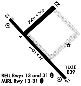
Runways
Runway Summary
| Runways: | 04/22 13/31 |
| Longest Runway: | 13/31 is 4012 ft (1223 m) long |
| Runways with an Instrument Approach: |
OOA Airport Runway Details
| Runway 04/22 | 1926 ft x 75 ft (587 m x 23 m) | |
| Runway Length Source: | 3RD PARTY SURVEY as of 05/22/2008 | |
| Surface: | Concrete - Fair condition - No special surface treatment | |
| Runway Pavement Class: | 6 /R/D/W/U | |
Runway Weight Bearing Capacity (in thousands of pounds) |
||
| Single Wheel Landing Gear: | 25.0 | |
Runway 04 |
Runway 22 |
|
Elevation: |
837.5 | 839.8 |
Latitude: |
41-13-36.7205N | 41-13-50.2759N |
Longitude: |
092-29-46.7486W | 092-29-29.0641W |
|
Runway True Alignment: |
045 | 225 |
Glide Path Angle: |
0.0 degrees | 0.0 degrees |
Traffic Pattern: |
Left | Left |
Runway Markings Type: |
Nonprecision Instrument | Nonprecision Instrument |
Runway Markings Condition: |
Fair | Fair |
| Runway 13/31 | 4012 ft x 75 ft (1223 m x 23 m) | |
| Runway Length Source: | 3RD PARTY SURVEY as of 05/22/2008 | |
| Surface: | Concrete - Fair condition - No special surface treatment | |
| Runway Pavement Class: | 8 /R/C/W/T | |
| Runway Edge Lights: | Medium Intensity | |
Runway Weight Bearing Capacity (in thousands of pounds) |
||
| Single Wheel Landing Gear: | 25.0 | |
Runway 13 |
Runway 31 |
|
Elevation: |
837.3 | 835.7 |
Latitude: |
41-13-43.3921N | 41-13-15.5771N |
Longitude: |
092-29-56.4231W | 092-29-19.0122W |
|
Runway True Alignment: |
135 | 315 |
Glide Path Angle: |
3.0 degrees | 3.0 degrees |
Traffic Pattern: |
Left | Left |
Runway Markings Type: |
Nonprecision Instrument | Nonprecision Instrument |
Runway Markings Condition: |
Good | Good |
Visual Glide Slope Indicators: |
2-Light PAPI On Left Side Of Runway | 2-Light PAPI On Left Side Of Runway |
REIL: |
Yes | Yes |
Threshold Crossing Height: |
22 | 22 |
Services
Airframe Repair: |
Major |
Powerplant Repair: |
Major |
Bottled Oxygen: |
None |
Bulk Oxygen: |
None |
Fuel Available: |
100LL, Jet A, MOGAS |
Landing Fees: |
No |
Parking: |
Hangars and tiedowns available |
Maps & Diagrams
OOA Sectional
Flight Planning
at skyvector.com
at skyvector.com