
Location
Latitude: |
48-21-13.6872N (48.353802) |
Longitude: |
011-47-09.96E (11.7861) |
Elevation: |
1487 feet MSL (453 m MSL) |
Magnetic Variation: |
4.2 E (as of April 2024 from WMM2020 model) |
Time Zone: |
UTC +1.0 (Standard Time) UTC +2.0 (Daylight Savings Time) |
Contacts
Manager: |
: |
Operations
Airport Status: |
Operational |
Facility Use: |
Public |
Type: |
Airport |
Traffic Pattern Altitude (MSL): |
2487 feet (758 m) |
Based Aircraft
Annual Operations (as of )
Communications
| TWR: | 118.7 |
| INFO: | 120.65 |
| CLNC DEL: | 121.725 |
| Apron 1: | 121.775 |
| GND: | 119.4 |
| Apron 2: | 121.7 |
| RADAR: | 123.9 |
| LCL RADAR: | 131.225 |
| ATIS: | 123.13 |
| ARR: | 120.775 |
| DIRECTOR: | 118.825 |
| Aron 3: | 121.925 |
Fixed Based Operators (FBOs) & Fuel
(Click on a business for detail)
Please help us keep this information up to date. This is a FREE SERVICE just like everything else on Airport Guide! If you see that a business needs to be added, modified, or deleted please fill out our Update Form.
To add, modify, or delete a business click here.
Please help us keep this information up to date. This is a FREE SERVICE just like everything else on Airport Guide! If you see that a business needs to be added, modified, or deleted please fill out our Update Form.
| Business Name | Frequency | Phone | Fuel Grade |
|---|
Flight Service Stations
| Primary | Alternate | |
| FSS on Field: | ||
| FSS Name (ID): | ||
| Frequency: | ||
| Toll Free Phone: |
Instrument Procedures / Charts
Terminal Procedures are only available for airports in several countries with more being added all the time. If you are looking for a specific country's charts, please send an email to support(at)airportguide.com stating the country name. This will be used to prioritize the implementation.
Navigation Aids (Navaids) near MUC
| Dist (NM) | ID | Morse Code | Name | Type | Freq | True Hdg | Mag Hdg |
|---|---|---|---|---|---|---|---|
| 0.8 | DMN | Munchen | DME | 116.00 | 21 | 17 | |
| 0.8 | DMS | Munchen | DME | 108.60 | 201 | 197 | |
| 4.4 | MNE | Munchen | NDB | 369 | 271 | 267 | |
| 4.7 | MSW | Munchen | NDB | 400 | 90 | 86 | |
| 5.2 | MNW | Munchen | NDB | 338 | 76 | 72 | |
| 5.5 | MSE | Munchen | NDB | 358 | 257 | 253 | |
| 6.9 | ERD | Erding | TACAN | 113.60 | 104 | 100 | |
| 10.5 | MUN | Munchen | VOR-DME | 112.30 | 173 | 169 | |
| 15.0 | MIQ | Mike | NDB | 427 | 330 | 326 | |
| 19.7 | MAH | Maisach | VOR-DME | 115.20 | 254 | 250 | |
| 23.0 | MBG | Moosburg | VOR-DME | 117.15 | 54 | 50 | |
| 23.1 | MDF | Milldorf | VOR-DME | 117.00 | 107 | 103 | |
| 23.5 | IGL | Ingolstadt | TACAN | 111.40 | 338 | 334 | |
| 23.7 | IGL | Ingolstadt | NDB | 345 | 346 | 342 | |
| 25.9 | OBI | Oberpfaffenhofen | NDB-DME | 429 | 230 | 226 | |
| 29.4 | WLD | Walda | VOR-DME | 112.80 | 297 | 293 | |
| 31.4 | NEU | Neuburg | TACAN | 108.90 | 313 | 309 | |
| 34.2 | AGB | Augsburg | NDB | 318 | 277 | 273 | |
| 34.3 | AUG | Augsburg | DME | 115.90 | 277 | 273 | |
| 34.4 | LQ | Landsberg | NDB | 448 | 243 | 239 |
Nearby Airports with Fuel
| Dist (NM) | Name (Airport IDs) | True Hdg | Mag Hdg | Fuel Grade |
|---|
Notices to Airmen (NOTAMS)
Remarks
No remarks for this landing facility
Runways
Runway Summary
| Runways: | 08L/26R 08R/26L |
| Longest Runway: | 08L/26R is 13123 ft (4000 m) long |
| Runways with an Instrument Approach: |
MUC Airport Runway Details
| Runway 08L/26R | 13123 ft x 197 ft (4000 m x 60 m) | |
| Runway Edge Lights: | Yes Intensity | |
Runway 08L |
Runway 26R |
|
Elevation: |
1467 | 1449 |
Latitude: |
48.36280059814 | 48.36690139770 |
Longitude: |
11.767600059509 | 11.821200370788 |
|
Runway True Alignment: |
83.4 | 263.4 |
Glide Path Angle: |
0.0 degrees | 0.0 degrees |
REIL: |
Yes | Yes |
Threshold Elevation: |
1467 | 1449 |
| Runway 08R/26L | 13123 ft x 197 ft (4000 m x 60 m) | |
| Runway Edge Lights: | Yes Intensity | |
Runway 08R |
Runway 26L |
|
Elevation: |
1486 | 1470 |
Latitude: |
48.34069824218 | 48.34479904174 |
Longitude: |
11.751000404357 | 11.804599761962 |
|
Runway True Alignment: |
83.4 | 263.4 |
Glide Path Angle: |
0.0 degrees | 0.0 degrees |
REIL: |
Yes | Yes |
Threshold Elevation: |
1486 | 1470 |
Services
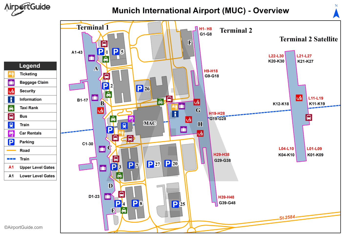
Maps & Diagrams
MUC Sectional
Flight Planning
at skyvector.com
at skyvector.com
