Location
Latitude: |
36-35-13.0280N (36.586952) |
Longitude: |
121-50-34.0190W (-121.842783) |
Elevation: |
256.6 feet MSL (78 m MSL) |
Magnetic Variation: |
12.7 E (as of April 2024 from WMM2020 model) |
Time Zone: |
UTC -8.0 (Standard Time) UTC -7.0 (Daylight Savings Time) |
From City: |
03 N.M. SE of Monterey, California |
Found On: |
San Francisco Chart |
FAA Region: |
AWP |
Contacts
Manager: |
Publicly owned: |
| MICHAEL LA PIER 200 FRED KANE DR., SUITE 200 MONTEREY, CA 93940 831-648-7000 |
MONTEREY PENIN ARPT DIST 200 FRED KANE DR., SUITE 200 MONTEREY, CA 93940 831-648-7000 |
Operations
Airport Status: |
Operational |
Facility Use: |
Public |
Type: |
Airport |
Activation Date: |
04/1940 |
Control tower: |
Yes |
Attendance (Months/Days/Hours): |
Months/Days/Hours ALL/ALL/ALL |
Boundary ARTCC: |
ZOA (Oakland) |
Responsible ARTCC: |
ZOA (Oakland) |
Lighting Schedule: |
SEE RMK |
Segmented Circle Indicator: |
Yes |
Traffic Pattern Altitude (MSL): |
1257 feet (383 m) |
NOTAMs Facility: |
MRY |
NOTAM-D Service: |
Yes |
International Airport of Entry: |
No |
Customs Landing Rights: |
Yes |
Military Landing Rights: |
Yes |
Aircraft Rescue and Firefighting: |
Class I ARFF Index: B Air Carrier Service: Scheduled Certification Date: 05/1973 |
Based Aircraft
| Single Engine: | 111 |
| Multi Engine: | 8 |
| Jet Engine: | 27 |
Annual Operations (as of 12/31/2023)
| Total Operations: | 54206 | |
| Commercial: | 6586 | 12.1% |
| Air Taxi: | 10338 | 19.1% |
| GA Local: | 9651 | 17.8% |
| GA Itinerant: | 25886 | 47.8% |
| Military Aircraft: | 1745 | 3.2% |
Communications
| CTAF: | 118.400 |
| Unicom: | 122.950 |
| Tower: | MONTEREY 118.4 257.8 Hrs: 0600-2100 |
| Clearance Del.: | 135.45 |
| Ground: | 120.875 348.6 |
| Approach: | NORCAL |
| Departure: | NORCAL |
| ATIS: | 119.25 Hrs: 24 |
| ASOS: | (831-642-0241) |
| EMERG: | 121.5 |
| EMERG: | 243.0 |
- STAGE-III SVC NOT AVBL WITHIN SALINAS ATA.
- ASR-11 ANTENNA LOCATED MARINA MUNI (OAR), REMOTED TO MONTEREY RGNL (MRY). ASR-11 SERVES MRY AND OAR.
Fixed Based Operators (FBOs) & Fuel
(Click on a business for detail)
Please help us keep this information up to date. This is a FREE SERVICE just like everything else on Airport Guide! If you see that a business needs to be added, modified, or deleted please fill out our Update Form.
To add, modify, or delete a business click here.
Please help us keep this information up to date. This is a FREE SERVICE just like everything else on Airport Guide! If you see that a business needs to be added, modified, or deleted please fill out our Update Form.
Area Code: 831 |
| Business Name | Frequency | Phone | Fuel Grade |
|---|---|---|---|
| Del Monte Aviation, Inc.
Update FBO info |
Unicom 122.95 | 373-4151, for maintenance call 373-1511 | 100LL |
| Million Air Monterey
Update FBO info |
Unicom 122.95 | 373-4151 | 100LL, Jet A |
| Monterey Airplane Company
Update FBO info |
375-7518 | ||
| Monterey Jet Center
Website Update FBO info |
Unicom 122.95/Arinc 129.77 | 373-0100 | 100LL, Jet A |

|
Chevron |
100LL - 2.90 USD per gallon on 9/13/01 |
Trucks Volume discounts available. Price includes all taxes. |
|
|
Chevron |
Jet A - 2.34 USD per gallon on 9/13/01 |
Trucks Add $0.05 / per gallon for Jet A with Prist. Volume discounts available. Price includes all taxes. |
Flight Service Stations
| Primary | Alternate | |
| FSS on Field: | N | |
| FSS Name (ID): | Oakland(OAK) | |
| Frequency: | ||
| Toll Free Phone: | 1-800-WX-BRIEF |
Instrument Procedures / Charts
FAA Terminal Procedures valid from 0901Z 03/21/24 to 0901Z 04/18/24.
There are various types of charts available for an airport. They are listed in the Page Type column. Here is a legend for those types:
APD - Airport Diagram
DP - Departure Procedure Charts
HOT - Hot Spots
IAP - Instrument Approach Procedure Charts
MIN - Minimums
STAR - Standard Terminal Arrival Charts
| Page Type | Page Name | Volume | Action Since Last Cycle |
|---|---|---|---|
| APD | AIRPORT DIAGRAM | SW-2 | |
| DP | MONTEREY FIVE | SW-2 | |
| DP | TORO SEVEN | SW-2 | |
| IAP | ILS OR LOC RWY 10R | SW-2 | |
| IAP | LOC RWY 28L | SW-2 | |
| IAP | RACEWAY VISUAL RWY 28L | SW-2 | |
| IAP | RNAV (GPS) RWY 10R | SW-2 | |
| IAP | RNAV (GPS) Y RWY 28L | SW-2 | |
| IAP | RNAV (RNP) Z RWY 28L | SW-2 | |
| MIN | ALTERNATE MINIMUMS | SW-2 | |
| MIN | DIVERSE VECTOR AREA | SW-2 | |
| MIN | TAKEOFF MINIMUMS | SW-2 |
Terminal Procedures are only available for airports in several countries with more being added all the time. If you are looking for a specific country's charts, please send an email to support(at)airportguide.com stating the country name. This will be used to prioritize the implementation.
Navigation Aids (Navaids) near MRY
| Dist (NM) | ID | Morse Code | Name | Type | Freq | True Hdg | Mag Hdg |
|---|---|---|---|---|---|---|---|
| 5.0 | MR | _ _ . _ . | Munso | NDB | 385 | 293 | 280 |
| 12.4 | SNS | . . . _ . . . . | Salinas | VORTAC | 117.30 | 68 | 55 |
| 18.6 | UAD | . . _ . _ _ . . | Chualar | NDB | 263 | 107 | 94 |
| 19.7 | PDG | . _ _ . _ . . _ _ . | Pajar | NDB | 327 | 4 | 351 |
| 21.3 | WVI | . _ _ . . . _ . . | Watsonville | DME | 114.25 | 7 | 354 |
| 26.2 | BSR | _ . . . . . . . _ . | Big Sur | VORTAC | 114.00 | 158 | 145 |
| 47.5 | SJC | . . . . _ _ _ _ . _ . | San Jose | VOR-DME | 114.10 | 354 | 341 |
| 49.1 | HGT | . . . . _ _ . _ | Hunter Liggett | NDB | 209 | 139 | 126 |
| 51.8 | NUQ | _ . . . _ _ _ . _ | Moffett | TACAN | 117.60 | 348 | 335 |
| 51.8 | PXN | . _ _ . _ . . _ _ . | Panoche | VORTAC | 112.60 | 81 | 68 |
| 52.7 | OSI | _ _ _ . . . . . | Woodside | VOR-DME | 113.90 | 336 | 323 |
| 62.9 | ROM | . _ . _ _ _ _ _ | Priest | VOR | 110.00 | 114 | 101 |
| 66.7 | LV | . _ . . . . . _ | Reiga | NDB | 374 | 6 | 353 |
| 66.9 | SFO | . . . . . _ . _ _ _ | San Francisco | VOT | 111.00 | 338 | 325 |
| 67.0 | SFO | . . . . . _ . _ _ _ | San Francisco | VOR-DME | 115.80 | 337 | 324 |
| 69.0 | TCY | _ _ . _ . _ . _ _ | Tracy | NDB | 203 | 15 | 2 |
| 70.7 | OAK | _ _ _ . _ _ . _ | Oakland | VOR-DME | 116.80 | 345 | 332 |
| 75.4 | MOD | _ _ _ _ _ _ . . | Modesto | VOR-DME | 114.60 | 33 | 20 |
| 78.9 | HYP | . . . . _ . _ _ . _ _ . | El Nido | VOR-DME | 114.20 | 60 | 47 |
| 80.5 | PRB | . _ _ . . _ . _ . . . | Paso Robles | VORTAC | 114.30 | 132 | 120 |
Nearby Airports with Fuel
Notices to Airmen (NOTAMS)
Remarks
| A110-12 | ATCT NON-VISIBILITY AREA TAXIWAY ALPHA EAST HOLDING BAY. |
| A110-13 | ACFT WITH WINGSPAN GREATER THAN 65' PROHIBITED ON TWY BRAVO BETWEEN TWY ECHO AND TWY DELTA. |
| A110-14 | FACILITY CONSTRAINTS FOR COMMERCIAL DIVERSIONS: ADG III AND LARGER WITH SEATING CAPACITY MORE THEN 150 PAX ARE HIGHLY DISCOURAGED. CBP PROCESSING FACILITIES UNAVAILABLE. |
| A110-15 | FOR CD OR CNL IFR WHEN ATCT CLSD, CTC NORCAL APP CON ON 133.5; IF UNA, CTC NORCAL APCH AT 916-361-3748. |
| A110-16 | FIRE STN APN CLSD TO HEL TFC. |
| A110-17 | AVOID FLYING RWY 28L RNAV Y WHEN POSS TO RDC NOISE IMPACTS. |
| A110-18 | RWY 28L RNAV AND RNP APCHS ARE NOT TO BE USED FOR PRACTICE APCHS. |
| A110-19 | RWY 10L/28R NOT AVBL FOR ACR USE. |
| A110-2 | ROTARY WING ACFT EXPECT TO FOLLOW FIXED WING PAT TO RWY LNDG. |
| A110-3 | LTD TRANSIENT PARKING PPR REQUIRED FOR LARGE AND TURBINE POWERED MULT ENG ACFT; (831) 648-7000 OPTION 2. |
| A110-5 | ON DEP NO TURNS BLO 900 FT UNLESS ATC DIRECTED. |
| A110-6 | NOISE ABATEMENT PROCEDURES IN EFFECT 2300-0700. |
| A110-7 | PLEASE AVOID FLTS OVR RESIDENTIAL AREAS, N AND S. CTC ARPT OPNS 831-648-7000 OPTION 2 OR WWW.MONTEREYAIRPORT.COM FOR PROCS. |
| A110-9 | ACFT WITH WINGSPAN GREATER THAN 95 FT MAY NOT TAXI PAST THE TERMINAL ON TWY ALPHA WHEN AN MD-80 OR 757 IS PARKED AT TERMINAL. |
| A14 | ARPT OPS DUTY MGR, 831-648-7000 X400; OPERATIONS@MONTEREYAIRPORT.COM. |
| A24 | CTC FBO FOR RATES AND CHARGES. LNDG FEE CHARGED FOR ACFT OVER 6,000 LBS AND HELICOPTERS. OVERNIGHT TIEDOWN FEE AT FBO. |
| A26 | RWY 10L/28R NOT AVBL FOR SKED ACR OPNS WITH MORE THAN 9 PSGR SEATS OR UNSKED ACR AT LEAST 31 PSGR SEATS. |
| A43-28L | UNUSBL BYD 2 DEG L OF RWY CNTRLN AND WI .75 NM OF RWY THR. |
| A57-28L | APCH RATIO 50:1 TO DSPLCD THR. |
| A81-APT | WHEN ATCT CLSD, ACTVT MALSR RWY 10R, REIL RWY 28L, PAPI RWY 10L, 10R, 28L & 28R, HIRL RWY 10R/28L - CTAF. WHEN ATCT CLOSED REIL RWY 10L & 28R; MIRL RWY 10L/28R UNAVBL. |
| E60-10R | ENGINEERED MATERIAL ARRESTING SYSTEM (EMAS) 389 FT IN LENGTH BY 170 FT IN WIDTH LCTD AT THE DER 10R. |
| E60-28L | ENGINEERED MATERIAL ARRESTING SYSTEM (EMAS) 389 FT IN LENGTH BY 170 FT IN WIDTH LCTD AT THE DER 28L. |
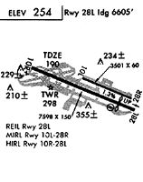
Runways
Runway Summary
| Runways: | 10L/28R 10R/28L |
| Longest Runway: | 10R/28L is 7175 ft (2187 m) long |
| Runways with an Instrument Approach: | 10R, 28L |
MRY Airport Runway Details
| Runway 10L/28R | 3503 ft x 60 ft (1068 m x 18 m) | |
| Runway Length Source: | 3RD PARTY SURVEY as of 05/16/2011 | |
| Surface: | Asphalt - Fair condition - No special surface treatment | |
| Runway Edge Lights: | Medium Intensity | |
Runway Weight Bearing Capacity (in thousands of pounds) |
||
| Single Wheel Landing Gear: | 12.5 | |
Runway 10L |
Runway 28R |
|
Elevation: |
198.1 | 256.1 |
Latitude: |
36-35-18.8949N | 36-35-05.4860N |
Longitude: |
121-50-40.6812W | 121-50-01.0801W |
|
Runway True Alignment: |
113 | 293 |
Glide Path Angle: |
3.0 degrees | 3.9 degrees |
Traffic Pattern: |
Right | |
Runway Markings Type: |
Basic | Basic |
Runway Markings Condition: |
Good | Good |
Visual Glide Slope Indicators: |
2-Light PAPI On Left Side Of Runway | 2-Light PAPI On Left Side Of Runway |
REIL: |
Yes | Yes |
Threshold Crossing Height: |
46 | 49 |
| Runway 10R/28L | 7175 ft x 150 ft (2187 m x 46 m) | |
| Runway Length Source: | FAA as of 06/04/2015 | |
| Surface: | Asphalt - Fair condition - Saw-cut or plastic grooved | |
| Runway Pavement Class: | 43 /F/A/X/U | |
| Runway Edge Lights: | High Intensity | |
Runway Weight Bearing Capacity (in thousands of pounds) |
||
| Single Wheel Landing Gear: | 100.0 | |
| Dual Wheel Landing Gear: | 160.0 | |
| Dual Tandem Wheel Landing Gear: | 300.0 | |
Runway 10R |
Runway 28L |
|
Elevation: |
158.3 | 256.6 |
Latitude: |
36-35-27.1540N | 36-34-59.7150N |
Longitude: |
121-51-21.0030W | 121-49-59.8680W |
|
Runway True Alignment: |
113 | 293 |
ILS Type: |
ILS/DME | LOC/DME |
Glide Path Angle: |
3.0 degrees | 3.5 degrees |
Traffic Pattern: |
Left | Right |
Runway Markings Type: |
Precision Instrument | Precision Instrument |
Runway Markings Condition: |
Good | Good |
Arresting Device: |
EMAS | EMAS |
Visual Glide Slope Indicators: |
4-Light PAPI On Left Side Of Runway | 4-Light PAPI On Right Side Of Runway |
Runway Visual Range (RVR): |
Touchdown, Rollout | Touchdown, Rollout |
Approach Light System: |
1,400 Foot Medium Intensity Approach Lighting System With Runway Alignment Indicator Lights | |
REIL: |
No | Yes |
Touchdown Lights: |
No | No |
Centerline Lights: |
No | No |
Threshold Crossing Height: |
47 | 45 |
Threshold Elevation: |
160.2 | 255.3 |
Displaced Threshold: |
175 | 175 |
Threshold Latitude: |
36-35-26.4840N | 36-35-00.3840N |
Threshold Longitude: |
121-51-19.0240W | 121-50-01.8460W |
Declared Distances |
||
Take Off Run Avbl. (TORA): |
7175 | 7175 |
Take Off Distance Avbl. (TODA): |
7175 | 7175 |
Actual Stop Dist. Avbl. (ASDA): |
7175 | 7175 |
Landing Dist. Avbl. (LDA): |
7000 | 7000 |
Services
Fuel Available: |
100LL |
Parking: |
Tiedowns available |
Other Services: |
Skydiving instruction |
Maps & Diagrams
MRY Sectional
Flight Planning
at skyvector.com
at skyvector.com