Location
Latitude: |
37-07-56.8000N (37.132444) |
Longitude: |
092-05-02.3000W (-92.083972) |
Elevation: |
1220.1 feet MSL (372 m MSL) |
Magnetic Variation: |
0.5 W (as of April 2024 from WMM2020 model) |
Time Zone: |
UTC -6.0 (Standard Time) UTC -5.0 (Daylight Savings Time) |
From City: |
01 N.M. NE of Cabool, Missouri |
Found On: |
Kansas City Chart |
FAA Region: |
ACE |
Contacts
Manager: |
Publicly owned: |
| RON SCHEETS BOX 710, 618 MAIN ST CABOOL, MO 65689 417-962-3136 |
CITY OF CABOOL BOX 710, 618 MAIN ST. CABOOL, MO 65689 417-962-3136 |
Operations
Airport Status: |
Operational |
Facility Use: |
Public |
Type: |
Airport |
Activation Date: |
10/1949 |
Control tower: |
No |
Attendance (Months/Days/Hours): |
Months/Days/Hours Unattended |
Boundary ARTCC: |
ZKC (Kansas City) |
Responsible ARTCC: |
ZKC (Kansas City) |
Lighting Schedule: |
SEE RMK |
Segmented Circle Indicator: |
No |
Traffic Pattern Altitude (MSL): |
2220 feet (677 m) |
NOTAMs Facility: |
COU |
NOTAM-D Service: |
Yes |
International Airport of Entry: |
No |
Customs Landing Rights: |
No |
Military Landing Rights: |
No |
Civil/Military Joint Use: |
No |
Based Aircraft
| Single Engine: | 9 |
| Multi Engine: | 2 |
| GA Helicopters: | 1 |
Annual Operations (as of 12/31/2020)
| Total Operations: | 3486 | |
| GA Local: | 1286 | 36.9% |
| GA Itinerant: | 2200 | 63.1% |
Communications
| CTAF: | 122.900 |
- APCH/DEP SVC PRVDD BY KANSAS CITY ARTCC ON FREQS 128.35/284.675 (RICHLAND RCAG).
Fixed Based Operators (FBOs) & Fuel
(Click on a business for detail)
Please help us keep this information up to date. This is a FREE SERVICE just like everything else on Airport Guide! If you see that a business needs to be added, modified, or deleted please fill out our Update Form.
To add, modify, or delete a business click here.
Please help us keep this information up to date. This is a FREE SERVICE just like everything else on Airport Guide! If you see that a business needs to be added, modified, or deleted please fill out our Update Form.
Area Code: 417 |
| Business Name | Frequency | Phone | Fuel Grade |
|---|---|---|---|
| Cabool Memorial
Update FBO info |
Unicom 122.9 | 962-4641, -3796 | 100LL (phillips), MOGAS (conoco) |
Flight Service Stations
| Primary | Alternate | |
| FSS on Field: | N | |
| FSS Name (ID): | Columbia(COU) | |
| Frequency: | ||
| Toll Free Phone: | 1-800-WX-BRIEF |
Instrument Procedures / Charts
FAA Terminal Procedures valid from 0901Z 03/21/24 to 0901Z 04/18/24.
There are various types of charts available for an airport. They are listed in the Page Type column. Here is a legend for those types:
APD - Airport Diagram
DP - Departure Procedure Charts
HOT - Hot Spots
IAP - Instrument Approach Procedure Charts
MIN - Minimums
STAR - Standard Terminal Arrival Charts
| Page Type | Page Name | Volume | Action Since Last Cycle |
|---|---|---|---|
| IAP | RNAV (GPS) RWY 21 | NC-3 | |
| MIN | TAKEOFF MINIMUMS | NC-3 |
Terminal Procedures are only available for airports in several countries with more being added all the time. If you are looking for a specific country's charts, please send an email to support(at)airportguide.com stating the country name. This will be used to prioritize the implementation.
Navigation Aids (Navaids) near KTVB
| Dist (NM) | ID | Morse Code | Name | Type | Freq | True Hdg | Mag Hdg |
|---|---|---|---|---|---|---|---|
| 17.6 | UNO | . . _ _ . _ _ _ | Pomona | NDB | 335 | 150 | 151 |
| 18.0 | HUW | . . . . . . _ . _ _ | Hutton | DME | 111.6 | 150 | 151 |
| 19.7 | MNF | _ _ _ . . . _ . | Mountain View | NDB | 365 | 114 | 115 |
| 30.9 | MAP | _ _ . _ . _ _ . | Maples | TACAN | 113.40 | 27 | 28 |
| 33.9 | BHN | _ . . . . . . . _ . | Buckhorn | NDB | 391 | 358 | 359 |
| 36.7 | TBN | _ _ . . . _ . | Forney | VOR | 110.00 | 355 | 356 |
| 38.0 | IEB | . . . _ . . . | Lebanon | NDB | 414 | 314 | 314 |
| 38.5 | DGD | _ . . _ _ . _ . . | Dogwood | VORTAC | 109.40 | 260 | 260 |
| 53.1 | FLP | . . _ . . _ . . . _ _ . | Flippin | DME | 116.05 | 199 | 199 |
| 59.8 | SHY | . . . . . . . _ . _ _ | Sunshine | VOR-DME | 108.40 | 335 | 335 |
| 61.2 | SGF | . . . _ _ . . . _ . | Springfield | VORTAC | 116.90 | 283 | 283 |
| 62.0 | AIZ | . _ . . _ _ . . | Kaiser | NDB | 377 | 339 | 339 |
| 63.9 | VIH | . . . _ . . . . . . | Vichy | VOR-DME | 117.70 | 16 | 17 |
| 73.0 | HRO | . . . . . _ . _ _ _ | Harrison | VOR-DME | 112.50 | 228 | 228 |
| 76.6 | HR | . . . . . _ . | Bakky | NDB | 395 | 222 | 222 |
| 78.8 | TNZ | _ _ . _ _ . . | Lawrence County | NDB | 227 | 134 | 135 |
| 79.3 | UUV | . . _ . . _ . . . _ | Sullivan | NDB | 356 | 33 | 34 |
| 82.0 | ARG | . _ . _ . _ _ . | Walnut Ridge | VORTAC | 114.50 | 138 | 139 |
| 84.9 | JE | . _ _ _ . | Algoa | NDB | 397 | 0 | 1 |
| 86.9 | BV | _ . . . . . . _ | Almnd | NDB | 335 | 170 | 171 |
Nearby Airports with Fuel
Notices to Airmen (NOTAMS)
Remarks
| A110-1 | BIRDS INVOF RY. |
| A110-2 | ULTRALIGHT ACTIVTY ON & INVOF ARPT. |
| A110-4 | BCN LOCATED .9 OF MI W/NW OF ARPT ON TOP OF WATER TWR. |
| A110-5 | FOR CD CTC KANSAS CITY ARTCC AT 913-254-8508. |
| A58-03 | RY 03 +1-27 FT BRUSH & TREES, 120-200 FT FM RY END, 115-150 FT R; +35 FT TREES, 180-200 FT FM RY END 150-250 FT R. |
| A58-21 | RWY 21 +28 FT TREES 120 FT FM RY END 200-250 FT L; +1-32 FT BRUSH & RR 0-200 FT FM RY END 200-250 FT R. |
| A81-APT | DUSK-DAWN. ACTVT MIRL RY 03/21 - CTAF. |
| E111 | EXISTED PRIOR TO 1959. |
Runways
Runway Summary
| Runways: | 03/21 |
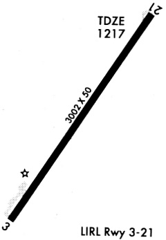
| Longest Runway: | 03/21 is 3002 ft (915 m) long |
| Runways with an Instrument Approach: |
KTVB Airport Runway Details
| Runway 03/21 | 3002 ft x 60 ft (915 m x 18 m) | |
| Runway Length Source: | 3RD PARTY SURVEY as of 05/22/2016 | |
| Surface: | Asphalt - Good condition - Aggregate friction seal coat | |
| Runway Edge Lights: | Medium Intensity | |
Runway Weight Bearing Capacity (in thousands of pounds) |
||
| Single Wheel Landing Gear: | 4.0 | |
Runway 03 |
Runway 21 |
|
Elevation: |
1219.9 | 1208.8 |
Latitude: |
37-07-44.2854N | 37-08-09.2363N |
Longitude: |
092-05-12.3266W | 092-04-52.2511W |
|
Runway True Alignment: |
033 | 213 |
Glide Path Angle: |
0.0 degrees | 0.0 degrees |
Traffic Pattern: |
Right | Left |
Runway Markings Type: |
Nonprecision Instrument | Nonprecision Instrument |
Runway Markings Condition: |
Good | Good |
Object at End: |
ROAD | TREES |
Object Height: |
15 | 30 |
Distance from End: |
300 | 215 |
Object Centerline Offset: |
250 ft. left and right of centerline | 210 ft. left of centerline |
Threshold Elevation: |
1219.7 | |
Displaced Threshold: |
190 | |
Threshold Latitude: |
37-07-45.8659N | |
Threshold Longitude: |
092-05-11.0547W |
Services
Airframe Repair: |
Minor |
Powerplant Repair: |
Minor |
Bottled Oxygen: |
None |
Fuel Available: |
100LL, Jet A+ |
Landing Fees: |
No |
Parking: |
Hangars and tiedowns available |
Maps & Diagrams
KTVB Sectional
Flight Planning
at skyvector.com
at skyvector.com