Location
Latitude: |
32-30-38.0910N (32.510581) |
Longitude: |
083-46-02.4450W (-83.767346) |
Elevation: |
418.2 feet MSL (127 m MSL) |
Magnetic Variation: |
5.8 W (as of April 2024 from WMM2020 model) |
Time Zone: |
UTC -5.0 (Standard Time) UTC -4.0 (Daylight Savings Time) |
From City: |
04 N.M. NW of Perry, Georgia |
Found On: |
Atlanta Chart |
FAA Region: |
ASO |
Contacts
Manager: |
Publicly owned: |
| JIM MARQUARDT 375 MYRTLE FIELD ROAD PERRY, GA 31069 478-988-3699 |
PERRY-HOUSTON CO ARPT AUTH 375 MYRTLE FIELD ROAD PERRY, GA 31069 478-988-3699 |
Operations
Airport Status: |
Operational |
Facility Use: |
Public |
Type: |
Airport |
Activation Date: |
05/1947 |
Control tower: |
No |
Attendance (Months/Days/Hours): |
Months/Days/Hours ALL/ALL/0800-1800 |
Boundary ARTCC: |
ZTL (Atlanta) |
Responsible ARTCC: |
ZTL (Atlanta) |
Lighting Schedule: |
SEE RMK |
Segmented Circle Indicator: |
Yes |
Traffic Pattern Altitude (MSL): |
1418 feet (432 m) |
NOTAMs Facility: |
MCN |
NOTAM-D Service: |
Yes |
International Airport of Entry: |
No |
Customs Landing Rights: |
No |
Military Landing Rights: |
Yes |
Civil/Military Joint Use: |
No |
Based Aircraft
| Single Engine: | 75 |
| Multi Engine: | 8 |
| Jet Engine: | 2 |
| GA Helicopters: | 3 |
Annual Operations (as of 12/31/2021)
| Total Operations: | 35000 | |
| GA Local: | 18550 | 53.0% |
| GA Itinerant: | 14700 | 42.0% |
| Military Aircraft: | 1750 | 5.0% |
Communications
| CTAF: | 122.725 |
| Unicom: | 122.725 |
| Approach: | ATLANTA 124.2 124.2 124.2 ATLANTA ARTCC |
| Departure: | ATLANTA 124.2 124.2 124.2 ATLANTA ARTCC |
| AWOS-3: | 123.825 (478-987-8768) |
- ATLANTA LARGE TRACON PROVIDES APCH/DEP SVC 0615-2300 ON FREQ 124.2; ATLANTA ARTCC PROVIDES APCH/DEP SVC 2300-0615 ON FREQ 134.5 (MACON RCAG).
Fixed Based Operators (FBOs) & Fuel
(Click on a business for detail)
Please help us keep this information up to date. This is a FREE SERVICE just like everything else on Airport Guide! If you see that a business needs to be added, modified, or deleted please fill out our Update Form.
To add, modify, or delete a business click here.
Please help us keep this information up to date. This is a FREE SERVICE just like everything else on Airport Guide! If you see that a business needs to be added, modified, or deleted please fill out our Update Form.
Area Code: 912 |
| Business Name | Frequency | Phone | Fuel Grade |
|---|---|---|---|
| Bay Creek Aviation, Inc.
Update FBO info |
Unicom 122.7 | 987-3713 | 100LL, Jet A |
Flight Service Stations
| Primary | Alternate | |
| FSS on Field: | N | |
| FSS Name (ID): | Macon(MCN) | |
| Frequency: | ||
| Toll Free Phone: | 1-800-WX-BRIEF |
Instrument Procedures / Charts
FAA Terminal Procedures valid from 0901Z 03/21/24 to 0901Z 04/18/24.
There are various types of charts available for an airport. They are listed in the Page Type column. Here is a legend for those types:
APD - Airport Diagram
DP - Departure Procedure Charts
HOT - Hot Spots
IAP - Instrument Approach Procedure Charts
MIN - Minimums
STAR - Standard Terminal Arrival Charts
| Page Type | Page Name | Volume | Action Since Last Cycle |
|---|---|---|---|
| IAP | ILS OR LOC RWY 36 | SE-4 | |
| IAP | RNAV (GPS) RWY 18 | SE-4 | |
| IAP | RNAV (GPS) RWY 36 | SE-4 | |
| MIN | ALTERNATE MINIMUMS | SE-4 | |
| MIN | TAKEOFF MINIMUMS | SE-4 |
Terminal Procedures are only available for airports in several countries with more being added all the time. If you are looking for a specific country's charts, please send an email to support(at)airportguide.com stating the country name. This will be used to prioritize the implementation.
Navigation Aids (Navaids) near KPXE
| Dist (NM) | ID | Morse Code | Name | Type | Freq | True Hdg | Mag Hdg |
|---|---|---|---|---|---|---|---|
| 3.2 | BEP | _ . . . . . _ _ . | Bay Creek | NDB | 350 | 178 | 184 |
| 11.9 | WRB | . _ _ . _ . _ . . . | Robins | TACAN | 135.30 | 48 | 54 |
| 12.4 | MCN | _ _ _ . _ . _ . | Macon | DME | 114.2 | 29 | 35 |
| 14.9 | IZS | . . _ _ . . . . . | Montezuma | NDB | 426 | 234 | 240 |
| 22.5 | VNA | . . . _ _ . . _ | Vienna | VORTAC | 116.50 | 142 | 148 |
| 26.6 | LKG | . _ . . _ . _ _ _ . | Lindbergh | NDB | 242 | 220 | 226 |
| 31.1 | OHY | _ _ _ . . . . _ . _ _ | Coney | NDB | 400 | 188 | 194 |
| 32.4 | OP | _ _ _ . _ _ . | Yates | NDB | 339 | 319 | 325 |
| 38.3 | DB | _ . . _ . . . | Creke | NDB | 251 | 92 | 98 |
| 38.5 | EZM | . _ _ . . _ _ | Eastman | NDB | 366 | 125 | 131 |
| 47.5 | DBN | _ . . _ . . . _ . | Dublin | VORTAC | 113.10 | 85 | 91 |
| 49.2 | UMB | . . _ _ _ _ . . . | Culvr | NDB | 380 | 38 | 44 |
| 51.3 | MQW | _ _ _ _ . _ . _ _ | Mc Rae | NDB | 280 | 118 | 124 |
| 51.7 | HIT | . . . . . . _ | Kaolin | NDB | 360 | 53 | 59 |
| 57.9 | PZD | . _ _ . _ _ . . _ . . | Pecan | VOR-DME | 116.10 | 207 | 213 |
| 59.1 | SUR | . . . . . _ . _ . | Fitzgerald | NDB | 362 | 155 | 161 |
| 59.3 | PIM | . _ _ . . . _ _ | Pine Mountain | NDB | 272 | 289 | 294 |
| 59.7 | FFC | . . _ . . . _ . _ . _ . | Pecat | NDB | 316 | 322 | 328 |
| 63.0 | LSF | . _ . . . . . . . _ . | Lawson | VOR-DME | 111.40 | 260 | 265 |
| 63.5 | CSG | _ . _ . . . . _ _ . | Columbus | TACAN | 117.10 | 276 | 281 |
Nearby Airports with Fuel
Notices to Airmen (NOTAMS)
Remarks
| A11 | BILL JERLES, CHAIRMAN AIRPORT AUTHORITY. |
| A110-1 | FOR CD CTC ATLANTA APCH AT 678-364-6132, WHEN APCH CLSD CTC ATLANTA ARTCC AT 770-210-7692. |
| A17 | CLSD THANKSGIVING, CHRISTMAS, NEW YEARS AND EASTER. |
| A17 1 | FOR SVC AFT HRS CALL 478-988-3699. |
| A81-APT | ACTVT MALSR RWY 36; PAPI RWY 18 & 36; HIRL RWY 18/36 - CTAF. |
Runways
Runway Summary
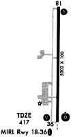
| Runways: | 18/36 |
| Longest Runway: | 18/36 is 5004 ft (1525 m) long |
| Runways with an Instrument Approach: | 36 |
KPXE Airport Runway Details
| Runway 18/36 | 5004 ft x 100 ft (1525 m x 30 m) | |
| Runway Length Source: | 3RD PARTY SURVEY as of 10/04/2022 | |
| Surface: | Asphalt - Good condition - No special surface treatment | |
| Runway Pavement Class: | 28 /F/A/X/T | |
| Runway Edge Lights: | High Intensity | |
Runway Weight Bearing Capacity (in thousands of pounds) |
||
| Single Wheel Landing Gear: | 40.0 | |
| Dual Wheel Landing Gear: | 91.0 | |
| Dual Tandem Wheel Landing Gear: | 145.0 | |
Runway 18 |
Runway 36 |
|
Elevation: |
418.0 | 410.8 |
Latitude: |
32-31-02.8456N | 32-30-13.3370N |
Longitude: |
083-46-02.7112W | 083-46-02.1780W |
|
Runway True Alignment: |
179 | 359 |
ILS Type: |
LOC/GS | |
Glide Path Angle: |
3.0 degrees | 3.0 degrees |
Traffic Pattern: |
Left | Left |
Runway Markings Type: |
Nonprecision Instrument | Precision Instrument |
Runway Markings Condition: |
Good | Good |
Visual Glide Slope Indicators: |
2-Light PAPI On Left Side Of Runway | 2-Light PAPI On Left Side Of Runway |
Approach Light System: |
1,400 Foot Medium Intensity Approach Lighting System With Runway Alignment Indicator Lights | |
REIL: |
No | |
Threshold Crossing Height: |
30 | 30 |
Services
Airframe Repair: |
Major |
Powerplant Repair: |
Major |
Bottled Oxygen: |
None |
Bulk Oxygen: |
None |
Fuel Available: |
100LL, Jet A, Jet A+ |
Landing Fees: |
No |
Parking: |
Tiedowns available |
Maps & Diagrams
KPXE Sectional
Flight Planning
at skyvector.com
at skyvector.com