Location
Latitude: |
33-49-42.5550N (33.828488) |
Longitude: |
079-07-19.8348W (-79.122176) |
Elevation: |
34.8 feet MSL (11 m MSL) |
Magnetic Variation: |
8.8 W (as of April 2024 from WMM2020 model) |
Time Zone: |
UTC -5.0 (Standard Time) UTC -4.0 (Daylight Savings Time) |
From City: |
03 N.M. W of Conway, South Carolina |
Found On: |
Charlotte Chart |
FAA Region: |
ASO |
Contacts
Manager: |
Publicly owned: |
| JUDI OLMSTEAD 1100 JETPORT RD MYRTLE BEACH, SC 29577 843-448-1580 |
HORRY COUNTY PO BOX 1236 CONWAY, SC 29526 843-397-9111 |
Operations
Airport Status: |
Operational |
Facility Use: |
Public |
Type: |
Airport |
Control tower: |
No |
Attendance (Months/Days/Hours): |
Months/Days/Hours ALL/ALL/0900-1700 |
Boundary ARTCC: |
ZJX (Jacksonville) |
Responsible ARTCC: |
ZJX (Jacksonville) |
Lighting Schedule: |
SEE RMK |
Segmented Circle Indicator: |
Yes |
Traffic Pattern Altitude (MSL): |
1035 feet (315 m) |
NOTAMs Facility: |
AND |
NOTAM-D Service: |
Yes |
International Airport of Entry: |
No |
Customs Landing Rights: |
No |
Military Landing Rights: |
Yes |
Civil/Military Joint Use: |
No |
Based Aircraft
| Single Engine: | 22 |
| Multi Engine: | 3 |
| Jet Engine: | 1 |
Annual Operations (as of 08/25/2021)
| Total Operations: | 12050 | |
| Air Taxi: | 301 | 2.5% |
| GA Local: | 6879 | 57.1% |
| GA Itinerant: | 4820 | 40.0% |
| Military Aircraft: | 50 | 0.4% |
Communications
| CTAF: | 122.700 |
| Unicom: | 122.700 |
| Approach: | MYRTLE BEACH 127.4 127.4 JAX ARTCC |
| Departure: | MYRTLE BEACH 127.4 127.4 JAX ARTCC |
| AWOS-3: | 119.525 (843-397-8046) |
- APCH/DEP SVC PRVDD BY JACKSONVILLE ARTCC ON FREQS 134.375/317.550 (MYRTLE BEACH RCAG) WHEN MYRTLE BEACH CTL CLSD.
Fixed Based Operators (FBOs) & Fuel
(Click on a business for detail)
Please help us keep this information up to date. This is a FREE SERVICE just like everything else on Airport Guide! If you see that a business needs to be added, modified, or deleted please fill out our Update Form.
To add, modify, or delete a business click here.
Please help us keep this information up to date. This is a FREE SERVICE just like everything else on Airport Guide! If you see that a business needs to be added, modified, or deleted please fill out our Update Form.
Area Code: 803 |
| Business Name | Frequency | Phone | Fuel Grade |
|---|---|---|---|
| North American Institute of Aviation
Update FBO info |
Unicom 122.7 | 626-3434, 397-9111 | 100LL |
Flight Service Stations
| Primary | Alternate | |
| FSS on Field: | N | |
| FSS Name (ID): | Anderson(AND) | |
| Frequency: | ||
| Toll Free Phone: | 1-800-WX-BRIEF |
Instrument Procedures / Charts
FAA Terminal Procedures valid from 0901Z 03/21/24 to 0901Z 04/18/24.
There are various types of charts available for an airport. They are listed in the Page Type column. Here is a legend for those types:
APD - Airport Diagram
DP - Departure Procedure Charts
HOT - Hot Spots
IAP - Instrument Approach Procedure Charts
MIN - Minimums
STAR - Standard Terminal Arrival Charts
| Page Type | Page Name | Volume | Action Since Last Cycle |
|---|---|---|---|
| IAP | RNAV (GPS) RWY 04 | SE-2 | |
| IAP | RNAV (GPS) RWY 22 | SE-2 | |
| MIN | ALTERNATE MINIMUMS | SE-2 | |
| MIN | TAKEOFF MINIMUMS | SE-2 |
Terminal Procedures are only available for airports in several countries with more being added all the time. If you are looking for a specific country's charts, please send an email to support(at)airportguide.com stating the country name. This will be used to prioritize the implementation.
Navigation Aids (Navaids) near KHYW
| Dist (NM) | ID | Morse Code | Name | Type | Freq | True Hdg | Mag Hdg |
|---|---|---|---|---|---|---|---|
| 0.4 | HYW | . . . . _ . _ _ . _ _ | Horry | NDB | 370 | 223 | 232 |
| 19.8 | CRE | _ . _ . . _ . . | Grand Strand | VORTAC | 114.40 | 92 | 101 |
| 21.0 | HEK | . . . . . _ . _ | Stuckey | NDB | 236 | 253 | 262 |
| 23.9 | MAO | _ _ . _ _ _ _ | Marion | NDB | 388 | 333 | 342 |
| 30.3 | PHH | . _ _ . . . . . . . . . | Andrews | NDB | 255 | 221 | 230 |
| 32.1 | CFY | _ . _ . . . _ . _ . _ _ | Evans | NDB | 420 | 273 | 282 |
| 32.4 | GGE | _ _ . _ _ . . | Georgetown | NDB | 242 | 198 | 207 |
| 33.6 | CPC | _ . _ . . _ _ . _ . _ . | Camp | NDB | 227 | 37 | 46 |
| 36.0 | FLO | . . _ . . _ . . _ _ _ | Florence | VORTAC | 115.20 | 312 | 321 |
| 37.1 | CKI | _ . _ . _ . _ . . | Kingstree | NDB | 404 | 259 | 268 |
| 39.3 | DLC | _ . . . _ . . _ . _ . | Dillon | NDB | 274 | 341 | 350 |
| 41.8 | FL | . . _ . . _ . . | Alcot | NDB | 335 | 299 | 308 |
| 43.0 | JB | . _ _ _ _ . . . | Jigel | NDB | 384 | 358 | 367 |
| 47.0 | LBT | . _ . . _ . . . _ | Lumberton | VOR | 110.00 | 3 | 12 |
| 47.3 | RSY | . _ . . . . _ . _ _ | Robeson | NDB | 359 | 3 | 12 |
| 51.7 | TGQ | _ _ _ . _ _ . _ | Elizabethtown | NDB | 398 | 35 | 44 |
| 53.0 | UDG | . . _ _ . . _ _ . | Darlington | NDB | 245 | 314 | 323 |
| 56.0 | MNI | _ _ _ . . . | Manning | NDB | 381 | 255 | 264 |
| 56.4 | BES | _ . . . . . . . | Bennettsville | NDB | 230 | 327 | 336 |
| 56.6 | ME | _ _ . | Maxtn | NDB | 257 | 343 | 352 |
Nearby Airports with Fuel
Notices to Airmen (NOTAMS)
Remarks
| A110-1 | FOR CD CTC MYRTLE BEACH APCH AT 843-477-2727 OR 843-477-2704, WHEN APCH CLSD CTC JACKSONVILLE ARTCC AT 904-845-1592. |
| A70-FUEL-10 | 0LL FUEL 24 HR CREDIT CARD SVC AVBL. |
| A81-APT | ACTVT MIRL RWY 04/22 - CTAF. |
Runways
Runway Summary
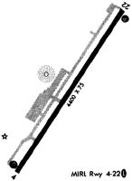
| Runways: | 04/22 |
| Longest Runway: | 04/22 is 4401 ft (1341 m) long |
| Runways with an Instrument Approach: |
KHYW Airport Runway Details
| Runway 04/22 | 4401 ft x 75 ft (1341 m x 23 m) | |
| Runway Length Source: | 3RD PARTY SURVEY as of 03/27/2008 | |
| Surface: | Asphalt - Good condition - No special surface treatment | |
| Runway Edge Lights: | Medium Intensity | |
Runway Weight Bearing Capacity (in thousands of pounds) |
||
| Single Wheel Landing Gear: | 12.5 | |
| Dual Wheel Landing Gear: | 20.0 | |
Runway 04 |
Runway 22 |
|
Elevation: |
33.3 | 34.5 |
Latitude: |
33-49-24.0586N | 33-50-01.0513N |
Longitude: |
079-07-33.5893W | 079-07-06.0802W |
|
Runway True Alignment: |
032 | 212 |
Glide Path Angle: |
3.4 degrees | 3.0 degrees |
Traffic Pattern: |
Left | Left |
Runway Markings Type: |
Nonprecision Instrument | Nonprecision Instrument |
Runway Markings Condition: |
Good | Good |
Object at End: |
TREE | TREE |
Object Height: |
85 | 76 |
Distance from End: |
1776 | 2013 |
Object Centerline Offset: |
220 ft. left of centerline | 449 ft. right of centerline |
Visual Glide Slope Indicators: |
4-Light PAPI On Right Side Of Runway | 4-Light PAPI On Left Side Of Runway |
REIL: |
Yes | Yes |
Threshold Crossing Height: |
48 | 43 |
Services
Airframe Repair: |
Minor |
Powerplant Repair: |
Minor |
Fuel Available: |
100LL, Jet A |
Landing Fees: |
No |
Parking: |
Tiedowns available |
Maps & Diagrams
KHYW Sectional
Flight Planning
at skyvector.com
at skyvector.com