Location
Latitude: |
42-43-53.0000N (42.731389) |
Longitude: |
095-33-21.8000W (-95.556056) |
Elevation: |
1226.4 feet MSL (374 m MSL) |
Magnetic Variation: |
1.8 E (as of April 2024 from WMM2020 model) |
Time Zone: |
UTC -6.0 (Standard Time) UTC -5.0 (Daylight Savings Time) |
From City: |
01 N.M. S of Cherokee, Iowa |
Found On: |
Omaha Chart |
FAA Region: |
ACE |
Contacts
Manager: |
Publicly owned: |
| SAVANNAH NELSON MUNI ARPT 1201 S 2ND ST CHEROKEE, IA 51012 712-225-2810 |
CITY OF CHEROKEE 1201 SOUTH 2ND STREET CHEROKEE, IA 51012 (712) 229-9365 |
Operations
Airport Status: |
Operational |
Facility Use: |
Public |
Type: |
Airport |
Activation Date: |
04/1940 |
Control tower: |
No |
Attendance (Months/Days/Hours): |
Months/Days/Hours ALL/MON-FRI/0800-1700 |
Boundary ARTCC: |
ZMP (Minneapolis) |
Responsible ARTCC: |
ZMP (Minneapolis) |
Lighting Schedule: |
SEE RMK |
Segmented Circle Indicator: |
No |
Traffic Pattern Altitude (MSL): |
2226 feet (678 m) |
NOTAMs Facility: |
CKP |
NOTAM-D Service: |
Yes |
International Airport of Entry: |
No |
Customs Landing Rights: |
No |
Military Landing Rights: |
Yes |
Civil/Military Joint Use: |
No |
Based Aircraft
| Single Engine: | 27 |
| Multi Engine: | 2 |
Annual Operations (as of 07/11/2023)
| Total Operations: | 5250 | |
| GA Local: | 2222 | 42.3% |
| GA Itinerant: | 3028 | 57.7% |
Communications
| CTAF: | 122.800 |
| Unicom: | 122.800 |
| AWOS-3: | 119.225 (712-225-1088) |
- APCH/DEP SVC PRVDD BY MINNEAPOLIS ARTCC ON FREQS 125.025/235.625 (SIOUX CITY RCAG).
Fixed Based Operators (FBOs) & Fuel
(Click on a business for detail)
Please help us keep this information up to date. This is a FREE SERVICE just like everything else on Airport Guide! If you see that a business needs to be added, modified, or deleted please fill out our Update Form.
To add, modify, or delete a business click here.
Please help us keep this information up to date. This is a FREE SERVICE just like everything else on Airport Guide! If you see that a business needs to be added, modified, or deleted please fill out our Update Form.
Area Code: 712 |
| Business Name | Frequency | Phone | Fuel Grade |
|---|---|---|---|
| Cherokee Aviation
Update FBO info |
Unicom 122.8 | 225-2810 | 100LL, Jet A |
Flight Service Stations
| Primary | Alternate | |
| FSS on Field: | N | |
| FSS Name (ID): | Fort Dodge(FOD) | |
| Frequency: | ||
| Toll Free Phone: | 1-800-WX-BRIEF |
Instrument Procedures / Charts
FAA Terminal Procedures valid from 0901Z 03/21/24 to 0901Z 04/18/24.
There are various types of charts available for an airport. They are listed in the Page Type column. Here is a legend for those types:
APD - Airport Diagram
DP - Departure Procedure Charts
HOT - Hot Spots
IAP - Instrument Approach Procedure Charts
MIN - Minimums
STAR - Standard Terminal Arrival Charts
| Page Type | Page Name | Volume | Action Since Last Cycle |
|---|---|---|---|
| IAP | RNAV (GPS) RWY 18 | NC-3 | |
| IAP | RNAV (GPS) RWY 36 | NC-3 | |
| MIN | ALTERNATE MINIMUMS | NC-3 | |
| MIN | TAKEOFF MINIMUMS | NC-3 |
Terminal Procedures are only available for airports in several countries with more being added all the time. If you are looking for a specific country's charts, please send an email to support(at)airportguide.com stating the country name. This will be used to prioritize the implementation.
Navigation Aids (Navaids) near KCKP
| Dist (NM) | ID | Morse Code | Name | Type | Freq | True Hdg | Mag Hdg |
|---|---|---|---|---|---|---|---|
| 15.8 | SLB | . . . . _ . . _ . . . | Storm Lake | NDB | 434 | 119 | 117 |
| 27.1 | ORC | _ _ _ . _ . _ . _ . | Orange City | NDB | 521 | 305 | 303 |
| 30.2 | LTU | . _ . . _ . . _ | Little Sioux | NDB | 326 | 37 | 35 |
| 30.2 | SPW | . . . . _ _ . . _ _ | Spencer | VOR-DME | 115.15 | 30 | 28 |
| 31.4 | SHL | . . . . . . . . _ . . | Sheldon | NDB | 338 | 337 | 335 |
| 31.8 | SP | . . . . _ _ . | Snore | NDB | 394 | 18 | 16 |
| 32.9 | SKI | . . . _ . _ . . | Sac City | NDB | 356 | 129 | 127 |
| 34.7 | MEY | _ _ . _ . _ _ | Mapleton | NDB | 335 | 197 | 195 |
| 36.8 | SOY | . . . _ _ _ _ . _ _ | Sioux Center | NDB | 368 | 311 | 309 |
| 39.2 | ISB | . . . . . _ . . . | Sibley | NDB | 269 | 347 | 345 |
| 40.0 | POH | . _ _ . _ _ _ . . . . | Pocahontas | NDB | 428 | 88 | 87 |
| 40.5 | SU | . . . . . _ | Salix | NDB | 414 | 233 | 231 |
| 41.1 | SUX | . . . . . _ _ . . _ | Sioux City | TACAN | 116.50 | 235 | 233 |
| 41.5 | GAK | _ _ . . _ _ . _ | Sioux Gateway | NDB | 233 | 242 | 240 |
| 43.2 | OI | _ _ _ . . | Tommi | NDB | 305 | 248 | 246 |
| 43.3 | EGQ | . _ _ . _ _ . _ | Emmetsburg | NDB | 410 | 58 | 57 |
| 45.5 | DNS | _ . . _ . . . . | Denison | NDB | 350 | 170 | 168 |
| 51.7 | PUF | . _ _ . . . _ . . _ . | Puff | NDB | 345 | 43 | 42 |
| 53.3 | OT | _ _ _ _ | Wondd | NDB | 277 | 4 | 2 |
| 54.0 | EST | . . . . _ | Estherville | VOR | 110.40 | 40 | 39 |
Nearby Airports with Fuel
Notices to Airmen (NOTAMS)
Remarks
| A110-1 | WATERFOWL ON & INVOF ARPT. |
| A110-2 | FOR CD CTC MINNEAPOLIS ARTCC AT 651-463-5588. |
| A17 | FOR ATTENDANT AFT HRS CALL 712-225-2810. |
| A30-01/19 | CLSD NOV-APR. |
| A42-01 | RY 01/19 THLDS & SIDES MARKED WITH YELLOW CONES. |
| A57-01 | APCH SLOPE 27:1 APCH SLOPE TO DSPLCD THLD. |
| A70-FUEL-10 | 0LL FOR FUEL AFT HRS CALL 712-225.2810. |
| A81-APT | ACTVT MIRL RY 18/36; REIL & PAPI RYS 18 & 36 - CTAF. |
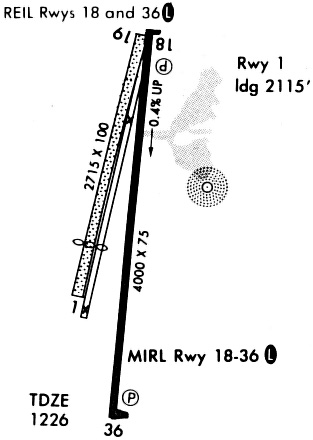
Runways
Runway Summary
| Runways: | 01/19 18/36 |
| Longest Runway: | 18/36 is 4001 ft (1220 m) long |
| Runways with an Instrument Approach: |
KCKP Airport Runway Details
| Runway 01/19 | 2621 ft x 100 ft (799 m x 30 m) | |
| Runway Length Source: | 3RD PARTY SURVEY as of 07/01/2014 | |
| Surface: | Turf - Fair condition - No special surface treatment | |
Runway 01 |
Runway 19 |
|
Elevation: |
1215.4 | 1213.8 |
Latitude: |
42-43-43.0833N | 42-44-08.5660N |
Longitude: |
095-33-27.0422W | 095-33-20.8410W |
|
Runway True Alignment: |
011 | 191 |
Glide Path Angle: |
0.0 degrees | 0.0 degrees |
Object at End: |
RR | TREES |
Object Height: |
29 | 51 |
Distance from End: |
211 | 1755 |
Object Centerline Offset: |
125 ft. left of centerline | 61 ft. left of centerline |
Threshold Elevation: |
1215.7 | |
Displaced Threshold: |
394 | |
Threshold Latitude: |
42-43-46.8708N | |
Threshold Longitude: |
095-33-26.1199W |
| Runway 18/36 | 4001 ft x 75 ft (1220 m x 23 m) | |
| Runway Length Source: | 3RD PARTY SURVEY as of 07/01/2014 | |
| Surface: | Turf - Fair condition - No special surface treatment | |
| Runway Pavement Class: | 9 /R/C/W/U | |
| Runway Edge Lights: | Medium Intensity | |
Runway Weight Bearing Capacity (in thousands of pounds) |
||
| Single Wheel Landing Gear: | 15.0 | |
Runway 18 |
Runway 36 |
|
Elevation: |
1211.8 | 1226.4 |
Latitude: |
42-44-10.8180N | 42-43-31.3462N |
Longitude: |
095-33-19.1003W | 095-33-21.6498W |
|
Runway True Alignment: |
183 | 003 |
Glide Path Angle: |
3.0 degrees | 3.6 degrees |
Traffic Pattern: |
Left | Left |
Runway Markings Type: |
Nonprecision Instrument | Nonprecision Instrument |
Runway Markings Condition: |
Good | Good |
Object at End: |
TREES | TREE |
Object Height: |
40 | 69 |
Distance from End: |
749 | 2189 |
Object Centerline Offset: |
125 ft. left of centerline | 61 ft. left of centerline |
Visual Glide Slope Indicators: |
2-Light PAPI On Left Side Of Runway | 2-Light PAPI On Right Side Of Runway |
REIL: |
Yes | Yes |
Threshold Crossing Height: |
41 | 39 |
Services
Airframe Repair: |
Major |
Powerplant Repair: |
Major |
Bottled Oxygen: |
None |
Bulk Oxygen: |
None |
Fuel Available: |
100LL |
Landing Fees: |
No |
Parking: |
Hangars and tiedowns available |
Maps & Diagrams
KCKP Sectional
Flight Planning
at skyvector.com
at skyvector.com