Location
Latitude: |
42-44-25.7000N (42.740472) |
Longitude: |
093-45-32.6000W (-93.759056) |
Elevation: |
1156.6 feet MSL (353 m MSL) |
Magnetic Variation: |
0.5 E (as of April 2024 from WMM2020 model) |
Time Zone: |
UTC -6.0 (Standard Time) UTC -5.0 (Daylight Savings Time) |
From City: |
01 N.M. NW of Clarion, Iowa |
Found On: |
Omaha Chart |
FAA Region: |
ACE |
Contacts
Manager: |
Publicly owned: |
| JON DEVRIES 2076 - 210TH STREET CLARION, IA 50525 515-532-6980 |
CITY OF CLARION 121 1ST ST. SW CLARION, IA 50525 515-851-0526 |
Operations
Airport Status: |
Operational |
Facility Use: |
Public |
Type: |
Airport |
Activation Date: |
12/1941 |
Control tower: |
No |
Attendance (Months/Days/Hours): |
Months/Days/Hours Unattended |
Boundary ARTCC: |
ZMP (Minneapolis) |
Responsible ARTCC: |
ZMP (Minneapolis) |
Lighting Schedule: |
SEE RMK |
Segmented Circle Indicator: |
No |
Traffic Pattern Altitude (MSL): |
2157 feet (657 m) |
NOTAMs Facility: |
CAV |
NOTAM-D Service: |
Yes |
International Airport of Entry: |
No |
Customs Landing Rights: |
No |
Military Landing Rights: |
Yes |
Civil/Military Joint Use: |
No |
Based Aircraft
| Single Engine: | 11 |
| Multi Engine: | 3 |
Annual Operations (as of 07/06/2023)
| Total Operations: | 3500 | |
| GA Local: | 1401 | 40.0% |
| GA Itinerant: | 2099 | 60.0% |
Communications
| CTAF: | 122.800 |
| Unicom: | 122.800 |
| AWOS-3: | 126.575 (515-532-3515) |
- APCH/DEP SVC PRVDD BY MINNEAPOLIS ARTCC ON FREQS 134.0/288.3 (FORT DODGE RCAG).
Fixed Based Operators (FBOs) & Fuel
(Click on a business for detail)
Please help us keep this information up to date. This is a FREE SERVICE just like everything else on Airport Guide! If you see that a business needs to be added, modified, or deleted please fill out our Update Form.
To add, modify, or delete a business click here.
Please help us keep this information up to date. This is a FREE SERVICE just like everything else on Airport Guide! If you see that a business needs to be added, modified, or deleted please fill out our Update Form.
Area Code: 515 |
| Business Name | Frequency | Phone | Fuel Grade |
|---|---|---|---|
| Clarion Municipal Airport
Update FBO info |
Unicom 122.8 | 532-6980 | 100LL |

|
Phillips | 100LL - 2.15 USD per gallon on 8/29/01 |
Pumps Sometimes fueling assistance is available, mainly self serve. |
Flight Service Stations
| Primary | Alternate | |
| FSS on Field: | N | |
| FSS Name (ID): | Fort Dodge(FOD) | |
| Frequency: | ||
| Toll Free Phone: | 1-800-WX-BRIEF |
Instrument Procedures / Charts
FAA Terminal Procedures valid from 0901Z 03/21/24 to 0901Z 04/18/24.
There are various types of charts available for an airport. They are listed in the Page Type column. Here is a legend for those types:
APD - Airport Diagram
DP - Departure Procedure Charts
HOT - Hot Spots
IAP - Instrument Approach Procedure Charts
MIN - Minimums
STAR - Standard Terminal Arrival Charts
| Page Type | Page Name | Volume | Action Since Last Cycle |
|---|---|---|---|
| IAP | RNAV (GPS) RWY 14 | NC-3 | |
| IAP | RNAV (GPS) RWY 32 | NC-3 | |
| MIN | ALTERNATE MINIMUMS | NC-3 | |
| MIN | TAKEOFF MINIMUMS | NC-3 |
Terminal Procedures are only available for airports in several countries with more being added all the time. If you are looking for a specific country's charts, please send an email to support(at)airportguide.com stating the country name. This will be used to prioritize the implementation.
Navigation Aids (Navaids) near KCAV
| Dist (NM) | ID | Morse Code | Name | Type | Freq | True Hdg | Mag Hdg |
|---|---|---|---|---|---|---|---|
| 0.3 | CAV | _ . _ . . _ . . . _ | Clarion | NDB | 387 | 352 | 352 |
| 18.6 | EBS | . _ . . . . . . | Webster City | NDB | 323 | 195 | 194 |
| 24.9 | FOD | . . _ . _ _ _ _ . . | Fort Dodge | TACAN | 113.50 | 251 | 250 |
| 26.6 | MC | _ _ _ . _ . | Surff | NDB | 348 | 45 | 45 |
| 27.7 | FO | . . _ . _ _ _ | Barro | NDB | 341 | 240 | 239 |
| 28.4 | MCW | _ _ _ . _ . . _ _ | Mason City | VOR-DME | 114.90 | 41 | 41 |
| 30.3 | FXY | . . _ . _ . . _ _ . _ _ | Forest City | NDB | 359 | 11 | 11 |
| 30.4 | AXA | . _ _ . . _ . _ | Algona | NDB | 403 | 312 | 311 |
| 39.2 | POH | . _ _ . _ _ _ . . . . | Pocahontas | NDB | 428 | 270 | 269 |
| 47.0 | EGQ | . _ _ . _ _ . _ | Emmetsburg | NDB | 410 | 297 | 296 |
| 50.4 | EE | . . | Merle | NDB | 362 | 174 | 174 |
| 50.7 | EFW | . . . _ . . _ _ | Jefferson | NDB | 391 | 210 | 209 |
| 51.1 | IY | . . _ . _ _ | Chukk | NDB | 417 | 62 | 62 |
| 53.3 | JWJ | . _ _ _ . _ _ . _ _ _ | Elmwood | DME | 109.4 | 134 | 134 |
| 53.5 | SBU | . . . _ . . . . . _ | Blue Earth | NDB | 332 | 344 | 343 |
| 54.3 | CCY | _ . _ . _ . _ . _ . _ _ | Charles City | NDB | 375 | 68 | 68 |
| 55.7 | FQ | . . _ . _ _ . _ | Montz | NDB | 420 | 334 | 333 |
| 56.4 | PUF | . _ _ . . . _ . . _ . | Puff | NDB | 345 | 310 | 309 |
| 58.2 | SKI | . . . _ . _ . . | Sac City | NDB | 356 | 248 | 247 |
| 59.0 | EST | . . . . _ | Estherville | VOR | 110.40 | 313 | 312 |
Nearby Airports with Fuel
Notices to Airmen (NOTAMS)
Remarks
| A110-1 | FOR CD CTC MINNEAPOLIS ARTCC AT 651-463-5588. |
| A81-APT | RY 14/32 MIRL PRESET LOW INTST; ACTVT PAPI & REIL RY 14 & 32 & MIRL RY 14/32 HIGHER INTST - CTAF |
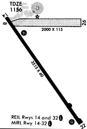
Runways
Runway Summary
| Runways: | 14/32 |
| Longest Runway: | 14/32 is 3455 ft (1053 m) long |
| Runways with an Instrument Approach: |
KCAV Airport Runway Details
| Runway 14/32 | 3455 ft x 60 ft (1053 m x 18 m) | |
| Runway Length Source: | 3RD PARTY SURVEY as of 06/21/2010 | |
| Surface: | Concrete - Good condition - No special surface treatment | |
| Runway Pavement Class: | 8 /R/D/W/U | |
| Runway Edge Lights: | Medium Intensity | |
Runway Weight Bearing Capacity (in thousands of pounds) |
||
| Single Wheel Landing Gear: | 17.0 | |
Runway 14 |
Runway 32 |
|
Elevation: |
1153.1 | 1156.6 |
Latitude: |
42-44-39.8092N | 42-44-11.6143N |
Longitude: |
093-45-45.6914W | 093-45-19.6093W |
|
Runway True Alignment: |
146 | 326 |
Glide Path Angle: |
3.0 degrees | 3.0 degrees |
Traffic Pattern: |
Left | Left |
Runway Markings Type: |
Nonprecision Instrument | Nonprecision Instrument |
Runway Markings Condition: |
Good | Good |
Object at End: |
ROAD | POLE |
Object Height: |
18 | 59 |
Distance from End: |
560 | 2210 |
Object Centerline Offset: |
280 ft. left of centerline | 0 ft. left and right of centerline |
Visual Glide Slope Indicators: |
2-Light PAPI On Left Side Of Runway | 2-Light PAPI On Left Side Of Runway |
REIL: |
Yes | Yes |
Threshold Crossing Height: |
40 | 43 |
Services
Airframe Repair: |
Minor |
Powerplant Repair: |
Minor |
Bottled Oxygen: |
None |
Bulk Oxygen: |
None |
Fuel Available: |
100LL |
Landing Fees: |
No |
Parking: |
Hangars and tiedowns available |
Maps & Diagrams
KCAV Sectional
Flight Planning
at skyvector.com
at skyvector.com