Location
Latitude: |
39-40-43.8491N (39.678847) |
Longitude: |
095-32-03.1630W (-95.534212) |
Elevation: |
1134.0 feet MSL (346 m MSL) |
Magnetic Variation: |
1.8 E (as of April 2024 from WMM2020 model) |
Time Zone: |
UTC -6.0 (Standard Time) UTC -5.0 (Daylight Savings Time) |
From City: |
01 N.M. NW of Horton, Kansas |
Found On: |
Kansas City Chart |
FAA Region: |
ACE |
Contacts
Manager: |
Publicly owned: |
| N. A. 202 E. 8TH STREET HORTON, KS 66439 785-486-2681 |
CITY OF HORTON PO BOX 30 HORTON, KS 66439 785-486-2681 |
Operations
Airport Status: |
Operational |
Facility Use: |
Public |
Type: |
Airport |
Activation Date: |
07/1949 |
Control tower: |
No |
Attendance (Months/Days/Hours): |
Months/Days/Hours Unattended |
Boundary ARTCC: |
ZKC (Kansas City) |
Responsible ARTCC: |
ZKC (Kansas City) |
Segmented Circle Indicator: |
Yes |
Traffic Pattern Altitude (MSL): |
2134 feet (650 m) |
NOTAMs Facility: |
ICT |
NOTAM-D Service: |
Yes |
International Airport of Entry: |
No |
Customs Landing Rights: |
No |
Civil/Military Joint Use: |
No |
Based Aircraft
Annual Operations (as of 08/31/2020)
| Total Operations: | 100 | |
| GA Itinerant: | 100 | 100.0% |
Communications
| CTAF: | 122.900 |
Fixed Based Operators (FBOs) & Fuel
(Click on a business for detail)
Please help us keep this information up to date. This is a FREE SERVICE just like everything else on Airport Guide! If you see that a business needs to be added, modified, or deleted please fill out our Update Form.
To add, modify, or delete a business click here.
Please help us keep this information up to date. This is a FREE SERVICE just like everything else on Airport Guide! If you see that a business needs to be added, modified, or deleted please fill out our Update Form.
Area Code: 785 |
| Business Name | Frequency | Phone | Fuel Grade |
|---|
Flight Service Stations
| Primary | Alternate | |
| FSS on Field: | N | |
| FSS Name (ID): | Wichita(ICT) | |
| Frequency: | ||
| Toll Free Phone: | 1-800-WX-BRIEF |
Instrument Procedures / Charts
Terminal Procedures are only available for airports in several countries with more being added all the time. If you are looking for a specific country's charts, please send an email to support(at)airportguide.com stating the country name. This will be used to prioritize the implementation.
Navigation Aids (Navaids) near K91
| Dist (NM) | ID | Morse Code | Name | Type | Freq | True Hdg | Mag Hdg |
|---|---|---|---|---|---|---|---|
| 11.5 | RBA | . _ . _ . . . . _ | Robinson | DME | 108.2 | 26 | 24 |
| 24.0 | FNB | . . _ . _ . _ . . . | Brenner | NDB | 404 | 354 | 352 |
| 29.0 | ST | . . . _ | Tario | NDB | 260 | 90 | 88 |
| 31.4 | AZN | . _ _ _ . . _ . | Amazon | NDB | 233 | 66 | 64 |
| 32.5 | TOP | _ _ _ _ . _ _ . | Topeka | VORTAC | 117.80 | 181 | 179 |
| 32.8 | STJ | . . . _ . _ _ _ | St Joseph | VORTAC | 115.50 | 58 | 56 |
| 34.2 | TO | _ _ _ _ | Biloy | NDB | 521 | 191 | 189 |
| 43.8 | MCI | _ _ _ . _ . . . | Kansas City | VORTAC | 113.25 | 122 | 120 |
| 44.0 | PWE | . _ _ . . _ _ . | Pawnee City | DME | 112.4 | 315 | 313 |
| 44.1 | FOE | . . _ . _ _ _ . | Forbes | VOT | 111.00 | 188 | 186 |
| 44.3 | FOE | . . _ . _ _ _ . | Forbes | TACAN | 111.60 | 187 | 185 |
| 45.6 | DO | _ . . _ _ _ | Dotte | NDB | 359 | 126 | 124 |
| 47.7 | FO | . . _ . _ _ _ | Riply | NDB | 326 | 182 | 180 |
| 49.2 | JZ | . _ _ _ _ _ . . | Newbn | NDB | 338 | 158 | 156 |
| 54.7 | MKC | _ _ _ . _ _ . _ . | Kansas City Downtown | VOT | 108.60 | 127 | 126 |
| 54.9 | RIS | . _ . . . . . . | Riverside | VOR-DME | 111.40 | 127 | 126 |
| 55.1 | GQ | _ _ . _ _ . _ | Norge | NDB | 517 | 132 | 131 |
| 57.6 | AFK | . _ . . _ . _ . _ | Nebraska City | NDB | 347 | 345 | 343 |
| 61.6 | MHK | _ _ . . . . _ . _ | Manhattan | VOR-DME | 110.20 | 239 | 237 |
| 62.5 | OJC | _ _ _ . _ _ _ _ . _ . | Johnson County | VOR-DME | 113.00 | 143 | 141 |
Nearby Airports with Fuel
Notices to Airmen (NOTAMS)
Remarks
| A110-2 | NO SNOW REMOVAL WINTER MONTHS. |
| A110-4 | NO PUBLIC PHONE OR FACILITIES AT ARPT. |
| A110-7 | +150 FT UNLGTD ANT ON WTR TWR 3684 FT SE OF AER 33. |
| A110-8 | TIEDOWN AREA & TWY UNMKD; MINIMAL MAINT; VERY ROUGH |
| A110-9 | FOR CD CTC ST JOSEPH APCH AT 816-236-3035. WHEN ST JOSEPH APCH IS CLSD, CTC KANSAS CITY ARTCC AT 913-254-8508. |
| A14 | JOHN CALHOON - CITY ADMINISTRATOR. |
| A17 | FOR ARPT ATTENDANT CALL 785-486-2681/2694. |
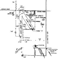
| A42-15 | 15/33 BOUNDARY MARKED BY 3 X 5 YELLOW CONC PADS. |
| A42-17 | 17/35 BOUNDARY MARKED BY 3 X 5 YELLOW CONC PADS. |
| A52-15 | +5 FENCE 212' FROM THLD. |
| A52-17 | +15 RD 35 FT FM AER 17. |
| A53-17 | FENCE OBSTN MKD WITH 4 X 4 YELLOW & BLACK STRIPED BOARD. |
| A53-33 | FENCE OBSTN MKD WITH YELLOW & BLACK STRIPED BOARD. |
| A53-35 | FENCE OBSTN MKD WITH 4 X 4 YELLOW & BLACK STRIPED BOARD. |
| E111 | BUILT PRIOR 1959. |
Runways
Runway Summary
| Runways: | 15/33 17/35 |
| Longest Runway: | 17/35 is 2223 ft (678 m) long |
| Runways with an Instrument Approach: |
K91 Airport Runway Details
| Runway 15/33 | 1636 ft x 100 ft (499 m x 30 m) | |
| Surface: | Turf - Good condition - No special surface treatment | |
Runway 15 |
Runway 33 |
|
Elevation: |
1130.0 | 1104.0 |
Latitude: |
39-40-51.5400N | 39-40-38.3300N |
Longitude: |
095-32-05.1900W | 095-31-53.1000W |
|
Runway True Alignment: |
145 | 325 |
Glide Path Angle: |
0.0 degrees | 0.0 degrees |
Traffic Pattern: |
Left | Left |
Object at End: |
ROAD | FENCE |
Object Height: |
15 | 3 |
Object Marked/Lighted?: |
Marked | |
Distance from End: |
305 | 35 |
Object Centerline Offset: |
0 ft. left and right of centerline | 0 ft. left and right of centerline |
| Runway 17/35 | 2223 ft x 100 ft (678 m x 30 m) | |
| Surface: | Turf - Good condition - No special surface treatment | |
Runway 17 |
Runway 35 |
|
Elevation: |
1113.0 | 1098.0 |
Latitude: |
39-40-54.0400N | 39-40-32.0600N |
Longitude: |
095-32-05.8800W | 095-32-06.3600W |
|
Runway True Alignment: |
181 | 001 |
Glide Path Angle: |
0.0 degrees | 0.0 degrees |
Traffic Pattern: |
Left | Left |
Object at End: |
FENCE | BRUSH |
Object Height: |
6 | 9 |
Object Marked/Lighted?: |
Marked | |
Distance from End: |
15 | 35 |
Object Centerline Offset: |
0 ft. left and right of centerline | 0 ft. left and right of centerline |
Services
Powerplant Repair: |
Major |
Fuel Available: |
100LL, MOGAS |
Landing Fees: |
No |
Parking: |
Tiedowns available |
Maps & Diagrams
K91 Sectional
Flight Planning
at skyvector.com
at skyvector.com