Location
Latitude: |
39-38-03.8790N (39.634411) |
Longitude: |
091-43-37.1800W (-91.726994) |
Elevation: |
737.1 feet MSL (225 m MSL) |
Magnetic Variation: |
0.9 W (as of April 2024 from WMM2020 model) |
Time Zone: |
UTC -6.0 (Standard Time) UTC -5.0 (Daylight Savings Time) |
From City: |
01 N.M. S of Monroe City, Missouri |
Found On: |
Kansas City Chart |
FAA Region: |
ACE |
Contacts
Manager: |
Publicly owned: |
| DELL BUCKMAN 109 2ND ST., BOX 67 MONROE CITY, MO 63456 573-231-9521 |
CITY OF MONROE 109 2ND ST., BOX 67 MONROE CITY, MO 63456 573-735-4845 |
Operations
Airport Status: |
Operational |
Facility Use: |
Public |
Type: |
Airport |
Control tower: |
No |
Attendance (Months/Days/Hours): |
Months/Days/Hours ALL/MON-FRI/0800-1700 |
Boundary ARTCC: |
ZKC (Kansas City) |
Responsible ARTCC: |
ZKC (Kansas City) |
Lighting Schedule: |
SEE RMK |
Segmented Circle Indicator: |
Yes |
Traffic Pattern Altitude (MSL): |
1737 feet (529 m) |
NOTAMs Facility: |
STL |
NOTAM-D Service: |
Yes |
International Airport of Entry: |
No |
Customs Landing Rights: |
No |
Military Landing Rights: |
No |
Civil/Military Joint Use: |
No |
Based Aircraft
| Single Engine: | 2 |
Annual Operations (as of 12/31/2019)
| Total Operations: | 2060 | |
| Air Taxi: | 50 | 2.4% |
| GA Local: | 1000 | 48.5% |
| GA Itinerant: | 1000 | 48.5% |
| Military Aircraft: | 10 | 0.5% |
Communications
| CTAF: | 122.800 |
| Unicom: | 122.800 |
- APCH/DEP SVC PRVDD BY KANSAS CITY ARTCC ON FREQS 126.225/317.775 (QUINCY RCAG).
Fixed Based Operators (FBOs) & Fuel
(Click on a business for detail)
Please help us keep this information up to date. This is a FREE SERVICE just like everything else on Airport Guide! If you see that a business needs to be added, modified, or deleted please fill out our Update Form.
To add, modify, or delete a business click here.
Please help us keep this information up to date. This is a FREE SERVICE just like everything else on Airport Guide! If you see that a business needs to be added, modified, or deleted please fill out our Update Form.
Area Code: 573 |
| Business Name | Frequency | Phone | Fuel Grade |
|---|---|---|---|
| City of Monroe
Update FBO info |
Unicom 122.8 | 735-4845 | 100LL, MOGAS |
Flight Service Stations
| Primary | Alternate | |
| FSS on Field: | N | |
| FSS Name (ID): | Saint Louis(STL) | |
| Frequency: | ||
| Toll Free Phone: | 1-800-WX-BRIEF |
Instrument Procedures / Charts
FAA Terminal Procedures valid from 0901Z 03/21/24 to 0901Z 04/18/24.
There are various types of charts available for an airport. They are listed in the Page Type column. Here is a legend for those types:
APD - Airport Diagram
DP - Departure Procedure Charts
HOT - Hot Spots
IAP - Instrument Approach Procedure Charts
MIN - Minimums
STAR - Standard Terminal Arrival Charts
| Page Type | Page Name | Volume | Action Since Last Cycle |
|---|---|---|---|
| IAP | RNAV (GPS) RWY 09 | NC-3 | |
| IAP | RNAV (GPS) RWY 27 | NC-3 | |
| MIN | TAKEOFF MINIMUMS | NC-3 |
Terminal Procedures are only available for airports in several countries with more being added all the time. If you are looking for a specific country's charts, please send an email to support(at)airportguide.com stating the country name. This will be used to prioritize the implementation.
Navigation Aids (Navaids) near K52
| Dist (NM) | ID | Morse Code | Name | Type | Freq | True Hdg | Mag Hdg |
|---|---|---|---|---|---|---|---|
| 24.3 | UIN | . . _ . . _ . | Quincy | TACAN | 113.60 | 58 | 59 |
| 26.6 | UI | . . _ . . | Quincy | NDB | 293 | 55 | 56 |
| 34.9 | MCM | _ _ _ . _ . _ _ | Macon | DME | 112.9 | 272 | 273 |
| 36.4 | HLV | . . . . . _ . . . . . _ | Hallsville | VORTAC | 114.20 | 210 | 211 |
| 49.9 | IRK | . . . _ . _ . _ | Kirksville | VORTAC | 114.60 | 307 | 308 |
| 51.6 | EOK | . _ _ _ _ . _ | Keokuk | NDB | 366 | 15 | 16 |
| 54.4 | COU | _ . _ . _ _ _ . . _ | Columbia | VOR-DME | 110.20 | 204 | 205 |
| 64.3 | BZK | _ . . . _ _ . . _ . _ | Brookfield | NDB | 383 | 277 | 277 |
| 65.6 | JEF | . _ _ _ . . . _ . | Jefferson City | VOT | 112.00 | 198 | 199 |
| 66.5 | FTZ | . . _ . _ _ _ . . | Foristell | VORTAC | 110.80 | 147 | 148 |
| 67.1 | JE | . _ _ _ . | Algoa | NDB | 397 | 193 | 194 |
| 67.2 | BR | _ . . . . _ . | Burns | NDB | 390 | 24 | 25 |
| 69.2 | IJX | . . . _ _ _ _ . . _ | Jacksonville | DME | 108.6 | 82 | 83 |
| 74.0 | BEX | _ . . . . _ . . _ | Bloomfield | NDB | 269 | 334 | 335 |
| 74.2 | STL | . . . _ . _ . . | St Louis | VORTAC | 117.40 | 128 | 129 |
| 74.6 | SU | . . . . . _ | Snoop | NDB | 326 | 142 | 143 |
| 75.0 | BRL | _ . . . . _ . . _ . . | Burlington | VOR-DME | 111.40 | 29 | 30 |
| 75.4 | JZY | . _ _ _ _ _ . . _ . _ _ | Macomb | NDB | 251 | 44 | 45 |
| 76.8 | LM | . _ . . _ _ | Oblio | NDB | 338 | 130 | 131 |
| 76.8 | SUS | . . . . . _ . . . | Spirit Of St Louis | VOT | 112.20 | 139 | 140 |
Nearby Airports with Fuel
Notices to Airmen (NOTAMS)
Remarks
| A110*G | THIS AIRPORT HAS BEEN SURVEYED BY THE NATIONAL GEODETIC SURVEY. |
| A110-1 | FOR CD CTC KANSAS CITY ARTCC AT 913-254-8508. |
| A16 | AIRPORT OFFICE PHONE (573) 735-4845. |
| A58-09 | +1-4' FENCE 0-200' FM RY END 120'R. |
| A58-27 | 1-5 FT FENCE 65-200 FT FM RY END & 120 FT R; 1-5 FT FENCE 0-200 FT FM RY END & 125 FT L. |
| A81-APT | DUSK-DAWN. MIRL RY 09/27 PRESET LOW INTST; TO INCR INTST & ACTVT PAPI RYS 09 & 27 - CTAF. |
| E147 | TPA LIGHT ACFT 800 FT AGL, TURBO PROP AND JETS 1500 FT AGL |
Runways
Runway Summary
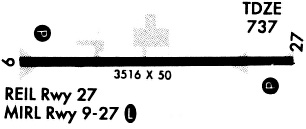
| Runways: | 09/27 |
| Longest Runway: | 09/27 is 3515 ft (1071 m) long |
| Runways with an Instrument Approach: |
K52 Airport Runway Details
| Runway 09/27 | 3515 ft x 50 ft (1071 m x 15 m) | |
| Surface: | Asphalt - Good condition - No special surface treatment | |
| Runway Edge Lights: | Medium Intensity | |
Runway Weight Bearing Capacity (in thousands of pounds) |
||
| Single Wheel Landing Gear: | 16.0 | |
Runway 09 |
Runway 27 |
|
Elevation: |
736.6 | 734.2 |
Latitude: |
39-38-04.4560N | 39-38-03.3010N |
Longitude: |
091-43-59.6360W | 091-43-14.7240W |
|
Runway True Alignment: |
092 | 272 |
Glide Path Angle: |
3.0 degrees | 3.0 degrees |
Traffic Pattern: |
Left | Left |
Runway Markings Type: |
Nonprecision Instrument | Nonprecision Instrument |
Runway Markings Condition: |
Good | Good |
Object at End: |
POLE | TREES |
Object Height: |
20 | 21 |
Distance from End: |
495 | 425 |
Object Centerline Offset: |
145 ft. right of centerline | 125 ft. right of centerline |
Visual Glide Slope Indicators: |
2-Light PAPI On Left Side Of Runway | 2-Light PAPI On Left Side Of Runway |
Threshold Crossing Height: |
38 | 39 |
Services
Airframe Repair: |
Major |
Powerplant Repair: |
Major |
Bottled Oxygen: |
None |
Bulk Oxygen: |
None |
Fuel Available: |
100LL, Jet A |
Landing Fees: |
No |
Parking: |
Hangars and tiedowns available |
Maps & Diagrams
K52 Sectional
Flight Planning
at skyvector.com
at skyvector.com