Location
Latitude: |
37-15-55.4802N (37.265411) |
Longitude: |
098-32-52.4612W (-98.547906) |
Elevation: |
1549.0 feet MSL (472 m MSL) |
Magnetic Variation: |
3.8 E (as of April 2024 from WMM2020 model) |
Time Zone: |
UTC -6.0 (Standard Time) UTC -5.0 (Daylight Savings Time) |
From City: |
03 N.M. SE of Medicine Lodge, Kansas |
Found On: |
Wichita Chart |
FAA Region: |
ACE |
Contacts
Manager: |
Publicly owned: |
| JEFF PORTER 114 W 1ST ST. MEDICINE LODGE, KS 67104 620-886-3908 |
MEDICINE LODGE 114 W. 1ST STREET MEDICINE LODGE, KS 67104 620-886-3908 |
Operations
Airport Status: |
Operational |
Facility Use: |
Public |
Type: |
Airport |
Activation Date: |
10/1945 |
Control tower: |
No |
Attendance (Months/Days/Hours): |
Months/Days/Hours Unattended |
Boundary ARTCC: |
ZKC (Kansas City) |
Responsible ARTCC: |
ZKC (Kansas City) |
Lighting Schedule: |
SS-SR |
Segmented Circle Indicator: |
No |
Traffic Pattern Altitude (MSL): |
2549 feet (777 m) |
NOTAMs Facility: |
ICT |
NOTAM-D Service: |
Yes |
Civil/Military Joint Use: |
No |
Based Aircraft
Annual Operations (as of 06/26/2020)
| Total Operations: | 2400 | |
| GA Local: | 1200 | 50.0% |
| GA Itinerant: | 1200 | 50.0% |
Communications
| CTAF: | 122.900 |
| AWOS-2: | 119.625 (620-886-3290) |
Fixed Based Operators (FBOs) & Fuel
(Click on a business for detail)
Please help us keep this information up to date. This is a FREE SERVICE just like everything else on Airport Guide! If you see that a business needs to be added, modified, or deleted please fill out our Update Form.
To add, modify, or delete a business click here.
Please help us keep this information up to date. This is a FREE SERVICE just like everything else on Airport Guide! If you see that a business needs to be added, modified, or deleted please fill out our Update Form.
Area Code: 620 |
| Business Name | Frequency | Phone | Fuel Grade |
|---|
Flight Service Stations
| Primary | Alternate | |
| FSS on Field: | N | |
| FSS Name (ID): | Wichita(ICT) | |
| Frequency: | ||
| Toll Free Phone: | 1-800-WX-BRIEF |
Instrument Procedures / Charts
Terminal Procedures are only available for airports in several countries with more being added all the time. If you are looking for a specific country's charts, please send an email to support(at)airportguide.com stating the country name. This will be used to prioritize the implementation.
Navigation Aids (Navaids) near K51
| Dist (NM) | ID | Morse Code | Name | Type | Freq | True Hdg | Mag Hdg |
|---|---|---|---|---|---|---|---|
| 19.1 | ANY | . _ _ . _ . _ _ | Anthony | TACAN | 112.90 | 109 | 105 |
| 29.2 | PTT | . _ _ . _ _ | Pratt | NDB | 356 | 341 | 337 |
| 52.7 | HUT | . . . . . . _ _ | Hutchinson | VOR-DME | 116.80 | 33 | 29 |
| 54.2 | ICT | . . _ . _ . _ | Wichita | VORTAC | 113.80 | 57 | 54 |
| 55.3 | IC | . . _ . _ . | Piche | NDB | 332 | 69 | 66 |
| 55.4 | EGT | . _ _ . _ | Wellington | NDB | 414 | 86 | 83 |
| 56.1 | MDF | _ _ _ . . . . _ . | Mooreland | NDB | 284 | 213 | 209 |
| 56.7 | BFK | _ . . . . . _ . _ . _ | Buffalo | NDB | 215 | 245 | 241 |
| 57.6 | ICT | . . _ . _ . _ | Wichita | VOT | 114.00 | 66 | 63 |
| 59.3 | HU | . . . . . . _ | Saltt | NDB | 404 | 29 | 25 |
| 60.9 | GB | _ _ . _ . . . | Babsy | NDB | 419 | 346 | 342 |
| 61.9 | LQR | . _ . . _ _ . _ . _ . | Larned | NDB | 296 | 335 | 331 |
| 63.0 | END | . _ . _ . . | Vance | VORTAC | 115.40 | 151 | 147 |
| 64.6 | IAB | . . . _ _ . . . | Mc Connell | TACAN | 116.50 | 70 | 67 |
| 64.8 | ODG | _ _ _ _ . . _ _ . | Woodring | VOR-DME | 109.00 | 145 | 141 |
| 66.6 | LYO | . _ . . _ . _ _ _ _ _ | Lyons | NDB | 386 | 13 | 9 |
| 67.7 | HIL | . . . . . . . _ . . | Hilyn | NDB | 338 | 345 | 341 |
| 69.7 | EI | . . . | Garfy | NDB | 341 | 148 | 144 |
| 73.0 | SO | . . . _ _ _ | Sawcy | NDB | 353 | 97 | 94 |
| 73.4 | PER | . _ _ . . . _ . | Pioneer | VORTAC | 113.20 | 114 | 111 |
Nearby Airports with Fuel
Notices to Airmen (NOTAMS)
Remarks
| A110-1 | AWOS 398 FT. LEFT RY 16 |
| A110-2 | FOR CD CTC KANSAS CITY ARTCC AT 913-254-8508. |
| A110-3 | 25' WIDE BY 430' LONG ASPH TWY 140' SOUTH OF THE AER 16. TO A 80' X 145' APRON |
| A17 | FOR SERVICE & ARPT INFO CALL SHERIFF 620-886-5678. |
| A58-34 | 5 FT FENCE 160 FT FROM RY END. |
| E111 | EXISTED PRIOR TO 1959. |
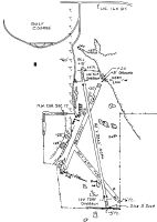
Runways
Runway Summary
| Runways: | 13/31 16/34 |
| Longest Runway: | 16/34 is 3200 ft (975 m) long |
| Runways with an Instrument Approach: |
K51 Airport Runway Details
| Runway 13/31 | 1690 ft x 80 ft (515 m x 24 m) | |
| Surface: | Turf - Good condition - No special surface treatment | |
Runway 13 |
Runway 31 |
|
Elevation: |
1522.0 | 1511.0 |
Latitude: |
37-15-57.2800N | 37-15-43.5700N |
Longitude: |
098-32-57.8800W | 098-32-45.9300W |
|
Runway True Alignment: |
145 | 325 |
Glide Path Angle: |
0.0 degrees | 0.0 degrees |
Object at End: |
FENCE | |
Object Height: |
6 | |
Distance from End: |
0 | |
Object Centerline Offset: |
0 ft. left and right of centerline |
| Runway 16/34 | 3200 ft x 42 ft (975 m x 13 m) | |
| Surface: | Turf - Good condition - No special surface treatment | |
| Runway Edge Lights: | Low Intensity | |
Runway 16 |
Runway 34 |
|
Elevation: |
1549.0 | 1508.0 |
Latitude: |
37-16-13.8800N | 37-15-42.4200N |
Longitude: |
098-32-54.8600W | 098-32-50.6500W |
|
Runway True Alignment: |
174 | 354 |
Glide Path Angle: |
0.0 degrees | 0.0 degrees |
Traffic Pattern: |
Left | Left |
Runway Markings Type: |
Basic | Basic |
Runway Markings Condition: |
Good | Good |
Object at End: |
TREE | |
Object Height: |
40 | |
Distance from End: |
745 | |
Object Centerline Offset: |
0 ft. left and right of centerline | |
Displaced Threshold: |
200 | |
Threshold Latitude: |
37-15-44.3800N | |
Threshold Longitude: |
098-32-50.9300W | |
Declared Distances |
||
Take Off Run Avbl. (TORA): |
3200 | 3200 |
Take Off Distance Avbl. (TODA): |
3200 | 3200 |
Services
Airframe Repair: |
None |
Powerplant Repair: |
None |
Bottled Oxygen: |
None |
Bulk Oxygen: |
None |
Fuel Available: |
100LL, MOGAS |
Landing Fees: |
No |
Parking: |
Tiedowns available |
Maps & Diagrams
K51 Sectional
Flight Planning
at skyvector.com
at skyvector.com