Location
Latitude: |
39-40-43.3550N (39.67871) |
Longitude: |
075-36-23.8860W (-75.606635) |
Elevation: |
79.9 feet MSL (24 m MSL) |
Magnetic Variation: |
11.6 W (as of April 2024 from WMM2020 model) |
Time Zone: |
UTC -5.0 (Standard Time) UTC -4.0 (Daylight Savings Time) |
From City: |
04 N.M. S of Wilmington, Delaware |
Found On: |
Washington Chart |
FAA Region: |
AEA |
Contacts
Manager: |
Publicly owned: |
| BENJAMIN CLENDANIEL 151 N. DUPONT HIGHWAY NEW CASTLE, DE 19720-0071 (302) 229-6315 |
DELAWARE RIVER & BAY AUTHORITY 151 N. DUPONT HIGHWAY NEW CASTLE, DE 19720-0071 (302) 571-6445 |
Operations
Airport Status: |
Operational |
Facility Use: |
Public |
Type: |
Airport |
Activation Date: |
05/1943 |
Control tower: |
Yes |
Attendance (Months/Days/Hours): |
Months/Days/Hours ALL/ALL/ALL |
Boundary ARTCC: |
ZDC (Washington) |
Responsible ARTCC: |
ZNY (New York) |
Lighting Schedule: |
SEE RMK |
Segmented Circle Indicator: |
No |
Traffic Pattern Altitude (MSL): |
1080 feet (329 m) |
NOTAMs Facility: |
ILG |
NOTAM-D Service: |
Yes |
International Airport of Entry: |
No |
Customs Landing Rights: |
Yes |
Military Landing Rights: |
Yes |
Civil/Military Joint Use: |
No |
Aircraft Rescue and Firefighting: |
Class I ARFF Index: B Air Carrier Service: Scheduled Certification Date: 05/1973 |
Based Aircraft
| Single Engine: | 94 |
| Multi Engine: | 26 |
| Jet Engine: | 74 |
| GA Helicopters: | 5 |
| Military Aircraft: | 20 |
Annual Operations (as of 12/22/2022)
| Total Operations: | 46057 | |
| Commercial: | 105 | 0.2% |
| Air Taxi: | 3538 | 7.7% |
| GA Local: | 22962 | 49.9% |
| GA Itinerant: | 13871 | 30.1% |
| Military Aircraft: | 5581 | 12.1% |
Communications
| CTAF: | 126.000 |
| Unicom: | 122.950 |
| Tower: | WILMINGTON 126.0 352.05 Hrs: 0630-2300 |
| Clearance Del.: | 119.95 |
| Ground: | 121.7 275.8 |
| Approach: | PHILADELPHIA |
| Departure: | PHILADELPHIA |
| ATIS: | 123.95 Hrs: 24 |
| ASOS: | 123.95 (302-328-1536) |
| EMERG: | 121.5 |
| EMERG: | 243.0 |
| ARNG OPS: | 46.9FM |
- CLEARANCE DELIVERY PHILADELPHIA APCH TF 800-354-9884.
Fixed Based Operators (FBOs) & Fuel
(Click on a business for detail)
Please help us keep this information up to date. This is a FREE SERVICE just like everything else on Airport Guide! If you see that a business needs to be added, modified, or deleted please fill out our Update Form.
To add, modify, or delete a business click here.
Please help us keep this information up to date. This is a FREE SERVICE just like everything else on Airport Guide! If you see that a business needs to be added, modified, or deleted please fill out our Update Form.
Area Code: 302 |
| Business Name | Frequency | Phone | Fuel Grade |
|---|---|---|---|
| Aero Taxi
Website Update FBO info |
328-3430, 800-551-8555 | 100LL, Jet A | |
| Dassault Falcon Jet
Website Update FBO info |
Unicom 122.95 | 322-7363, 800-441-9390 | 100LL, Jet A |
| Delaware Skyways
Update FBO info |
328-8090 | ||
| FBO AvCenter
Website Update FBO info |
Unicom 122.95 | 328-9695 | 100LL, Jet A |

|
 Avfuel |
100LL - 2.88 USD per gallon on 10/1/01 |
24 Hour Self Serve Credit Card Pumps |
|
|
Avfuel |
Jet A - 2.73 USD per gallon on 10/1/01 |
24 Hour Self Serve Credit Card Pumps |
| FlightSafety International
Website Update FBO info |
328-7548, 800-733-7548 | ||
| Hangar 6 Aero Service
Update FBO info |
Unicom 123.3 | 325-2703 | |
| J Harris Aviation
Update FBO info |
521-9924, 838-0533 |
Flight Service Stations
| Primary | Alternate | |
| FSS on Field: | N | |
| FSS Name (ID): | Millville(MIV) | |
| Frequency: | ||
| Toll Free Phone: | 1-800-WX-BRIEF |
Instrument Procedures / Charts
FAA Terminal Procedures valid from 0901Z 03/21/24 to 0901Z 04/18/24.
There are various types of charts available for an airport. They are listed in the Page Type column. Here is a legend for those types:
APD - Airport Diagram
DP - Departure Procedure Charts
HOT - Hot Spots
IAP - Instrument Approach Procedure Charts
MIN - Minimums
STAR - Standard Terminal Arrival Charts
| Page Type | Page Name | Volume | Action Since Last Cycle |
|---|---|---|---|
| APD | AIRPORT DIAGRAM | NE-3 | |
| HOT | HOT SPOT | NE-3 | |
| IAP | ILS OR LOC RWY 01 | NE-3 | |
| IAP | RNAV (GPS) RWY 01 | NE-3 | |
| IAP | RNAV (GPS) RWY 09 | NE-3 | |
| IAP | RNAV (GPS) RWY 19 | NE-3 | |
| IAP | RNAV (GPS) RWY 27 | NE-3 | |
| IAP | VOR RWY 09 | NE-3 | |
| IAP | VOR RWY 27 | NE-3 | |
| LAH | LAHSO | NE-3 | |
| MIN | ALTERNATE MINIMUMS | NE-3 | |
| MIN | TAKEOFF MINIMUMS | NE-3 | |
| STAR | ARLFT TWO (RNAV) | NE-3 | |
| STAR | BUNTS THREE | NE-3 | |
| STAR | CEDAR LAKE NINE | NE-3 | |
| STAR | JIIMS FOUR (RNAV) | NE-3 |
Terminal Procedures are only available for airports in several countries with more being added all the time. If you are looking for a specific country's charts, please send an email to support(at)airportguide.com stating the country name. This will be used to prioritize the implementation.
Navigation Aids (Navaids) near ILG
| Dist (NM) | ID | Morse Code | Name | Type | Freq | True Hdg | Mag Hdg |
|---|---|---|---|---|---|---|---|
| 0.0 | DQO | _ . . _ _ . _ _ _ _ | Dupont | VORTAC | 114.00 | 210 | 222 |
| 5.9 | IL | . . . _ . . | Hadin | NDB | 248 | 183 | 195 |
| 14.3 | OOD | _ _ _ _ _ _ _ . . | Woodstown | VORTAC | 112.80 | 100 | 112 |
| 14.7 | MXE | _ _ _ . . _ . | Modena | VORTAC | 113.20 | 348 | 360 |
| 20.5 | PHL | . _ _ . . . . . . _ . . | Philadelphia | VOT | 109.80 | 56 | 68 |
| 24.6 | APG | . _ . _ _ . _ _ . | Aberdeen | NDB | 349 | 249 | 261 |
| 26.8 | RNB | . _ . _ . _ . . . | Rainbow | NDB | 363 | 125 | 137 |
| 27.2 | ENO | . _ . _ _ _ | Smyrna | VORTAC | 111.40 | 171 | 183 |
| 29.0 | PPM | . _ _ . . _ _ . _ _ | Phillips | VOR-DME | 108.40 | 244 | 255 |
| 30.6 | ING | . . _ . _ _ . | Ambler | NDB | 275 | 28 | 40 |
| 30.7 | VCN | . . . _ _ . _ . _ . | Cedar Lake | VOR-DME | 115.20 | 105 | 117 |
| 32.7 | PTW | . _ _ . _ . _ _ | Pottstown | VORTAC | 116.50 | 3 | 15 |
| 33.4 | DOV | _ . . _ _ _ . . . _ | Dover | TACAN | 110.00 | 168 | 180 |
| 36.6 | PNE | . _ _ . _ . . | North Philadelphia | VOR | 112.00 | 48 | 60 |
| 41.2 | LRP | . _ . . . _ . . _ _ . | Lancaster | VOR-DME | 117.30 | 310 | 322 |
| 47.0 | UKT | . . _ _ . _ _ | Quakertown | NDB | 208 | 17 | 29 |
| 47.1 | ARD | . _ . _ . _ . . | Yardley | VOR-DME | 108.20 | 42 | 54 |
| 49.5 | ACY | . _ _ . _ . _ . _ _ | Atlantic City | VORTAC | 108.60 | 105 | 117 |
| 50.6 | GXU | _ _ . _ . . _ . . _ | Mc Guire | VORTAC | 110.60 | 66 | 78 |
| 51.2 | SIE | . . . . . . | Sea Isle | VORTAC | 114.80 | 132 | 144 |
Nearby Airports with Fuel
Notices to Airmen (NOTAMS)
Remarks
| A11 | LEASEE. PROPERTY OWNED BY NEW CASTLE COUNTY 87 READS WAY NEW CASTLE, DE 19720. TEL 302-395-5990. |
| A110-1 | RWY 14/32 CLSD TO SKED AIR CARRIER OPS WITH MORE THAN 9 PAX SEATS AND NON SKED AIR CARRIER OPS WITH MORE THAN 30 PAX SEATS EXC FOR TAXI |
| A110-11 | WHEN ATCT CLSD, PILOTS MUST ANNOUNCE INTENTIONS OVER CTAF BEFORE LDGS; TKOFS OR GND TRAVEL ON RYS & TWYS. |
| A110-12 | PVT GND VEHICLES CROSS TWY A BTN TWYS A4 & C. |
| A110-14 | WHEN ATCT CLSD ANNOUNCE EMERGENCIES ON CTAF DIRECTLY TO ARFF STATION. |
| A110-15 | MILITARY: ANG: EXPECT INCR BIRD ACT (INCL WATERFOWL) DUR BASH PHASE II (MAR-MAY & SEP-NOV). CTC CASTLE OPS FOR CURRENT BIRD WATCH COND. |
| A110-16 | TERMINAL APRON CLSD EXCEPT AIR CARRIER. |
| A110-18 | ARNG - OPR 1200-2130Z++ WKD (OPEN ADDN HR FOR SKED TRNG), CLSD SAT, SUN AND HOL. PPR ONLY DSN 440-7205, C302-326-7205. LTD TRAN MAINT, SVC, PRK. CTC GRIFFIN OPS 46.90 10 MIN OUT. |
| A110-2 | BIRDS ON & INVOF ARPT. |
| A110-20 | FOR CD WHEN ATCT IS CLSD CTC PHL APCH AT (800) 354-9884. |
| A110-21 | TRML APRON FENCE LINE 118 FT E OF TWY A CNTRLN. |
| A110-22 | RWY 01 5000 FT DIST RMNG SIGN MISG. |
| A110-24 | RWY 27 5000 FT DIST RMNG SIGN MISG. |
| A110-25 | RWY 09 2000 FT DIST RMNG SIGN MISG. |
| A110-3 | RWY 09/27 NO TGL FOR TURBO JET 2300-0700. |
| A110-4 | TAXILANE 'G' NORTHWEST OF TWY 'H' LTD TO ACFT WITH WINGSPAN OF 79 FT OR LESS. TAXILANE 'G' SECTION BTW TWY 'H' & TWY 'G1' LTD TO ACFT WITH WINGSPAN OF 49 FT OR LESS. |
| A24 | LNDG FEE FOR ALL ACFT OVER 7500 LBS EXCEPT FEDERAL GOVT; MILITARY. |
| A40-14/32 | RWY 14/32 NON-STANDARD MILITARY ASSAULT LANDING ZONE (ALZ) LIGHTING. |
| A81-APT | WHEN TWR CLSD ACTVT MALSR RWY 01; REIL RWY 09, 27 & 19; PAPI RWY 09 & 27; HIRL RWY 01/19 & 09/27; MIRL RWY 14/32 - CTAF. |
| E60-19 | ENGINEERED MATERIAL ARRESTING SYSTEM (EMAS) 303 FT IN LENGTH BY 170 FT IN WIDTH LCTD AT DER 19. |
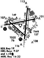
Runways
Runway Summary
| Runways: | 01/19 09/27 14/32 |
| Longest Runway: | 09/27 is 7275 ft (2217 m) long |
| Runways with an Instrument Approach: | 01 |
ILG Airport Runway Details
| Runway 01/19 | 7012 ft x 150 ft (2137 m x 46 m) | |
| Runway Length Source: | 3RD PARTY SURVEY as of 03/18/2022 | |
| Surface: | Asphalt - Fair condition - Saw-cut or plastic grooved | |
| Runway Pavement Class: | 66 /F/A/W/T | |
| Runway Edge Lights: | High Intensity | |
Runway Weight Bearing Capacity (in thousands of pounds) |
||
| Single Wheel Landing Gear: | 120.0 | |
| Dual Wheel Landing Gear: | 250.0 | |
| Dual Tandem Wheel Landing Gear: | 550.0 | |
| Dual Dual Tandem Wheel Landing Gear: | 1056.0 | |
Runway 01 |
Runway 19 |
|
Elevation: |
74.9 | 61.0 |
Latitude: |
39-40-09.4509N | 39-41-18.4754N |
Longitude: |
075-36-13.7634W | 075-36-05.8288W |
|
Runway True Alignment: |
005 | 185 |
ILS Type: |
ILS | |
Glide Path Angle: |
0.0 degrees | 3.0 degrees |
Traffic Pattern: |
Left | Left |
Runway Markings Type: |
Precision Instrument | Nonprecision Instrument |
Runway Markings Condition: |
Good | Good |
Arresting Device: |
EMAS | |
Object at End: |
ROAD | TREES |
Object Height: |
8 | 72 |
Distance from End: |
500 | 1240 |
Object Centerline Offset: |
0 ft. left and right of centerline | 500 ft. left of centerline |
Visual Glide Slope Indicators: |
4-Light PAPI On Left Side Of Runway | |
Runway Visual Range (RVR): |
Touchdown | Rollout |
Approach Light System: |
1,400 Foot Medium Intensity Approach Lighting System With Runway Alignment Indicator Lights | |
REIL: |
Yes | |
Threshold Crossing Height: |
55 | |
Declared Distances |
||
Take Off Run Avbl. (TORA): |
7012 | 7012 |
Take Off Distance Avbl. (TODA): |
7012 | 7012 |
Actual Stop Dist. Avbl. (ASDA): |
7012 | 7012 |
Landing Dist. Avbl. (LDA): |
7012 | 7012 |
| Runway 09/27 | 7275 ft x 150 ft (2217 m x 46 m) | |
| Runway Length Source: | 3RD PARTY SURVEY as of 03/18/2022 | |
| Surface: | Asphalt - Fair condition - Saw-cut or plastic grooved | |
| Runway Pavement Class: | 64 /F/A/W/T | |
| Runway Edge Lights: | High Intensity | |
Runway Weight Bearing Capacity (in thousands of pounds) |
||
| Single Wheel Landing Gear: | 120.0 | |
| Dual Wheel Landing Gear: | 250.0 | |
| Dual Tandem Wheel Landing Gear: | 524.0 | |
| Dual Dual Tandem Wheel Landing Gear: | 1034.0 | |
Runway 09 |
Runway 27 |
|
Elevation: |
79.8 | 71.3 |
Latitude: |
39-40-41.0335N | 39-40-56.2963N |
Longitude: |
075-37-14.1124W | 075-35-43.1879W |
|
Runway True Alignment: |
078 | 258 |
Glide Path Angle: |
3.0 degrees | 3.0 degrees |
Traffic Pattern: |
Left | Left |
Runway Markings Type: |
Precision Instrument | Nonprecision Instrument |
Runway Markings Condition: |
Good | Good |
Object at End: |
TREES | TREES |
Object Height: |
49 | 64 |
Distance from End: |
1125 | 1000 |
Object Centerline Offset: |
0 ft. left and right of centerline | 500 ft. left of centerline |
Visual Glide Slope Indicators: |
4-Light PAPI On Left Side Of Runway | 4-Light PAPI On Left Side Of Runway |
REIL: |
Yes | Yes |
Threshold Crossing Height: |
61 | 54 |
Declared Distances |
||
Take Off Run Avbl. (TORA): |
7275 | 7275 |
Take Off Distance Avbl. (TODA): |
7275 | 7275 |
Actual Stop Dist. Avbl. (ASDA): |
7000 | 7000 |
Landing Dist. Avbl. (LDA): |
7000 | 7000 |
| Runway 14/32 | 4602 ft x 150 ft (1403 m x 46 m) | |
| Runway Length Source: | 3RD PARTY SURVEY as of 03/18/2022 | |
| Surface: | Asphalt - Fair condition - No special surface treatment | |
| Runway Pavement Class: | 43 /F/A/X/T | |
| Runway Edge Lights: | Medium Intensity | |
Runway Weight Bearing Capacity (in thousands of pounds) |
||
| Single Wheel Landing Gear: | 111.0 | |
| Dual Wheel Landing Gear: | 181.0 | |
| Dual Tandem Wheel Landing Gear: | 328.0 | |
| Dual Dual Tandem Wheel Landing Gear: | 763.0 | |
Runway 14 |
Runway 32 |
|
Elevation: |
75.2 | 74.2 |
Latitude: |
39-40-48.8973N | 39-40-19.1575N |
Longitude: |
075-37-00.0848W | 075-36-15.5560W |
|
Runway True Alignment: |
131 | 311 |
Glide Path Angle: |
0.0 degrees | 3.0 degrees |
Traffic Pattern: |
Left | Left |
Runway Markings Type: |
Basic | Basic |
Runway Markings Condition: |
Good | Good |
Object at End: |
TREES | |
Object Height: |
43 | |
Distance from End: |
720 | |
Object Centerline Offset: |
0 ft. left and right of centerline | 500 ft. left of centerline |
Visual Glide Slope Indicators: |
4-Box VASI On Left Side Of Runway | |
Threshold Crossing Height: |
28 | |
Declared Distances |
||
Take Off Run Avbl. (TORA): |
4602 | 4602 |
Take Off Distance Avbl. (TODA): |
4602 | 4602 |
Actual Stop Dist. Avbl. (ASDA): |
4602 | 4602 |
Landing Dist. Avbl. (LDA): |
4602 | 4602 |
Services
Airframe Repair: |
Major |
Powerplant Repair: |
Major |
Bottled Oxygen: |
None |
Bulk Oxygen: |
None |
Fuel Available: |
100LL |
Landing Fees: |
No |
Parking: |
Tiedowns available |
Maps & Diagrams
ILG Sectional
Flight Planning
at skyvector.com
at skyvector.com