Location
Latitude: |
40-43-19.9000N (40.722194) |
Longitude: |
095-01-35.8000W (-95.026611) |
Elevation: |
995.8 feet MSL (304 m MSL) |
Magnetic Variation: |
1.5 E (as of April 2024 from WMM2020 model) |
Time Zone: |
UTC -6.0 (Standard Time) UTC -5.0 (Daylight Savings Time) |
From City: |
01 N.M. SE of Clarinda, Iowa |
Found On: |
Omaha Chart |
FAA Region: |
ACE |
Contacts
Manager: |
Publicly owned: |
| MILO BEERY 3042 - 210TH STREET CLARINDA, IA 51632 712-542-3010 |
CITY OF CLARINDA P.O. BOX 339 CLARINDA, IA 51632 712-542-2136 |
Operations
Airport Status: |
Operational |
Facility Use: |
Public |
Type: |
Airport |
Activation Date: |
01/1950 |
Control tower: |
No |
Attendance (Months/Days/Hours): |
Months/Days/Hours ALL/ALL/0800-1700 |
Boundary ARTCC: |
ZMP (Minneapolis) |
Responsible ARTCC: |
ZMP (Minneapolis) |
Lighting Schedule: |
SEE RMK |
Segmented Circle Indicator: |
Yes |
Traffic Pattern Altitude (MSL): |
1996 feet (608 m) |
NOTAMs Facility: |
ICL |
NOTAM-D Service: |
Yes |
International Airport of Entry: |
No |
Customs Landing Rights: |
No |
Military Landing Rights: |
Yes |
Civil/Military Joint Use: |
No |
Based Aircraft
| Single Engine: | 19 |
Annual Operations (as of 06/07/2022)
| Total Operations: | 5500 | |
| GA Local: | 2750 | 50.0% |
| GA Itinerant: | 2750 | 50.0% |
Communications
| CTAF: | 122.800 |
| Unicom: | 122.800 |
| AWOS-3: | 132.025 (712-542-3345) |
- APCH/DEP SVC PRVDD BY MINNEAPOLIS ARTCC ON FREQS 119.6/290.4 (OMAHA RCAG).
Fixed Based Operators (FBOs) & Fuel
(Click on a business for detail)
Please help us keep this information up to date. This is a FREE SERVICE just like everything else on Airport Guide! If you see that a business needs to be added, modified, or deleted please fill out our Update Form.
To add, modify, or delete a business click here.
Please help us keep this information up to date. This is a FREE SERVICE just like everything else on Airport Guide! If you see that a business needs to be added, modified, or deleted please fill out our Update Form.
Area Code: 712 |
| Business Name | Frequency | Phone | Fuel Grade |
|---|
Flight Service Stations
| Primary | Alternate | |
| FSS on Field: | N | |
| FSS Name (ID): | Fort Dodge(FOD) | |
| Frequency: | ||
| Toll Free Phone: | 1-800-WX-BRIEF |
Instrument Procedures / Charts
FAA Terminal Procedures valid from 0901Z 03/21/24 to 0901Z 04/18/24.
There are various types of charts available for an airport. They are listed in the Page Type column. Here is a legend for those types:
APD - Airport Diagram
DP - Departure Procedure Charts
HOT - Hot Spots
IAP - Instrument Approach Procedure Charts
MIN - Minimums
STAR - Standard Terminal Arrival Charts
| Page Type | Page Name | Volume | Action Since Last Cycle |
|---|---|---|---|
| IAP | RNAV (GPS) RWY 02 | NC-3 | |
| IAP | RNAV (GPS) RWY 20 | NC-3 | |
| MIN | ALTERNATE MINIMUMS | NC-3 | |
| MIN | TAKEOFF MINIMUMS | NC-3 |
Terminal Procedures are only available for airports in several countries with more being added all the time. If you are looking for a specific country's charts, please send an email to support(at)airportguide.com stating the country name. This will be used to prioritize the implementation.
Navigation Aids (Navaids) near ICL
| Dist (NM) | ID | Morse Code | Name | Type | Freq | True Hdg | Mag Hdg |
|---|---|---|---|---|---|---|---|
| 0.1 | ICL | . . _ . _ . . _ . . | Clarinda | NDB | 353 | 325 | 324 |
| 17.4 | SDA | . . . _ . . . _ | Shenandoah | NDB | 411 | 275 | 273 |
| 20.4 | RDK | . _ . _ . . _ . _ | Red Oak | NDB | 230 | 329 | 327 |
| 20.5 | CRZ | _ . _ . . _ . _ _ . . | Corning | NDB | 278 | 36 | 35 |
| 33.9 | UNE | . . _ _ . . | Union County | NDB | 379 | 65 | 64 |
| 38.6 | AFK | . _ . . _ . _ . _ | Nebraska City | NDB | 347 | 259 | 257 |
| 40.9 | AIO | . _ . . _ _ _ | Atlantic | NDB | 365 | 358 | 357 |
| 41.8 | OVR | _ _ _ . . . _ . _ . | Omaha | VORTAC | 116.30 | 309 | 307 |
| 42.4 | PMV | . _ _ . _ _ . . . _ | Plattsmouth | NDB | 329 | 288 | 286 |
| 45.9 | STJ | . . . _ . _ _ _ | St Joseph | VORTAC | 115.50 | 174 | 173 |
| 46.1 | OFF | _ _ _ . . _ . . . _ . | Offutt | TACAN | 111.70 | 301 | 299 |
| 46.4 | FNB | . . _ . _ . _ . . . | Brenner | NDB | 404 | 213 | 211 |
| 46.6 | EN | . _ . | Rikky | NDB | 426 | 310 | 308 |
| 48.8 | LMN | . _ . . _ _ _ . | Lamoni | VOR-DME | 116.70 | 98 | 97 |
| 50.6 | AZN | . _ _ _ . . _ . | Amazon | NDB | 233 | 173 | 172 |
| 52.0 | OMA | _ _ _ _ _ . _ | Omaha | VOT | 109.00 | 311 | 309 |
| 53.3 | HNR | . . . . _ . . _ . | Harlan | NDB | 272 | 344 | 342 |
| 55.3 | RBA | . _ . _ . . . . _ | Robinson | DME | 108.2 | 199 | 197 |
| 56.9 | MLE | _ _ . _ . . . | Millard | NDB | 371 | 300 | 298 |
| 57.1 | OM | _ _ _ _ _ | Gerfi | NDB | 320 | 312 | 310 |
Nearby Airports with Fuel
Notices to Airmen (NOTAMS)
Remarks
| A11 | GARY MC CLARNON, CITY MGR, 712-542-2136. |
| A110-1 | FOR CD CTC MINNEAPOLIS ARTCC AT 651-463-5588. |
| A42-13 | MKD WITH YELLOW CONES. |
| A42-31 | MKD WITH YELLOW CONES. |
| A81-APT | ACTVT MIRL RY 02/20; REIL RY 20 AND PAPI RY 02 & 20 - CTAF. |
| E111 | PROVIDED APCH TO EACH RWY IS MAINTAINED FOR A MINIMUM 20:1 GLIDE SLOPE AND TRANSITIONAL SURFACE BE MAINTAINED FOR A 7:1 SLOPE. |
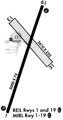
Runways
Runway Summary
| Runways: | 02/20 13/31 |
| Longest Runway: | 02/20 is 5000 ft (1524 m) long |
| Runways with an Instrument Approach: |
ICL Airport Runway Details
| Runway 02/20 | 5000 ft x 75 ft (1524 m x 23 m) | |
| Runway Length Source: | 3RD PARTY SURVEY as of 06/27/2012 | |
| Surface: | Concrete - Good condition - No special surface treatment | |
| Runway Pavement Class: | 7 /R/B/W/T | |
| Runway Edge Lights: | Medium Intensity | |
Runway Weight Bearing Capacity (in thousands of pounds) |
||
| Single Wheel Landing Gear: | 12.0 | |
Runway 02 |
Runway 20 |
|
Elevation: |
990.7 | 995.1 |
Latitude: |
40-42-54.6354N | 40-43-39.6361N |
Longitude: |
095-01-50.1184W | 095-01-23.3246W |
|
Runway True Alignment: |
024 | 204 |
Glide Path Angle: |
3.0 degrees | 3.0 degrees |
Traffic Pattern: |
Left | Left |
Runway Markings Type: |
Nonprecision Instrument | Nonprecision Instrument |
Runway Markings Condition: |
Good | Good |
Object at End: |
ROAD | BLDG |
Object Height: |
13 | 99 |
Distance from End: |
475 | 2570 |
Object Centerline Offset: |
280 ft. right of centerline | 155 ft. left of centerline |
Visual Glide Slope Indicators: |
2-Light PAPI On Left Side Of Runway | 2-Light PAPI On Left Side Of Runway |
REIL: |
No | Yes |
Threshold Crossing Height: |
28 | 30 |
| Runway 13/31 | 2729 ft x 280 ft (832 m x 85 m) | |
| Runway Length Source: | 3RD PARTY SURVEY as of 06/27/2012 | |
| Surface: | Concrete - Good condition - No special surface treatment | |
Runway 13 |
Runway 31 |
|
Elevation: |
995.8 | 982.6 |
Latitude: |
40-43-35.3690N | 40-43-14.2973N |
Longitude: |
095-01-45.1367W | 095-01-23.0209W |
|
Runway True Alignment: |
141 | 321 |
Glide Path Angle: |
0.0 degrees | 0.0 degrees |
Traffic Pattern: |
Left | Left |
Object at End: |
TREES | |
Object Height: |
32 | |
Distance from End: |
420 | |
Object Centerline Offset: |
280 ft. right of centerline | 155 ft. left of centerline |
Services
Airframe Repair: |
None |
Powerplant Repair: |
None |
Bottled Oxygen: |
None |
Bulk Oxygen: |
None |
Fuel Available: |
100LL, Jet A |
Landing Fees: |
No |
Parking: |
Hangars and tiedowns available |
Maps & Diagrams
ICL Sectional
Flight Planning
at skyvector.com
at skyvector.com