Location
Latitude: |
37-36-01.6000N (37.600444) |
Longitude: |
081-33-33.4000W (-81.559278) |
Elevation: |
1783.0 feet MSL (543 m MSL) |
Magnetic Variation: |
7.8 W (as of April 2024 from WMM2020 model) |
Time Zone: |
UTC -5.0 (Standard Time) UTC -4.0 (Daylight Savings Time) |
From City: |
02 N.M. NW of Pineville, West Virginia |
Found On: |
Cincinnati Chart |
FAA Region: |
AEA |
Contacts
Manager: |
Publicly owned: |
| BILLY JOE COOPER PO BOX 309 PINEVILLE, WV 24874 304-732-9160 |
WYOMING CO COMM. COURTHOUSE PINEVILLE, WV 24874 304-732-8000 |
Operations
Airport Status: |
Operational |
Facility Use: |
Public |
Type: |
Airport |
Activation Date: |
10/1969 |
Control tower: |
No |
Attendance (Months/Days/Hours): |
Months/Days/Hours ALL/MON-FRI/0900-1600 |
Boundary ARTCC: |
ZID (Indianapolis) |
Responsible ARTCC: |
ZID (Indianapolis) |
Lighting Schedule: |
SEE RMK |
Segmented Circle Indicator: |
Yes |
Traffic Pattern Altitude (MSL): |
2783 feet (848 m) |
NOTAMs Facility: |
EKN |
NOTAM-D Service: |
Yes |
International Airport of Entry: |
No |
Customs Landing Rights: |
No |
Military Landing Rights: |
Yes |
Civil/Military Joint Use: |
No |
Based Aircraft
| Single Engine: | 4 |
Annual Operations (as of 07/10/2023)
| Total Operations: | 2200 | |
| GA Local: | 2000 | 90.9% |
| GA Itinerant: | 200 | 9.1% |
Communications
| CTAF: | 122.800 |
| Unicom: | 122.800 |
| Approach: | CHARLESTON 125.4 125.4 |
| Departure: | CHARLESTON 125.4 125.4 |
| AWOS-3: | 120.625 (304-732-7311) |
Fixed Based Operators (FBOs) & Fuel
(Click on a business for detail)
Please help us keep this information up to date. This is a FREE SERVICE just like everything else on Airport Guide! If you see that a business needs to be added, modified, or deleted please fill out our Update Form.
To add, modify, or delete a business click here.
Please help us keep this information up to date. This is a FREE SERVICE just like everything else on Airport Guide! If you see that a business needs to be added, modified, or deleted please fill out our Update Form.
Area Code: 304 |
| Business Name | Frequency | Phone | Fuel Grade |
|---|---|---|---|
| Wyoming County-Kee Field
Update FBO info |
732-9160, after hours call 732-7372 | 100LL |
Flight Service Stations
| Primary | Alternate | |
| FSS on Field: | N | |
| FSS Name (ID): | Elkins(EKN) | |
| Frequency: | ||
| Toll Free Phone: | 1-800-WX-BRIEF |
Instrument Procedures / Charts
FAA Terminal Procedures valid from 0901Z 03/21/24 to 0901Z 04/18/24.
There are various types of charts available for an airport. They are listed in the Page Type column. Here is a legend for those types:
APD - Airport Diagram
DP - Departure Procedure Charts
HOT - Hot Spots
IAP - Instrument Approach Procedure Charts
MIN - Minimums
STAR - Standard Terminal Arrival Charts
| Page Type | Page Name | Volume | Action Since Last Cycle |
|---|---|---|---|
| IAP | RNAV (GPS) RWY 08 | NE-4 | |
| IAP | RNAV (GPS) RWY 26 | NE-4 | |
| MIN | TAKEOFF MINIMUMS | NE-4 |
Terminal Procedures are only available for airports in several countries with more being added all the time. If you are looking for a specific country's charts, please send an email to support(at)airportguide.com stating the country name. This will be used to prioritize the implementation.
Navigation Aids (Navaids) near I16
| Dist (NM) | ID | Morse Code | Name | Type | Freq | True Hdg | Mag Hdg |
|---|---|---|---|---|---|---|---|
| 19.9 | GTC | _ _ . _ _ . _ . | Guyandot | NDB | 293 | 303 | 311 |
| 23.3 | BKW | _ . . . _ . _ . _ _ | Beckley | VOR-DME | 117.70 | 62 | 70 |
| 24.8 | BLF | _ . . . . _ . . . . _ . | Bluefield | VOR-DME | 115.05 | 135 | 143 |
| 42.2 | RNL | . _ . _ . . _ . . | Rainelle | VOR | 116.60 | 57 | 65 |
| 43.5 | MKJ | _ _ _ . _ . _ _ _ | Suzze | NDB | 335 | 159 | 167 |
| 46.0 | HVQ | . . . . . . . _ _ _ . _ | Charleston | VOR-DME | 117.40 | 347 | 355 |
| 46.4 | CRW | _ . _ . . _ . . _ _ | Charleston | VOT | 108.80 | 358 | 366 |
| 50.8 | PSK | . _ _ . . . . _ . _ | Pulaski | VORTAC | 116.80 | 127 | 135 |
| 52.7 | GZG | _ _ . _ _ . . _ _ . | Glade Spring | VOR-DME | 110.20 | 208 | 216 |
| 52.9 | LW | . _ . . . _ _ | Bushi | NDB | 346 | 77 | 85 |
| 55.2 | VJ | . . . _ . _ _ _ | Whine | NDB | 236 | 199 | 207 |
| 57.6 | LWB | . _ . . . _ _ _ . . . | Greenbrier | DME | 116.05 | 73 | 81 |
| 59.9 | TEC | _ . _ . _ . | Tech | NDB | 368 | 112 | 120 |
| 61.4 | HLX | . . . . . _ . . _ . . _ | Hillsville | NDB | 269 | 144 | 152 |
| 70.9 | JUH | . _ _ _ . . _ . . . . | Ashee | NDB | 410 | 170 | 178 |
| 72.2 | ECB | . _ . _ . _ . . . | Newcombe | DME | 110.4 | 298 | 305 |
| 72.5 | TR | _ . _ . | Mocca | NDB | 299 | 210 | 218 |
| 72.6 | ROA | . _ . _ _ _ . _ | Roanoke | VOR-DME | 109.40 | 101 | 109 |
| 72.6 | HNN | . . . . _ . _ . | Henderson | DME | 115.9 | 342 | 350 |
| 75.0 | HMV | . . . . _ _ . . . _ | Holston Mountain | VORTAC | 114.60 | 201 | 209 |
Nearby Airports with Fuel
Notices to Airmen (NOTAMS)
Remarks
| A110*G | THIS AIRPORT HAS BEEN SURVEYED BY THE NATIONAL GEODETIC SURVEY. |
| A110-2 | WILDLIFE ON AND INVOF ARPT. |
| A110-3 | LANDFILL MIDPT OF RWY, SOUTH SIDE. BIRDS ON AND INVOF ARPT. |
| A110-4 | RISING TERRAIN SURROUNDS ARPT. |
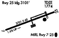
| A110-5 | RY SLOPES DOWN 2% FROM E TO W. |
| A110-6 | FOR CD CTC INDIANAPOLIS ARTCC AT 317-247-2411. |
| A17 | UNATND MAJ. HOL. FOR ARPT ATTENDANT AFTER HRS CALL 304-732-7372 (MGR RES). |
| A57-26 | APCH SLOPE 3:1 AT DTHR; OVR 30 FT TREES 105 FT DSTC, 125 FT RIGHT. |
| A58-08 | 25 FT GND UP TO 200 FT OUT, 120 FT LEFT; 40 FT TREES 0 FT DSTC, 120 FT RIGHT. |
| A58-26 | RISING GND 4 FT, 75 TO 200 FT DSTC, ACROSS THLD. 30 FT TREES, 0 FT DSTC, 7 FT LEFT & RIGHT. |
| A75 | PILOT PROVIDE OWN ROPES. |
| A80 | ARPT BCN LCTD 3000' NE ARPT. |
| A81-APT | ACTVT MIRL RY 08/26, REIL RYS 08/26 - CTAF. |
Runways
Runway Summary
| Runways: | 08/26 |
| Longest Runway: | 08/26 is 3701 ft (1128 m) long |
| Runways with an Instrument Approach: |
I16 Airport Runway Details
| Runway 08/26 | 3701 ft x 60 ft (1128 m x 18 m) | |
| Surface: | Asphalt - Good condition - No special surface treatment | |
| Runway Edge Lights: | Medium Intensity | |
Runway Weight Bearing Capacity (in thousands of pounds) |
||
| Single Wheel Landing Gear: | 13.0 | |
Runway 08 |
Runway 26 |
|
Elevation: |
1724.5 | 1783.0 |
Latitude: |
37-35-55.2450N | 37-36-08.0390N |
Longitude: |
081-33-54.9000W | 081-33-11.8220W |
|
Runway True Alignment: |
069 | 249 |
Glide Path Angle: |
0.0 degrees | 0.0 degrees |
Traffic Pattern: |
Left | Left |
Runway Markings Type: |
Nonprecision Instrument | Nonprecision Instrument |
Runway Markings Condition: |
Good | Good |
Object at End: |
TREES | TREES |
Object Height: |
80 | 50 |
Distance from End: |
201 | 201 |
Object Centerline Offset: |
120 ft. right of centerline | 220 ft. right of centerline |
REIL: |
Yes | Yes |
Threshold Elevation: |
1771.4 | |
Displaced Threshold: |
590 | |
Threshold Latitude: |
37-36-05.9990N | |
Threshold Longitude: |
081-33-18.6900W |
Services
Airframe Repair: |
Major |
Powerplant Repair: |
Major |
Bottled Oxygen: |
High Pressure / Low Pressure |
Bulk Oxygen: |
None |
Fuel Available: |
100LL, Jet A-1+ |
Landing Fees: |
No |
Parking: |
Hangars and tiedowns available |
Maps & Diagrams
I16 Sectional
Flight Planning
at skyvector.com
at skyvector.com