Location
Latitude: |
21-34-46.1050N (21.579474) |
Longitude: |
158-11-50.2130W (-158.197281) |
Elevation: |
14.2 feet MSL (4 m MSL) |
Magnetic Variation: |
9.5 E (as of April 2024 from WMM2020 model) |
Time Zone: |
UTC -10.0 (Standard Time) UTC -10.0 (Daylight Savings Time) |
From City: |
02 N.M. W of Mokuleia, Hawaii |
Found On: |
Hawaiian Islands Chart |
FAA Region: |
AWP |
Contacts
Manager: |
Army owned: |
| MALCOM SMITH 300 RODGERS BLVD NR 12 HONOLULU, HI 96819-1897 808-836-6533 |
US ARMY USARPAC HONOLULU, HAWAII, HI 96819 808-656-1027 |
Operations
Airport Status: |
Operational |
Facility Use: |
Public |
Type: |
Airport |
Control tower: |
No |
Attendance (Months/Days/Hours): |
Months/Days/Hours ALL/ALL/0700-1530 |
Boundary ARTCC: |
ZHN (Honolulu Control Facility) |
Responsible ARTCC: |
ZHN (Honolulu Control Facility) |
Segmented Circle Indicator: |
No |
Traffic Pattern Altitude (MSL): |
1014 feet (309 m) |
NOTAMs Facility: |
HNL |
NOTAM-D Service: |
Yes |
International Airport of Entry: |
No |
Customs Landing Rights: |
No |
Military Landing Rights: |
No |
Civil/Military Joint Use: |
Yes |
Based Aircraft
| Single Engine: | 18 |
| Gliders: | 20 |
| Ultralights: | 2 |
Annual Operations (as of 06/30/2015)
| Total Operations: | 37515 | |
| GA Local: | 36031 | 96.0% |
| Military Aircraft: | 1484 | 4.0% |
Communications
| CTAF: | 123.000 |
| Unicom: | 123.000 |
Fixed Based Operators (FBOs) & Fuel
(Click on a business for detail)
Please help us keep this information up to date. This is a FREE SERVICE just like everything else on Airport Guide! If you see that a business needs to be added, modified, or deleted please fill out our Update Form.
To add, modify, or delete a business click here.
Please help us keep this information up to date. This is a FREE SERVICE just like everything else on Airport Guide! If you see that a business needs to be added, modified, or deleted please fill out our Update Form.
Area Code: 808 |
| Business Name | Frequency | Phone | Fuel Grade |
|---|---|---|---|
| Don's Soar Hawaii
Website Update FBO info |
637-3442 | ||
| Honolulu Soaring
Website Update FBO info |
808-677-3404 | 100LL, Jet A | |

|
Chevron |
100LL - 2.75 USD per gallon on 9/23/01 |
Trucks |
|
|
Chevron |
Jet A - 2.09 USD per gallon on 9/23/01 |
Trucks |
| Pacific Skydiving Center
Website Update FBO info |
637-7472 | ||
| Soar Hawaii Sailplanes Inc.
Website Update FBO info |
Company Unicom 123.50 | 808-637-3147 | |
| Stearman Bi-plane Rides
Website Update FBO info |
637-4461 | ||
| Tsunami Aviation Hawaii
Website Update FBO info |
677-3404 |
Flight Service Stations
| Primary | Alternate | |
| FSS on Field: | N | |
| FSS Name (ID): | Honolulu(HNL) | |
| Frequency: | ||
| Toll Free Phone: | 1-800-WX-BRIEF |
Instrument Procedures / Charts
Terminal Procedures are only available for airports in several countries with more being added all the time. If you are looking for a specific country's charts, please send an email to support(at)airportguide.com stating the country name. This will be used to prioritize the implementation.
Navigation Aids (Navaids) near HDH
| Dist (NM) | ID | Morse Code | Name | Type | Freq | True Hdg | Mag Hdg |
|---|---|---|---|---|---|---|---|
| 11.0 | HHI | . . . . . . . . . . | Wheeler | NDB | 373 | 123 | 114 |
| 17.4 | HN | . . . . _ . | Ewabe | NDB | 242 | 151 | 142 |
| 21.6 | HNL | . . . . _ . . _ . . | Honolulu | VOT | 111.00 | 136 | 127 |
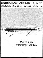
| 22.1 | HNL | . . . . _ . . _ . . | Honolulu | VORTAC | 114.80 | 137 | 128 |
| 25.7 | NGF | _ . _ _ . . . _ . | Kaneohe Bay | TACAN | 114.60 | 106 | 97 |
| 33.4 | CKH | _ . _ . _ . _ . . . . | Koko Head | VORTAC | 113.90 | 124 | 115 |
| 63.3 | MKK | _ _ _ . _ _ . _ | Molokai | VORTAC | 116.10 | 114 | 105 |
| 67.7 | LIH | . _ . . . . . . . . | Lihue | VORTAC | 113.50 | 290 | 281 |
| 76.7 | SOK | . . . _ _ _ _ . _ | South Kauai | VORTAC | 115.40 | 284 | 275 |
| 83.9 | LLD | . _ . . . _ . . _ . . | Lanai | NDB | 353 | 125 | 116 |
| 84.3 | LNY | . _ . . _ . _ . _ _ | Lanai | VORTAC | 117.70 | 125 | 116 |
| 92.6 | NBS | _ . _ . . . . . . | Barking Sands Pmrf | TACAN | 112.60 | 287 | 278 |
Nearby Airports with Fuel
| Dist (NM) | Name (Airport IDs) | True Hdg | Mag Hdg | Fuel Grade |
|---|---|---|---|---|
| 22.0 | Daniel K Inouye International Airport (HNL PHNL HNL) |
135 | 126 | 100, Jet A, Jet A-1+ |
| 67.9 | Lihue Airport (LIH PHLI LIH) |
290 | 281 | 100, Jet A |
| 84.4 | Lanai Airport (LNY PHNY LNY) |
124 | 115 | Jet A |
Notices to Airmen (NOTAMS)
Remarks
| A110-1 | SIMULTANEOUS GLIDER/POWERED ACFT OPNS. |
| A110-11 | ULTRALIGHTS ON & INVOF ARPT. |
| A110-12 | TREE LINE WITH 90 FT TREES NORTH & SOUTH OF RY APRXLY 425 FT FROM CNTRLN. |
| A110-13 | MARKED DEPRESSION INVOF THE AUTOMATED FUEL PUMP ON SOUTHWESTERN APRON. |
| A110-15 | PPR FOR CIVIL ACFT 12500 LBS AND OVER, CTC ARPT AIRSIDE OPS MGR AT (808) 836-6428 MON-FRI, 0745-1630. |
| A110-16 | RSTD: PPR FOR ALL MILITARY FLT INTO ARPT CTC USA HAWAII RNG C808-655-1429/4892. |
| A110-18 | FOR CD CTC HONOLULU CONTROL FACILITY AT 808-840-6262. |
| A110-2 | EXTNSV MIL HELICOPTER & GLIDER OPNS DAILY. AEROBATIC TRAINING OFFSHORE N OF AIRFIELD ABV 1500'. |
| A110-3 | CLSD TO CIVIL ACFT SS-SR. |
| A110-5 | SKY DIVING ACTIVITY ON AND INVOF ARPT. |
| A110-6 | CTN: LARGE SEA BIRDS ON AND INVOF ARPT NOVEMBER THROUGH APRIL. |
| A110-7 | NO RUNNING LNDGS WITH SKID TYPE HELICOPTER ON RWY - APVD TWYS ONLY. |
| A110-8 | A 5000 X 75 FT RWY FOR LGT POWERED ACFT HAS BEEN PAINTED IN THE CENTER OF EXISTING 9007 X 75 FT PAVED AREA FOR CIVIL USE STARTING APPROX 2000 FT FM EACH RWY END. |
| A110-9 | POWERED ACFT SHALL KEEP BASE LEG IN CLOSE AND CROSS THE ARPT BOUNDARY FENCES AT OR ABOVE 600 FT MSL IN ORDER TO ASSURE SAFE SEPARATION FROM SAILPLANES/TOWPLANES USING THE FIRST 2000 FT (SHORT OF THE DSPLCE THLD). |
| A12 | US ARMY SUPPORT COMMAND HI, FORT SHAFTER HI 96858. |
| A14 | CUSTODIAN ATTENDANT AT ARPT M-F 0630-1430. |
| A16 | PHONE AT ARPT 637-8270. FAX 637-8291. UNICOM OPERATOR 637-8271. |
| A18 | OPEN TO CIVIL USE THRU AGRMT BTN US ARMY & ST OF HAWAII-CHECK NOTAMS PRIOR TO USE-NO ATCT IN OPN. |
| A2 | LCTD WITHIN DILLINGHAM MILITARY RESERVATION. |
| A30-08/26 | RWY 08/26 CLSD FOR MILITARY TRAINING 0800-1700Z. |
| A57-08 | 50:1 TO DSPLCD THR. |
| A57-26 | APCH RATIO 50:1 TO DSPLCD THLD. |
| A82 | UNICOM OPER 0900-1700. |
| A83 | WIND INDCRS ARE NOT LGTD. |
Runways
Runway Summary
| Runways: | 08/26 |
| Longest Runway: | 08/26 is 9007 ft (2745 m) long |
| Runways with an Instrument Approach: |
HDH Airport Runway Details
| Runway 08/26 | 9007 ft x 75 ft (2745 m x 23 m) | |
| Runway Length Source: | MILITARY as of 01/12/1994 | |
| Surface: | Asphalt - Fair condition - No special surface treatment | |
Runway Weight Bearing Capacity (in thousands of pounds) |
||
| Single Wheel Landing Gear: | 40.0 | |
| Dual Wheel Landing Gear: | 152.0 | |
| Dual Tandem Wheel Landing Gear: | 180.0 | |
Runway 08 |
Runway 26 |
|
Elevation: |
14.2 | 10.2 |
Latitude: |
21-34-46.5570N | 21-34-45.6500N |
Longitude: |
158-12-37.9250W | 158-11-02.5010W |
|
Runway True Alignment: |
091 | 271 |
Glide Path Angle: |
0.0 degrees | 0.0 degrees |
Traffic Pattern: |
Left | Right |
Runway Markings Type: |
Basic | Basic |
Runway Markings Condition: |
Fair | Fair |
Object at End: |
TREES | |
Object Height: |
60 | |
Distance from End: |
1400 | |
Object Centerline Offset: |
100 ft. right of centerline | |
REIL: |
No | No |
Touchdown Lights: |
No | No |
Centerline Lights: |
No | No |
Threshold Elevation: |
12.2 | 10.1 |
Displaced Threshold: |
1993 | 1995 |
Threshold Latitude: |
21-34-46.3580N | 21-34-45.8520N |
Threshold Longitude: |
158-12-16.8140W | 158-11-23.6370W |
Services
Airframe Repair: |
None |
Powerplant Repair: |
None |
Bottled Oxygen: |
None |
Bulk Oxygen: |
None |
Fuel Available: |
Jet A |
Landing Fees: |
No |
Parking: |
Tiedowns available |
Maps & Diagrams
HDH Sectional
Flight Planning
at skyvector.com
at skyvector.com