Location
Latitude: |
39-21-49.5000N (39.36375) |
Longitude: |
084-31-19.0000W (-84.521944) |
Elevation: |
631.8 feet MSL (193 m MSL) |
Magnetic Variation: |
6.1 W (as of April 2024 from WMM2020 model) |
Time Zone: |
UTC -5.0 (Standard Time) UTC -4.0 (Daylight Savings Time) |
From City: |
03 N.M. SE of Hamilton, Ohio |
Found On: |
Cincinnati Chart |
FAA Region: |
AGL |
Contacts
Manager: |
Publicly owned: |
| JOSH CLAYTON 2820 AIRPORT ROAD EAST HAMILTON, OH 45015-1499 513-785-5444 |
BUTLER COUNTY BD OF COMMISSIONERS 2820 AIRPORT ROAD EAST HAMILTON, OH 45015-1499 513-887-3412 |
Operations
Airport Status: |
Operational |
Facility Use: |
Public |
Type: |
Airport |
Activation Date: |
12/1937 |
Control tower: |
No |
Attendance (Months/Days/Hours): |
Months/Days/Hours NOV-MAR/ALL/0700-2100 |
Boundary ARTCC: |
ZID (Indianapolis) |
Responsible ARTCC: |
ZID (Indianapolis) |
Lighting Schedule: |
SEE RMK |
Segmented Circle Indicator: |
No |
Traffic Pattern Altitude (MSL): |
1632 feet (497 m) |
NOTAMs Facility: |
HAO |
NOTAM-D Service: |
Yes |
International Airport of Entry: |
No |
Customs Landing Rights: |
No |
Military Landing Rights: |
Yes |
Civil/Military Joint Use: |
No |
Based Aircraft
| Single Engine: | 118 |
| Multi Engine: | 16 |
| Jet Engine: | 5 |
| GA Helicopters: | 2 |
| Gliders: | 1 |
Annual Operations (as of 09/22/2022)
| Total Operations: | 55528 | |
| Air Taxi: | 11350 | 20.4% |
| GA Local: | 14882 | 26.8% |
| GA Itinerant: | 29296 | 52.8% |
Communications
| CTAF: | 123.050 |
| Unicom: | 123.050 |
| Approach: | CINCINNATI |
| Departure: | CINCINNATI |
| ASOS: | 121.425 (513-863-6137) |
Fixed Based Operators (FBOs) & Fuel
(Click on a business for detail)
Please help us keep this information up to date. This is a FREE SERVICE just like everything else on Airport Guide! If you see that a business needs to be added, modified, or deleted please fill out our Update Form.
To add, modify, or delete a business click here.
Please help us keep this information up to date. This is a FREE SERVICE just like everything else on Airport Guide! If you see that a business needs to be added, modified, or deleted please fill out our Update Form.
Area Code: 513 |
| Business Name | Frequency | Phone | Fuel Grade |
|---|---|---|---|
| Pro Aero, Inc.
Update FBO info |
Unicom 123.05 | 896-9999 | 80, 100LL, Jet A |
Flight Service Stations
| Primary | Alternate | |
| FSS on Field: | N | |
| FSS Name (ID): | Dayton(DAY) | |
| Frequency: | ||
| Toll Free Phone: | 1-800-WX-BRIEF |
Instrument Procedures / Charts
FAA Terminal Procedures valid from 0901Z 03/21/24 to 0901Z 04/18/24.
There are various types of charts available for an airport. They are listed in the Page Type column. Here is a legend for those types:
APD - Airport Diagram
DP - Departure Procedure Charts
HOT - Hot Spots
IAP - Instrument Approach Procedure Charts
MIN - Minimums
STAR - Standard Terminal Arrival Charts
| Page Type | Page Name | Volume | Action Since Last Cycle |
|---|---|---|---|
| IAP | ILS OR LOC RWY 29 | EC-2 | |
| IAP | RNAV (GPS) RWY 11 | EC-2 | |
| IAP | RNAV (GPS) RWY 29 | EC-2 | |
| MIN | ALTERNATE MINIMUMS | EC-2 | |
| MIN | TAKEOFF MINIMUMS | EC-2 | |
| STAR | CINCE NINE | EC-2 | Deleted |
| STAR | HARDU FIVE | EC-2 | |
| STAR | HARDU FIVE[DELIMITER] CONT.1 | EC-2 | |
| STAR | HEDEE FOUR | EC-2 | |
| STAR | HEDEE FOUR[DELIMITER] CONT.1 | EC-2 | |
| STAR | SHELBYVILLE SIX | EC-2 | |
| STAR | SHELBYVILLE SIX[DELIMITER] CONT.1 | EC-2 |
Terminal Procedures are only available for airports in several countries with more being added all the time. If you are looking for a specific country's charts, please send an email to support(at)airportguide.com stating the country name. This will be used to prioritize the implementation.
Navigation Aids (Navaids) near HAO
| Dist (NM) | ID | Morse Code | Name | Type | Freq | True Hdg | Mag Hdg |
|---|---|---|---|---|---|---|---|
| 2.4 | HAO | . . . . . _ _ _ _ | Hamilton | NDB | 260 | 283 | 289 |
| 8.8 | HKF | . . . . _ . _ . . _ . | Hook Field | NDB | 239 | 23 | 29 |
| 11.5 | MDE | _ _ _ . . . | Madeira | NDB | 379 | 137 | 143 |
| 14.8 | OXD | _ _ _ _ . . _ _ . . | Oxford | NDB | 282 | 305 | 311 |
| 14.8 | LUK | . _ . . . . _ _ . _ | Cincinnati | NDB | 335 | 145 | 151 |
| 15.8 | MW | _ _ . _ _ | Onida | NDB | 223 | 35 | 41 |
| 16.1 | LUK | . _ . . . . _ _ . _ | Cincinnati Muni/Lunken | VOT | 108.40 | 163 | 169 |
| 22.4 | PWF | . _ _ . . _ _ . . _ . | Sportys | NDB | 245 | 140 | 146 |
| 22.4 | UR | . . _ . _ . | Burln | NDB | 321 | 211 | 217 |
| 22.5 | CVG | _ . _ . . . . _ _ _ . | Cincinnati | VORTAC | 117.30 | 202 | 208 |
| 27.7 | RID | . _ . . . _ . . | Richmond | DME | 110.6 | 328 | 334 |
| 30.0 | HW | . . . . . _ _ | Cubla | NDB | 299 | 90 | 96 |
| 30.3 | AT | . _ _ | Bruny | NDB | 315 | 16 | 22 |
| 33.7 | MXQ | _ _ _ . . _ _ _ . _ | Midwest | VOR-DME | 112.90 | 83 | 89 |
| 34.2 | HLB | . . . . . _ . . _ . . . | Batesville | NDB | 254 | 268 | 274 |
| 34.8 | FFO | . . _ . . . _ . _ _ _ | Patterson | TACAN | 109.20 | 38 | 44 |
| 35.1 | DAY | _ . . . _ _ . _ _ | Dayton J M Cox-Day | VOT | 111.00 | 23 | 29 |
| 37.1 | IL | . . . _ . . | Airbo | NDB | 407 | 77 | 83 |
| 37.5 | SQ | . . . _ _ . _ | Pnthr | NDB | 227 | 311 | 317 |
| 39.6 | DQN | _ . . _ _ . _ _ . | Dayton | VOR-DME | 114.50 | 8 | 14 |
Nearby Airports with Fuel
Notices to Airmen (NOTAMS)
Remarks
| A110*G | THIS AIRPORT HAS BEEN SURVEYED BY THE NATIONAL GEODETIC SURVEY. |
| A110-1 | FOR CD CTC CINCINNATI APCH AT 859-372-6440. |
| A16 | CELL 513-309-0562. |
| A31-11/29 | 750 FT STWY WEST END. |
| A42-11 | FADED. |
| A42-29 | FADED. |
| A70-FUEL-A+ | JET A+ AVBL ON REQ AT DLVY. |
| A75 | PRIOR CDN RQRD FOR TSNT HNGR. |
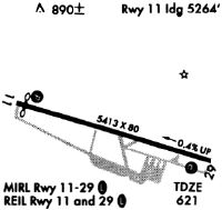
| A81-APT | ACTVT MALS RWY 29; REIL RWY 11 & 29; PAPI RWY 11 & 29; MIRL RWY 11/29 - CTAF. |
Runways
Runway Summary
| Runways: | 11/29 |
| Longest Runway: | 11/29 is 5500 ft (1676 m) long |
| Runways with an Instrument Approach: | 29 |
HAO Airport Runway Details
| Runway 11/29 | 5500 ft x 100 ft (1676 m x 30 m) | |
| Runway Length Source: | NGS as of 09/06/2005 | |
| Surface: | Asphalt - Good condition - No special surface treatment | |
| Runway Edge Lights: | Medium Intensity | |
Runway Weight Bearing Capacity (in thousands of pounds) |
||
| Single Wheel Landing Gear: | 60.0 | |
| Dual Wheel Landing Gear: | 75.0 | |
| Dual Tandem Wheel Landing Gear: | 39.0 | |
Runway 11 |
Runway 29 |
|
Elevation: |
631.8 | 618.9 |
Latitude: |
39-21-58.9958N | 39-21-40.0730N |
Longitude: |
084-31-51.8192W | 084-30-46.1758W |
|
Runway True Alignment: |
110 | 290 |
ILS Type: |
ILS/DME | |
Glide Path Angle: |
3.5 degrees | 3.0 degrees |
Traffic Pattern: |
Left | Left |
Runway Markings Type: |
Nonprecision Instrument | Precision Instrument |
Runway Markings Condition: |
Poor | Poor |
Object at End: |
TREES | TREES |
Object Height: |
60 | 130 |
Object Marked/Lighted?: |
Lighted | |
Distance from End: |
1450 | 3450 |
Object Centerline Offset: |
360 ft. right of centerline | 100 ft. left of centerline |
Visual Glide Slope Indicators: |
4-Light PAPI On Left Side Of Runway | 4-Light PAPI On Left Side Of Runway |
Approach Light System: |
1,400 Foot Medium Intensity Approach Lighting System | |
REIL: |
Yes | Yes |
Touchdown Lights: |
No | No |
Centerline Lights: |
No | No |
Threshold Crossing Height: |
27 | 47 |
Services
Airframe Repair: |
Minor |
Powerplant Repair: |
Minor |
Fuel Available: |
100LL, Jet A |
Landing Fees: |
No |
Parking: |
Tiedowns available |
Maps & Diagrams
HAO Sectional
Flight Planning
at skyvector.com
at skyvector.com