Location
Latitude: |
36-04-41.6160N (36.078227) |
Longitude: |
093-45-17.1170W (-93.754755) |
Elevation: |
1747.9 feet MSL (533 m MSL) |
Magnetic Variation: |
0.7 E (as of April 2024 from WMM2020 model) |
Time Zone: |
UTC -6.0 (Standard Time) UTC -5.0 (Daylight Savings Time) |
From City: |
02 N.M. SW of Huntsville, Arkansas |
Found On: |
Kansas City Chart |
FAA Region: |
ASW |
Contacts
Manager: |
Publicly owned: |
| CHARLES COGER PO BOX 844 HUNTSVILLE, AR 72740 479-738-7287 |
CITY OF HUNTSVILLE PO BOX 844 HUNTSVILLE, AR 72740 479-738-6607 |
Operations
Airport Status: |
Operational |
Facility Use: |
Public |
Type: |
Airport |
Activation Date: |
07/1986 |
Control tower: |
No |
Attendance (Months/Days/Hours): |
Months/Days/Hours Unattended |
Boundary ARTCC: |
ZME (Memphis) |
Responsible ARTCC: |
ZME (Memphis) |
Lighting Schedule: |
SEE RMK |
Segmented Circle Indicator: |
No |
Traffic Pattern Altitude (MSL): |
2748 feet (838 m) |
NOTAMs Facility: |
JBR |
NOTAM-D Service: |
Yes |
Based Aircraft
| Single Engine: | 28 |
| Ultralights: | 2 |
Annual Operations (as of 11/30/2023)
| Total Operations: | 5000 | |
| GA Local: | 3000 | 60.0% |
| GA Itinerant: | 1800 | 36.0% |
| Military Aircraft: | 200 | 4.0% |
Communications
| CTAF: | 122.800 |
| Unicom: | 122.800 |
| Approach: | RAZORBACK 126.6 126.6 MEMPHIS ARTCC |
| Departure: | RAZORBACK 126.6 126.6 MEMPHIS ARTCC |
- APCH/DEP SVC PRVDD BY MEMPHIS ARTCC ON FREQS 126.1/269.0 (FAYETTEVILLE RCAG) WHEN RAZORBACK APCH CTL CLSD.
Fixed Based Operators (FBOs) & Fuel
(Click on a business for detail)
Please help us keep this information up to date. This is a FREE SERVICE just like everything else on Airport Guide! If you see that a business needs to be added, modified, or deleted please fill out our Update Form.
To add, modify, or delete a business click here.
Please help us keep this information up to date. This is a FREE SERVICE just like everything else on Airport Guide! If you see that a business needs to be added, modified, or deleted please fill out our Update Form.
Area Code: 501 |
| Business Name | Frequency | Phone | Fuel Grade |
|---|
Flight Service Stations
| Primary | Alternate | |
| FSS on Field: | N | |
| FSS Name (ID): | Jonesboro(JBR) | |
| Frequency: | ||
| Toll Free Phone: | 1-800-WX-BRIEF |
Instrument Procedures / Charts
FAA Terminal Procedures valid from 0901Z 03/21/24 to 0901Z 04/18/24.
There are various types of charts available for an airport. They are listed in the Page Type column. Here is a legend for those types:
APD - Airport Diagram
DP - Departure Procedure Charts
HOT - Hot Spots
IAP - Instrument Approach Procedure Charts
MIN - Minimums
STAR - Standard Terminal Arrival Charts
| Page Type | Page Name | Volume | Action Since Last Cycle |
|---|---|---|---|
| IAP | RNAV (GPS) RWY 12 | SC-1 | |
| IAP | RNAV (GPS) RWY 30 | SC-1 | |
| MIN | TAKEOFF MINIMUMS | SC-1 |
Terminal Procedures are only available for airports in several countries with more being added all the time. If you are looking for a specific country's charts, please send an email to support(at)airportguide.com stating the country name. This will be used to prioritize the implementation.
Navigation Aids (Navaids) near H34
| Dist (NM) | ID | Morse Code | Name | Type | Freq | True Hdg | Mag Hdg |
|---|---|---|---|---|---|---|---|
| 20.4 | RZC | . _ . _ _ . . _ . _ . | Razorback | VORTAC | 116.40 | 299 | 298 |
| 21.6 | DAK | _ . . . _ _ . _ | Drake | DME | 115.25 | 264 | 263 |
| 27.6 | RO | . _ . _ _ _ | Rogrs | NDB | 263 | 326 | 325 |
| 29.6 | HR | . . . . . _ . | Bakky | NDB | 395 | 76 | 76 |
| 29.9 | HRO | . . . . . _ . _ _ _ | Harrison | VOR-DME | 112.50 | 61 | 61 |
| 36.2 | SLG | . . . . _ . . _ _ . | Siloam Springs | NDB | 284 | 280 | 279 |
| 39.9 | CZE | _ . _ . _ _ . . . | Clarksville | NDB | 201 | 156 | 155 |
| 48.4 | FSM | . . _ . . . . _ _ | Fort Smith | VORTAC | 110.40 | 211 | 210 |
| 48.9 | FS | . . _ . . . . | Wizer | NDB | 223 | 207 | 206 |
| 56.4 | EOS | . _ _ _ . . . | Neosho | DME | 117.3 | 324 | 323 |
| 57.3 | GK | _ _ . _ . _ | Jembo | NDB | 311 | 217 | 216 |
| 58.8 | RUE | . _ . . . _ . | Russellville | NDB | 379 | 146 | 146 |
| 61.4 | TQH | _ _ _ . _ . . . . | Tahlequah | NDB | 215 | 261 | 260 |
| 64.2 | FLP | . . _ . . _ . . . _ _ . | Flippin | DME | 116.05 | 77 | 77 |
| 65.0 | IQS | . . _ _ . _ . . . | Sallisaw | NDB | 520 | 231 | 230 |
| 70.4 | MPJ | _ _ . _ _ . . _ _ _ | Morrilton | NDB | 410 | 144 | 144 |
| 70.8 | DGD | _ . . _ _ . _ . . | Dogwood | VORTAC | 109.40 | 36 | 36 |
| 77.8 | JL | . _ _ _ . _ . . | Lunns | NDB | 344 | 330 | 329 |
| 79.3 | SGF | . . . _ _ . . . _ . | Springfield | VORTAC | 116.90 | 14 | 13 |
| 88.1 | CWS | _ . _ . . _ _ . . . | Conway | NDB | 302 | 132 | 132 |
Nearby Airports with Fuel
Notices to Airmen (NOTAMS)
Remarks
| A110-1 | ULTRALIGHT ACTIVITY ON & INVOF ARPT. |
| A110-2 | FOR CD CTC RAZORBACK APCH 479-649-2416, WHEN APCH CLSD CTC MEMPHIS ARTCC AT 901-368-8453/8449. |
| A33-03/21 | STEEP DROP OFF AT RY ENDS. |
| A70-FUEL-10 | 0LL SELF SERVICE FUEL AVBL 24 HRS WITH CREDIT CARD. |
| A81-APT | ACTVT MIRL RY 12/30 - CTAF. |
Runways
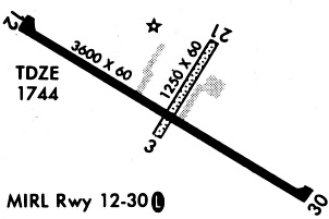
Runway Summary
| Runways: | 03/21 12/30 |
| Longest Runway: | 12/30 is 3601 ft (1098 m) long |
| Runways with an Instrument Approach: |
H34 Airport Runway Details
| Runway 03/21 | 1250 ft x 60 ft (381 m x 18 m) | |
| Runway Length Source: | FAA-EST as of 10/27/2022 | |
| Surface: | Turf - Fair condition - No special surface treatment | |
Runway 03 |
Runway 21 |
|
Elevation: |
1739.0 | 1738.0 |
Latitude: |
36-04-38.4800N | 36-04-48.2700N |
Longitude: |
093-45-18.8900W | 093-45-09.6100W |
|
Runway True Alignment: |
038 | 218 |
Glide Path Angle: |
0.0 degrees | 0.0 degrees |
Runway Markings Type: |
Nonstandard (other than numbers only) | Nonstandard (other than numbers only) |
Runway Markings Condition: |
Fair | Fair |
| Runway 12/30 | 3601 ft x 60 ft (1098 m x 18 m) | |
| Runway Length Source: | 3RD PARTY SURVEY as of 08/09/2011 | |
| Surface: | Turf - Fair condition - No special surface treatment | |
| Runway Edge Lights: | Medium Intensity | |
Runway Weight Bearing Capacity (in thousands of pounds) |
||
| Single Wheel Landing Gear: | 12.5 | |
Runway 12 |
Runway 30 |
|
Elevation: |
1743.6 | 1744.9 |
Latitude: |
36-04-51.1193N | 36-04-30.8925N |
Longitude: |
093-45-36.1637W | 093-45-00.0614W |
|
Runway True Alignment: |
125 | 305 |
Glide Path Angle: |
0.0 degrees | 0.0 degrees |
Runway Markings Type: |
Nonprecision Instrument | Nonprecision Instrument |
Runway Markings Condition: |
Good | Poor |
Services
Airframe Repair: |
None |
Powerplant Repair: |
None |
Bottled Oxygen: |
None |
Bulk Oxygen: |
None |
Fuel Available: |
100LL |
Landing Fees: |
No |
Parking: |
Tiedowns available |
Maps & Diagrams
H34 Sectional
Flight Planning
at skyvector.com
at skyvector.com