
Location
Latitude: |
42-52-51.0000N (42.880833) |
Longitude: |
085-31-22.1000W (-85.522806) |
Elevation: |
793.6 feet MSL (242 m MSL) |
Magnetic Variation: |
5.9 W (as of April 2024 from WMM2020 model) |
Time Zone: |
UTC -5.0 (Standard Time) UTC -4.0 (Daylight Savings Time) |
From City: |
06 N.M. SE of Grand Rapids, Michigan |
Found On: |
Chicago Chart |
FAA Region: |
AGL |
Contacts
Manager: |
Publicly owned: |
| TORRANCE RICHARDSON 5500 44TH ST SE GRAND RAPIDS, MI 49512 616-233-6000 |
GERALD R FORD INTL ARPT AUTH 5500 44TH ST SE GRAND RAPIDS, MI 49512 616-233-6000 |
Operations
Airport Status: |
Operational |
Facility Use: |
Public |
Type: |
Airport |
Activation Date: |
05/1963 |
Control tower: |
Yes |
Attendance (Months/Days/Hours): |
Months/Days/Hours ALL/ALL/ALL |
Boundary ARTCC: |
ZAU (Chicago) |
Responsible ARTCC: |
ZAU (Chicago) |
Lighting Schedule: |
SEE RMK |
Segmented Circle Indicator: |
No |
Traffic Pattern Altitude (MSL): |
1794 feet (547 m) |
NOTAMs Facility: |
GRR |
NOTAM-D Service: |
Yes |
International Airport of Entry: |
No |
Customs Landing Rights: |
Yes |
Military Landing Rights: |
Yes |
Civil/Military Joint Use: |
No |
Aircraft Rescue and Firefighting: |
Class I ARFF Index: C Air Carrier Service: Scheduled Certification Date: 05/1973 |
Based Aircraft
| Single Engine: | 32 |
| Multi Engine: | 8 |
| Jet Engine: | 44 |
| GA Helicopters: | 6 |
Annual Operations (as of 12/31/2022)
| Total Operations: | 74316 | |
| Commercial: | 31623 | 42.6% |
| Air Taxi: | 13283 | 17.9% |
| GA Local: | 5401 | 7.3% |
| GA Itinerant: | 23581 | 31.7% |
| Military Aircraft: | 428 | 0.6% |
Communications
| CTAF: | 135.650 |
| Unicom: | 122.950 |
| Tower: | GRAND RAPIDS 135.65 339.8 Hrs: 0530-0000 |
| Clearance Del.: | 119.3 |
| Ground: | 121.8 |
| Approach: | GREAT LAKES 124.6 ;NORTH 124.6 ;NORTH 124.6 ;NORTH 124.6 ;NORTH 124.6 ;NORTH 124.6 ;NORTH CHICAGO ARTCC |
| Departure: | GREAT LAKES 124.6 ;NORTH 124.6 ;NORTH 124.6 ;NORTH 124.6 ;NORTH 124.6 ;NORTH 124.6 ;NORTH CHICAGO ARTCC |
| ATIS: | 118.725 Hrs: 24 |
| ASOS: | (616-575-1953) |
| EMERG: | 121.5 |
| EMERG: | 243.0 |
- APCH/DEP SVC PRVDD BY CHICAGO ARTCC (ZAU) ON FREQS 128.4 (GRAND RAPIDS RCAG) WHEN GREAT LAKES APCH CTL CLSD.
Fixed Based Operators (FBOs) & Fuel
(Click on a business for detail)
Please help us keep this information up to date. This is a FREE SERVICE just like everything else on Airport Guide! If you see that a business needs to be added, modified, or deleted please fill out our Update Form.
To add, modify, or delete a business click here.
Please help us keep this information up to date. This is a FREE SERVICE just like everything else on Airport Guide! If you see that a business needs to be added, modified, or deleted please fill out our Update Form.
Area Code: 616 |
| Business Name | Frequency | Phone | Fuel Grade |
|---|---|---|---|
| Aargus Air Charter
Website Update FBO info |
616-956-7600, 888-431-0705 | ||
| Avflight Grand Rapids
Website Update FBO info |
616.226.4477 | 100LL, Jet A | |

|
AvFuel | 100LL - 4.99 USD per gallon on 6/1/2020 |
Trucks Avflight Network Fuel Pricing Discounts |
|
|
AvFuel | Jet A - 5.85 USD per gallon on 6/1/2020 |
Trucks Avflight Network Fuel Pricing Discounts |
|
|
AvFuel | Jet A+ - 5.95 USD per gallon on 6/1/2020 |
Trucks Avflight Network Fuel Pricing Discounts |
| Gourmet Airfare
Website Update FBO info |
866-JET-FOOD (538-3663) | ||
| Mayday Avionics, Inc.
Update FBO info |
123.4 | 957-4920 | |
| Northern Air, Inc.
Update FBO info |
Unicom 122.95, Arinc 131.725 | (616) 942-0678, 336-4700, 800-262-4953 | 100LL, Jet A |
|
|
Phillips | 100LL - 2.96 USD per gallon on 2/20/02 |
Trucks |
| Rapid Air, Inc.
Update FBO info |
Unicom 122.95 | 957-5050, 887-7373 | 100LL, Jet A |
| Signature Flight Support
Update FBO info |
Unicom: 122.95, Arinc: 130.525 | +1 616 336 4711 |
Flight Service Stations
| Primary | Alternate | |
| FSS on Field: | N | |
| FSS Name (ID): | Lansing(LAN) | |
| Frequency: | ||
| Toll Free Phone: | 1-800-WX-BRIEF |
Instrument Procedures / Charts
FAA Terminal Procedures valid from 0901Z 03/21/24 to 0901Z 04/18/24.
There are various types of charts available for an airport. They are listed in the Page Type column. Here is a legend for those types:
APD - Airport Diagram
DP - Departure Procedure Charts
HOT - Hot Spots
IAP - Instrument Approach Procedure Charts
MIN - Minimums
STAR - Standard Terminal Arrival Charts
| Page Type | Page Name | Volume | Action Since Last Cycle |
|---|---|---|---|
| APD | AIRPORT DIAGRAM | EC-1 | |
| HOT | HOT SPOT | EC-1 | |
| IAP | ILS OR LOC RWY 08R | EC-1 | |
| IAP | ILS OR LOC RWY 26L | EC-1 | |
| IAP | ILS OR LOC RWY 35 | EC-1 | |
| IAP | ILS RWY 35 (SA CAT I - II) | EC-1 | |
| IAP | RNAV (GPS) RWY 08L | EC-1 | |
| IAP | RNAV (GPS) RWY 08R | EC-1 | |
| IAP | RNAV (GPS) RWY 17 | EC-1 | |
| IAP | RNAV (GPS) RWY 26L | EC-1 | |
| IAP | RNAV (GPS) RWY 26R | EC-1 | |
| IAP | RNAV (GPS) RWY 35 | EC-1 | |
| IAP | VOR RWY 17 | EC-1 | |
| MIN | ALTERNATE MINIMUMS | EC-1 | |
| MIN | TAKEOFF MINIMUMS | EC-1 |
Terminal Procedures are only available for airports in several countries with more being added all the time. If you are looking for a specific country's charts, please send an email to support(at)airportguide.com stating the country name. This will be used to prioritize the implementation.
Navigation Aids (Navaids) near GRR
| Dist (NM) | ID | Morse Code | Name | Type | Freq | True Hdg | Mag Hdg |
|---|---|---|---|---|---|---|---|
| 5.8 | VIO | . . . _ . . _ _ _ | Victory | VOR-DME | 115.95 | 168 | 174 |
| 6.4 | GR | _ _ . . _ . | Knobs | NDB | 263 | 81 | 87 |
| 28.5 | MKG | _ _ _ . _ _ _ . | Muskegon | TACAN | 115.20 | 307 | 313 |
| 34.5 | BT | _ . . . _ | Batol | NDB | 272 | 154 | 160 |
| 35.8 | PMM | . _ _ . _ _ _ _ | Pullman | VOR-DME | 112.10 | 226 | 232 |
| 36.3 | BTL | _ . . . _ . _ . . | Battle Creek | VORTAC | 109.40 | 160 | 166 |
| 37.6 | LAN | . _ . . . _ _ . | Lansing | DME | 110.8 | 104 | 110 |
| 38.7 | AZO | . _ _ _ . . _ _ _ | Kalamazoo | DME | 109 | 182 | 188 |
| 42.5 | HIC | . . . . . . _ . _ . | White Cloud | VOR-DME | 117.60 | 348 | 354 |
| 45.0 | AZ | . _ _ _ . . | Austn | NDB | 371 | 180 | 186 |
| 51.5 | ELX | . . _ . . _ . . _ | Keeler | VOR-DME | 116.60 | 211 | 217 |
| 55.4 | HAI | . . . . . _ . . | Three Rivers | NDB | 407 | 183 | 189 |
| 56.2 | MOP | _ _ _ _ _ . _ _ . | Mount Pleasant | VOR-DME | 110.60 | 37 | 43 |
| 57.2 | BE | _ . . . . | Mally | NDB | 397 | 217 | 223 |
| 59.5 | LFD | . _ . . . . _ . _ . . | Litchfield | VOR-DME | 111.20 | 145 | 151 |
| 60.0 | JXN | . _ _ _ _ . . _ _ . | Jackson | DME | 115.45 | 128 | 134 |
| 61.3 | JX | . _ _ _ _ . . _ | Jakso | NDB | 212 | 123 | 129 |
| 64.2 | IRS | . . . _ . . . . | Sturgis | NDB | 382 | 176 | 182 |
| 68.3 | MB | _ _ _ . . . | Olste | NDB | 257 | 58 | 64 |
| 69.5 | OZW | _ _ _ _ _ . . . _ _ | Howell | NDB | 243 | 101 | 107 |
Nearby Airports with Fuel
Notices to Airmen (NOTAMS)
Remarks
| A110-1 | TWY F NORTH OF TWY V, TWY J BTN TWY F & TWY J3 & TWY G CLSD TO AIRCRAFT OVER 100,000 LBS; TWY F SOUTH OF TWY V & TWY J EAST OF TWY F & WEST OF TWY J3 CLSD TO ACFT OVER 47,000 LBS. |
| A110-10 | TWY R NORTH OF TWY D, TWY Y NORTH OF TWY D, TWY Z NORTH OF TWY D AND TWY N ARE NON-MOVEMENT AREAS. |
| A110-11 | PUSHBACK ADVISORIES ON THE TERMINAL RAMP ARE NOT PRVDD BY ATC. |
| A110-14 | ARPT PSNL WILL MNT CTAF WHEN ATCT IS CLSD. |
| A110-15 | TWY Y 400 FT NORTH OF TWY D CLSD TO ACFT OVER 100,000 LBS.; TWY R NORTH OF TWY D CLSD TO ACFT OVER 175,000 LBS. |
| A110-16 | AIR CARRIER APRON CLOSED TO GA AIRCRAFT. |
| A110-17 | CTC FBO FOR THEIR HRS OF OPN. |
| A110-18 | FOR CD WHEN TWR CLSD CTC GREAT LAKES APCH AT 269-459-3344, WHEN APCH CLSD CTC CHICAGO ARTCC AT 630-906-8921. |
| A110-2 | BIRDS ON & INVOF ARPT. |
| A110-8 | NOISE ABATEMENT PROCEDURES: RY 08R DEP ON RY HEADING UNTIL REACHING THE HWY EAST OF ARPT; RY 26L ON APCH TO ARPT TURN FINAL AT HWY EAST OF ARPT. |
| A110-9 | PPR FOR ACFT WITH 171 FT WINGSPAN OR LARGER. |
| A81-APT | WHEN ATCT CLSD ACTVT MALSR RWY 08R, 26L, & 35; REIL RWY 08L, 26R, & 17; HIRL RWY 08R/26L & 17/35; MIRL RWY 08L/26R - CTAF. |
| E80 | MON-FRI TWO HRS PPR FOR CUSTOMS CALL 616-942-5245, PAGER 616-249-5380. CALL PRIOR TO 1600 ON PRECEDING FRIDAY FOR AFTER HOURS SVC. |
Runways
Runway Summary
| Runways: | 08L/26R 08R/26L 17/35 |
| Longest Runway: | 08R/26L is 10001 ft (3048 m) long |
| Runways with an Instrument Approach: | 08R, 26L, 35 |
GRR Airport Runway Details
| Runway 08L/26R | 5001 ft x 100 ft (1524 m x 30 m) | |
| Runway Length Source: | 3RD PARTY SURVEY as of 09/16/2016 | |
| Surface: | Asphalt - Good condition - Saw-cut or plastic grooved | |
| Runway Pavement Class: | 45 /F/C/X/T | |
| Runway Edge Lights: | Medium Intensity | |
Runway Weight Bearing Capacity (in thousands of pounds) |
||
| Single Wheel Landing Gear: | 110.0 | |
| Dual Wheel Landing Gear: | 160.0 | |
Runway 08L |
Runway 26R |
|
Elevation: |
786.2 | 783.8 |
Latitude: |
42-53-19.7894N | 42-53-27.2504N |
Longitude: |
085-32-24.6939W | 085-31-18.2945W |
|
Runway True Alignment: |
081 | 261 |
Glide Path Angle: |
3.0 degrees | 3.0 degrees |
Traffic Pattern: |
Left | Left |
Runway Markings Type: |
Nonprecision Instrument | Nonprecision Instrument |
Runway Markings Condition: |
Good | Good |
Visual Glide Slope Indicators: |
4-Box VASI On Left Side Of Runway | 4-Box VASI On Left Side Of Runway |
REIL: |
Yes | Yes |
Touchdown Lights: |
No | No |
Centerline Lights: |
No | No |
Threshold Crossing Height: |
45 | 33 |
Declared Distances |
||
Take Off Run Avbl. (TORA): |
5001 | 5001 |
Take Off Distance Avbl. (TODA): |
5001 | 5001 |
Actual Stop Dist. Avbl. (ASDA): |
5001 | 5001 |
Landing Dist. Avbl. (LDA): |
5001 | 5001 |
| Runway 08R/26L | 10001 ft x 150 ft (3048 m x 46 m) | |
| Runway Length Source: | 3RD PARTY SURVEY as of 09/16/2016 | |
| Surface: | Asphalt - Good condition - Saw-cut or plastic grooved | |
| Runway Pavement Class: | 62 /R/B/W/T | |
| Runway Edge Lights: | High Intensity | |
Runway Weight Bearing Capacity (in thousands of pounds) |
||
| Dual Wheel Landing Gear: | 190.0 | |
| Dual Tandem Wheel Landing Gear: | 350.0 | |
Runway 08R |
Runway 26L |
|
Elevation: |
791.5 | 789.3 |
Latitude: |
42-52-35.8796N | 42-52-50.8096N |
Longitude: |
085-32-31.8841W | 085-30-19.1183W |
|
Runway True Alignment: |
081 | 261 |
ILS Type: |
ILS | ILS |
Glide Path Angle: |
0.0 degrees | 3.0 degrees |
Traffic Pattern: |
Left | Left |
Runway Markings Type: |
Precision Instrument | Precision Instrument |
Runway Markings Condition: |
Good | Good |
Object at End: |
BLDG | |
Object Height: |
24 | |
Distance from End: |
1170 | |
Visual Glide Slope Indicators: |
4-Light PAPI On Left Side Of Runway | |
Runway Visual Range (RVR): |
Touchdown, Rollout | Touchdown, Rollout |
Approach Light System: |
1,400 Foot Medium Intensity Approach Lighting System With Runway Alignment Indicator Lights | 1,400 Foot Medium Intensity Approach Lighting System With Runway Alignment Indicator Lights |
REIL: |
No | No |
Touchdown Lights: |
No | No |
Centerline Lights: |
No | No |
Threshold Crossing Height: |
73 | |
Declared Distances |
||
Take Off Run Avbl. (TORA): |
10001 | 10001 |
Take Off Distance Avbl. (TODA): |
10001 | 10001 |
Actual Stop Dist. Avbl. (ASDA): |
10001 | 10001 |
Landing Dist. Avbl. (LDA): |
10001 | 10001 |
| Runway 17/35 | 8501 ft x 150 ft (2591 m x 46 m) | |
| Runway Length Source: | 3RD PARTY SURVEY as of 09/16/2016 | |
| Surface: | Asphalt - Good condition - Saw-cut or plastic grooved | |
| Runway Pavement Class: | 60 /R/B/W/T | |
| Runway Edge Lights: | High Intensity | |
Runway Weight Bearing Capacity (in thousands of pounds) |
||
| Dual Wheel Landing Gear: | 190.0 | |
| Dual Tandem Wheel Landing Gear: | 350.0 | |
Runway 17 |
Runway 35 |
|
Elevation: |
782.3 | 789.3 |
Latitude: |
42-53-22.3105N | 42-51-59.3073N |
Longitude: |
085-31-09.3211W | 085-30-52.0705W |
|
Runway True Alignment: |
171 | 351 |
ILS Type: |
ILS | |
Glide Path Angle: |
3.0 degrees | 3.0 degrees |
Runway Markings Type: |
Nonprecision Instrument | Precision Instrument |
Runway Markings Condition: |
Good | Good |
Visual Glide Slope Indicators: |
4-Light PAPI On Right Side Of Runway | 4-Light PAPI On Right Side Of Runway |
Runway Visual Range (RVR): |
Touchdown, Rollout | Touchdown, Rollout |
Approach Light System: |
1,400 Foot Medium Intensity Approach Lighting System With Runway Alignment Indicator Lights | |
REIL: |
Yes | No |
Touchdown Lights: |
No | No |
Centerline Lights: |
No | No |
Threshold Crossing Height: |
50 | 74 |
Declared Distances |
||
Take Off Run Avbl. (TORA): |
8501 | 8501 |
Take Off Distance Avbl. (TODA): |
8501 | 8501 |
Actual Stop Dist. Avbl. (ASDA): |
8501 | 8501 |
Landing Dist. Avbl. (LDA): |
8501 | 8501 |
Services
Airframe Repair: |
Major |
Powerplant Repair: |
Major |
Bottled Oxygen: |
None |
Bulk Oxygen: |
None |
Fuel Available: |
100LL |
Landing Fees: |
No |
Parking: |
Hangars and tiedowns available |
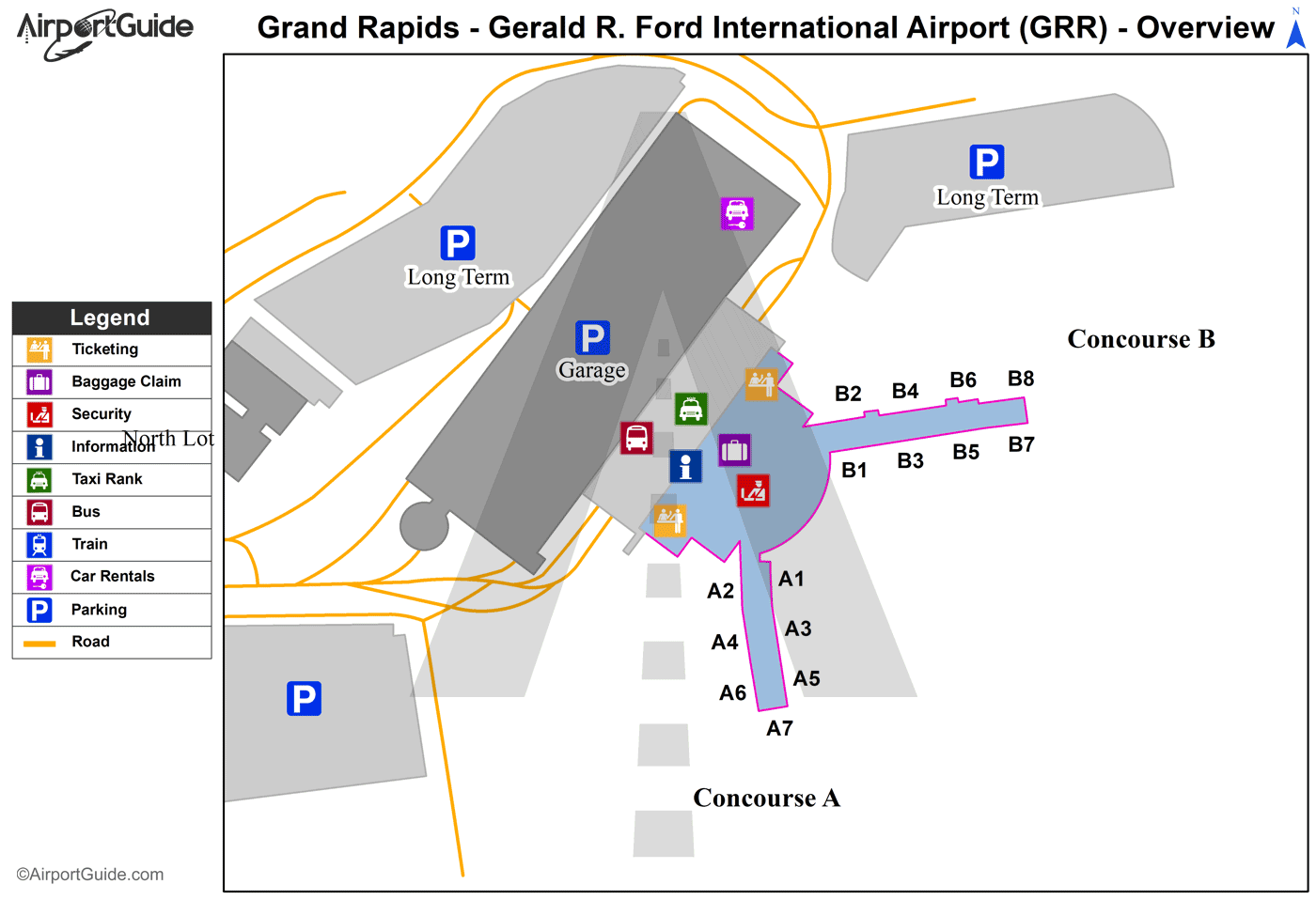
Maps & Diagrams
GRR Sectional
Flight Planning
at skyvector.com
at skyvector.com
