Location
Latitude: |
62-09-15.6050N (62.154335) |
Longitude: |
145-27-19.0500W (-145.455292) |
Elevation: |
1586.1 feet MSL (483 m MSL) |
Magnetic Variation: |
16.3 E (as of April 2024 from WMM2020 model) |
Time Zone: |
UTC -9.0 (Standard Time) UTC -8.0 (Daylight Savings Time) |
From City: |
04 N.M. NE of Gulkana, Alaska |
Found On: |
Anchorage Chart |
FAA Region: |
AAL |
Contacts
Manager: |
Publicly owned: |
| CHAD HELLER BOX 7 GLENNALLEN, AK 99588 907-822-3222 |
ALASKA DOT&PF NORTHERN REGION , 2301 PEGER RD FAIRBANKS, AK 99701 907-451-2200 |
Operations
Airport Status: |
Operational |
Facility Use: |
Public |
Type: |
Airport |
Activation Date: |
07/1947 |
Control tower: |
No |
Attendance (Months/Days/Hours): |
Months/Days/Hours JUN-SEP/MON-FRI/0900-1700 |
Boundary ARTCC: |
ZAN (Anchorage) |
Responsible ARTCC: |
ZAN (Anchorage) |
Lighting Schedule: |
SEE RMK |
Segmented Circle Indicator: |
Yes |
Traffic Pattern Altitude (MSL): |
2586 feet (788 m) |
NOTAMs Facility: |
GKN |
NOTAM-D Service: |
Yes |
International Airport of Entry: |
No |
Customs Landing Rights: |
No |
Military Landing Rights: |
Yes |
Civil/Military Joint Use: |
No |
Based Aircraft
| Single Engine: | 21 |
Annual Operations (as of 12/31/2019)
| Total Operations: | 5122 | |
| Commercial: | 996 | 19.4% |
| Air Taxi: | 540 | 10.5% |
| GA Local: | 1576 | 30.8% |
| GA Itinerant: | 1855 | 36.2% |
| Military Aircraft: | 155 | 3.0% |
Communications
| CTAF: | 122.900 |
| ASOS: | 134.85 (907-822-3707) |
- APCH/DEP SVC PRVDD BY ANCHORAGE ARTCC ON FREQS 119.5/317.5 (GULKANA RCAG).
Fixed Based Operators (FBOs) & Fuel
(Click on a business for detail)
Please help us keep this information up to date. This is a FREE SERVICE just like everything else on Airport Guide! If you see that a business needs to be added, modified, or deleted please fill out our Update Form.
To add, modify, or delete a business click here.
Please help us keep this information up to date. This is a FREE SERVICE just like everything else on Airport Guide! If you see that a business needs to be added, modified, or deleted please fill out our Update Form.
Area Code: 907 |
| Business Name | Frequency | Phone | Fuel Grade |
|---|
Flight Service Stations
| Primary | Alternate | |
| FSS on Field: | N | |
| FSS Name (ID): | Kenai(ENA) | |
| Frequency: | ||
| Toll Free Phone: | 1-866-864-1737 |
Instrument Procedures / Charts
FAA Terminal Procedures valid from 0901Z 03/21/24 to 0901Z 04/18/24.
There are various types of charts available for an airport. They are listed in the Page Type column. Here is a legend for those types:
APD - Airport Diagram
DP - Departure Procedure Charts
HOT - Hot Spots
IAP - Instrument Approach Procedure Charts
MIN - Minimums
STAR - Standard Terminal Arrival Charts
| Page Type | Page Name | Volume | Action Since Last Cycle |
|---|---|---|---|
| IAP | RNAV (GPS) RWY 15L | AK-1 | |
| IAP | RNAV (GPS) RWY 33R | AK-1 | |
| IAP | VOR RWY 15L | AK-1 | |
| IAP | VOR-A | AK-1 | Changed |
| MIN | TAKEOFF MINIMUMS | AK-1 |
Terminal Procedures are only available for airports in several countries with more being added all the time. If you are looking for a specific country's charts, please send an email to support(at)airportguide.com stating the country name. This will be used to prioritize the implementation.
Navigation Aids (Navaids) near GKN
| Dist (NM) | ID | Morse Code | Name | Type | Freq | True Hdg | Mag Hdg |
|---|---|---|---|---|---|---|---|
| 0.2 | GKN | _ _ . _ . _ _ . | Gulkana | VOR-DME | 115.60 | 98 | 82 |
| 2.5 | GLA | _ _ . . _ . . . _ | Glennallen | NDB | 248 | 351 | 335 |
| 66.9 | MNL | _ _ _ . . _ . . | Mineral Creek | NDB | 524 | 202 | 186 |
| 99.3 | GCR | _ _ . _ . _ . . _ . | Glacier River | NDB | 404 | 180 | 164 |
Nearby Airports with Fuel
| Dist (NM) | Name (Airport IDs) | True Hdg | Mag Hdg | Fuel Grade |
|---|---|---|---|---|
| 97.0 | Cordova Municipal Airport (CKU CKU) |
184 | 168 | 100LL |
| 98.5 | Tok Junction Airport (TKJ PFTO 6K8) |
43 | 26 | 100LL, Jet A |
Notices to Airmen (NOTAMS)
Remarks
| A110-1 | MIGRATORY BIRDS ON & INVOF ARPT DURING SPRING. |
| A110-10 | SUAIS 125.3/126.3 (1-800-758-8723). |
| A110-3 | RWY 15R/33L IS MAINTAINED AS SKI STRIP IN WINTER AND GRVL STRIP THE REMAINDER OF THE YEAR. VISUAL INSPECTION REQD BEFORE LNDG. BEACON TWR AND OTHER OBSTACLES ON N APCH END. |
| A110-4 | MOOSE & CARIBOU ON & AROUND ARPT. |
| A110-5 | PERSONNEL AND EQUIPMENT MAY BE WORKING ON RWY AT ANY TIME. |
| A110-7 | RWY CONDITION NOT MONITORED; RECOMMEND VISUAL INSPECTION PRIOR TO LANDING. |
| A110-8 | WX CAMERA AVBL ON INTERNET AT HTTPS://WEATHERCAMS.FAA.GOV |
| A3 | LCTD 4 SM NE OF GLENNALLEN. |
| A58-33R | BRUSH 6 FT HIGH, 190 FT OFF RUNWAY END, 90 FT RIGHT. |
| A70-FUEL-10 | 0LL FUEL AVBL 24 HRS WITH CREDIT CARD OR CALL 907-822-4331. |
| A81-APT | ACTVT VASI RWY 15L & 33R; MIRL RWY 15L/33R - CTAF. |
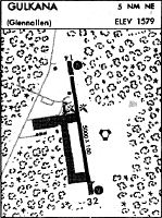
Runways
Runway Summary
| Runways: | 15L/33R 15R/33L |
| Longest Runway: | 15L/33R is 5001 ft (1524 m) long |
| Runways with an Instrument Approach: |
GKN Airport Runway Details
| Runway 15L/33R | 5001 ft x 100 ft (1524 m x 30 m) | |
| Runway Length Source: | 3RD PARTY SURVEY as of 07/19/2006 | |
| Surface: | Asphalt - Good condition - No special surface treatment | |
| Runway Edge Lights: | Medium Intensity | |
Runway 15L |
Runway 33R |
|
Elevation: |
1586.1 | 1546.0 |
Latitude: |
62-09-42.1470N | 62-08-53.5058N |
Longitude: |
145-27-23.8077W | 145-27-07.4120W |
|
Runway True Alignment: |
171 | 351 |
Glide Path Angle: |
3.0 degrees | 3.0 degrees |
Traffic Pattern: |
Left | Left |
Runway Markings Type: |
Nonprecision Instrument | Nonprecision Instrument |
Runway Markings Condition: |
Good | Good |
Object at End: |
TREES | TREES |
Object Height: |
37 | 57 |
Distance from End: |
1500 | 1914 |
Object Centerline Offset: |
171 ft. left of centerline | |
Visual Glide Slope Indicators: |
4-Box VASI On Left Side Of Runway | 4-Box VASI On Right Side Of Runway |
Threshold Crossing Height: |
49 | 29 |
| Runway 15R/33L | 2300 ft x 60 ft (701 m x 18 m) | |
| Runway Length Source: | ADO as of 09/06/2019 | |
| Surface: | Asphalt - Good condition - No special surface treatment | |
Runway 15R |
Runway 33L |
|
Elevation: |
1567.9 | 1547.4 |
Latitude: |
62-09-21.9600N | 62-08-59.5900N |
Longitude: |
145-27-30.3100W | 145-27-22.7600W |
|
Runway True Alignment: |
171 | 351 |
Glide Path Angle: |
0.0 degrees | 0.0 degrees |
Runway Markings Type: |
None | None |
Runway Markings Condition: |
Good | Good |
Object at End: |
TOWER | TREES |
Object Height: |
56 | 63 |
Object Marked/Lighted?: |
Lighted | |
Distance from End: |
880 | 1213 |
Object Centerline Offset: |
171 ft. left of centerline |
Services
Fuel Available: |
100LL, Jet A |
Parking: |
Tiedowns available |
Maps & Diagrams
GKN Sectional
Flight Planning
at skyvector.com
at skyvector.com