Location
Latitude: |
26-11-50.2057N (26.197279) |
Longitude: |
080-10-14.5426W (-80.170706) |
Elevation: |
13.4 feet MSL (4 m MSL) |
Magnetic Variation: |
7.3 W (as of April 2024 from WMM2020 model) |
Time Zone: |
UTC -5.0 (Standard Time) UTC -4.0 (Daylight Savings Time) |
From City: |
05 N.M. N of Fort Lauderdale, Florida |
Found On: |
Miami Chart |
FAA Region: |
ASO |
Contacts
Manager: |
Publicly owned: |
| RUFUS JAMES 6000 NW 21ST AVE FT LAUDERDALE, FL 33309 (954) 828-4968 |
CITY OF FORT LAUDERDALE PO BOX 14250 FORT LAUDERDALE, FL 33301 954-828-5000 |
Operations
Airport Status: |
Operational |
Facility Use: |
Public |
Type: |
Airport |
Activation Date: |
07/1944 |
Control tower: |
Yes |
Attendance (Months/Days/Hours): |
Months/Days/Hours ALL/ALL/ALL |
Boundary ARTCC: |
ZMA (Miami) |
Responsible ARTCC: |
ZMA (Miami) |
Lighting Schedule: |
SS-SR |
Segmented Circle Indicator: |
Yes, Lighted |
Traffic Pattern Altitude (MSL): |
1013 feet (309 m) |
NOTAMs Facility: |
FXE |
NOTAM-D Service: |
Yes |
International Airport of Entry: |
No |
Customs Landing Rights: |
Yes |
Military Landing Rights: |
Yes |
Civil/Military Joint Use: |
No |
Based Aircraft
| Single Engine: | 253 |
| Multi Engine: | 118 |
| Jet Engine: | 236 |
| GA Helicopters: | 22 |
| Gliders: | 1 |
| Ultralights: | 1 |
Annual Operations (as of 05/01/2018)
| Total Operations: | 149703 | |
| Air Taxi: | 12880 | 8.6% |
| GA Local: | 116520 | 77.8% |
| GA Itinerant: | 20153 | 13.5% |
| Military Aircraft: | 150 | 0.1% |
Communications
| Unicom: | 122.950 |
| Tower: | EXECUTIVE 120.9 239.3 Hrs: 24 |
| Clearance Del.: | 127.95 |
| Ground: | 121.75 |
| Approach: | MIAMI |
| Departure: | MIAMI |
| ATIS: | 119.85 Hrs: 24 |
| ASOS: | 119.85 (954-772-2537) |
- MIAMI APCH/DEP FREQS USABLE 4000' AND BELOW.
Fixed Based Operators (FBOs) & Fuel
(Click on a business for detail)
Please help us keep this information up to date. This is a FREE SERVICE just like everything else on Airport Guide! If you see that a business needs to be added, modified, or deleted please fill out our Update Form.
click here.
Please help us keep this information up to date. This is a FREE SERVICE just like everything else on Airport Guide! If you see that a business needs to be added, modified, or deleted please fill out our Update Form.
Area Code: 954 |


Flight Service Stations
| Primary | Alternate | |
| FSS on Field: | N | |
| FSS Name (ID): | Miami(MIA) | |
| Frequency: | ||
| Toll Free Phone: | 1-800-WX-BRIEF |
Instrument Procedures / Charts
FAA Terminal Procedures valid from 0901Z 03/21/24 to 0901Z 04/18/24.
There are various types of charts available for an airport. They are listed in the Page Type column. Here is a legend for those types:
APD - Airport Diagram
DP - Departure Procedure Charts
HOT - Hot Spots
IAP - Instrument Approach Procedure Charts
MIN - Minimums
STAR - Standard Terminal Arrival Charts
Terminal Procedures are only available for airports in several countries with more being added all the time. If you are looking for a specific country's charts, please send an email to support(at)airportguide.com stating the country name. This will be used to prioritize the implementation.
Navigation Aids (Navaids) near FXE
| Dist (NM) | ID | Morse Code | Name | Type | Freq | True Hdg | Mag Hdg |
|---|---|---|---|---|---|---|---|
| 6.9 | FX | . . _ . _ . . _ | Praiz | NDB | 221 | 263 | 270 |
| 7.4 | FLL | . . _ . . _ . . . _ . . | Fort Lauderdale | VOR-DME | 114.40 | 178 | 185 |
| 24.8 | MIA | _ _ . . . _ | Miami Intl | VOT | 112.00 | 193 | 200 |
| 25.7 | DHP | _ . . . . . . . _ _ . | Dolphin | VORTAC | 113.90 | 202 | 209 |
| 26.7 | VKZ | . . . _ _ . _ _ _ . . | Virginia Key | VOR-DME | 117.10 | 178 | 185 |
| 29.3 | PBI | . _ _ . _ . . . . . | Palm Beach | VORTAC | 115.70 | 8 | 15 |
| 29.6 | PBI | . _ _ . _ . . . . . | Palm Beach | VOT | 109.00 | 6 | 13 |
| 37.9 | TM | _ _ _ | Qeezy | NDB | 266 | 208 | 215 |
| 43.6 | UTX | . . _ _ _ . . _ | United | NDB | 405 | 348 | 355 |
| 43.9 | HST | . . . . . . . _ | Homestead | TACAN | 108.20 | 194 | 201 |
| 44.9 | PHK | . _ _ . . . . . _ . _ | Pahokee | VOR-DME | 115.40 | 321 | 328 |
| 49.6 | TN | _ _ . | Monry | NDB | 227 | 246 | 253 |
| 55.8 | ZBV | _ _ . . _ . . . . . . _ | Bimini | VORTAC | 116.70 | 121 | 129 |
| 75.7 | LBV | . _ . . _ . . . . . . _ | La Belle | VORTAC | 110.40 | 300 | 307 |
| 77.5 | ZFP | _ _ . . . . _ . . _ _ . | Freeport | NDB | 209 | 75 | 83 |
| 78.1 | FPR | . . _ . . _ _ . . _ . | Fort Pierce | NDB | 275 | 352 | 359 |
| 82.0 | ZFP | _ _ . . . . _ . . _ _ . | Freeport | VOR-DME | 113.20 | 74 | 82 |
| 84.1 | BHF | Islands | NDB | 326 | 74 | 82 | |
| 86.6 | CYY | _ . _ . _ . _ _ _ . _ _ | Cypress | VOR-DME | 108.60 | 268 | 275 |
| 88.6 | RSW | . _ . . . . . _ _ | Lee County | VORTAC | 114.15 | 283 | 290 |
Nearby Airports with Fuel
Notices to Airmen (NOTAMS)
Remarks
| A11 | CONTACT PERSON: RUFUS JAMES 954-828-4968 |
| A110*G | THIS AIRPORT HAS BEEN SURVEYED BY THE NATIONAL GEODETIC SURVEY. |
| A110-11 | REQUEST PROGRESSIVE TAXI IF UNFAMILIAR. |
| A110-13 | MAINTENANCE ENGINE RUN-UPS PROHIBITED 1900-0700. |
| A110-14 | RY 27 NIGHTTIME PREFERENTIAL USE RY FOR ALL ACFT DEPARTURES WHEN WINDS PERMIT. |
| A110-15 | RY 09 NIGHTTIME PREFERENTIAL USE RY FOR ALL ACFT ARRIVALS WHEN WINDS PERMIT. |
| A110-16 | NOISE ABATEMENT PROCEDURES IN EFFECT CALL AMGR 954-828-4955. |
| A110-17 | US CUSTOMS RAMP CLOSED TO ARRIVING AIRCRAFT 0000-0800. |
| A110-18 | PPR FOR ACFT IN EXCESS OF RY WEIGHT BEARING CAPACITY. CALL AMGR MON-FRI 954-828-4955. |
| A110-2 | PORTIONS OF RY 31 RUN-UP AREA(WEST OF TWY 'B')ARE NOT VISIBLE FROM THE ATCT. |
| A110-20 | CUSTOMS RAMP LOCATED TWY G7. |
| A110-22 | USE CTN FOR DRONES AUTH AOB 400 FT WI CLASS D. |
| A110-3 | FLOCKS OF BIRDS ON & INVOF ARPT. |
| A110-6 | ALL ACFT OPERATORS AVOID OVERFLIGHTS OF RESIDENTIAL AREA ONE-HALF MILE SW OF ATCT. |
| A110-8 | TAXILANE 'C'(SW OF TWY 'B') IS A NON-CONTROLLED OPERATIONAL AREA. |
| A30-13/31 | RY 13/31 CLSD 2200-0700 WHEN RY 09/27 IS OPERATIONAL FULL LENGTH. |
| E80 | US CUSTOMS AVBL 0800-2359. |
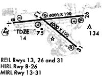
Runways
Runway Summary
| Runways: | 09/27 13/31 |
| Longest Runway: | 09/27 is 6002 ft (1829 m) long |
| Runways with an Instrument Approach: | 09 |
FXE Airport Runway Details
| Runway 09/27 | 6002 ft x 100 ft (1829 m x 30 m) | |
| Surface: | Asphalt - Good condition - Saw-cut or plastic grooved | |
| Runway Pavement Class: | 18 /F/A/X/T | |
| Runway Edge Lights: | High Intensity | |
Runway Weight Bearing Capacity (in thousands of pounds) |
||
| Single Wheel Landing Gear: | 56.0 | |
| Dual Wheel Landing Gear: | 81.0 | |
Runway 09 |
Runway 27 |
|
Elevation: |
11.7 | 11.8 |
Latitude: |
26-11-51.2684N | 26-11-57.7082N |
Longitude: |
080-10-51.1157W | 080-09-45.6114W |
|
Runway True Alignment: |
084 | 264 |
ILS Type: |
ILS | |
Glide Path Angle: |
3.0 degrees | 3.2 degrees |
Runway Markings Type: |
Precision Instrument | Precision Instrument |
Runway Markings Condition: |
Good | Good |
Object at End: |
TREE | BLDG |
Object Height: |
78 | 131 |
Object Marked/Lighted?: |
Lighted | |
Distance from End: |
4195 | 4760 |
Object Centerline Offset: |
85 ft. right of centerline | 75 ft. left of centerline |
Visual Glide Slope Indicators: |
4-Light PAPI On Left Side Of Runway | 4-Light PAPI On Left Side Of Runway |
Approach Light System: |
1,400 Foot Medium Intensity Approach Lighting System With Runway Alignment Indicator Lights | |
REIL: |
Yes | |
Threshold Crossing Height: |
56 | 56 |
| Runway 13/31 | 4000 ft x 100 ft (1219 m x 30 m) | |
| Surface: | Asphalt - Good condition - Saw-cut or plastic grooved | |
| Runway Pavement Class: | 26 /F/B/X/T | |
| Runway Edge Lights: | Medium Intensity | |
Runway Weight Bearing Capacity (in thousands of pounds) |
||
| Single Wheel Landing Gear: | 30.0 | |
| Dual Wheel Landing Gear: | 60.0 | |
Runway 13 |
Runway 31 |
|
Elevation: |
12.3 | 10.9 |
Latitude: |
26-11-56.1957N | 26-11-31.3753N |
Longitude: |
080-10-25.9242W | 080-09-51.6986W |
|
Runway True Alignment: |
129 | 309 |
Glide Path Angle: |
3.2 degrees | 3.2 degrees |
Traffic Pattern: |
Left | Left |
Runway Markings Type: |
Nonprecision Instrument | Nonprecision Instrument |
Runway Markings Condition: |
Good | Good |
Object at End: |
TREE | ROAD |
Object Height: |
36 | 13 |
Distance from End: |
1078 | 645 |
Object Centerline Offset: |
85 ft. right of centerline | 75 ft. left of centerline |
Visual Glide Slope Indicators: |
2-Light PAPI On Left Side Of Runway | 2-Light PAPI On Left Side Of Runway |
REIL: |
Yes | Yes |
Threshold Crossing Height: |
44 | 50 |
Services
Airframe Repair: |
Minor |
Powerplant Repair: |
Major |
Bottled Oxygen: |
None |
Bulk Oxygen: |
None |
Fuel Available: |
100LL, Jet A |
Landing Fees: |
No |
Parking: |
Tiedowns available |
Maps & Diagrams
FXE Sectional
Flight Planning
at skyvector.com
at skyvector.com