Location
Latitude: |
41-03-20.5914N (41.05572) |
Longitude: |
091-58-50.9585W (-91.980822) |
Elevation: |
800.9 feet MSL (244 m MSL) |
Magnetic Variation: |
0.8 W (as of April 2024 from WMM2020 model) |
Time Zone: |
UTC -6.0 (Standard Time) UTC -5.0 (Daylight Savings Time) |
From City: |
03 N.M. NW of Fairfield, Iowa |
Found On: |
Chicago Chart |
FAA Region: |
ACE |
Contacts
Manager: |
Publicly owned: |
| ROBERT LYONS 2013 AIRPORT RD FAIRFIELD, IA 52556 641-472-3166 |
CITY OF FAIRFIELD 118 SOUTH MAIN FAIRFIELD, IA 52556 641-472-6193 |
Operations
Airport Status: |
Operational |
Facility Use: |
Public |
Type: |
Airport |
Activation Date: |
05/1967 |
Control tower: |
No |
Attendance (Months/Days/Hours): |
Months/Days/Hours ALL/MON-FRI/0730-1630 |
Boundary ARTCC: |
ZAU (Chicago) |
Responsible ARTCC: |
ZAU (Chicago) |
Lighting Schedule: |
SEE RMK |
Segmented Circle Indicator: |
Yes |
Traffic Pattern Altitude (MSL): |
1801 feet (549 m) |
NOTAMs Facility: |
FFL |
NOTAM-D Service: |
Yes |
International Airport of Entry: |
No |
Customs Landing Rights: |
No |
Military Landing Rights: |
Yes |
Civil/Military Joint Use: |
No |
Based Aircraft
| Single Engine: | 17 |
| Multi Engine: | 2 |
| Jet Engine: | 1 |
Annual Operations (as of 08/10/2020)
| Total Operations: | 5000 | |
| Air Taxi: | 112 | 2.2% |
| GA Local: | 2427 | 48.5% |
| GA Itinerant: | 1998 | 40.0% |
| Military Aircraft: | 463 | 9.3% |
Communications
| CTAF: | 122.700 |
| Unicom: | 122.700 |
| AWOS-3: | 132.025 (641-472-4548) |
- APCH/DEP SVC PRVDD BY CHICAGO ARTCC ON FREQS 118.15/335.575 (OTTUMWA RCAG).
Fixed Based Operators (FBOs) & Fuel
(Click on a business for detail)
Please help us keep this information up to date. This is a FREE SERVICE just like everything else on Airport Guide! If you see that a business needs to be added, modified, or deleted please fill out our Update Form.
To add, modify, or delete a business click here.
Please help us keep this information up to date. This is a FREE SERVICE just like everything else on Airport Guide! If you see that a business needs to be added, modified, or deleted please fill out our Update Form.
Area Code: 641 |
| Business Name | Frequency | Phone | Fuel Grade |
|---|---|---|---|
| Fairfield Flying Service
Update FBO info |
472-3166, 472-0183 | 100LL, Jet A |
Flight Service Stations
| Primary | Alternate | |
| FSS on Field: | N | |
| FSS Name (ID): | Fort Dodge(FOD) | |
| Frequency: | ||
| Toll Free Phone: | 1-800-WX-BRIEF |
Instrument Procedures / Charts
FAA Terminal Procedures valid from 0901Z 03/21/24 to 0901Z 04/18/24.
There are various types of charts available for an airport. They are listed in the Page Type column. Here is a legend for those types:
APD - Airport Diagram
DP - Departure Procedure Charts
HOT - Hot Spots
IAP - Instrument Approach Procedure Charts
MIN - Minimums
STAR - Standard Terminal Arrival Charts
| Page Type | Page Name | Volume | Action Since Last Cycle |
|---|---|---|---|
| IAP | RNAV (GPS) RWY 18 | NC-3 | |
| IAP | RNAV (GPS) RWY 36 | NC-3 | |
| MIN | ALTERNATE MINIMUMS | NC-3 | |
| MIN | TAKEOFF MINIMUMS | NC-3 |
Terminal Procedures are only available for airports in several countries with more being added all the time. If you are looking for a specific country's charts, please send an email to support(at)airportguide.com stating the country name. This will be used to prioritize the implementation.
Navigation Aids (Navaids) near FFL
| Dist (NM) | ID | Morse Code | Name | Type | Freq | True Hdg | Mag Hdg |
|---|---|---|---|---|---|---|---|
| 2.7 | FFL | . . _ . . . _ . . _ . . | Fairfield | NDB | 332 | 187 | 188 |
| 15.7 | OTM | _ _ _ _ _ _ | Ottumwa | VOR-DME | 111.60 | 264 | 265 |
| 19.3 | AWG | . _ . _ _ _ _ . | Washington | NDB | 219 | 45 | 46 |
| 22.0 | MPZ | _ _ . _ _ . _ _ . . | Mount Pleasant | NDB | 212 | 106 | 107 |
| 25.1 | OOA | _ _ _ _ _ _ . _ | Oskaloosa | NDB | 414 | 294 | 295 |
| 27.6 | BEX | _ . . . . _ . . _ | Bloomfield | NDB | 269 | 227 | 228 |
| 32.4 | IOW | . . _ _ _ . _ _ | Iowa City | VOR-DME | 116.20 | 30 | 31 |
| 41.9 | DDD | _ . . _ . . _ . . | Port City | DME | 116.5 | 63 | 64 |
| 43.3 | EOK | . _ _ _ _ . _ | Keokuk | NDB | 366 | 144 | 145 |
| 45.8 | BR | _ . . . . _ . | Burns | NDB | 390 | 121 | 122 |
| 48.3 | PEA | . _ _ . . . _ | Pella | NDB | 257 | 296 | 296 |
| 50.7 | CID | _ . _ . . . _ . . | Cedar Rapids | VOR-DME | 114.10 | 9 | 10 |
| 51.8 | BRL | _ . . . . _ . . _ . . | Burlington | VOR-DME | 111.40 | 112 | 113 |
| 61.9 | IRK | . . . _ . _ . _ | Kirksville | VORTAC | 114.60 | 206 | 207 |
| 62.7 | MZV | _ _ _ _ . . . . . _ | Moline | VOR-DME | 114.40 | 74 | 75 |
| 67.0 | TNU | _ _ . . . _ | Newton | VOR-DME | 112.50 | 311 | 311 |
| 70.4 | GBG | _ _ . _ . . . _ _ . | Galesburg | DME | 109.8 | 95 | 96 |
| 71.2 | DVN | _ . . . . . _ _ . | Davenport Municipal | VOT | 111.80 | 61 | 62 |
| 72.1 | JZY | . _ _ _ _ _ . . _ . _ _ | Macomb | NDB | 251 | 116 | 117 |
| 75.8 | JWJ | . _ _ _ . _ _ . _ _ _ | Elmwood | DME | 109.4 | 326 | 327 |
Nearby Airports with Fuel
Notices to Airmen (NOTAMS)
Remarks
| A110-3 | RY 36 IS CALM WIND RY. |
| A110-4 | BIRDS ON & INVOF ARPT. |
| A110-5 | FOR CD CTC CHICAGO ARTCC AT 630-906-8921. |
| A15 | EMAIL ADDRESS: FFSLYONS@YAHOO.COM (ALL LOWER CASE) |
| A17 | ARPT UNATNDD ALL MAJOR HOLIDAYS |
| A30-08/26 | CLSD NOV-MAR. |
| A42-08 | 08/26 THRS & EDGES MARKED WITH YELLOW CONES. THR CONES HAVE RED/GREEN REFLECTOR TAPE & EDGE CONES HAVE WHITE. |
| A81-APT | ACTVT MIRL RY 18/36; PAPI AND REIL RYS 18 & 36 - CTAF. |
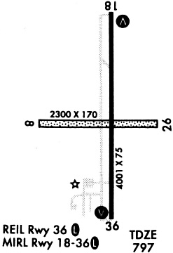
Runways
Runway Summary
| Runways: | 08/26 18/36 |
| Longest Runway: | 18/36 is 5503 ft (1677 m) long |
| Runways with an Instrument Approach: |
FFL Airport Runway Details
| Runway 08/26 | 2505 ft x 140 ft (764 m x 43 m) | |
| Runway Length Source: | 3RD PARTY SURVEY as of 12/01/2010 | |
| Surface: | Turf - Good condition - No special surface treatment | |
Runway 08 |
Runway 26 |
|
Elevation: |
792.8 | 790.3 |
Latitude: |
41-03-11.0924N | 41-03-10.9774N |
Longitude: |
091-59-12.8486W | 091-58-40.1524W |
|
Runway True Alignment: |
090 | 270 |
Glide Path Angle: |
0.0 degrees | 0.0 degrees |
Object at End: |
FENCE | FENCE |
Object Height: |
6 | 4 |
Distance from End: |
120 | 80 |
Object Centerline Offset: |
0 ft. left and right of centerline | 0 ft. left and right of centerline |
| Runway 18/36 | 5503 ft x 100 ft (1677 m x 30 m) | |
| Runway Length Source: | 3RD PARTY SURVEY as of 12/01/2010 | |
| Surface: | Turf - Good condition - No special surface treatment | |
| Runway Pavement Class: | 16 /R/C/W/T | |
| Runway Edge Lights: | Medium Intensity | |
Runway Weight Bearing Capacity (in thousands of pounds) |
||
| Single Wheel Landing Gear: | 30.0 | |
| Dual Wheel Landing Gear: | 45.0 | |
Runway 18 |
Runway 36 |
|
Elevation: |
797.2 | 791.6 |
Latitude: |
41-03-52.1252N | 41-02-57.7580N |
Longitude: |
091-58-48.6741W | 091-58-48.1975W |
|
Runway True Alignment: |
180 | 360 |
Glide Path Angle: |
3.0 degrees | 3.0 degrees |
Traffic Pattern: |
Left | Left |
Runway Markings Type: |
Nonprecision Instrument | Nonprecision Instrument |
Runway Markings Condition: |
Good | Good |
Object at End: |
ROAD | |
Object Height: |
17 | |
Distance from End: |
1054 | |
Object Centerline Offset: |
0 ft. left and right of centerline | 0 ft. left and right of centerline |
Visual Glide Slope Indicators: |
4-Light PAPI On Left Side Of Runway | 4-Light PAPI On Left Side Of Runway |
REIL: |
Yes | Yes |
Threshold Crossing Height: |
40 | 40 |
Services
Airframe Repair: |
Major |
Powerplant Repair: |
Major |
Bottled Oxygen: |
None |
Bulk Oxygen: |
None |
Fuel Available: |
100LL, Jet A, MOGAS |
Landing Fees: |
No |
Parking: |
Hangars and tiedowns available |
Maps & Diagrams
FFL Sectional
Flight Planning
at skyvector.com
at skyvector.com