Location
Latitude: |
41-16-29.2000N (41.274778) |
Longitude: |
111-02-04.7000W (-111.034639) |
Elevation: |
7142.5 feet MSL (2177 m MSL) |
Magnetic Variation: |
10.6 E (as of April 2024 from WMM2020 model) |
Time Zone: |
UTC -7.0 (Standard Time) UTC -6.0 (Daylight Savings Time) |
From City: |
03 N.M. W of Evanston, Wyoming |
Found On: |
Salt Lake City Chart |
FAA Region: |
ANM |
Contacts
Manager: |
Publicly owned: |
| MIKE LASALLE PO BOX 756 EVANSTON, WY 82931 307-789-2256 |
CITY OF EVANSTON 1200 MAIN ST EVANSTON, WY 82930 (307) 783-0318 |
Operations
Airport Status: |
Operational |
Facility Use: |
Public |
Type: |
Airport |
Activation Date: |
03/1985 |
Control tower: |
No |
Attendance (Months/Days/Hours): |
Months/Days/Hours ALL/ALL/0700-1900 |
Boundary ARTCC: |
ZLC (Salt Lake City) |
Responsible ARTCC: |
ZLC (Salt Lake City) |
Lighting Schedule: |
SEE RMK |
Segmented Circle Indicator: |
Yes |
Traffic Pattern Altitude (MSL): |
8142 feet (2482 m) |
NOTAMs Facility: |
EVW |
NOTAM-D Service: |
Yes |
Based Aircraft
| Single Engine: | 18 |
| Multi Engine: | 2 |
| Jet Engine: | 3 |
Annual Operations (as of 06/30/2022)
| Total Operations: | 5506 | |
| Air Taxi: | 100 | 1.8% |
| GA Local: | 1100 | 20.0% |
| GA Itinerant: | 4200 | 76.3% |
| Military Aircraft: | 106 | 1.9% |
Communications
| CTAF: | 123.000 |
| Unicom: | 123.000 |
| ASOS: | 120.0 (307-789-0585) |
- APCH/DEP CTL SVC PRVDD BY SALT LAKE ARTCC ( ZLC) ON FREQS 127.7/354.125 (FRANCIS PEAK RCAG).
Fixed Based Operators (FBOs) & Fuel
(Click on a business for detail)
Please help us keep this information up to date. This is a FREE SERVICE just like everything else on Airport Guide! If you see that a business needs to be added, modified, or deleted please fill out our Update Form.
To add, modify, or delete a business click here.
Please help us keep this information up to date. This is a FREE SERVICE just like everything else on Airport Guide! If you see that a business needs to be added, modified, or deleted please fill out our Update Form.
Area Code: 307 |
| Business Name | Frequency | Phone | Fuel Grade |
|---|---|---|---|
| Star West Aviation
Update FBO info |
Unicom 122.8 | 800-789-2256 | 100LL, Jet A |
Flight Service Stations
| Primary | Alternate | |
| FSS on Field: | N | |
| FSS Name (ID): | Casper(CPR) | |
| Frequency: | ||
| Toll Free Phone: | 1-800-WX-BRIEF |
Instrument Procedures / Charts
FAA Terminal Procedures valid from 0901Z 03/21/24 to 0901Z 04/18/24.
There are various types of charts available for an airport. They are listed in the Page Type column. Here is a legend for those types:
APD - Airport Diagram
DP - Departure Procedure Charts
HOT - Hot Spots
IAP - Instrument Approach Procedure Charts
MIN - Minimums
STAR - Standard Terminal Arrival Charts
| Page Type | Page Name | Volume | Action Since Last Cycle |
|---|---|---|---|
| IAP | ILS OR LOC/DME RWY 23 | NW-1 | |
| IAP | RNAV (GPS) RWY 05 | NW-1 | |
| IAP | RNAV (GPS) RWY 23 | NW-1 | |
| IAP | VOR/DME RWY 05 | NW-1 | |
| MIN | ALTERNATE MINIMUMS | NW-1 | |
| MIN | TAKEOFF MINIMUMS | NW-1 | |
| ODP | FORT BRIDGER ONE (OBSTACLE) | NW-1 |
Terminal Procedures are only available for airports in several countries with more being added all the time. If you are looking for a specific country's charts, please send an email to support(at)airportguide.com stating the country name. This will be used to prioritize the implementation.
Navigation Aids (Navaids) near EVW
| Dist (NM) | ID | Morse Code | Name | Type | Freq | True Hdg | Mag Hdg |
|---|---|---|---|---|---|---|---|
| 0.6 | EVW | . . . . _ . _ _ | Evanston | VOR-DME | 109.60 | 256 | 245 |
| 28.2 | FBR | . . _ . _ . . . . _ . | Fort Bridger | VOR-DME | 114.45 | 77 | 67 |
| 43.0 | HIF | . . . . . . . . _ . | Hill | TACAN | 111.20 | 257 | 246 |
| 48.1 | OGD | _ _ _ _ _ . _ . . | Ogden | VORTAC | 115.70 | 266 | 255 |
| 49.1 | BMC | _ . . . _ _ _ . _ . | Brigham City | NDB | 294 | 287 | 276 |
| 49.9 | TCH | _ _ . _ . . . . . | Wasatch | VORTAC | 116.80 | 239 | 228 |
| 52.0 | SLC | . . . . _ . . _ . _ . | Salt Lake City | VOT | 111.00 | 234 | 223 |
| 53.7 | LHO | . _ . . . . . . _ _ _ | Brigham City | VOR-DME | 112.90 | 305 | 294 |
| 70.8 | PVU | . _ _ . . . . _ . . _ | Provo | VOR-DME | 108.40 | 206 | 195 |
| 71.6 | TVY | _ . . . _ _ . _ _ | Tooele | NDB | 371 | 236 | 225 |
| 72.8 | FFU | . . _ . . . _ . . . _ | Fairfield | VORTAC | 116.60 | 214 | 203 |
| 79.2 | MTU | _ _ _ . . _ | Myton | VOR-DME | 112.70 | 148 | 138 |
| 84.3 | MLD | _ _ . _ . . _ . . | Malad City | VOR-DME | 117.40 | 311 | 300 |
| 88.2 | VEL | . . . _ . . _ . . | Vernal | VOR-DME | 108.20 | 127 | 117 |
| 88.5 | BPI | _ . . . . _ _ . . . | Big Piney | VOR-DME | 116.50 | 27 | 16 |
| 92.8 | OCS | _ _ _ _ . _ . . . . | Rock Springs | VOR-DME | 116.00 | 77 | 67 |
Nearby Airports with Fuel
Notices to Airmen (NOTAMS)
Remarks
| A11 | COUNTY OF UINTA. |
| A110-4 | GCO AVBL ON FREQ 121.72 THRU SALT LAKE ARTCC CD, CASPER FSS NOT AVBL. |
| A110-5 | FOR CD IF UNA VIA GCO CTC SALT LAKE ARTCC AT 801-320-2568. |
| A17 | FOR SVC AFT HRS CALL 1-307-789-2256. |
| A75 | ARPT CHRGS FAC FEE. |
| A81-APT | ACTVT MALSR RWY 23; REIL RWY 05; PAPI RWY 05 & 23; HIRL RWY 05/23 - CTAF. |
| E111 | DETERMINATION PENDING. |
Runways
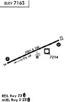
Runway Summary
| Runways: | 05/23 |
| Longest Runway: | 05/23 is 7300 ft (2225 m) long |
| Runways with an Instrument Approach: | 23 |
EVW Airport Runway Details
| Runway 05/23 | 7300 ft x 100 ft (2225 m x 30 m) | |
| Runway Length Source: | 3RD PARTY SURVEY as of 08/23/2005 | |
| Surface: | Asphalt - Good condition - Saw-cut or plastic grooved | |
| Runway Edge Lights: | High Intensity | |
Runway Weight Bearing Capacity (in thousands of pounds) |
||
| Single Wheel Landing Gear: | 30.0 | |
| Dual Wheel Landing Gear: | 70.0 | |
Runway 05 |
Runway 23 |
|
Elevation: |
7134.9 | 7136.4 |
Latitude: |
41-16-15.0224N | 41-16-43.4660N |
Longitude: |
111-02-48.5776W | 111-01-20.7568W |
|
Runway True Alignment: |
066 | 246 |
ILS Type: |
ILS/DME | |
Glide Path Angle: |
3.0 degrees | 3.0 degrees |
Runway Markings Type: |
Precision Instrument | Precision Instrument |
Runway Markings Condition: |
Good | Good |
Visual Glide Slope Indicators: |
4-Light PAPI On Left Side Of Runway | 4-Light PAPI On Left Side Of Runway |
Approach Light System: |
1,400 Foot Medium Intensity Approach Lighting System With Runway Alignment Indicator Lights | |
REIL: |
Yes | No |
Threshold Crossing Height: |
45 | 44 |
Services
Airframe Repair: |
Major |
Powerplant Repair: |
Major |
Bulk Oxygen: |
High Pressure / Low Pressure |
Fuel Available: |
100LL, Jet A |
Landing Fees: |
No |
Parking: |
Hangars and tiedowns available |
Maps & Diagrams
EVW Sectional
Flight Planning
at skyvector.com
at skyvector.com