Location
Latitude: |
31-17-59.0000N (31.299722) |
Longitude: |
085-53-59.4000W (-85.899833) |
Elevation: |
360.9 feet MSL (110 m MSL) |
Magnetic Variation: |
4.3 W (as of April 2024 from WMM2020 model) |
Time Zone: |
UTC -6.0 (Standard Time) UTC -5.0 (Daylight Savings Time) |
From City: |
03 N.M. W of Enterprise, Alabama |
Found On: |
New Orleans Chart |
FAA Region: |
ASO |
Contacts
Manager: |
Publicly owned: |
| BARRY MOTT 863 AVIATION BLVD. ENTERPRISE, AL 36330 334-348-2676 |
TOWN OF ENTERPRISE P.O.BOX 311000 ENTERPRISE, AL 36330 334-348-2671 |
Operations
Airport Status: |
Operational |
Facility Use: |
Public |
Type: |
Airport |
Activation Date: |
07/1955 |
Control tower: |
No |
Attendance (Months/Days/Hours): |
Months/Days/Hours ALL/MONDAY - FRIDAY/0700 - 1700 |
Boundary ARTCC: |
ZJX (Jacksonville) |
Responsible ARTCC: |
ZJX (Jacksonville) |
Lighting Schedule: |
SEE RMK |
Segmented Circle Indicator: |
Yes |
Traffic Pattern Altitude (MSL): |
1361 feet (415 m) |
NOTAMs Facility: |
ANB |
NOTAM-D Service: |
Yes |
International Airport of Entry: |
No |
Customs Landing Rights: |
No |
Military Landing Rights: |
Yes |
Civil/Military Joint Use: |
No |
Based Aircraft
| Single Engine: | 46 |
| Multi Engine: | 1 |
| GA Helicopters: | 1 |
Annual Operations (as of 08/14/2019)
| Total Operations: | 43456 | |
| Air Taxi: | 36 | 0.1% |
| GA Local: | 4320 | 9.9% |
| GA Itinerant: | 14100 | 32.4% |
| Military Aircraft: | 25000 | 57.5% |
Communications
| CTAF: | 122.800 |
| Unicom: | 122.800 |
| Approach: | CAIRNS 133.45 133.45 JAX ARTCC |
| Departure: | CAIRNS 133.45 133.45 JAX ARTCC |
| AWOS-3PT: | 118.9 (334-347-3524) |
- APCH/DEP SVC PRVDD BY JACKSONVILLE ARTCC ON FREQS 134.3/322.55 (DOTHAN RCAG) WHEN CAIRNS APCH/DEP CLSD.
Fixed Based Operators (FBOs) & Fuel
(Click on a business for detail)
Please help us keep this information up to date. This is a FREE SERVICE just like everything else on Airport Guide! If you see that a business needs to be added, modified, or deleted please fill out our Update Form.
To add, modify, or delete a business click here.
Please help us keep this information up to date. This is a FREE SERVICE just like everything else on Airport Guide! If you see that a business needs to be added, modified, or deleted please fill out our Update Form.
Area Code: 334 |
| Business Name | Frequency | Phone | Fuel Grade |
|---|---|---|---|
| Aircrafters of Enterprise
Update FBO info |
347-7171 | ||
| City of Enterprise
Update FBO info |
Unicom 122.8 | 347-1211 ext. 316 | 100LL |
| Enterprise Aviation
Update FBO info |
393-7727 | 100LL |
Flight Service Stations
| Primary | Alternate | |
| FSS on Field: | N | |
| FSS Name (ID): | Anniston(ANB) | |
| Frequency: | ||
| Toll Free Phone: | 1-800-WX-BRIEF |
Instrument Procedures / Charts
FAA Terminal Procedures valid from 0901Z 03/21/24 to 0901Z 04/18/24.
There are various types of charts available for an airport. They are listed in the Page Type column. Here is a legend for those types:
APD - Airport Diagram
DP - Departure Procedure Charts
HOT - Hot Spots
IAP - Instrument Approach Procedure Charts
MIN - Minimums
STAR - Standard Terminal Arrival Charts
| Page Type | Page Name | Volume | Action Since Last Cycle |
|---|---|---|---|
| IAP | RNAV (GPS) RWY 05 | SE-4 | |
| IAP | VOR RWY 05 | SE-4 | |
| MIN | TAKEOFF MINIMUMS | SE-4 |
Terminal Procedures are only available for airports in several countries with more being added all the time. If you are looking for a specific country's charts, please send an email to support(at)airportguide.com stating the country name. This will be used to prioritize the implementation.
Navigation Aids (Navaids) near ETS
| Dist (NM) | ID | Morse Code | Name | Type | Freq | True Hdg | Mag Hdg |
|---|---|---|---|---|---|---|---|
| 0.2 | EDN | . _ . . _ . | Enterprise | VOR | 116.60 | 216 | 220 |
| 4.8 | BVG | _ . . . . . . _ _ _ . | Boll Weevil | NDB | 352 | 299 | 303 |
| 6.2 | OZ | _ _ _ _ _ . . | Brynt | NDB | 212 | 135 | 139 |
| 8.8 | LOR | . _ . . _ _ _ . _ . | Lowe | NDB | 269 | 65 | 69 |
| 9.1 | OZR | _ _ _ _ _ . . . _ . | Cairns | VOR-DME | 111.20 | 101 | 105 |
| 13.4 | HYE | . . . . _ . _ _ . | Hanchey | NDB | 221 | 69 | 73 |
| 13.4 | HEY | . . . . . _ . _ _ | Hanchey | VOR | 110.60 | 70 | 74 |
| 24.0 | RRS | . _ . . _ . . . . | Wiregrass | VORTAC | 111.60 | 92 | 96 |
| 25.2 | JUY | . _ _ _ . . _ _ . _ _ | Judd | NDB | 264 | 270 | 274 |
| 31.0 | BKK | _ . . . _ . _ _ . _ | Tri County | NDB | 275 | 150 | 154 |
| 33.6 | TOI | _ _ _ _ . . | Blood | NDB | 365 | 341 | 345 |
| 42.3 | CE | _ . _ . . | Kobra | NDB | 201 | 230 | 234 |
| 43.1 | SMY | . . . _ _ _ . _ _ | Soyya | NDB | 329 | 126 | 131 |
| 49.1 | CEW | _ . _ . . . _ _ | Crestview | VORTAC | 115.90 | 234 | 238 |
| 50.4 | MAI | _ _ . _ . . | Marianna | VORTAC | 114.00 | 127 | 132 |
| 55.4 | EUF | . . . _ . . _ . | Eufaula | VORTAC | 109.20 | 44 | 49 |
| 56.1 | IWJ | . . . _ _ . _ _ _ | Blaak | NDB | 344 | 80 | 85 |
| 58.7 | PFN | . _ _ . . . _ . _ . | Lynne | NDB | 278 | 174 | 178 |
| 58.8 | DWG | _ . . . _ _ _ _ . | Warrington | TACAN | 134.50 | 213 | 217 |
| 59.4 | MGM | _ _ _ _ . _ _ | Montgomery | VORTAC | 112.10 | 338 | 342 |
Nearby Airports with Fuel
Notices to Airmen (NOTAMS)
Remarks
| A110-1 | FOR CD CTC CAIRNS APCH AT 334-255-8402, WHEN APCH CLSD CTC JACKSONVILLE ARTCC AT 904-845-1592. |
| A16 | ADDL PHONE 334-348-2673; AFT HRS 334-406-7676. |
| A81-APT | REIL RWY 05 & 23; PAPI RWY 05 & 23; MIRL RWY 5/23 OPER DUSK-2330; AFTER 2330 ACTVT - CTAF. |
| E111 | EXISTED PRIOR TO MAY 15, 1959. |
| E147 | 800 FT AGL FOR CAT A AND B ACFT, 1500 FT AGL FOR CAT C ACFT. |
Runways
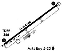
Runway Summary
| Runways: | 05/23 |
| Longest Runway: | 05/23 is 5080 ft (1548 m) long |
| Runways with an Instrument Approach: |
ETS Airport Runway Details
| Runway 05/23 | 5080 ft x 100 ft (1548 m x 30 m) | |
| Runway Length Source: | 3RD PARTY SURVEY as of 07/25/2007 | |
| Surface: | Asphalt - Good condition - No special surface treatment | |
| Runway Edge Lights: | Medium Intensity | |
Runway 05 |
Runway 23 |
|
Elevation: |
342.4 | 353.2 |
Latitude: |
31-17-43.4677N | 31-18-14.4952N |
Longitude: |
085-54-22.4752W | 085-53-36.4100W |
|
Runway True Alignment: |
052 | 232 |
Glide Path Angle: |
3.0 degrees | 3.5 degrees |
Traffic Pattern: |
Left | Left |
Runway Markings Type: |
Nonprecision Instrument | Nonprecision Instrument |
Runway Markings Condition: |
Good | Fair |
Object at End: |
TREES | POLE |
Object Height: |
29 | 65 |
Distance from End: |
422 | 1525 |
Object Centerline Offset: |
210 ft. left of centerline | 181 ft. left of centerline |
Visual Glide Slope Indicators: |
2-Light PAPI On Left Side Of Runway | 2-Light PAPI On Left Side Of Runway |
REIL: |
Yes | Yes |
Threshold Crossing Height: |
50 | 58 |
Services
Airframe Repair: |
Major |
Powerplant Repair: |
Major |
Bottled Oxygen: |
None |
Bulk Oxygen: |
None |
Fuel Available: |
100LL, Jet A-1+ |
Landing Fees: |
No |
Parking: |
Tiedowns available |
Maps & Diagrams
ETS Sectional
Flight Planning
at skyvector.com
at skyvector.com