Location
Latitude: |
32-20-14.8000N (32.337444) |
Longitude: |
104-15-48.1000W (-104.263361) |
Elevation: |
3294.6 feet MSL (1004 m MSL) |
Magnetic Variation: |
6.6 E (as of April 2024 from WMM2020 model) |
Time Zone: |
UTC -7.0 (Standard Time) UTC -6.0 (Daylight Savings Time) |
From City: |
05 N.M. SW of Carlsbad, New Mexico |
Found On: |
Albuquerque Chart |
FAA Region: |
ASW |
Contacts
Manager: |
Publicly owned: |
| CARI PICKENS 101 NORTH HALAGUENO ST CARLSBAD, NM 88220 575-887-3060 |
CITY OF CARLSBAD 101 NORTH HALAGUENO ST CARLSBAD, NM 88220 575-887-1191 |
Operations
Airport Status: |
Operational |
Facility Use: |
Public |
Type: |
Airport |
Activation Date: |
04/1941 |
Control tower: |
No |
Attendance (Months/Days/Hours): |
Months/Days/Hours ALL/MON-FRI/0600-2000 |
Boundary ARTCC: |
ZAB (Albuquerque) |
Responsible ARTCC: |
ZAB (Albuquerque) |
Lighting Schedule: |
SEE RMK |
Segmented Circle Indicator: |
Yes |
Traffic Pattern Altitude (MSL): |
4295 feet (1309 m) |
NOTAMs Facility: |
CNM |
NOTAM-D Service: |
Yes |
International Airport of Entry: |
No |
Customs Landing Rights: |
No |
Military Landing Rights: |
Yes |
Civil/Military Joint Use: |
No |
Aircraft Rescue and Firefighting: |
Class II ARFF Index: A Air Carrier Service: Scheduled Certification Date: 07/1998 |
Based Aircraft
| Single Engine: | 21 |
| Multi Engine: | 5 |
| Jet Engine: | 1 |
| GA Helicopters: | 2 |
Annual Operations (as of 12/31/2019)
| Total Operations: | 8649 | |
| Commercial: | 5224 | 60.4% |
| GA Local: | 3175 | 36.7% |
| Military Aircraft: | 250 | 2.9% |
Communications
| CTAF: | 123.000 |
| Unicom: | 123.000 |
| ASOS: | 118.375 (575-887-6858) |
- APCH/DEP SVC PRVDD BY ALBUQUERQUE ARTCC (ABQ) ON FREQS 135.875/292.15 (CARLSBAD RCAG).
Fixed Based Operators (FBOs) & Fuel
(Click on a business for detail)
Please help us keep this information up to date. This is a FREE SERVICE just like everything else on Airport Guide! If you see that a business needs to be added, modified, or deleted please fill out our Update Form.
To add, modify, or delete a business click here.
Please help us keep this information up to date. This is a FREE SERVICE just like everything else on Airport Guide! If you see that a business needs to be added, modified, or deleted please fill out our Update Form.
Area Code: 505 |
| Business Name | Frequency | Phone | Fuel Grade |
|---|---|---|---|
| McCausland Aviation
Update FBO info |
Unicom 122.95 | 885-5236 | 100LL, Jet A |
Flight Service Stations
| Primary | Alternate | |
| FSS on Field: | N | |
| FSS Name (ID): | Albuquerque(ABQ) | |
| Frequency: | ||
| Toll Free Phone: | 1-800-WX-BRIEF |
Instrument Procedures / Charts
FAA Terminal Procedures valid from 0901Z 03/21/24 to 0901Z 04/18/24.
There are various types of charts available for an airport. They are listed in the Page Type column. Here is a legend for those types:
APD - Airport Diagram
DP - Departure Procedure Charts
HOT - Hot Spots
IAP - Instrument Approach Procedure Charts
MIN - Minimums
STAR - Standard Terminal Arrival Charts
| Page Type | Page Name | Volume | Action Since Last Cycle |
|---|---|---|---|
| APD | AIRPORT DIAGRAM | SW-1 | Changed |
| IAP | ILS RWY 03 | SW-1 | Changed |
| IAP | RNAV (GPS) RWY 03 | SW-1 | Changed |
| IAP | RNAV (GPS) RWY 14R | SW-1 | Changed |
| IAP | RNAV (GPS) RWY 21 | SW-1 | Changed |
| IAP | RNAV (GPS) RWY 32L | SW-1 | Changed |
| IAP | VOR RWY 32L | SW-1 | Changed |
| MIN | ALTERNATE MINIMUMS | SW-1 | |
| MIN | TAKEOFF MINIMUMS | SW-1 |
Terminal Procedures are only available for airports in several countries with more being added all the time. If you are looking for a specific country's charts, please send an email to support(at)airportguide.com stating the country name. This will be used to prioritize the implementation.
Navigation Aids (Navaids) near CNM
| Dist (NM) | ID | Morse Code | Name | Type | Freq | True Hdg | Mag Hdg |
|---|---|---|---|---|---|---|---|
| 5.2 | CNM | _ . _ . _ . _ _ | Carlsbad | VORTAC | 116.30 | 158 | 151 |
| 5.7 | CV | _ . _ . . . . _ | Carlz | NDB | 402 | 221 | 214 |
| 32.5 | ATS | . _ _ . . . | Artesia | NDB | 414 | 342 | 335 |
| 53.4 | HOB | . . . . _ _ _ _ . . . | Hobbs | VORTAC | 111.00 | 70 | 64 |
| 54.0 | PIO | . _ _ . . . _ _ _ | Pinon | VOR-DME | 110.40 | 282 | 275 |
| 54.8 | SFL | . . . . . _ . . _ . . | Salt Flat | VORTAC | 113.00 | 230 | 223 |
| 58.8 | INK | . . _ . _ . _ | Wink | VORTAC | 112.10 | 117 | 111 |
| 62.3 | RO | . _ . _ _ _ | Topan | NDB | 305 | 351 | 344 |
| 62.7 | CME | _ . _ . _ _ . | Chisum | VORTAC | 116.10 | 343 | 336 |
| 62.8 | PEQ | . _ _ . . _ _ . _ | Pecos | VOR-DME | 116.50 | 145 | 139 |
| 73.1 | HUP | . . . . . . _ . _ _ . | Hudspeth | VORTAC | 115.00 | 231 | 224 |
| 79.5 | XAA | _ . . _ . _ . _ | Kent | NDB | 225 | 177 | 170 |
| 81.1 | VHN | . . . _ . . . . _ . | Van Horn | NDB | 233 | 199 | 192 |
| 84.3 | GNC | _ _ . _ . _ . _ . | Gaines County | NDB | 344 | 75 | 69 |
| 89.9 | CEP | _ . _ . . . _ _ . | Capitan | NDB | 278 | 320 | 313 |
| 93.1 | BWS | _ . . . . _ _ . . . | Boles | DME | 113.65 | 288 | 281 |
| 98.5 | HMN | . . . . _ _ _ . | Holloman | TACAN | 114.50 | 289 | 282 |
Nearby Airports with Fuel
| Dist (NM) | Name (Airport IDs) | True Hdg | Mag Hdg | Fuel Grade |
|---|---|---|---|---|
| 32.6 | Artesia Municipal Airport (ATS KATS ATS) |
341 | 334 | 100LL, Jet A-1 |
| 56.9 | Lea County Regional Airport (HOB KHOB HOB) |
68 | 62 | 100LL, Jet A |
| 59.3 | Roswell Air Center Airport (ROW KROW ROW) |
346 | 339 | 100LL, Jet A, Jet A-1+ |
| 63.5 | Winkler County Airport (INK KINK INK) |
121 | 115 | 100LL, Jet A+ |
| 69.0 | Pecos Municipal Airport (PEQ KPEQ PEQ) |
146 | 140 | 100LL, Jet A-1+ |
| 81.2 | Culberson County Airport (VHN KVHN VHN) |
199 | 192 | 100LL, Jet A-1+ |
| 82.5 | Roy Hurd Meml Airport (MIF E01) |
122 | 116 | 100LL, Jet A |
| 84.0 | Gaines County Airport (KGNC GNC) |
75 | 69 | 100LL, Jet A |
| 87.9 | Andrews County Airport (E11) |
89 | 83 | 100LL, Jet A |
| 92.4 | Alamogordo-White Sands Regional Airport (ALM KALM ALM) |
289 | 282 | 100LL, Jet A-1+ |
| 92.8 | Sierra Blanca Regional Airport (RUI KSRR SRR) |
316 | 309 | 100LL, Jet A |
| 98.5 | Odessa-Schlemeyer Field Airport (KODO ODO) |
104 | 98 | 100LL, Jet A |
Notices to Airmen (NOTAMS)
Remarks
| A110-3 | OIL DERRICKS INVOF ARPT. |
| A110-4 | FOR CD IF UNA TO CTC ON FSS FREQ, CTC ALBUQUERQUE ARTCC AT 505-856-4561. |
| A17 | SFC COND UNMTD MON-FRI 2200-1200 UTC (1500-0500 LOCAL) AND SAT-SUN 2030-1200 UTC (1330-0500 LOCAL). |
| A26 | ACR OPS MORE THAN 30 PAX SEATS 24 HR PPR - AMGR. |
| A30-14L/32R | ACR OPS NA. |
| A57-32L | APCH SLOPE 50:1 FM DTHR. |
| A57-32R | APCH SLOPE 38:1 FM DTHR. |
| A70-FUEL-10 | 0LL FUEL AFT HR & WKEND - 575-887-1500. |
| A81-APT | ACTVT MALSR RWY 03; MIRL RWY 03/21, 08/26 & 14R/32L - CTAF. MALSR RWY 03 & MIRL RWY 03/21, 08/26, 14R/32L PRESET LOW INTST; INCR INTST - CTAF. |
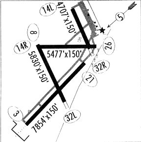
Runways
Runway Summary
| Runways: | 03/21 08/26 14L/32R 14R/32L |
| Longest Runway: | 03/21 is 7854 ft (2394 m) long |
| Runways with an Instrument Approach: | 03 |
CNM Airport Runway Details
| Runway 03/21 | 7854 ft x 150 ft (2394 m x 46 m) | |
| Runway Length Source: | 3RD PARTY SURVEY as of 04/21/2010 | |
| Surface: | Asphalt - Good condition - Porous friction course | |
| Runway Pavement Class: | 20 /F/D/X/T | |
| Runway Edge Lights: | Medium Intensity | |
Runway Weight Bearing Capacity (in thousands of pounds) |
||
| Single Wheel Landing Gear: | 62.0 | |
| Dual Wheel Landing Gear: | 88.0 | |
| Dual Tandem Wheel Landing Gear: | 140.0 | |
Runway 03 |
Runway 21 |
|
Elevation: |
3294.5 | 3247.4 |
Latitude: |
32-19-21.5379N | 32-20-17.2939N |
Longitude: |
104-16-27.3442W | 104-15-23.5982W |
|
Runway True Alignment: |
044 | 224 |
ILS Type: |
ILS | |
Glide Path Angle: |
0.0 degrees | 3.0 degrees |
Traffic Pattern: |
Left | Left |
Runway Markings Type: |
Precision Instrument | Nonprecision Instrument |
Runway Markings Condition: |
Poor | Poor |
Object at End: |
ROAD | ROAD |
Object Height: |
24 | 14 |
Distance from End: |
1080 | 388 |
Object Centerline Offset: |
623 ft. left of centerline | 514 ft. left of centerline |
Visual Glide Slope Indicators: |
4-Box VASI On Left Side Of Runway | |
Approach Light System: |
1,400 Foot Medium Intensity Approach Lighting System With Runway Alignment Indicator Lights | |
REIL: |
No | |
Threshold Crossing Height: |
58 | |
Declared Distances |
||
Take Off Run Avbl. (TORA): |
7854 | 7854 |
Take Off Distance Avbl. (TODA): |
7854 | 7854 |
Actual Stop Dist. Avbl. (ASDA): |
7504 | 7854 |
Landing Dist. Avbl. (LDA): |
7504 | 7854 |
| Runway 08/26 | 5334 ft x 75 ft (1626 m x 23 m) | |
| Runway Length Source: | 3RD PARTY SURVEY as of 04/21/2010 | |
| Surface: | Asphalt - Good condition - No special surface treatment | |
| Runway Pavement Class: | 9 /F/C/Y/T | |
| Runway Edge Lights: | Medium Intensity | |
Runway Weight Bearing Capacity (in thousands of pounds) |
||
| Single Wheel Landing Gear: | 19.0 | |
Runway 08 |
Runway 26 |
|
Elevation: |
3269.8 | 3238.8 |
Latitude: |
32-20-32.2640N | 32-20-32.2450N |
Longitude: |
104-16-14.6115W | 104-15-12.4537W |
|
Runway True Alignment: |
090 | 270 |
Glide Path Angle: |
0.0 degrees | 0.0 degrees |
Traffic Pattern: |
Left | Left |
Runway Markings Type: |
Basic | Basic |
Runway Markings Condition: |
Good | Good |
Object at End: |
ROAD | FENCE |
Object Height: |
15 | 4 |
Distance from End: |
310 | 200 |
Object Centerline Offset: |
623 ft. left of centerline | 514 ft. left of centerline |
Declared Distances |
||
Take Off Run Avbl. (TORA): |
5334 | 5334 |
Take Off Distance Avbl. (TODA): |
5334 | 5334 |
Actual Stop Dist. Avbl. (ASDA): |
5334 | 5334 |
Landing Dist. Avbl. (LDA): |
5334 | 5334 |
| Runway 14L/32R | 4616 ft x 150 ft (1407 m x 46 m) | |
| Runway Length Source: | 3RD PARTY SURVEY as of 04/21/2010 | |
| Surface: | Asphalt - Good condition - No special surface treatment | |
| Runway Pavement Class: | 4 /F/D/Y/T | |
Runway Weight Bearing Capacity (in thousands of pounds) |
||
| Single Wheel Landing Gear: | 8.0 | |
| Dual Wheel Landing Gear: | 12.5 | |
Runway 14L |
Runway 32R |
|
Elevation: |
3240.6 | 3241.3 |
Latitude: |
32-21-06.6718N | 32-20-24.8858N |
Longitude: |
104-15-36.2946W | 104-15-14.5844W |
|
Runway True Alignment: |
156 | 336 |
Glide Path Angle: |
0.0 degrees | 0.0 degrees |
Traffic Pattern: |
Left | Right |
Runway Markings Type: |
Basic | Basic |
Runway Markings Condition: |
Good | Good |
Object at End: |
ROAD | |
Object Height: |
15 | |
Distance from End: |
230 | |
Object Centerline Offset: |
623 ft. left of centerline | 514 ft. left of centerline |
Threshold Elevation: |
3241.6 | |
Displaced Threshold: |
615 | |
Threshold Latitude: |
32-20-30.4573N | |
Threshold Longitude: |
104-15-17.4788W | |
Declared Distances |
||
Take Off Run Avbl. (TORA): |
4615 | 4615 |
Take Off Distance Avbl. (TODA): |
4615 | 4615 |
Actual Stop Dist. Avbl. (ASDA): |
4615 | 4615 |
Landing Dist. Avbl. (LDA): |
4615 | 3999 |
| Runway 14R/32L | 5837 ft x 100 ft (1779 m x 30 m) | |
| Runway Length Source: | 3RD PARTY SURVEY as of 04/21/2010 | |
| Surface: | Asphalt - Good condition - No special surface treatment | |
| Runway Pavement Class: | 9 /F/D/X/T | |
| Runway Edge Lights: | Medium Intensity | |
Runway Weight Bearing Capacity (in thousands of pounds) |
||
| Single Wheel Landing Gear: | 30.0 | |
| Dual Wheel Landing Gear: | 45.0 | |
Runway 14R |
Runway 32L |
|
Elevation: |
3269.3 | 3266.8 |
Latitude: |
32-20-34.4087N | 32-19-42.4885N |
Longitude: |
104-16-15.0957W | 104-15-45.3058W |
|
Runway True Alignment: |
154 | 334 |
Glide Path Angle: |
3.0 degrees | 3.0 degrees |
Traffic Pattern: |
Right | Left |
Runway Markings Type: |
Nonprecision Instrument | Nonprecision Instrument |
Runway Markings Condition: |
Good | Good |
Object at End: |
ROAD | ROAD |
Object Height: |
7 | 15 |
Distance from End: |
300 | 672 |
Object Centerline Offset: |
623 ft. left of centerline | 514 ft. left of centerline |
Visual Glide Slope Indicators: |
4-Light PAPI On Left Side Of Runway | 4-Light PAPI On Left Side Of Runway |
Threshold Crossing Height: |
56 | 59 |
Threshold Elevation: |
3267.0 | |
Displaced Threshold: |
385 | |
Threshold Latitude: |
32-19-45.9180N | |
Threshold Longitude: |
104-15-47.2707W | |
Declared Distances |
||
Take Off Run Avbl. (TORA): |
5837 | 5837 |
Take Off Distance Avbl. (TODA): |
5837 | 5837 |
Actual Stop Dist. Avbl. (ASDA): |
5837 | 5837 |
Landing Dist. Avbl. (LDA): |
5837 | 5452 |
Services
Airframe Repair: |
Major |
Powerplant Repair: |
Major |
Bottled Oxygen: |
Low Pressure |
Fuel Available: |
100LL, Jet A |
Landing Fees: |
No |
Parking: |
Hangars and tiedowns available |
Maps & Diagrams
CNM Sectional
Flight Planning
at skyvector.com
at skyvector.com